Eruptions continue through April; more details of early January activity
Eruptions began on 2 January from the summit of Karymsky and from the lake (Karymsky Lake) within the Akademia Nauk caldera (figure 1), previously considered to be extinct (BGVN 21:01-21:03). Eruptive activity at [Karymsky] continued through the end of April.
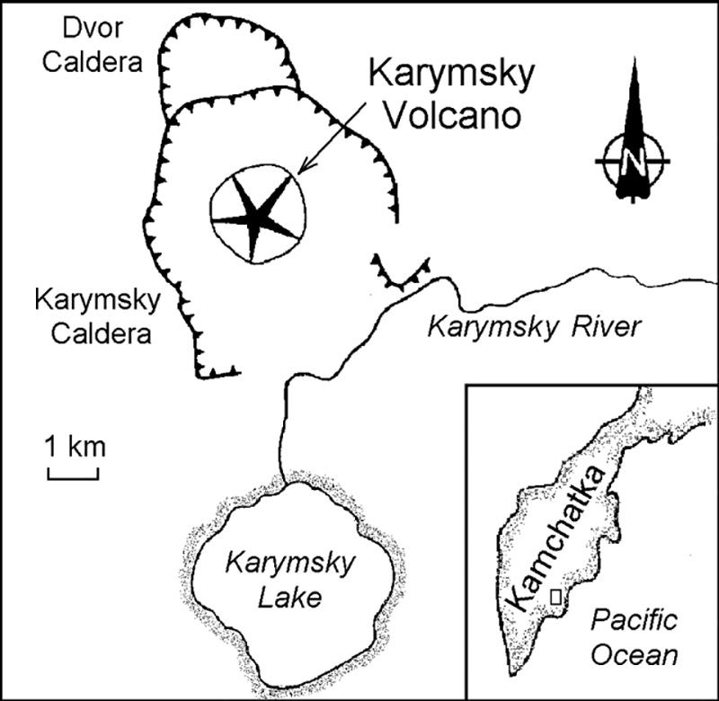 |
Figure 1. Schematic map showing some features of the SW part of the Karymsky Volcanic Center. Karymsky Lake lies within the Akademia Nauk Caldera. Courtesy of the Institute of Volcanology. |
Precursory seismicity. Large tectonic earthquakes in the Kronotsky Gulf have historically been among the precursors to eruptions from Karymsky and Maly Semiachik volcanoes. At 1926 on 31 December 1995, a M 5.6 earthquake occurred in the Kronotsky Gulf (50-60 km NE) at a depth of ~60 km. Earthquake swarms are common beneath the large (50 x 35 km) Karymsky Volcanic Center, but an unusually large swarm started on the evening of 1 January with hypocenters to depths of 80 km (figure 2). These followed a M 5.2 foreshock, and at 2157 a shallow M 6.9 earthquake took place centered ~25 km S of Karymsky; this was the largest earthquake recorded beneath the Kamchatkan volcanoes during the past 50 years. Scientists from the Institute of Volcanology and the Kamchatkan Experimental-Methodical Seismological Department of Geophysical Survey, Russian Academy of Sciences, flew to the epicentral zone of the continuing earthquake swarm and observed the onset of the eruption.
 |
Figure 2. Map and cross-sections of epicenters from the earthquake swarm at Karymsky Volcanic Center that began on 1 January 1996. Cross-section A-B (below map) trends approximately NW-SE, and cross-section C-D (left of map) trends approximately NE-SW. Courtesy of the Institute of Volcanology. |
Early eruptions at Karymsky volcano. On the afternoon of 2 January the eruption began on Karymsky's upper SW flank 50 m below the old summit crater and from the Akademia Nauk caldera lake, ~6 km S (figure 3). Ash and gas clouds from the summit vent fed a plume rising to 1 km above the crater; the ash-flow rate was estimated to be several cubic meters per second. The eruption cloud extended E towards the ocean and ashfall was visible 40-50 km away.
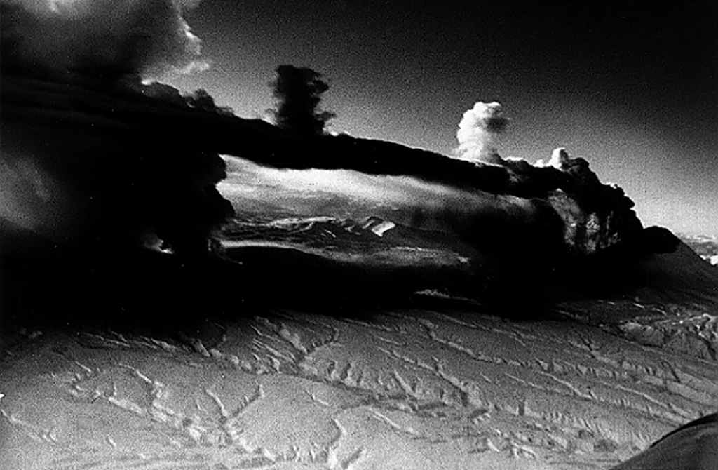 |
Figure 3. Simultaneous eruptions of Karymsky (right) and Akademia Nauk (left) volcanoes, 2 January 1996. Distance between the summit vent of Karymsky and subaqueous vents in the Akademia Nauk caldera lake is 6 km. The Karymsky cone is 700 m high. Courtesy of the Institute of Volcanology. |
On the evening on 3 January another crater formed on Karymsky; it looked like a 30-m-diameter amphitheater open to the SW. Sub-vertical Vulcanian explosions occurred from this crater to an altitude of 1 km. Over the next few days, explosions sent gas-and-ash emissions 300-1,100 m high almost every minute.
During the first three days of the eruption, ~500-800 x 103 tons of solid materials, including ash, lapilli, cinder, and bombs, were ejected at Karymsky. During the next 2-3.5 months ~3-4 x 10³ tons of andesite-dacite tephra (SiO2 61%) and a small amount of bombs were ejected. An area with a radius of 15-20 km was covered by an ash layer several millimeters thick. The layer's thickness increased along the ashfall axis, reaching 20-30 mm at 4-5 km from the source.
Early eruptions at Akademia Nauk caldera lake. Violent subaqueous explosions on 2 January took place several times every hour in the N part of the 5-km-wide Akademia Nauk caldera lake (figure 4). Explosion clouds rose to 8 km altitude, but most of the tephra fell back into the lake. Ash from Karymsky Lake covered Akademia Nauk volcano and its surroundings. The head of the Karymsky River had its valley and adjacent flood-lands inundated by high water and mud flows.
 |
Figure 4. One of the powerful subaqueous explosions from the N part of Karymsky Lake (Akademia Nauk Caldera), 2 January 1996. The base of the growing cloud is ~1 km wide. Courtesy of the Institute of Volcanology. |
Although the Akademia Nauk caldera lake had been ice-covered during the winter, after the January explosions water temperature reached 25°C, pH decreased from 7.5 to 3.1-3.2, and mineralization increased from 0.1 g/l to 0.9 g/l. Thermal water compositionally similar to those of the Karymsky springs started to discharge at a new shoal in the N part of the lake. According to preliminary estimates, ~0.015 km3 of material was supplied to the lake during the eruption.
After the lake water had cleared, a subaqueous deposit around the main explosion vent (with a diameter of 1 km) was observed. The N part of the deposit, ~1 km2, was exposed at the surface, forming an arched spit with the adjoining peninsula (figure 5). According to preliminary estimates, ~5-10 x 106 m3 of tephra including sand and rounded fragments of various sizes, and many bombs, formed the deposit there. Their composition ranged from basaltic andesite to andesite-dacite. The volume of deposits on the bottom of the lake is much greater.
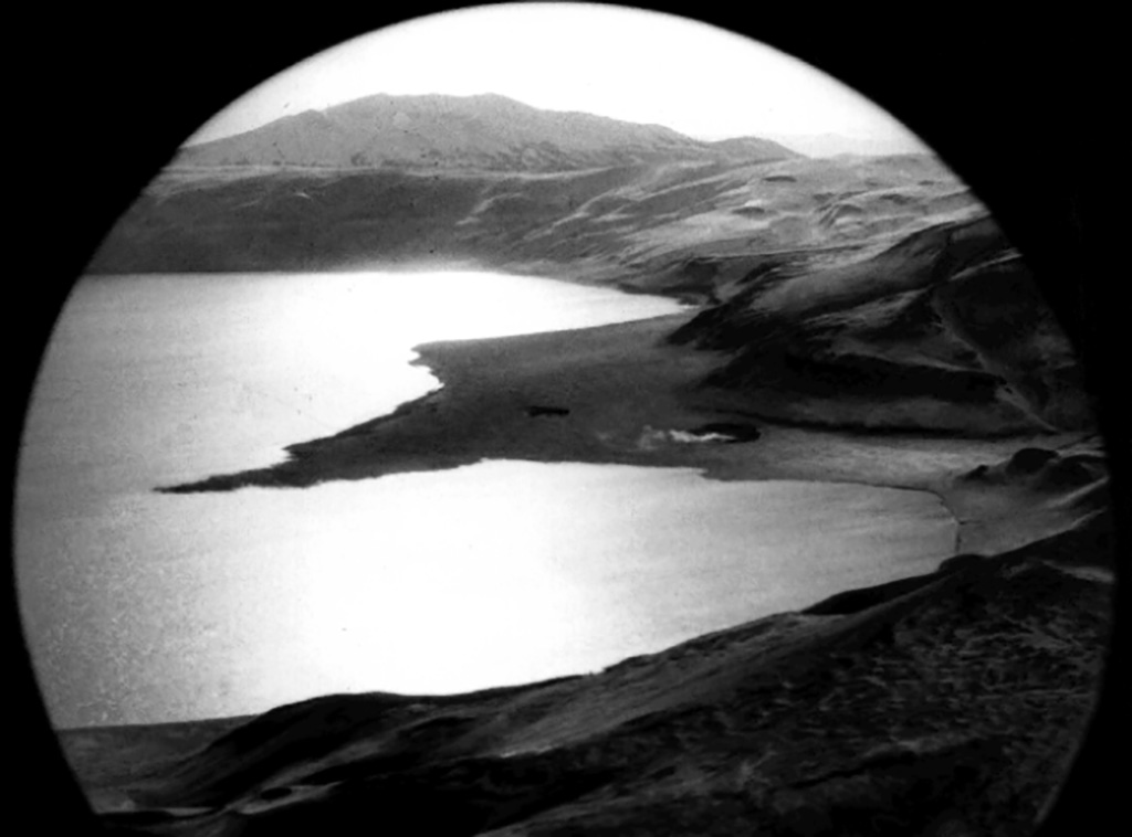 |
Figure 5. View of Karymsky Lake showing the new 1-km-wide peninsula formed by subaqueous explosion deposits on 2 January 1996. The main vents are to the left of the beach arc. Courtesy of the Institute of Volcanology. |
Activity through April. During the ensuing days in January, the eruption style at Karymsky dropped to 5-6 explosions reaching 500-900 m high every hour. More vigorous single explosions were exceptional. On 13-14 January, a block-lava flow from the flank crater traveled 400 m, was 50-70 m wide, and averaged 6-10 m thick. In late January the interval between explosions started to increase from 30 minutes to 2-3 hours.
In February only several explosions were observed each day (figure 6). In late February the number of explosions increased to 5-6/hour, but their intensity decreased. In March the number of explosions decreased but their intensity increased. In April the number of explosions increased. For example, on 23 April they took place every 5 minutes. Two additional lava flows were emitted from the flank crater in April.
A dense geodetic network developed since 1972 at the Karymsky Volcanic Center has been measured repeatedly. During the past 20 years, a horizontal extension of Akademia Nauk caldera was observed that may have indicated filling of a magma chamber under the volcano. Measurements made in February and March revealed an extension of 232 cm along the 3.5-km base and subsidence of 70 cm near the area of subaqueous explosions in the caldera lake.
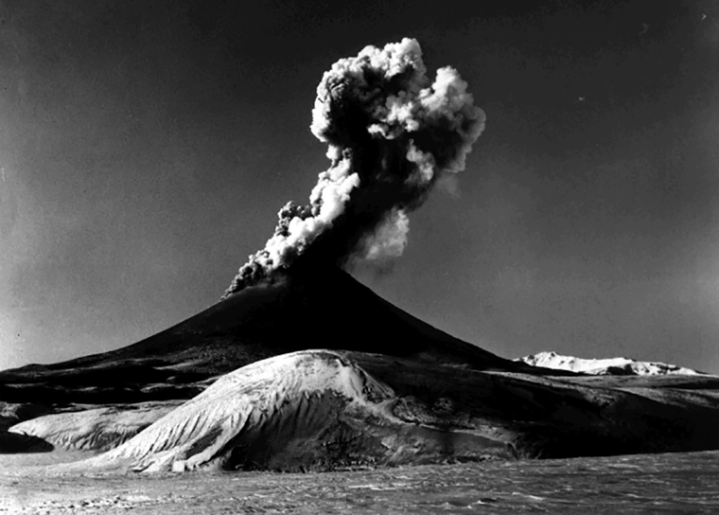 |
Figure 6. Typical Vulcanian and Strombolian activity at Karymsky, January-April 1996. Courtesy of the Institute of Volcanology. |
Karymsky Volcanic Center. Karymsky and Akademia Nauk are part of the 50 x 35 km Karymsky Volcanic Center (sometimes referred to as the Zhupanovsky volcano-tectonic depression). Located in the Eastern Kamchatka volcanic belt, 30 km from the Kronotsky Gulf and Pacific Ocean, this center contains 21 volcanic edifices, six calderas, and two historically active stratovolcanoes, Karymsky and Maly Semiachik.
The 5-km-diameter Karymsky Caldera formed 7,800 years ago and the Karymsky cone has been growing in the center of the caldera for 5,300 years, ejecting andesitic and dacitic materials. Historical reports on Karymsky's eruptions have been available since 1771. During that period of time, more than 20 prolonged eruptions were separated by quiet periods as long as 10 years. The most recent previous eruption continued from 1970 to 1982.
Akademia Nauk caldera, which was named by the famous Russian volcanologist Vladimir Vlodavetz in 1939, is located immediately to the S in the SW part of the Karymsky Volcanic Center. Its activity began about 50,000 years ago. The N part of the caldera is occupied by Karymsky Lake (4 km wide, 12.5 km2 in area, and 80 m deep). The Akademia Nauk chloride-sodium springs, with 1.3 g/l mineralization and temperatures >250°C in the interior part of the hydrothermal system, discharge along the lake's S shore.
Information Contacts: S.A. Fedotov, V.A. Budhikov, G.A. Karpov, M.A. Maguskin, Ya.D. Muravyev, V.A. Saltykov, and R.A. Shuvalov, Institute of Volcanology, Russian Academy of Sciences, Petropavlovsk-Kamchatsky, 683006, Russia.
The Global Volcanism Program has no Weekly Reports available for Akademia Nauk.
Reports are organized chronologically and indexed below by Month/Year (Publication Volume:Number), and include a one-line summary. Click on the index link or scroll down to read the reports.
Explosive eruption from Karymsky Lake and new crater at summit
Periods of seismic unrest have occurred several times in the past 12 months, including one episode in April 1995 (BGVN 19:05), and the volcano usually emits a continuous steam plume. Based on recorded seismic activity, an eruption apparently began during 1700-1900 on 1 January. Russian aviation sources reported an ash plume to 7 km altitude at approximately 1130 the next day. A satellite image at 1400 on 2 January showed that the plume had extended at least 200 km SE and S of the volcano. Several aviation notices (SIGMETs) were issued concerning the ash plume. GMS satellite imagery revealed multiple ash emissions on 2 January, with the cloud height estimated at ~7 km. Satellite data on 3 January continued to show multiple low-level (below 5,400 m) ash bursts of short duration that drifted S and dissipated within an hour.
When the volcano was visited by Vladimir Kirianov and Yuri Doubik of the Institute of Volcanic Geology and Geochemistry between 1330 and 1630 on 3 January, they discovered that the initial eruption had vented from the N end of Karymsky Lake. The lake occupies the 5-km-diameter late-Pleistocene Akademia Nauk caldera, ~5 km S of Karymsky volcano proper. However, by the time of their visit activity had shifted to Karymsky volcano where a new crater had formed on the SSW side of the summit, adjacent to the old crater. The new crater, approximately the same size as the old crater, produced explosions every 1-5 minutes that fed a thick black ash plume to an altitude of ~2.5 km moving E. Fresh ashfall was widespread throughout the 5-km-wide Karymsky caldera and for a considerable area to the E and N. Karymsky Lake was yellow-gray in color and mostly covered by steam and vapor. The Karymsky River, which drains the lake to the N, was completely buried in ash and no longer visible; a new beach with numerous fumaroles marked the former source of the river. Very strong seismic activity associated with the eruption included one M 6.5 earthquake on the first day of the eruption. Seismic stations as far as 110 km from the volcano recorded the activity.
By 5 January the new summit crater was over twice the size of the old crater. A thick black ash plume had been observed the previous two days erupting explosively from the new crater to altitudes ranging of 2,400-5,500 m. Seismicity on 6 January indicated continued explosions every 1-3 minutes. Karymsky Lake remained yellow-gray and covered by steam and vapor. Seismicity through 12 January was interpreted to reflect continued, but less explosive, eruptive activity.
Karymsky, ~110 km NW of Petropavlovsk-Kamchatsky, is the most active volcano of eastern Kamchatka. The latest eruptive period began ~500 years ago; much of the cone is mantled by lava flows less than 200 years old. It has been quiescent since frequent eruptive activity during 1970-82. The volcano is capable of explosive eruptions which can send ash to over 10 km and continue sporadically for days or weeks; short lava flows are also common.
Information Contacts: Tom Miller, Alaska Volcano Observatory (AVO), a cooperative program of a) U.S. Geological Survey, 4200 University Drive, Anchorage, AK 99508-4667, USA, b) Geophysical Institute, University of Alaska, PO Box 757320, Fairbanks, AK 99775-7320, USA, and c) Alaska Division of Geological & Geophysical Surveys, 794 University Ave., Suite 200, Fairbanks, AK 99709, USA; Vladimir Kirianov and Yuri Doubik, Institute of Volcanic Geology and Geochemistry, Piip Ave. 9, Petropavlovsk-Kamchatsky, 683006, Russia; NOAA/NESDIS Synoptic Analysis Branch (SAB) , Room 401, 5200 Auth Road, Camp Springs, MD 20746, USA.
More details about the early January eruptions
According to the Institute of Volcanology (IV), the eruption on 2 January (BGVN 21:01) began around 0800. This activity was preceded by an upsurge in seismicity that started in April 1995. At 1926 on 31 December 1995, a M 5.8 earthquake occurred in the Kronotsky gulf, 50-60 km NE of the volcano. On 1 January at 2057 an earthquake of M 5.2 in the Karymsky region was followed at 2157 by a M 6.9 event centered ~25 km S of the volcano. During the next day there were more than 10 aftershocks of M >= 5.0. On 2 January at 1540, a group of IV volcanologists arrived by helicopter. Eruptive centers were observed near the summit and 5-6 km S in Karymsky Lake (maximum depth 115 m), which fills the Akademii Nauk caldera.
The eruption began with formation of a vent with a diameter of 20-30 m, located 50 m below the summit. Violent emissions of ash-rich gas jets rose to 1 km from another vent on the SW slope. Steam-and-gas jets, occasionally with black-colored matter, were also ejected to several hundred meters from beneath the surface of Karymsky Lake. The presumed eruptive center was 100-200 m from the shore in the NW sector of the lake. Turbulent steam-and-gas plumes rose 5-6 km above the surface from a 200-m-diameter area. Ice covering the lake had completely melted.
On 3 January the near-summit vent increased in size to 50 m in diameter. Gas and steam blasts alternated with ash ejections from the two simultaneously active vents on the volcano. Ash was usually ejected from the upper vent, and a white-colored plume was emitted from the lower vent. Ash ejections lasted 2-3 minutes, and gas blasts lasted 1.5-2 minutes. An ash-and-gas column rose 1-1.2 km and was blown E and SE by the wind. The surface of Karymsky Lake steamed intensely, sending clouds 800-1,000 m above the lake. Areas of green water were visible through breaks in the clouds, and a newly-formed black beach was seen. In the N and NE sector of the lake a narrow spit, beginning from the source of the Karymsky river and extending 250-300 m to the center of the lake, had formed. The water level in the lake had dropped a few meters. The upper reaches of the river had dried up, but on 2 January waves from the submarine eruption (up to 10 m high or more) overflowed the N shore, flooding a wide valley 1.5 km below the source. During a surveillance flight on 4 January, large areas of the valley were covered by black mud. The beach contained three fumarolic vents along the NE-trending fault zone. Within a radius of 500-800 m of the source of the Karymsky River, the surrounding snow-covered hills contained thousands of holes with diameters ranging from 10 cm to 1.5-2 m formed by lithic blocks ejected from the lake. The water level of the lake continued to fall because of intense evaporation.
Light-gray dacitic ash covered an area of about 150-200 km2. At a distance of 8 km from the volcano fractions ranging from 0.16 to 0.06 mm dominated. Estimates made by S.A. Fedotov indicated that on 2 and 3 January the ash ejection rate from the summit crater reached 3-4 tons/second.
Routine observations from 2 January through 11 February showed that the climactic phase of the subaqueous eruption continued for no more than 12-15 hours. That eruption consisted of frequent explosions during which a vapor-gas mixture with lithic material was ejected to the surface. In the N sector of the lake at the shore W of the Karymsky River, damaged trees provided evidence of two eruptive sources 500-600 m from each other. This zone contained the main concentration of bomb material ejected from the lake. A portion of the shoreline (150-200 m long and 5-15 m wide) E of the river sank several meters into the lake. The main eruption center was 500 m from the shore, but smaller peripheral centers were also observed. As a result of the eruption, in the NNW sector of the lake, a beach in the form of a wide 0.4 km2 cape was produced, as well as a narrow spit extending SE from the old shore. The length of the new shoreline was 2.4 km, and a large shoal was observed around the new peninsula. According to the preliminary estimates, the ejected deposits in the lake are at least 1 km2 in area and 5-10 x 106 m3 in volume.
Thermal springs that discharge at the S shore of Karymsky Lake were destroyed by ejecta from this eruption, and several new mud pots were formed; chemical composition of the solutions was unchanged. Near the center of the new beach, composed of sand-gravel and bomb material, a chain of five explosive vents with diameters from 1.5 to 30 m was observed. At the N end was a thermal site with a diameter of ~50 m that exhibited intense vapor emission and was covered by sublimates; visiting scientists detected a hydrogen sulfide odor. A dry funnel with a diameter of ~3 m and high gas emission at a temperature of 97°C was in the center of this site. Other explosion funnels had water at a depth of 1.2-1.5 m with temperatures from 33 to 70°C. The three funnels closest to the lake and on the opposite shore had gas emissions with temperatures of 97-98°C.
On 4 January run-off from the lake ceased owing to damming by ejected material. Analyses of water samples from the lake, river, and various hot springs in the area indicated that there had been chemical contributions to the lake water by an underlying magma body.
Information Contacts: G.A. Karpov, Ya.D. Muravyev, R.A. Shuvalov, S.M. Fazlullin, and V.N. Chebrov, Institute of Volcanology, Far East Division, Russian Academy of Sciences, Petropavlovsk-Kamchatsky, 683006, Russia.
Eruptions continue through April; more details of early January activity
Eruptions began on 2 January from the summit of Karymsky and from the lake (Karymsky Lake) within the Akademia Nauk caldera (figure 1), previously considered to be extinct (BGVN 21:01-21:03). Eruptive activity at [Karymsky] continued through the end of April.
|
Figure 1. Schematic map showing some features of the SW part of the Karymsky Volcanic Center. Karymsky Lake lies within the Akademia Nauk Caldera. Courtesy of the Institute of Volcanology. |
Precursory seismicity. Large tectonic earthquakes in the Kronotsky Gulf have historically been among the precursors to eruptions from Karymsky and Maly Semiachik volcanoes. At 1926 on 31 December 1995, a M 5.6 earthquake occurred in the Kronotsky Gulf (50-60 km NE) at a depth of ~60 km. Earthquake swarms are common beneath the large (50 x 35 km) Karymsky Volcanic Center, but an unusually large swarm started on the evening of 1 January with hypocenters to depths of 80 km (figure 2). These followed a M 5.2 foreshock, and at 2157 a shallow M 6.9 earthquake took place centered ~25 km S of Karymsky; this was the largest earthquake recorded beneath the Kamchatkan volcanoes during the past 50 years. Scientists from the Institute of Volcanology and the Kamchatkan Experimental-Methodical Seismological Department of Geophysical Survey, Russian Academy of Sciences, flew to the epicentral zone of the continuing earthquake swarm and observed the onset of the eruption.
|
Figure 2. Map and cross-sections of epicenters from the earthquake swarm at Karymsky Volcanic Center that began on 1 January 1996. Cross-section A-B (below map) trends approximately NW-SE, and cross-section C-D (left of map) trends approximately NE-SW. Courtesy of the Institute of Volcanology. |
Early eruptions at Karymsky volcano. On the afternoon of 2 January the eruption began on Karymsky's upper SW flank 50 m below the old summit crater and from the Akademia Nauk caldera lake, ~6 km S (figure 3). Ash and gas clouds from the summit vent fed a plume rising to 1 km above the crater; the ash-flow rate was estimated to be several cubic meters per second. The eruption cloud extended E towards the ocean and ashfall was visible 40-50 km away.
|
Figure 3. Simultaneous eruptions of Karymsky (right) and Akademia Nauk (left) volcanoes, 2 January 1996. Distance between the summit vent of Karymsky and subaqueous vents in the Akademia Nauk caldera lake is 6 km. The Karymsky cone is 700 m high. Courtesy of the Institute of Volcanology. |
On the evening on 3 January another crater formed on Karymsky; it looked like a 30-m-diameter amphitheater open to the SW. Sub-vertical Vulcanian explosions occurred from this crater to an altitude of 1 km. Over the next few days, explosions sent gas-and-ash emissions 300-1,100 m high almost every minute.
During the first three days of the eruption, ~500-800 x 103 tons of solid materials, including ash, lapilli, cinder, and bombs, were ejected at Karymsky. During the next 2-3.5 months ~3-4 x 10³ tons of andesite-dacite tephra (SiO2 61%) and a small amount of bombs were ejected. An area with a radius of 15-20 km was covered by an ash layer several millimeters thick. The layer's thickness increased along the ashfall axis, reaching 20-30 mm at 4-5 km from the source.
Early eruptions at Akademia Nauk caldera lake. Violent subaqueous explosions on 2 January took place several times every hour in the N part of the 5-km-wide Akademia Nauk caldera lake (figure 4). Explosion clouds rose to 8 km altitude, but most of the tephra fell back into the lake. Ash from Karymsky Lake covered Akademia Nauk volcano and its surroundings. The head of the Karymsky River had its valley and adjacent flood-lands inundated by high water and mud flows.
|
Figure 4. One of the powerful subaqueous explosions from the N part of Karymsky Lake (Akademia Nauk Caldera), 2 January 1996. The base of the growing cloud is ~1 km wide. Courtesy of the Institute of Volcanology. |
Although the Akademia Nauk caldera lake had been ice-covered during the winter, after the January explosions water temperature reached 25°C, pH decreased from 7.5 to 3.1-3.2, and mineralization increased from 0.1 g/l to 0.9 g/l. Thermal water compositionally similar to those of the Karymsky springs started to discharge at a new shoal in the N part of the lake. According to preliminary estimates, ~0.015 km3 of material was supplied to the lake during the eruption.
After the lake water had cleared, a subaqueous deposit around the main explosion vent (with a diameter of 1 km) was observed. The N part of the deposit, ~1 km2, was exposed at the surface, forming an arched spit with the adjoining peninsula (figure 5). According to preliminary estimates, ~5-10 x 106 m3 of tephra including sand and rounded fragments of various sizes, and many bombs, formed the deposit there. Their composition ranged from basaltic andesite to andesite-dacite. The volume of deposits on the bottom of the lake is much greater.
|
Figure 5. View of Karymsky Lake showing the new 1-km-wide peninsula formed by subaqueous explosion deposits on 2 January 1996. The main vents are to the left of the beach arc. Courtesy of the Institute of Volcanology. |
Activity through April. During the ensuing days in January, the eruption style at Karymsky dropped to 5-6 explosions reaching 500-900 m high every hour. More vigorous single explosions were exceptional. On 13-14 January, a block-lava flow from the flank crater traveled 400 m, was 50-70 m wide, and averaged 6-10 m thick. In late January the interval between explosions started to increase from 30 minutes to 2-3 hours.
In February only several explosions were observed each day (figure 6). In late February the number of explosions increased to 5-6/hour, but their intensity decreased. In March the number of explosions decreased but their intensity increased. In April the number of explosions increased. For example, on 23 April they took place every 5 minutes. Two additional lava flows were emitted from the flank crater in April.
A dense geodetic network developed since 1972 at the Karymsky Volcanic Center has been measured repeatedly. During the past 20 years, a horizontal extension of Akademia Nauk caldera was observed that may have indicated filling of a magma chamber under the volcano. Measurements made in February and March revealed an extension of 232 cm along the 3.5-km base and subsidence of 70 cm near the area of subaqueous explosions in the caldera lake.
|
Figure 6. Typical Vulcanian and Strombolian activity at Karymsky, January-April 1996. Courtesy of the Institute of Volcanology. |
Karymsky Volcanic Center. Karymsky and Akademia Nauk are part of the 50 x 35 km Karymsky Volcanic Center (sometimes referred to as the Zhupanovsky volcano-tectonic depression). Located in the Eastern Kamchatka volcanic belt, 30 km from the Kronotsky Gulf and Pacific Ocean, this center contains 21 volcanic edifices, six calderas, and two historically active stratovolcanoes, Karymsky and Maly Semiachik.
The 5-km-diameter Karymsky Caldera formed 7,800 years ago and the Karymsky cone has been growing in the center of the caldera for 5,300 years, ejecting andesitic and dacitic materials. Historical reports on Karymsky's eruptions have been available since 1771. During that period of time, more than 20 prolonged eruptions were separated by quiet periods as long as 10 years. The most recent previous eruption continued from 1970 to 1982.
Akademia Nauk caldera, which was named by the famous Russian volcanologist Vladimir Vlodavetz in 1939, is located immediately to the S in the SW part of the Karymsky Volcanic Center. Its activity began about 50,000 years ago. The N part of the caldera is occupied by Karymsky Lake (4 km wide, 12.5 km2 in area, and 80 m deep). The Akademia Nauk chloride-sodium springs, with 1.3 g/l mineralization and temperatures >250°C in the interior part of the hydrothermal system, discharge along the lake's S shore.
Information Contacts: S.A. Fedotov, V.A. Budhikov, G.A. Karpov, M.A. Maguskin, Ya.D. Muravyev, V.A. Saltykov, and R.A. Shuvalov, Institute of Volcanology, Russian Academy of Sciences, Petropavlovsk-Kamchatsky, 683006, Russia.
|
|
||||||||||||||||||||||||||||
There is data available for 4 confirmed eruptive periods.
1996 Jan 2 - 1996 Jan 3 Confirmed Eruption (Explosive / Effusive) VEI: 3
| Episode 1 | Eruption (Explosive / Effusive) | North margin of Karymsky Lake | ||||||||||||||||||||||||||||||||||||||||||||||||||||||||||||||||||||
|---|---|---|---|---|---|---|---|---|---|---|---|---|---|---|---|---|---|---|---|---|---|---|---|---|---|---|---|---|---|---|---|---|---|---|---|---|---|---|---|---|---|---|---|---|---|---|---|---|---|---|---|---|---|---|---|---|---|---|---|---|---|---|---|---|---|---|---|---|---|
| 1996 Jan 2 - 1996 Jan 3 | Evidence from Observations: Reported | ||||||||||||||||||||||||||||||||||||||||||||||||||||||||||||||||||||
|
List of 12 Events for Episode 1 at North margin of Karymsky Lake
|
|||||||||||||||||||||||||||||||||||||||||||||||||||||||||||||||||||||
0950 BCE (?) Confirmed Eruption (Explosive / Effusive)
| Episode 1 | Eruption (Explosive / Effusive) | North of Karymsky Lake, Tephra layer SC | ||||||||||||||||||
|---|---|---|---|---|---|---|---|---|---|---|---|---|---|---|---|---|---|---|---|
| 0950 BCE (?) - Unknown | Evidence from Isotopic: 14C (calibrated) | ||||||||||||||||||
|
List of 2 Events for Episode 1 at North of Karymsky Lake, Tephra layer SC
|
|||||||||||||||||||
3850 BCE (?) Confirmed Eruption (Explosive / Effusive)
| Episode 1 | Eruption (Explosive / Effusive) | North of Karymsky Lake (Lagerny cone) | ||||||||||||||||||
|---|---|---|---|---|---|---|---|---|---|---|---|---|---|---|---|---|---|---|---|
| 3850 BCE (?) - Unknown | Evidence from Isotopic: 14C (calibrated) | ||||||||||||||||||
|
List of 2 Events for Episode 1 at North of Karymsky Lake (Lagerny cone)
|
|||||||||||||||||||
5500 BCE ± 500 years Confirmed Eruption (Explosive / Effusive) VEI: 3 (?)
| Episode 1 | Eruption (Explosive / Effusive) | N margin of caldera lake (Karymsky maar) | ||||||||||||||||||||||||||||||||||||||
|---|---|---|---|---|---|---|---|---|---|---|---|---|---|---|---|---|---|---|---|---|---|---|---|---|---|---|---|---|---|---|---|---|---|---|---|---|---|---|---|
| 5500 BCE ± 500 years - Unknown | Evidence from Isotopic: 14C (calibrated) | ||||||||||||||||||||||||||||||||||||||
|
List of 6 Events for Episode 1 at N margin of caldera lake (Karymsky maar)
|
|||||||||||||||||||||||||||||||||||||||
This compilation of synonyms and subsidiary features may not be comprehensive. Features are organized into four major categories: Cones, Craters, Domes, and Thermal Features. Synonyms of features appear indented below the primary name. In some cases additional feature type, elevation, or location details are provided.
Synonyms |
||||
| Academii Nauk | Karymskoe, Lake | Karymsky Lake | ||||
Cones |
||||
| Feature Name | Feature Type | Elevation | Latitude | Longitude |
| Beliankin | Stratovolcano | 1180 m | 53° 56' 0.00" N | 159° 24' 0.00" E |
Craters |
||||
| Feature Name | Feature Type | Elevation | Latitude | Longitude |
| Karymsky | Maar | |||
| Karymsky Lake | Pleistocene caldera | 53° 59' 0.00" N | 159° 27' 0.00" E | |
| Odnoboky | Pleistocene caldera | 53° 58' 0.00" N | 159° 27' 0.00" E | |
| Polovinka | Pleistocene caldera | |||
Domes |
||||
| Feature Name | Feature Type | Elevation | Latitude | Longitude |
| Lagerny | Dome | |||
Thermal |
||||
| Feature Name | Feature Type | Elevation | Latitude | Longitude |
| Akademia Nauk Springs | Hot Spring | |||
| Karymskaya River Springs | Hot Spring | |||
| Northern Shore Springs | Hot Spring | |||
| Piip | Thermal | |||
| Ushakovskaya | Thermal | |||
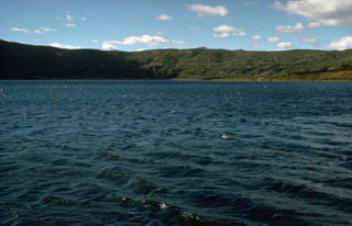 The 3 x 5 km lake-filled Akademia Nauk caldera formed during the late Pleistocene within an earlier caldera. The caldera was active during the Holocene, low-temperature geothermal activity took place along the shores of the caldera lake, and an eruption took place in 1996.
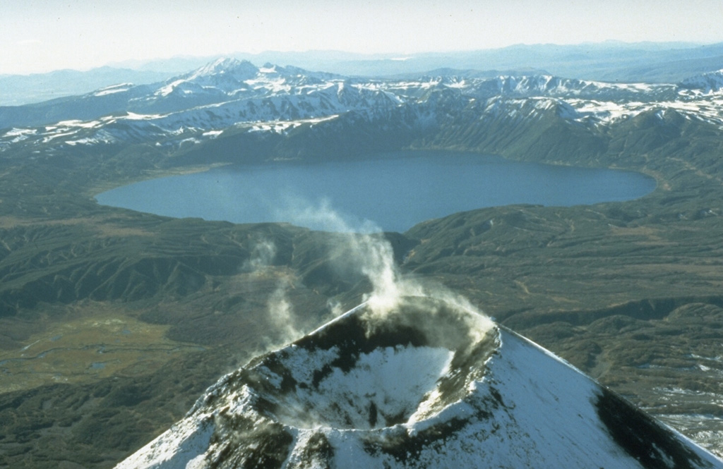
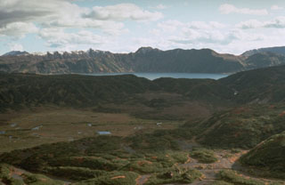 Akademia Nauk caldera in central Kamchatka, seen here from the slopes of Karymsky volcano looking SW, is one of two overlapping calderas formed during the late Pleistocene within the 15-km-wide Polovinka caldera. The snow-capped ridge to the upper left is the southern rim of Odnoboky caldera, and the northern rim is truncated by the Akademia Nauk. Karymsky Lake fills the 3 x 5 km Akademia Nauk caldera that most recently erupted in 1996.
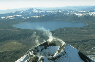 The lake-filled Akademia Nauk caldera, seen here from the north with Kaymsky in the foreground, is one of three volcanoes constructed within a large mid-Pleistocene caldera. Two nested calderas, 4 x 5 km Odnoboky and 3 x 5 km Akademia Nauk formed during the late-Pleistocene. The first historical eruption from Akademia Nauk took take place on 2 January 1996, when a brief, day-long explosive eruption occurred from vents beneath the NNW part of the caldera lake.
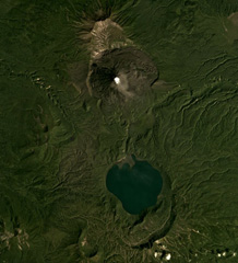 Karymsky is in the north and the Akademia Nauk caldera containing Karymsky Lake is in the south of this August 2019 Planet Labs satellite image monthly mosaic (N is at the top; this image is approximately 19 km across). Along the northern rim of the lake is the 1996 eruption vent, and south of the lake is the Polovinka caldera rim. The current Karymsky cone has formed within the older Karymsky caldera, and adjacent to the northern rim is the Dvor caldera.
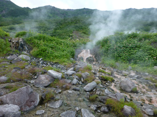 Geothermal activity occurs along the southern rim of the Akademia Nauk caldera, above the Karymsky lake. This 19 July 2014 view shows gas emissions from several areas, and geothermal fluids from a hot spring.
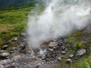 A hot spring on the southern caldera rim of Akademia Nauk is ejecting water and steam/volcanic gases on 19 July 2015 within a broader geothermal area. Geologists are behind the plume for scale.
There are no samples for Akademia Nauk in the Smithsonian's NMNH Department of Mineral Sciences Rock and Ore collection.
| Copernicus Browser | The Copernicus Browser replaced the Sentinel Hub Playground browser in 2023, to provide access to Earth observation archives from the Copernicus Data Space Ecosystem, the main distribution platform for data from the EU Copernicus missions. |
| MIROVA | Middle InfraRed Observation of Volcanic Activity (MIROVA) is a near real time volcanic hot-spot detection system based on the analysis of MODIS (Moderate Resolution Imaging Spectroradiometer) data. In particular, MIROVA uses the Middle InfraRed Radiation (MIR), measured over target volcanoes, in order to detect, locate and measure the heat radiation sourced from volcanic activity. |
| MODVOLC Thermal Alerts | Using infrared satellite Moderate Resolution Imaging Spectroradiometer (MODIS) data, scientists at the Hawai'i Institute of Geophysics and Planetology, University of Hawai'i, developed an automated system called MODVOLC to map thermal hot-spots in near real time. For each MODIS image, the algorithm automatically scans each 1 km pixel within it to check for high-temperature hot-spots. When one is found the date, time, location, and intensity are recorded. MODIS looks at every square km of the Earth every 48 hours, once during the day and once during the night, and the presence of two MODIS sensors in space allows at least four hot-spot observations every two days. Each day updated global maps are compiled to display the locations of all hot spots detected in the previous 24 hours. There is a drop-down list with volcano names which allow users to 'zoom-in' and examine the distribution of hot-spots at a variety of spatial scales. |
|
WOVOdat
Single Volcano View Temporal Evolution of Unrest Side by Side Volcanoes |
WOVOdat is a database of volcanic unrest; instrumentally and visually recorded changes in seismicity, ground deformation, gas emission, and other parameters from their normal baselines. It is sponsored by the World Organization of Volcano Observatories (WOVO) and presently hosted at the Earth Observatory of Singapore.
GVMID Data on Volcano Monitoring Infrastructure The Global Volcano Monitoring Infrastructure Database GVMID, is aimed at documenting and improving capabilities of volcano monitoring from the ground and space. GVMID should provide a snapshot and baseline view of the techniques and instrumentation that are in place at various volcanoes, which can be use by volcano observatories as reference to setup new monitoring system or improving networks at a specific volcano. These data will allow identification of what monitoring gaps exist, which can be then targeted by remote sensing infrastructure and future instrument deployments. |
| Volcanic Hazard Maps | The IAVCEI Commission on Volcanic Hazards and Risk has a Volcanic Hazard Maps database designed to serve as a resource for hazard mappers (or other interested parties) to explore how common issues in hazard map development have been addressed at different volcanoes, in different countries, for different hazards, and for different intended audiences. In addition to the comprehensive, searchable Volcanic Hazard Maps Database, this website contains information about diversity of volcanic hazard maps, illustrated using examples from the database. This site is for educational purposes related to volcanic hazard maps. Hazard maps found on this website should not be used for emergency purposes. For the most recent, official hazard map for a particular volcano, please seek out the proper institutional authorities on the matter. |
| IRIS seismic stations/networks | Incorporated Research Institutions for Seismology (IRIS) Data Services map showing the location of seismic stations from all available networks (permanent or temporary) within a radius of 0.18° (about 20 km at mid-latitudes) from the given location of Akademia Nauk. Users can customize a variety of filters and options in the left panel. Note that if there are no stations are known the map will default to show the entire world with a "No data matched request" error notice. |
| UNAVCO GPS/GNSS stations | Geodetic Data Services map from UNAVCO showing the location of GPS/GNSS stations from all available networks (permanent or temporary) within a radius of 20 km from the given location of Akademia Nauk. Users can customize the data search based on station or network names, location, and time window. Requires Adobe Flash Player. |
| DECADE Data | The DECADE portal, still in the developmental stage, serves as an example of the proposed interoperability between The Smithsonian Institution's Global Volcanism Program, the Mapping Gas Emissions (MaGa) Database, and the EarthChem Geochemical Portal. The Deep Earth Carbon Degassing (DECADE) initiative seeks to use new and established technologies to determine accurate global fluxes of volcanic CO2 to the atmosphere, but installing CO2 monitoring networks on 20 of the world's 150 most actively degassing volcanoes. The group uses related laboratory-based studies (direct gas sampling and analysis, melt inclusions) to provide new data for direct degassing of deep earth carbon to the atmosphere. |
| Large Eruptions of Akademia Nauk | Information about large Quaternary eruptions (VEI >= 4) is cataloged in the Large Magnitude Explosive Volcanic Eruptions (LaMEVE) database of the Volcano Global Risk Identification and Analysis Project (VOGRIPA). |
| EarthChem | EarthChem develops and maintains databases, software, and services that support the preservation, discovery, access and analysis of geochemical data, and facilitate their integration with the broad array of other available earth science parameters. EarthChem is operated by a joint team of disciplinary scientists, data scientists, data managers and information technology developers who are part of the NSF-funded data facility Integrated Earth Data Applications (IEDA). IEDA is a collaborative effort of EarthChem and the Marine Geoscience Data System (MGDS). |

