

Seismicity at Makushin returned to background levels after steadily declining for almost three months following a sequence of earthquakes about 10 km E of the summit at a depth of 8 km that had started on 15 June. AVO lowered the Aviation Color Code and Volcano Alert Level remained at Green and Normal, respectively, on 8 September.
Source: US Geological Survey Alaska Volcano Observatory (AVO)
Slight increase in small earthquakes during July 2000-June 2001
The last eruption of Makushin occurred on 30 January 1995 and produced an ash cloud that rose to ~2.5 km altitude (BGVN 20:01). The Alaska Volcano Observatory reported that during July 2000 to June 2001 they detected a slight increase in the number of small earthquakes beneath Makushin. The volcano is located 25 km W of the city of Unalaska/Dutch Harbor in the eastern Aleutian Islands. Hypocenters of the earthquakes generally ranged between 0 and 8 km depth. The events had magnitudes of 0-1.5, so they were too small to be felt by humans. The earthquakes were not thought to be immediate precursors to eruptive activity because similar fluctuations in seismic activity have been observed at a number of Aleutian volcanoes and were not followed by eruptions. The level of concern color code remained at Green.
Information Contacts: Alaska Volcano Observatory (AVO), a cooperative program of a) U.S. Geological Survey, 4200 University Drive, Anchorage, AK 99508-4667, USA (URL: http://www.avo.alaska.edu/), b) Geophysical Institute, University of Alaska, PO Box 757320, Fairbanks, AK 99775-7320, USA, and c) Alaska Division of Geological & Geophysical Surveys, 794 University Ave., Suite 200, Fairbanks, AK 99709, USA.
2020: June
| July
| September
2001: May
Seismicity at Makushin returned to background levels after steadily declining for almost three months following a sequence of earthquakes about 10 km E of the summit at a depth of 8 km that had started on 15 June. AVO lowered the Aviation Color Code and Volcano Alert Level remained at Green and Normal, respectively, on 8 September.
Source: US Geological Survey Alaska Volcano Observatory (AVO)
AVO reported that small earthquakes in an area about 10 km E of the Makushin’s summit and at a depth of about 8 km continued to be detected during 15-21 July. Since the onset of seismicity on 15 June, the earthquakes had generally decreased in both size and rate. No surficial activity was visible in satellite or webcam images; only typical minor steaming from the summit crater lake. Weakly elevated surface temperatures were identified in satellite data during 20-21 July. The Aviation Color Code and Volcano Alert Level remained at Yellow and Advisory, respectively.
Source: US Geological Survey Alaska Volcano Observatory (AVO)
AVO reported continuing numerous smaller earthquakes in an area about 10 km E of the Makushin’s summit at a depth of about 8 km during 24-30 June; the frequency and magnitude had been declining since 15 June but the rate became variable on 24 June. No surficial activity was visible in satellite or webcam images; only typical minor steaming from summit crater lake. Earthquakes with a M 3 and M 3.8 were recorded at 1653 and 1802 on 28 June, with the larger event strongly felt in Unalaska (14 km E). The Aviation Color Code and Volcano Alert Level remained at Yellow and Advisory, respectively.
Source: US Geological Survey Alaska Volcano Observatory (AVO)
AVO reported that numerous smaller earthquakes in an area about 12 km SE of Makushin’s summit were recorded after two events greater than M 4 occurred on 15 June. The earthquake activity continued during 16-23 June, though at a declining rate and magnitudes. No surficial activity was visible in satellite or webcam images; only typical minor steaming from summit fumaroles was visible. The Aviation Color Code and Volcano Alert Level remained at Yellow and Advisory, respectively.
Source: US Geological Survey Alaska Volcano Observatory (AVO)
AVO reported that over a period of several hours on 15 June there were two earthquakes in the vicinity of Makushin that were greater than M 4 and one greater than M 3. The events were located about 11 km SE of the summit at a depth of about 8 km, and felt in Unalaska (14 km E). Numerous smaller earthquakes were recorded, though not felt by Unalaska residents. AVO noted that the earthquakes represented a departure from background levels and were possibly indicative of volcanic unrest; the Aviation Color Code and Volcano Alert Level were respectively raised to Yellow and Advisory. The report noted that aftershocks were continuing.
Source: US Geological Survey Alaska Volcano Observatory (AVO)
Since July 2000 AVO has detected a slight increase in the number of small earthquakes beneath Makushin. The earthquakes generally ranged in depth between 0 and 8 km and were too small to be felt by humans (M0-1.5). The seismic activity was not considered to be an immediate precursor to eruptive activity. Similar fluctuations in earthquake activity have been observed at a number of Aleutian volcanoes that did not result in an eruption. The Concern Color Code remained at Green.
Source: US Geological Survey Alaska Volcano Observatory (AVO)
Reports are organized chronologically and indexed below by Month/Year (Publication Volume:Number), and include a one-line summary. Click on the index link or scroll down to read the reports.
Recently-ejected tephra; vapor emission
On 8 July, J. Hauptmann, G. Gunther, and R. [Steuer] visited a seismic station on the E flank and overflew the summit. More than ten roughly circular vents emitted vapor from the summit area, a flat region about 100 m across. The largest vent was about 30 m in diameter, and others were around 10 m across. An H2S odor was detected, but no ash or incandescent material was observed.
About 60 m below the summit on the S flank, an explosion vent had recently ejected tephra ranging in size from ash to blocks, deposited in streaks aligned roughly toward the SE. Some impact craters were present in the deposit area, which extended 30-60 m from the vent.
Information Contacts: J. Hauptmann, G. Gunther, R. Steuer, and S. McNutt, Lamont-Doherty Geological Observatory (LDGO).
Increased steaming from six summit area vents
On 20 December, pilot T. Madsen (Aleutian Air) noticed anomalous amounts of steam rising from six large and closely spaced steam vents just E of the summit. The largest plume was 500-600 m high. No ash was observed in the white plumes. Air temperature at 2,400 m was -6.7°C, warm for that altitude. Steaming remained anomalously vigorous for the next two days before returning to a more normal level. Based on John Reeder's observations . . . since 1979, the summit steam activity is continuous and normally reaches heights of 100 m or slightly less.
Information Contacts: J. Reeder, Alaska Division of Geological and Geophysical Surveys (ADGGS).
Increased steam plume
On 28 April at 0700, James Dickson observed a 450 m vertical steam plume over Makushin that trailed SE for at least 30 km. He detected no ash in the plume.
Information Contacts: J. Reeder, ADGGS.
Small ash eruption; new steam vents
On 2 March between 1700 and 1940, a dark eruption plume rose about 900 m above the volcano and drifted SW [this was actually an eruption from Akutan; see 12:04]. After the eruption a 60-m-high steam plume remained.
An airplane pilot (T. Madsen) noted two fairly large steam vents, which he had not noticed on previous flights, on 29 February and 1 and 2 March.
Information Contacts: J. Reeder, ADGGS.
Correction: 2 March ash plume was from Akutan
The 2 March eruption plume [previously reported] was actually a plume from Akutan. Activity on 2 March was limited to a steam plume containing ash that extended at least 30 km E from the summit. Pilot H. Wilson (Peninsula Airways) observed several steam plumes rising at least 250 m above the summit and drifting at least 3 km WNW. He noted particulate matter, possibly ash, over snow in the summit region.
Information Contacts: J. Reeder, ADGGS; T. Miller, USGS Anchorage; W. Gould, NOAA/NESDIS.
Storm causes false eruption reports; sulfur smell 25 km E
"Reports of possible eruptive activity . . . 22-23 January reflected a combination of intense lightning near the volcano and a strong sulfur odor detected in Dutch Harbor, 25 km E. The lightning was apparently associated with the passing of a strong storm front, and winds were blowing directly toward Dutch Harbor.
Information Contacts: AVO.
Small steam-and-ash plume reported by pilots
A small steam-and-ash cloud observed by Coast Guard C-130 pilots at 1246 on 30 January reportedly rose to ~2,400 m altitude and was carried NE from the volcano. Several pilots reported a diminishing light brown ash plume during the next hour, and all activity apparently subsided shortly thereafter. A satellite image recorded at 1345 showed no sign of eruptive activity, but the NWS issued a SIGMET that ran until 1700.
Information Contacts: Alaska Volcano Observatory.
Slight increase in small earthquakes during July 2000-June 2001
The last eruption of Makushin occurred on 30 January 1995 and produced an ash cloud that rose to ~2.5 km altitude (BGVN 20:01). The Alaska Volcano Observatory reported that during July 2000 to June 2001 they detected a slight increase in the number of small earthquakes beneath Makushin. The volcano is located 25 km W of the city of Unalaska/Dutch Harbor in the eastern Aleutian Islands. Hypocenters of the earthquakes generally ranged between 0 and 8 km depth. The events had magnitudes of 0-1.5, so they were too small to be felt by humans. The earthquakes were not thought to be immediate precursors to eruptive activity because similar fluctuations in seismic activity have been observed at a number of Aleutian volcanoes and were not followed by eruptions. The level of concern color code remained at Green.
Information Contacts: Alaska Volcano Observatory (AVO), a cooperative program of a) U.S. Geological Survey, 4200 University Drive, Anchorage, AK 99508-4667, USA (URL: http://www.avo.alaska.edu/), b) Geophysical Institute, University of Alaska, PO Box 757320, Fairbanks, AK 99775-7320, USA, and c) Alaska Division of Geological & Geophysical Surveys, 794 University Ave., Suite 200, Fairbanks, AK 99709, USA.
|
|
||||||||||||||||||||||||||||
There is data available for 19 confirmed eruptive periods.
1995 Jan 30 - 1995 Jan 30 Confirmed Eruption (Explosive / Effusive) VEI: 1
| Episode 1 | Eruption (Explosive / Effusive) | |||||||||||||||||||||||||||||
|---|---|---|---|---|---|---|---|---|---|---|---|---|---|---|---|---|---|---|---|---|---|---|---|---|---|---|---|---|---|
| 1995 Jan 30 - 1995 Jan 30 | Evidence from Observations: Reported | ||||||||||||||||||||||||||||
|
List of 4 Events for Episode 1
|
|||||||||||||||||||||||||||||
1993 Aug 16 ± 15 days - 1994 Jan 19 (?) Confirmed Eruption (Explosive / Effusive) VEI: 1
| Episode 1 | Eruption (Explosive / Effusive) | ||||||||||||||||||||||||
|---|---|---|---|---|---|---|---|---|---|---|---|---|---|---|---|---|---|---|---|---|---|---|---|---|
| 1993 Aug 16 ± 15 days - 1994 Jan 19 (?) | Evidence from Observations: Reported | |||||||||||||||||||||||
|
List of 3 Events for Episode 1
|
||||||||||||||||||||||||
1987 Mar 2 - 1987 Mar 2 Confirmed Eruption (Explosive / Effusive) VEI: 1
| Episode 1 | Eruption (Explosive / Effusive) | ||||||||||||||||||||||||
|---|---|---|---|---|---|---|---|---|---|---|---|---|---|---|---|---|---|---|---|---|---|---|---|---|
| 1987 Mar 2 - 1987 Mar 2 | Evidence from Observations: Reported | |||||||||||||||||||||||
|
List of 3 Events for Episode 1
|
||||||||||||||||||||||||
[ 1986 Apr 28 ] Discredited Eruption
1980 May 1 ± 60 days - 1980 Jul 4 ± 3 days Confirmed Eruption (Explosive / Effusive) VEI: 1
| Episode 1 | Eruption (Explosive / Effusive) | SE side of summit | ||||||||||||||||||||||||||||
|---|---|---|---|---|---|---|---|---|---|---|---|---|---|---|---|---|---|---|---|---|---|---|---|---|---|---|---|---|---|
| 1980 May 1 ± 60 days - 1980 Jul 4 ± 3 days | Evidence from Observations: Reported | ||||||||||||||||||||||||||||
| On 8 July 1980 volcanologists from Lamont-Doherty Geological Observatory noted that, ~60 m below the summit on the S flank, an explosion vent had recently ejected tephra ranging in size from ash to blocks, leaving a small deposit in streaks aligned roughly toward the SE overlying winter snow 30-60 m from the vent (SEAN 05:07 and McNutt, 1980 pers. comm.). | |||||||||||||||||||||||||||||
|
List of 4 Events for Episode 1 at SE side of summit
|
|||||||||||||||||||||||||||||
[ 1952 Jul 2 ± 182 days ] Uncertain Eruption
| Episode 1 | Eruption (Explosive / Effusive) | ||||||||||||||
|---|---|---|---|---|---|---|---|---|---|---|---|---|---|---|
| 1952 Jul 2 ± 182 days - Unknown | Evidence from Unknown | |||||||||||||
|
List of 1 Events for Episode 1
|
||||||||||||||
1951 Dec 20 Confirmed Eruption (Explosive / Effusive) VEI: 1
| Episode 1 | Eruption (Explosive / Effusive) | ||||||||||||||||||||||||
|---|---|---|---|---|---|---|---|---|---|---|---|---|---|---|---|---|---|---|---|---|---|---|---|---|
| 1951 Dec 20 - Unknown | Evidence from Observations: Reported | |||||||||||||||||||||||
|
List of 3 Events for Episode 1
|
||||||||||||||||||||||||
1938 Oct Confirmed Eruption (Explosive / Effusive) VEI: 2
| Episode 1 | Eruption (Explosive / Effusive) | |||||||||||||||||||
|---|---|---|---|---|---|---|---|---|---|---|---|---|---|---|---|---|---|---|---|
| 1938 Oct - Unknown | Evidence from Observations: Reported | ||||||||||||||||||
|
List of 2 Events for Episode 1
|
|||||||||||||||||||
1926 Dec 30 Confirmed Eruption (Explosive / Effusive) VEI: 2
| Episode 1 | Eruption (Explosive / Effusive) | ||||||||||||||||||||||||
|---|---|---|---|---|---|---|---|---|---|---|---|---|---|---|---|---|---|---|---|---|---|---|---|---|
| 1926 Dec 30 - Unknown | Evidence from Observations: Reported | |||||||||||||||||||||||
|
List of 3 Events for Episode 1
|
||||||||||||||||||||||||
[ 1912 ] Uncertain Eruption
| Episode 1 | Eruption (Explosive / Effusive) | ||||||||||||||
|---|---|---|---|---|---|---|---|---|---|---|---|---|---|---|
| 1912 - Unknown | Evidence from Unknown | |||||||||||||
|
List of 1 Events for Episode 1
|
||||||||||||||
1907 Confirmed Eruption (Explosive / Effusive)
| Episode 1 | Eruption (Explosive / Effusive) | ||||
|---|---|---|---|---|
| 1907 - Unknown | Evidence from Observations: Reported | |||
1883 Confirmed Eruption (Explosive / Effusive) VEI: 2
| Episode 1 | Eruption (Explosive / Effusive) | ||||||||||||||||||||||||
|---|---|---|---|---|---|---|---|---|---|---|---|---|---|---|---|---|---|---|---|---|---|---|---|---|
| 1883 - Unknown | Evidence from Observations: Reported | |||||||||||||||||||||||
|
List of 3 Events for Episode 1
|
||||||||||||||||||||||||
[ 1867 ] Uncertain Eruption
| Episode 1 | Eruption (Explosive / Effusive) | ||||||||||||||
|---|---|---|---|---|---|---|---|---|---|---|---|---|---|---|
| 1867 - Unknown | Evidence from Unknown | |||||||||||||
|
List of 1 Events for Episode 1
|
||||||||||||||
1865 Confirmed Eruption (Explosive / Effusive)
| Episode 1 | Eruption (Explosive / Effusive) | ||||
|---|---|---|---|---|
| 1865 - Unknown | Evidence from Observations: Reported | |||
[ 1844 ± 1 years ] Uncertain Eruption
| Episode 1 | Eruption (Explosive / Effusive) | ||||||||||||||
|---|---|---|---|---|---|---|---|---|---|---|---|---|---|---|
| 1844 ± 1 years - Unknown | Evidence from Unknown | |||||||||||||
|
List of 1 Events for Episode 1
|
||||||||||||||
[ 1827 - 1838 ] Uncertain Eruption
| Episode 1 | Eruption (Explosive / Effusive) | |||||||||||||||||||
|---|---|---|---|---|---|---|---|---|---|---|---|---|---|---|---|---|---|---|---|
| 1827 - 1838 | Evidence from Unknown | ||||||||||||||||||
|
List of 2 Events for Episode 1
|
|||||||||||||||||||
1826 Jun Confirmed Eruption (Explosive / Effusive) VEI: 3
| Episode 1 | Eruption (Explosive / Effusive) | |||||||||||||||||||||||||||||
|---|---|---|---|---|---|---|---|---|---|---|---|---|---|---|---|---|---|---|---|---|---|---|---|---|---|---|---|---|---|
| 1826 Jun - Unknown | Evidence from Observations: Reported | ||||||||||||||||||||||||||||
|
List of 4 Events for Episode 1
|
|||||||||||||||||||||||||||||
[ 1818 ] Uncertain Eruption
| Episode 1 | Eruption (Explosive / Effusive) | ||||||||||||||
|---|---|---|---|---|---|---|---|---|---|---|---|---|---|---|
| 1818 - Unknown | Evidence from Unknown | |||||||||||||
|
List of 1 Events for Episode 1
|
||||||||||||||
1802 Confirmed Eruption (Explosive / Effusive) VEI: 3
| Episode 1 | Eruption (Explosive / Effusive) | |||||||||||||||||||
|---|---|---|---|---|---|---|---|---|---|---|---|---|---|---|---|---|---|---|---|
| 1802 - Unknown | Evidence from Observations: Reported | ||||||||||||||||||
|
List of 2 Events for Episode 1
|
|||||||||||||||||||
[ 1792 Feb 14 ] Uncertain Eruption
| Episode 1 | Eruption (Explosive / Effusive) | ||||||||||||||
|---|---|---|---|---|---|---|---|---|---|---|---|---|---|---|
| 1792 Feb 14 - Unknown | Evidence from Unknown | |||||||||||||
|
List of 1 Events for Episode 1
|
||||||||||||||
[ 1790 Jun 7 ] Uncertain Eruption
| Episode 1 | Eruption (Explosive / Effusive) | ||||||||||||||
|---|---|---|---|---|---|---|---|---|---|---|---|---|---|---|
| 1790 Jun 7 - Unknown | Evidence from Unknown | |||||||||||||
|
List of 1 Events for Episode 1
|
||||||||||||||
1768 - 1769 Confirmed Eruption (Explosive / Effusive) VEI: 3
| Episode 1 | Eruption (Explosive / Effusive) | ||||||||||||||||||||||||
|---|---|---|---|---|---|---|---|---|---|---|---|---|---|---|---|---|---|---|---|---|---|---|---|---|
| 1768 - 1769 | Evidence from Observations: Reported | |||||||||||||||||||||||
|
List of 3 Events for Episode 1
|
||||||||||||||||||||||||
1150 ± 500 years Confirmed Eruption (Explosive / Effusive)
| Episode 1 | Eruption (Explosive / Effusive) | |||||||||||||||||||
|---|---|---|---|---|---|---|---|---|---|---|---|---|---|---|---|---|---|---|---|
| 1150 ± 500 years - Unknown | Evidence from Correlation: Tephrochronology | ||||||||||||||||||
|
List of 2 Events for Episode 1
|
|||||||||||||||||||
0550 BCE ± 900 years Confirmed Eruption (Explosive / Effusive)
| Episode 1 | Eruption (Explosive / Effusive) | |||||||||||||||||||
|---|---|---|---|---|---|---|---|---|---|---|---|---|---|---|---|---|---|---|---|
| 0550 BCE ± 900 years - Unknown | Evidence from Correlation: Tephrochronology | ||||||||||||||||||
|
List of 2 Events for Episode 1
|
|||||||||||||||||||
1750 BCE (?) Confirmed Eruption (Explosive / Effusive)
| Episode 1 | Eruption (Explosive / Effusive) | |||||||||||||||||||
|---|---|---|---|---|---|---|---|---|---|---|---|---|---|---|---|---|---|---|---|
| 1750 BCE (?) - Unknown | Evidence from Isotopic: 14C (uncalibrated) | ||||||||||||||||||
|
List of 2 Events for Episode 1
|
|||||||||||||||||||
3650 BCE ± 1850 years Confirmed Eruption (Explosive / Effusive) VEI: 4
| Episode 1 | Eruption (Explosive / Effusive) | ||||||||||||||||||||||||
|---|---|---|---|---|---|---|---|---|---|---|---|---|---|---|---|---|---|---|---|---|---|---|---|---|
| 3650 BCE ± 1850 years - Unknown | Evidence from Correlation: Tephrochronology | |||||||||||||||||||||||
|
List of 3 Events for Episode 1
|
||||||||||||||||||||||||
6100 BCE ± 50 years Confirmed Eruption (Explosive / Effusive) VEI: 5
| Episode 1 | Eruption (Explosive / Effusive) | ||||||||||||||||||||||||||||||||||
|---|---|---|---|---|---|---|---|---|---|---|---|---|---|---|---|---|---|---|---|---|---|---|---|---|---|---|---|---|---|---|---|---|---|---|
| 6100 BCE ± 50 years - Unknown | Evidence from Isotopic: 14C (uncalibrated) | |||||||||||||||||||||||||||||||||
|
List of 5 Events for Episode 1
|
||||||||||||||||||||||||||||||||||
6650 BCE ± 200 years Confirmed Eruption (Explosive / Effusive)
| Episode 1 | Eruption (Explosive / Effusive) | ||||||||||||||||||||||||||||||||||
|---|---|---|---|---|---|---|---|---|---|---|---|---|---|---|---|---|---|---|---|---|---|---|---|---|---|---|---|---|---|---|---|---|---|---|
| 6650 BCE ± 200 years - Unknown | Evidence from Isotopic: 14C (uncalibrated) | |||||||||||||||||||||||||||||||||
|
List of 5 Events for Episode 1
|
||||||||||||||||||||||||||||||||||
This compilation of synonyms and subsidiary features may not be comprehensive. Features are organized into four major categories: Cones, Craters, Domes, and Thermal Features. Synonyms of features appear indented below the primary name. In some cases additional feature type, elevation, or location details are provided.
Synonyms |
||||
| Aigagin | Ajagin | Wesselow | Makouchine | Ognedieshutshai Gora | Ayagsh | Ajagisch | ||||
Cones |
||||
| Feature Name | Feature Type | Elevation | Latitude | Longitude |
| Pakushin | Cone | 1050 m | 53° 49' 42.00" N | 166° 58' 43.00" W |
| Point Kadin | Vent | 53° 55' 0.00" N | 167° 3' 0.00" W | |
| Sugarloaf | Cone | 580 m | 53° 55' 0.00" N | 166° 48' 0.00" W |
| Table Top | Cone | 823 m | 53° 58' 10.00" N | 166° 40' 54.00" W |
| Wide Bay | Cone | 683 m | 53° 57' 52.00" N | 166° 37' 7.00" W |
Thermal |
||||
| Feature Name | Feature Type | Elevation | Latitude | Longitude |
| Lower Glacier Valley | Thermal | 53° 49' 4.00" N | 166° 54' 26.00" W | |
| Makushin Valley | Thermal | 53° 53' 27.00" N | 166° 50' 9.00" W | |
| Unnamed | Thermal | 53° 53' 15.00" N | 166° 55' 0.00" W | |
| Upper Glacier Valley | Thermal | 53° 50' 48.00" N | 166° 53' 0.00" W | |
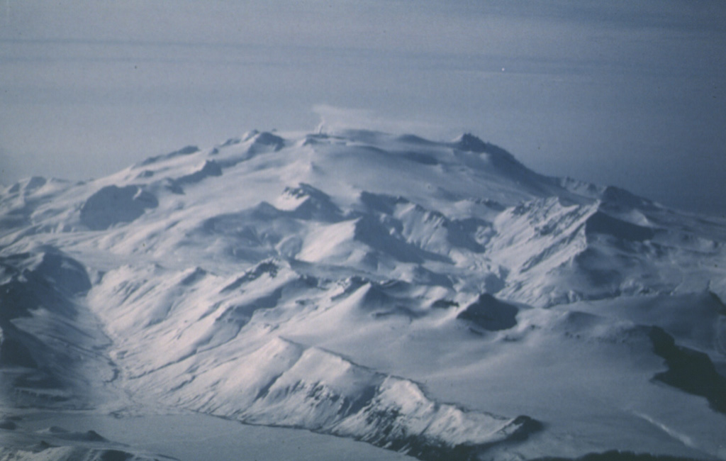
 Makushin is a glaciated volcano on northern Unalaska Island. This 2 March 1987 view from the NE shows a small plume originating from a vent on the left side of the broad summit and drifting about 3 km WNW. The summit contains a 2-km-wide caldera. Minor explosive eruptions have occurred during historical time.
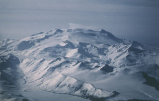
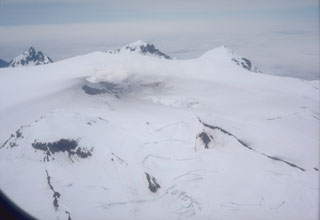 An aerial view of the summit area of Makushin volcano in the northern part of Unalaska Island in the eastern Aleutians, shows a small plume rising from a crater (left center). The broad summit contains a 2.5-km-wide Holocene caldera with a scoria cone that has produced minor explosive eruptions in historical time.
 The Point Kadin vents low on the NW flank of Makushin are a dozen or so craters and small scoria cones. They erupted along a WNW-trending fracture zone that extends to the coast.
There are no samples for Makushin in the Smithsonian's NMNH Department of Mineral Sciences Rock and Ore collection.
| Alaska Volcano Observatory (Link to Makushin) | The Alaska Volcano Observatory (AVO) is a joint program of the U.S. Geological Survey (USGS), the Geophysical Institute of the University of Alaska Fairbanks (UAFGI), and the State of Alaska Division of Geological and Geophysical Surveys (ADGGS). AVO was formed in 1988, and uses federal, state, and university resources to monitor and study Alaska's hazardous volcanoes, to predict and record eruptive activity, and to mitigate volcanic hazards to life and property. |
| Copernicus Browser | The Copernicus Browser replaced the Sentinel Hub Playground browser in 2023, to provide access to Earth observation archives from the Copernicus Data Space Ecosystem, the main distribution platform for data from the EU Copernicus missions. |
| MIROVA | Middle InfraRed Observation of Volcanic Activity (MIROVA) is a near real time volcanic hot-spot detection system based on the analysis of MODIS (Moderate Resolution Imaging Spectroradiometer) data. In particular, MIROVA uses the Middle InfraRed Radiation (MIR), measured over target volcanoes, in order to detect, locate and measure the heat radiation sourced from volcanic activity. |
| MODVOLC Thermal Alerts | Using infrared satellite Moderate Resolution Imaging Spectroradiometer (MODIS) data, scientists at the Hawai'i Institute of Geophysics and Planetology, University of Hawai'i, developed an automated system called MODVOLC to map thermal hot-spots in near real time. For each MODIS image, the algorithm automatically scans each 1 km pixel within it to check for high-temperature hot-spots. When one is found the date, time, location, and intensity are recorded. MODIS looks at every square km of the Earth every 48 hours, once during the day and once during the night, and the presence of two MODIS sensors in space allows at least four hot-spot observations every two days. Each day updated global maps are compiled to display the locations of all hot spots detected in the previous 24 hours. There is a drop-down list with volcano names which allow users to 'zoom-in' and examine the distribution of hot-spots at a variety of spatial scales. |
|
WOVOdat
Single Volcano View Temporal Evolution of Unrest Side by Side Volcanoes |
WOVOdat is a database of volcanic unrest; instrumentally and visually recorded changes in seismicity, ground deformation, gas emission, and other parameters from their normal baselines. It is sponsored by the World Organization of Volcano Observatories (WOVO) and presently hosted at the Earth Observatory of Singapore.
GVMID Data on Volcano Monitoring Infrastructure The Global Volcano Monitoring Infrastructure Database GVMID, is aimed at documenting and improving capabilities of volcano monitoring from the ground and space. GVMID should provide a snapshot and baseline view of the techniques and instrumentation that are in place at various volcanoes, which can be use by volcano observatories as reference to setup new monitoring system or improving networks at a specific volcano. These data will allow identification of what monitoring gaps exist, which can be then targeted by remote sensing infrastructure and future instrument deployments. |
| Volcanic Hazard Maps | The IAVCEI Commission on Volcanic Hazards and Risk has a Volcanic Hazard Maps database designed to serve as a resource for hazard mappers (or other interested parties) to explore how common issues in hazard map development have been addressed at different volcanoes, in different countries, for different hazards, and for different intended audiences. In addition to the comprehensive, searchable Volcanic Hazard Maps Database, this website contains information about diversity of volcanic hazard maps, illustrated using examples from the database. This site is for educational purposes related to volcanic hazard maps. Hazard maps found on this website should not be used for emergency purposes. For the most recent, official hazard map for a particular volcano, please seek out the proper institutional authorities on the matter. |
| IRIS seismic stations/networks | Incorporated Research Institutions for Seismology (IRIS) Data Services map showing the location of seismic stations from all available networks (permanent or temporary) within a radius of 0.18° (about 20 km at mid-latitudes) from the given location of Makushin. Users can customize a variety of filters and options in the left panel. Note that if there are no stations are known the map will default to show the entire world with a "No data matched request" error notice. |
| UNAVCO GPS/GNSS stations | Geodetic Data Services map from UNAVCO showing the location of GPS/GNSS stations from all available networks (permanent or temporary) within a radius of 20 km from the given location of Makushin. Users can customize the data search based on station or network names, location, and time window. Requires Adobe Flash Player. |
| DECADE Data | The DECADE portal, still in the developmental stage, serves as an example of the proposed interoperability between The Smithsonian Institution's Global Volcanism Program, the Mapping Gas Emissions (MaGa) Database, and the EarthChem Geochemical Portal. The Deep Earth Carbon Degassing (DECADE) initiative seeks to use new and established technologies to determine accurate global fluxes of volcanic CO2 to the atmosphere, but installing CO2 monitoring networks on 20 of the world's 150 most actively degassing volcanoes. The group uses related laboratory-based studies (direct gas sampling and analysis, melt inclusions) to provide new data for direct degassing of deep earth carbon to the atmosphere. |
| Large Eruptions of Makushin | Information about large Quaternary eruptions (VEI >= 4) is cataloged in the Large Magnitude Explosive Volcanic Eruptions (LaMEVE) database of the Volcano Global Risk Identification and Analysis Project (VOGRIPA). |
| EarthChem | EarthChem develops and maintains databases, software, and services that support the preservation, discovery, access and analysis of geochemical data, and facilitate their integration with the broad array of other available earth science parameters. EarthChem is operated by a joint team of disciplinary scientists, data scientists, data managers and information technology developers who are part of the NSF-funded data facility Integrated Earth Data Applications (IEDA). IEDA is a collaborative effort of EarthChem and the Marine Geoscience Data System (MGDS). |