

AVO stated that a seismic swarm beneath Kruzof Island near Edgecumbe that began at about 0200 on 11 April had declined to background levels by 22 April. The swarm prompted an in-depth analysis of satellite data which spanned the last 7.5 years. The data showed that a broad area of uplift, about 17 km in diameter, was located about 2.5 km E of Edgecumbe. The uplift began in August 2018 and deformed at a rate of up to 8.7 cm per year in the center of the area, totaling 27 cm of uplift; the deformation was ongoing. Retrospective analysis of seismic data revealed that earthquakes started occurring in 2020, though the recent swarm was unusual. The deformation and seismic data together suggested magma movement beneath the volcano, consistent with an intrusion at about 5 km below sea level. The closest seismic station to the volcano was on Sitka, 24 km E; both the Volcano Alert Level and Aviation Color Code remained at Unassigned due to the lack of dedicated, local instrumentation.
Source: US Geological Survey Alaska Volcano Observatory (AVO)
2022: April
AVO stated that a seismic swarm beneath Kruzof Island near Edgecumbe that began at about 0200 on 11 April had declined to background levels by 22 April. The swarm prompted an in-depth analysis of satellite data which spanned the last 7.5 years. The data showed that a broad area of uplift, about 17 km in diameter, was located about 2.5 km E of Edgecumbe. The uplift began in August 2018 and deformed at a rate of up to 8.7 cm per year in the center of the area, totaling 27 cm of uplift; the deformation was ongoing. Retrospective analysis of seismic data revealed that earthquakes started occurring in 2020, though the recent swarm was unusual. The deformation and seismic data together suggested magma movement beneath the volcano, consistent with an intrusion at about 5 km below sea level. The closest seismic station to the volcano was on Sitka, 24 km E; both the Volcano Alert Level and Aviation Color Code remained at Unassigned due to the lack of dedicated, local instrumentation.
Source: US Geological Survey Alaska Volcano Observatory (AVO)
AVO stated that a seismic swarm beneath Kruzof Island near Edgecumbe began at about 0200 on 11 April, and by 15 April several hundred earthquakes had been recorded. The number of events was unusual for that volcano. The magnitudes were generally M 1.7 or smaller, though a M 2.8 was detected on 11 April. The events were located at depths of less than 10 km, though the exact locations were difficult to constrain due to the lack of a local seismic network on the island; the closest station was in Sitka, 25 km E. The source of the swarm was unknown, and related either to tectonic processes or volcanic unrest, or a combination of both. Both the Volcano Alert Level and Aviation Color Code were Unassigned due to the lack of dedicated, local instrumentation. AVO noted that additional data from distant seismic stations was being analyzed, and several years of Synthetic Aperture Radar (SAR) data was being evaluated for topographical changes. No surficial changes were visible in recent satellite images and webcams views.
Source: US Geological Survey Alaska Volcano Observatory (AVO)
The Global Volcanism Program has no Bulletin Reports available for Edgecumbe.
|
|
||||||||||||||||||||||||||
There is data available for 4 confirmed Holocene eruptive periods.
2360 BCE ± 140 years - 2080 BCE ± 90 years Confirmed Eruption (Explosive / Effusive)
| Episode 1 | Eruption (Explosive / Effusive) | Edgecumbe Second Mid-Holocene Rhyolitic Ash | ||||||||||||||
|---|---|---|---|---|---|---|---|---|---|---|---|---|---|---|---|
| 2360 BCE ± 140 years - 2080 BCE ± 90 years | Evidence from Isotopic: 14C (uncalibrated) | ||||||||||||||
| The younger of two phreatomagmatic tephras from Edgecumbe is 14C dated at 4,030 ± 90 and 4,310 ± 140 BP from peat above and below the tephra (Riehle and Brew 1984; Riehle, in Wood and Kienle 1990). | |||||||||||||||
|
List of 1 Events for Episode 1 at Edgecumbe Second Mid-Holocene Rhyolitic Ash
|
|||||||||||||||
3810 BCE ± 70 years Confirmed Eruption (Explosive / Effusive)
| Episode 1 | Eruption (Explosive / Effusive) | Edgecumbe Mid-Holocene Rhyolitic Tephra | ||||||||||||||
|---|---|---|---|---|---|---|---|---|---|---|---|---|---|---|---|
| 3810 BCE ± 70 years - Unknown | Evidence from Isotopic: 14C (uncalibrated) | ||||||||||||||
| The lower of two phreatomagmatic tephras from Edgecumbe was 14C dated at 5,760 ± 70 yrs BP from peat enclosing the tephra (Riehle and Brew, 1984; Riehle et al., 1992). | |||||||||||||||
|
List of 1 Events for Episode 1 at Edgecumbe Mid-Holocene Rhyolitic Tephra
|
|||||||||||||||
7215 BCE ± 165 years Confirmed Eruption (Explosive / Effusive)
| Episode 1 | Eruption (Explosive / Effusive) | Edgecumbe CFE | ||||||||||||||||||||||||||||||||||
|---|---|---|---|---|---|---|---|---|---|---|---|---|---|---|---|---|---|---|---|---|---|---|---|---|---|---|---|---|---|---|---|---|---|---|---|
| 7215 BCE ± 165 years - Unknown | Evidence from Isotopic: 14C (uncalibrated) | ||||||||||||||||||||||||||||||||||
| 14C dates of 9,180 and 9,150 ± 150 BP from a stump within a pumice-bearing lahar deposit (Brew et al., 1969; Riehle and Brew, 1984). | |||||||||||||||||||||||||||||||||||
|
List of 5 Events for Episode 1 at Edgecumbe CFE
|
|||||||||||||||||||||||||||||||||||
9300 BCE ± 50 years Confirmed Eruption (Explosive / Effusive)
| Episode 1 | Eruption (Explosive / Effusive) | Edgecumbe Tephra set (includes Mount Edgecumbe Dacite (MEd) Tephra) | |||
|---|---|---|---|---|
| 9300 BCE ± 50 years - Unknown | Evidence from Isotopic: 14C (uncalibrated) | |||
This compilation of synonyms and subsidiary features may not be comprehensive. Features are organized into four major categories: Cones, Craters, Domes, and Thermal Features. Synonyms of features appear indented below the primary name. In some cases additional feature type, elevation, or location details are provided.
Synonyms |
||||
| Gora Edgkom | St. Hyacinthe, Mount | Saint Hyacinthe, Mount | ||||
Cones |
||||
| Feature Name | Feature Type | Elevation | Latitude | Longitude |
| Shell Mountain | Stratovolcano | 490 m | 57° 7' 34.00" N | 135° 40' 59.00" W |
Domes |
||||
| Feature Name | Feature Type | Elevation | Latitude | Longitude |
| Crater Ridge | Dome | 732 m | 57° 4' 52.00" N | 135° 42' 25.00" W |
There are no samples for Edgecumbe in the Smithsonian's NMNH Department of Mineral Sciences Rock and Ore collection.
| Alaska Volcano Observatory (Link to Edgecumbe) | The Alaska Volcano Observatory (AVO) is a joint program of the U.S. Geological Survey (USGS), the Geophysical Institute of the University of Alaska Fairbanks (UAFGI), and the State of Alaska Division of Geological and Geophysical Surveys (ADGGS). AVO was formed in 1988, and uses federal, state, and university resources to monitor and study Alaska's hazardous volcanoes, to predict and record eruptive activity, and to mitigate volcanic hazards to life and property. |
| Copernicus Browser | The Copernicus Browser replaced the Sentinel Hub Playground browser in 2023, to provide access to Earth observation archives from the Copernicus Data Space Ecosystem, the main distribution platform for data from the EU Copernicus missions. |
| MIROVA | Middle InfraRed Observation of Volcanic Activity (MIROVA) is a near real time volcanic hot-spot detection system based on the analysis of MODIS (Moderate Resolution Imaging Spectroradiometer) data. In particular, MIROVA uses the Middle InfraRed Radiation (MIR), measured over target volcanoes, in order to detect, locate and measure the heat radiation sourced from volcanic activity. |
| MODVOLC Thermal Alerts | Using infrared satellite Moderate Resolution Imaging Spectroradiometer (MODIS) data, scientists at the Hawai'i Institute of Geophysics and Planetology, University of Hawai'i, developed an automated system called MODVOLC to map thermal hot-spots in near real time. For each MODIS image, the algorithm automatically scans each 1 km pixel within it to check for high-temperature hot-spots. When one is found the date, time, location, and intensity are recorded. MODIS looks at every square km of the Earth every 48 hours, once during the day and once during the night, and the presence of two MODIS sensors in space allows at least four hot-spot observations every two days. Each day updated global maps are compiled to display the locations of all hot spots detected in the previous 24 hours. There is a drop-down list with volcano names which allow users to 'zoom-in' and examine the distribution of hot-spots at a variety of spatial scales. |
|
WOVOdat
Single Volcano View Temporal Evolution of Unrest Side by Side Volcanoes |
WOVOdat is a database of volcanic unrest; instrumentally and visually recorded changes in seismicity, ground deformation, gas emission, and other parameters from their normal baselines. It is sponsored by the World Organization of Volcano Observatories (WOVO) and presently hosted at the Earth Observatory of Singapore.
GVMID Data on Volcano Monitoring Infrastructure The Global Volcano Monitoring Infrastructure Database GVMID, is aimed at documenting and improving capabilities of volcano monitoring from the ground and space. GVMID should provide a snapshot and baseline view of the techniques and instrumentation that are in place at various volcanoes, which can be use by volcano observatories as reference to setup new monitoring system or improving networks at a specific volcano. These data will allow identification of what monitoring gaps exist, which can be then targeted by remote sensing infrastructure and future instrument deployments. |
| Volcanic Hazard Maps | The IAVCEI Commission on Volcanic Hazards and Risk has a Volcanic Hazard Maps database designed to serve as a resource for hazard mappers (or other interested parties) to explore how common issues in hazard map development have been addressed at different volcanoes, in different countries, for different hazards, and for different intended audiences. In addition to the comprehensive, searchable Volcanic Hazard Maps Database, this website contains information about diversity of volcanic hazard maps, illustrated using examples from the database. This site is for educational purposes related to volcanic hazard maps. Hazard maps found on this website should not be used for emergency purposes. For the most recent, official hazard map for a particular volcano, please seek out the proper institutional authorities on the matter. |
| IRIS seismic stations/networks | Incorporated Research Institutions for Seismology (IRIS) Data Services map showing the location of seismic stations from all available networks (permanent or temporary) within a radius of 0.18° (about 20 km at mid-latitudes) from the given location of Edgecumbe. Users can customize a variety of filters and options in the left panel. Note that if there are no stations are known the map will default to show the entire world with a "No data matched request" error notice. |
| UNAVCO GPS/GNSS stations | Geodetic Data Services map from UNAVCO showing the location of GPS/GNSS stations from all available networks (permanent or temporary) within a radius of 20 km from the given location of Edgecumbe. Users can customize the data search based on station or network names, location, and time window. Requires Adobe Flash Player. |
| DECADE Data | The DECADE portal, still in the developmental stage, serves as an example of the proposed interoperability between The Smithsonian Institution's Global Volcanism Program, the Mapping Gas Emissions (MaGa) Database, and the EarthChem Geochemical Portal. The Deep Earth Carbon Degassing (DECADE) initiative seeks to use new and established technologies to determine accurate global fluxes of volcanic CO2 to the atmosphere, but installing CO2 monitoring networks on 20 of the world's 150 most actively degassing volcanoes. The group uses related laboratory-based studies (direct gas sampling and analysis, melt inclusions) to provide new data for direct degassing of deep earth carbon to the atmosphere. |
| Large Eruptions of Edgecumbe | Information about large Quaternary eruptions (VEI >= 4) is cataloged in the Large Magnitude Explosive Volcanic Eruptions (LaMEVE) database of the Volcano Global Risk Identification and Analysis Project (VOGRIPA). |
| EarthChem | EarthChem develops and maintains databases, software, and services that support the preservation, discovery, access and analysis of geochemical data, and facilitate their integration with the broad array of other available earth science parameters. EarthChem is operated by a joint team of disciplinary scientists, data scientists, data managers and information technology developers who are part of the NSF-funded data facility Integrated Earth Data Applications (IEDA). IEDA is a collaborative effort of EarthChem and the Marine Geoscience Data System (MGDS). |
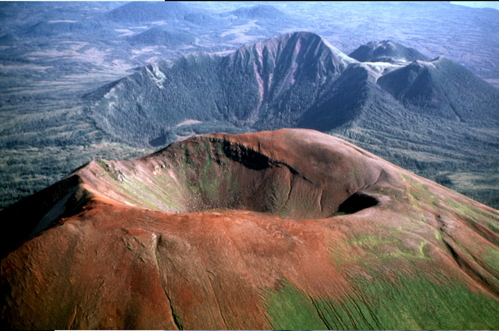
 The Pleistocene-to-Holocene Mount Edgecumbe volcanic field covers about 260 km2 of Kruzov Island west of Sitka in the SE panhandle of Alaska. This aerial view shows oxidized scoria of the Edgecumbe volcano in the foreground. Crater Ridge in the background contains a 1.6-km-wide, 240-m deep caldera. And rhyolite domes (top right) The youngest eruptions from Mount Edgecumbe, the largest feature in the Edgecumbe field, are about 4,000 years old.