The Global Volcanism Program has no activity reports available for Edziza.
The Global Volcanism Program has no Weekly Reports available for Edziza.
The Global Volcanism Program has no Bulletin Reports available for Edziza.
|
|
||||||||||||||||||||||||||||
There is data available for 4 confirmed eruptive periods.
0950 ± 6000 years Confirmed Eruption (Explosive / Effusive) VEI: 3
| Episode 1 | Eruption (Explosive / Effusive) | SW flank of Ice Peak, Sheep Track Pumice | ||||||||||||||||||||||||||||
|---|---|---|---|---|---|---|---|---|---|---|---|---|---|---|---|---|---|---|---|---|---|---|---|---|---|---|---|---|---|
| 0950 ± 6000 years - Unknown | Evidence from Radiogenic: Fission track | ||||||||||||||||||||||||||||
| An eruption from a vent on the SW flank of Ice Peak, now covered by the Tencho Glacier, produced the rhyolitic Sheep Track Pumice and a small flow (Souther and Lambert, 1972; Souther, 1992). A fission track date of 1,000 ± 6,000 BP (Aumento & Souther, 1973) is consistent with the stratigraphic position of the Sheep Track Pumice, which overlies lava flows of all but one vent of the Snowshoe Lava Field of the Big Raven Formation. The Sheep Track Pumice could predate some Big Raven Formation lava flows to the north, beyond its area of deposition (Souther, 1992). | |||||||||||||||||||||||||||||
|
List of 4 Events for Episode 1 at SW flank of Ice Peak, Sheep Track Pumice
|
|||||||||||||||||||||||||||||
0630 ± 150 years Confirmed Eruption (Explosive / Effusive)
| Episode 1 | Eruption (Explosive / Effusive) | NNE flank (Williams Cone) | ||||||||||||||||||||||||||||
|---|---|---|---|---|---|---|---|---|---|---|---|---|---|---|---|---|---|---|---|---|---|---|---|---|---|---|---|---|---|
| 0630 ± 150 years - Unknown | Evidence from Isotopic: 14C (uncalibrated) | ||||||||||||||||||||||||||||
| A 14C age of 1,340 ± 130 BP was obtained from charred twigs beneath a basaltic tephra from Williams Cone (Souther, 1992); at least three younger units are present (Souther, 1972; Souther and Lambert, 1972). The 14C date has also been reported as 1,320 and 1,300 BP. The eruption formed a 275-m-high cinder cone; lava flows from Williams Cone traveled 13 km NE to the Klastline River. | |||||||||||||||||||||||||||||
|
List of 4 Events for Episode 1 at NNE flank (Williams Cone)
|
|||||||||||||||||||||||||||||
0750 BCE ± 100 years Confirmed Eruption (Explosive / Effusive)
| Episode 1 | Eruption (Explosive / Effusive) | ||||||||||||||
|---|---|---|---|---|---|---|---|---|---|---|---|---|---|---|
| 0750 BCE ± 100 years - Unknown | Evidence from Correlation: Tephrochronology | |||||||||||||
| Ten subglacial lava flows were probably erupted during a major readvance of alpine glaciers around 2,600-2,800 BP (Souther and Symons, 1974). | ||||||||||||||
|
List of 1 Events for Episode 1
|
||||||||||||||
6520 BCE ± 200 years Confirmed Eruption (Explosive / Effusive)
| Episode 1 | Eruption (Explosive / Effusive) | North flank? | |||||||||||||
|---|---|---|---|---|---|---|---|---|---|---|---|---|---|---|
| 6520 BCE ± 200 years - Unknown | Evidence from Isotopic: 14C (uncalibrated) | |||||||||||||
| Basaltic lava flows capping terraces in the Klastline Valley are believed correlate with older flows of the Big Raven Formation. Paleosols beneath the flows are 14C dated at 8,350, 8,440, and 8,610 ± 80 years BP (Souther, 1992). | ||||||||||||||
|
List of 1 Events for Episode 1 at North flank?
|
||||||||||||||
This compilation of synonyms and subsidiary features may not be comprehensive. Features are organized into four major categories: Cones, Craters, Domes, and Thermal Features. Synonyms of features appear indented below the primary name. In some cases additional feature type, elevation, or location details are provided.
Cones |
||||
| Feature Name | Feature Type | Elevation | Latitude | Longitude |
| Armadillo Peak | Stratovolcano | 2194 m | 57° 32' 0.00" N | 130° 33' 0.00" W |
| Cache Hill | Shield volcano | 2110 m | 57° 32' 0.00" N | 130° 40' 0.00" W |
| Camp Hill | Shield volcano | 1880 m | 57° 35' 0.00" N | 130° 47' 0.00" W |
| Cinder Cliff | Cone | 1800 m | 57° 45' 0.00" N | 130° 34' 0.00" W |
| Desolation Lava Field | Vent | 2165 m | 57° 49' 0.00" N | 130° 37' 0.00" W |
| Eve | Pyroclastic cone | 1740 m | 57° 49' 0.00" N | 130° 40' 0.00" W |
| Ice Peak | Stratovolcano | 2500 m | 57° 42' 0.00" N | 130° 38' 0.00" W |
| Icefall | Cone | 2285 m | 57° 42' 0.00" N | 130° 36' 0.00" W |
| Kana | Cone | 1100 m | 57° 54' 0.00" N | 130° 37' 0.00" W |
| Keda | Cone | 1980 m | 57° 36' 0.00" N | 130° 41' 0.00" W |
| Klastline | Cone | 1400 m | 57° 47' 0.00" N | 130° 30' 0.00" W |
| Moraine | Cone | 2135 m | 57° 46' 0.00" N | 130° 37' 0.00" W |
| Neck, the | Cone | 1830 m | 57° 40' 0.00" N | 130° 35' 0.00" W |
| Pillow Ridge | Vent | 2400 m | 57° 46' 0.00" N | 130° 38' 0.00" W |
| Ridge | Cone | 2285 m | 57° 41' 0.00" N | 130° 37' 0.00" W |
| Saucer, the | Cone | 1920 m | 57° 38' 0.00" N | 130° 38' 0.00" W |
| Sidas | Cone | 1540 m | 57° 52' 0.00" N | 130° 38' 0.00" W |
| Sleet | Cone | 1783 m | 57° 47' 0.00" N | 130° 33' 0.00" W |
| Snowshoe Lava Field | Vent | 2350 m | 57° 39' 0.00" N | 130° 40' 0.00" W |
| Storm | Cone | 2135 m | 57° 46' 0.00" N | 130° 38' 0.00" W |
| Tennena | Cone | 2350 m | 57° 41' 0.00" N | 130° 40' 0.00" W |
| Triplex | Cone | 1785 m | 57° 48' 0.00" N | 130° 37' 0.00" W |
| Tsekone Ridge | Vent | 1920 m | 57° 46' 0.00" N | 130° 41' 0.00" W |
| Twin | Cone | 1430 m | 57° 48' 0.00" N | 130° 32' 0.00" W |
| Walkout Creek | Cone | 1550 m | 57° 35' 0.00" N | 130° 45' 0.00" W |
| Williams | Pyroclastic cone | 2100 m | 57° 47' 0.00" N | 130° 36' 0.00" W |
Craters |
||||
| Feature Name | Feature Type | Elevation | Latitude | Longitude |
| Cocoa | Crater - Cone | 2117 m | 57° 39' 0.00" N | 130° 42' 0.00" W |
| Coffee | Crater - Cone | 2000 m | 57° 38' 0.00" N | 130° 40' 0.00" W |
Domes |
||||
| Feature Name | Feature Type | Elevation | Latitude | Longitude |
| Glacier | Dome | 2225 m | 57° 46' 0.00" N | 130° 35' 0.00" W |
| Nanook | Dome | 2710 m | 57° 43' 0.00" N | 130° 36' 0.00" W |
| Pharaoh | Dome | 2200 m | 57° 39' 0.00" N | 130° 36' 0.00" W |
| Pyramid | Dome | 2199 m | 57° 46' 0.00" N | 130° 34' 0.00" W |
| Sphinx | Dome | 2380 m | 57° 45' 0.00" N | 130° 35' 0.00" W |
| Triangle | Dome | 2680 m | 57° 43' 0.00" N | 130° 39' 0.00" W |
Thermal |
||||
| Feature Name | Feature Type | Elevation | Latitude | Longitude |
| Elwyn Hot Springs | Hot Spring | 1440 m | 57° 46' 0.00" N | 130° 45' 0.00" W |
| Taweh Hot Springs | Hot Spring | 1310 m | 57° 41' 0.00" N | 130° 46' 0.00" W |
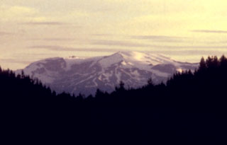 The Mount Edziza complex, seen here from the east along the Cassiar-Stewart Highway, is part of a large volcanic plateau that is the centerpiece of Mount Edziza Provincial Park, one of the largest in British Columbia. The complex was constructed over the past 7.5 million years during five cycles beginning with eruption of alkali basalts and ending with felsic and basaltic eruptions as late about 1,000 years ago. Numerous ice-contact features and products of subglacial eruptions are found in the Mount Edziza complex.
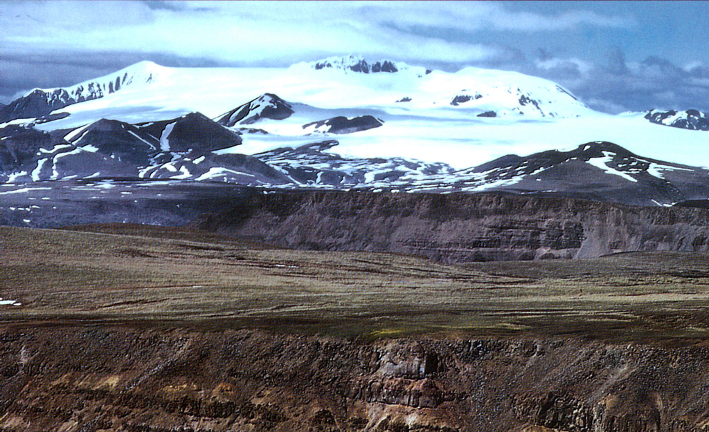
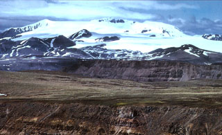 The central ice-covered summit complex of Mount Edziza is seen here from the SW rising above the Kitsu and Big Raven plateaus. Late-Tertiary lava flows are the foreground. The smaller hills at the base of the icecap are Quaternary cones. Mount Edziza contains a 2-km-wide, ice-filled caldera at its summit, and numerous ice-contact features and products of subglacial eruptions. The complex contains numerous Holocene cones, some of which are younger than about 1,300 years.
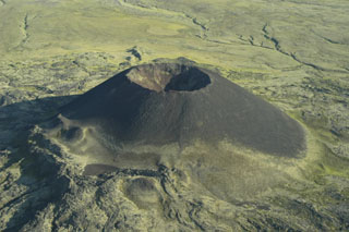 Scoria cones, such as Eve Cone on the flank of Edziza volcano, are formed by the explosive ejection of fragmental material that accumulated around the vent. This symmetrical cone is part of the Desolation Lava Field on the northern flank of Edziza and is one of the youngest features of the volcano. Basaltic lava flows erupted from the base of the cone, which reaches about 150 m high and has a 45-m-deep crater.
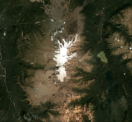 Mount Edziza is an approximately 30-km-long volcanic range that forms the northernmost edifice of the Mount Edziza volcanic complex, and is shown in this July 2018 Planet Labs satellite image monthly mosaic (N is at the top; this image is approximately 42 km across). Many eruptions occurred within ice and water, such as the Tennena cone on the western flank about two-thirds down the ice cap in this view, forming pillow lavas and hydrovolcanic clastic deposits.
There are no samples for Edziza in the Smithsonian's NMNH Department of Mineral Sciences Rock and Ore collection.
| Copernicus Browser | The Copernicus Browser replaced the Sentinel Hub Playground browser in 2023, to provide access to Earth observation archives from the Copernicus Data Space Ecosystem, the main distribution platform for data from the EU Copernicus missions. |
| MIROVA | Middle InfraRed Observation of Volcanic Activity (MIROVA) is a near real time volcanic hot-spot detection system based on the analysis of MODIS (Moderate Resolution Imaging Spectroradiometer) data. In particular, MIROVA uses the Middle InfraRed Radiation (MIR), measured over target volcanoes, in order to detect, locate and measure the heat radiation sourced from volcanic activity. |
| MODVOLC Thermal Alerts | Using infrared satellite Moderate Resolution Imaging Spectroradiometer (MODIS) data, scientists at the Hawai'i Institute of Geophysics and Planetology, University of Hawai'i, developed an automated system called MODVOLC to map thermal hot-spots in near real time. For each MODIS image, the algorithm automatically scans each 1 km pixel within it to check for high-temperature hot-spots. When one is found the date, time, location, and intensity are recorded. MODIS looks at every square km of the Earth every 48 hours, once during the day and once during the night, and the presence of two MODIS sensors in space allows at least four hot-spot observations every two days. Each day updated global maps are compiled to display the locations of all hot spots detected in the previous 24 hours. There is a drop-down list with volcano names which allow users to 'zoom-in' and examine the distribution of hot-spots at a variety of spatial scales. |
|
WOVOdat
Single Volcano View Temporal Evolution of Unrest Side by Side Volcanoes |
WOVOdat is a database of volcanic unrest; instrumentally and visually recorded changes in seismicity, ground deformation, gas emission, and other parameters from their normal baselines. It is sponsored by the World Organization of Volcano Observatories (WOVO) and presently hosted at the Earth Observatory of Singapore.
GVMID Data on Volcano Monitoring Infrastructure The Global Volcano Monitoring Infrastructure Database GVMID, is aimed at documenting and improving capabilities of volcano monitoring from the ground and space. GVMID should provide a snapshot and baseline view of the techniques and instrumentation that are in place at various volcanoes, which can be use by volcano observatories as reference to setup new monitoring system or improving networks at a specific volcano. These data will allow identification of what monitoring gaps exist, which can be then targeted by remote sensing infrastructure and future instrument deployments. |
| Volcanic Hazard Maps | The IAVCEI Commission on Volcanic Hazards and Risk has a Volcanic Hazard Maps database designed to serve as a resource for hazard mappers (or other interested parties) to explore how common issues in hazard map development have been addressed at different volcanoes, in different countries, for different hazards, and for different intended audiences. In addition to the comprehensive, searchable Volcanic Hazard Maps Database, this website contains information about diversity of volcanic hazard maps, illustrated using examples from the database. This site is for educational purposes related to volcanic hazard maps. Hazard maps found on this website should not be used for emergency purposes. For the most recent, official hazard map for a particular volcano, please seek out the proper institutional authorities on the matter. |
| IRIS seismic stations/networks | Incorporated Research Institutions for Seismology (IRIS) Data Services map showing the location of seismic stations from all available networks (permanent or temporary) within a radius of 0.18° (about 20 km at mid-latitudes) from the given location of Edziza. Users can customize a variety of filters and options in the left panel. Note that if there are no stations are known the map will default to show the entire world with a "No data matched request" error notice. |
| UNAVCO GPS/GNSS stations | Geodetic Data Services map from UNAVCO showing the location of GPS/GNSS stations from all available networks (permanent or temporary) within a radius of 20 km from the given location of Edziza. Users can customize the data search based on station or network names, location, and time window. Requires Adobe Flash Player. |
| DECADE Data | The DECADE portal, still in the developmental stage, serves as an example of the proposed interoperability between The Smithsonian Institution's Global Volcanism Program, the Mapping Gas Emissions (MaGa) Database, and the EarthChem Geochemical Portal. The Deep Earth Carbon Degassing (DECADE) initiative seeks to use new and established technologies to determine accurate global fluxes of volcanic CO2 to the atmosphere, but installing CO2 monitoring networks on 20 of the world's 150 most actively degassing volcanoes. The group uses related laboratory-based studies (direct gas sampling and analysis, melt inclusions) to provide new data for direct degassing of deep earth carbon to the atmosphere. |
| Large Eruptions of Edziza | Information about large Quaternary eruptions (VEI >= 4) is cataloged in the Large Magnitude Explosive Volcanic Eruptions (LaMEVE) database of the Volcano Global Risk Identification and Analysis Project (VOGRIPA). |
| EarthChem | EarthChem develops and maintains databases, software, and services that support the preservation, discovery, access and analysis of geochemical data, and facilitate their integration with the broad array of other available earth science parameters. EarthChem is operated by a joint team of disciplinary scientists, data scientists, data managers and information technology developers who are part of the NSF-funded data facility Integrated Earth Data Applications (IEDA). IEDA is a collaborative effort of EarthChem and the Marine Geoscience Data System (MGDS). |

