Canada Volcanoes

Canada has 24 Holocene volcanoes. Note that as a scientific organization we provide these listings for informational purposes only, with no international legal or policy implications. Volcanoes will be included on this list if they are within the boundaries of a country, on a shared boundary or area, in a remote territory, or within a maritime Exclusive Economic Zone. Bolded volcanoes have erupted within the past 20 years. Suggestions and data updates are always welcome ().
| Volcano Name | Last Eruption | Volcanic Region | Primary Landform |
|---|---|---|---|
| Alligator Lake | Unknown - Evidence Credible | Northern Cordilleran Volcanic Province | Cluster |
| Atlin Volcanic Field | Unknown - Evidence Credible | Northern Cordilleran Volcanic Province | Cluster |
| Bridge River Cones | Unknown - Evidence Credible | Garibaldi Volcanic Arc | Cluster |
| Cayley Volcanic Field | Unknown - Evidence Credible | Garibaldi Volcanic Arc | Cluster |
| Cobb Segment | 1180 BCE | Northeast Pacific Rifts Volcanic Province | Cluster |
| Crow Lagoon | Unknown - Evidence Credible | Northern Cordilleran Volcanic Province | Minor |
| Edziza | 950 CE | Northern Cordilleran Volcanic Province | Composite |
| Endeavour Segment | 3490 BCE | Northeast Pacific Rifts Volcanic Province | Cluster |
| Fort Selkirk | Unknown - Evidence Uncertain | Northern Cordilleran Volcanic Province | Cluster |
| Garibaldi | 8060 BCE | Garibaldi Volcanic Arc | Composite |
| Garibaldi Lake | Unknown - Evidence Credible | Garibaldi Volcanic Arc | Cluster |
| Heart Peaks | Unknown - Evidence Uncertain | Northern Cordilleran Volcanic Province | Shield |
| Hoodoo Mountain | 7050 BCE | Northern Cordilleran Volcanic Province | Minor |
| Iskut-Unuk River Cones | 1800 CE | Northern Cordilleran Volcanic Province | Cluster |
| Level Mountain | Unknown - Evidence Uncertain | Northern Cordilleran Volcanic Province | Shield |
| Meager | 410 BCE | Garibaldi Volcanic Arc | Composite |
| Milbanke Sound Group | Unknown - Evidence Credible | Queen Charlotte Volcano Group | Minor (Basaltic) |
| Nazko | 5220 BCE | Interior Western Canada Volcanic Province | Minor (Basaltic) |
| Silverthrone | Unknown - Evidence Credible | Garibaldi Volcanic Arc | Composite |
| Spectrum Range | Unknown - Evidence Credible | Northern Cordilleran Volcanic Province | Shield |
| Tseax River Cone | 1690 CE | Northern Cordilleran Volcanic Province | Minor (Basaltic) |
| Tuya Volcanic Field | Unknown - Evidence Credible | Northern Cordilleran Volcanic Province | Cluster |
| Wells Gray-Clearwater | 1550 CE | Interior Western Canada Volcanic Province | Cluster |
| West Valley Segment | Unknown - Unrest / Holocene | Northeast Pacific Rifts Volcanic Province | Cluster |
Chronological listing of known Holocene eruptions (confirmed or uncertain) from volcanoes in Canada. Bolded eruptions indicate continuing activity.
| Volcano Name | Start Date | Stop Date | Certainty | VEI | Evidence |
|---|---|---|---|---|---|
| Iskut-Unuk River Cones | [1904] | [Unknown] | Uncertain | ||
| Atlin Volcanic Field | [1898 Nov 8] | [Unknown] | Uncertain | ||
| Iskut-Unuk River Cones | 1800 (?) | Unknown | Confirmed | Isotopic: 14C (uncalibrated) | |
| Tseax River Cone | 1690 ± 150 years | Unknown | Confirmed | Isotopic: 14C (calibrated) | |
| Iskut-Unuk River Cones | 1590 ± 50 years | Unknown | Confirmed | Isotopic: 14C (uncalibrated) | |
| Wells Gray-Clearwater | 1550 (?) | Unknown | Confirmed | Sidereal: Dendrochronology | |
| Tseax River Cone | 1330 ± 75 years | Unknown | Confirmed | Isotopic: 14C (uncalibrated) | |
| Edziza | 0950 ± 6000 years | Unknown | Confirmed | 3 | Radiogenic: Fission track |
| Edziza | 0630 ± 150 years | Unknown | Confirmed | Isotopic: 14C (uncalibrated) | |
| Meager | 0410 BCE ± 200 years | Unknown | Confirmed | 5 | Isotopic: 14C (calibrated) |
| Iskut-Unuk River Cones | 0620 BCE ± 150 years | Unknown | Confirmed | Isotopic: 14C (uncalibrated) | |
| Edziza | 0750 BCE ± 100 years | Unknown | Confirmed | Correlation: Tephrochronology | |
| Cobb Segment | 1180 BCE (?) | Unknown | Confirmed | 1 | Isotopic: Uranium-series |
| Iskut-Unuk River Cones | 1830 BCE ± 300 years | Unknown | Confirmed | Isotopic: 14C (uncalibrated) | |
| Iskut-Unuk River Cones | 3450 BCE ± 150 years | Unknown | Confirmed | Isotopic: 14C (uncalibrated) | |
| Endeavour Segment | 3490 BCE (?) | Unknown | Confirmed | 0 | Isotopic: Uranium-series |
| Iskut-Unuk River Cones | 4700 BCE ± 300 years | Unknown | Confirmed | Isotopic: 14C (uncalibrated) | |
| Nazko | 5220 BCE ± 100 years | Unknown | Confirmed | Isotopic: 14C (uncalibrated) | |
| Wells Gray-Clearwater | 5650 BCE (?) | Unknown | Confirmed | Isotopic: 14C (uncalibrated) | |
| Edziza | 6520 BCE ± 200 years | Unknown | Confirmed | Isotopic: 14C (uncalibrated) | |
| Iskut-Unuk River Cones | 6830 BCE ± 150 years | Unknown | Confirmed | Isotopic: 14C (uncalibrated) | |
| Endeavour Segment | 6930 BCE (?) | Unknown | Confirmed | 0 | Isotopic: Uranium-series |
| Hoodoo Mountain | 7050 BCE (?) | Unknown | Confirmed | 0 | Correlation: Tephrochronology |
| Garibaldi | 8060 BCE ± 500 years | Unknown | Confirmed | 3 | Isotopic: 14C (uncalibrated) |
Canada has 14 Pleistocene volcanoes. Note that as a scientific organization we provide these listings for informational purposes only, with no international legal or policy implications. Volcanoes will be included on this list if they are within the boundaries of a country, on a shared boundary or area, in a remote territory, or within a maritime Exclusive Economic Zone. Suggestions and data updates are always welcome ().
| Volcano Name | Volcanic Region | Primary Landform |
|---|---|---|
| Alice Arm | Northern Cordilleran Volcanic Province | Cluster |
| Baldface Mountain | Interior Western Canada Volcanic Province | Cluster |
| Bowie Seamount | Kodiak-Bowie Hotspot Volcano Group | Minor |
| Chilcotin Group-North | Interior Western Canada Volcanic Province | Cluster |
| Chilcotin Group-South | Interior Western Canada Volcanic Province | Cluster |
| Dark Mountain | Northern Cordilleran Volcanic Province | Cluster |
| Hogum Range | Northern Cordilleran Volcanic Province | Cluster |
| Itcha Range | Interior Western Canada Volcanic Province | Cluster |
| Kawdy Metah | Northern Cordilleran Volcanic Province | Cluster |
| Klastline Group | Northern Cordilleran Volcanic Province | Cluster |
| Quesnel Cone Group | Interior Western Canada Volcanic Province | Minor |
| Satah Mountain | Interior Western Canada Volcanic Province | Cluster |
| Squamish | Garibaldi Volcanic Arc | Cluster |
| Tuzo Wilson Knolls | Kodiak-Bowie Hotspot Volcano Group | Minor |
There are 38 photos available for volcanoes in Canada.
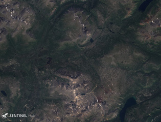
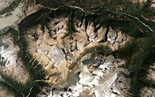
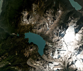 Garibaldi Lake is a group of nine cones around the lake in the center of this October 2020 Planet Labs satellite image monthly mosaic (N is at the top; this image is approximately 16.5 km across). The three cones SW of the lake center are Price Bay, Mount Price, and Clinker Peak. The Black Husk is the dark cone about 2.5-3 km N of the upper part of the lake, and The Cinder Cone is 2.5 km SE of that.
Satellite image courtesy of Planet Labs Inc., 2020 (https://www.planet.com/).
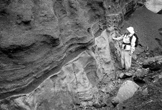
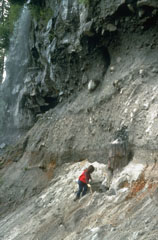 The tree trunk next to the geologist was buried by ash deposits from the Bridge River eruption of the Meager volcanic complex about 2,350 years ago, which was then covered by a pyroclastic flow. The deposit has an unwelded base and a darker, more massive welded layer at the top of this photo.
Photo by Willie Scott, 1990 (U.S. Geological Survey).
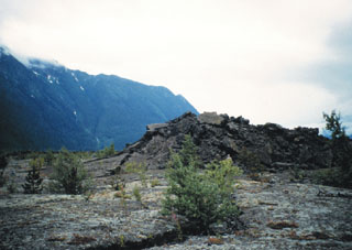
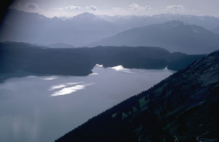 The low ridge in the center of the photo consists of early Holocene lava flows that originated from Clinker Peak on Mount Price to the south (out of view to the left). The lava flows ponded against the retreating continental glacier that filled the Cheakamus River valley to a depth of 1 km and formed a barrier that created Garibaldi Lake.
Photo by Lee Siebert, 1983 (Smithsonian Institution).
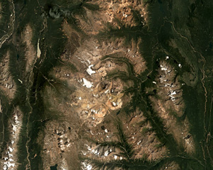
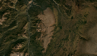
 The heavily eroded Cayley Volcanic Field in SW Canada is the N-S trending ridge down the center of this August 2019 Planet Labs satellite image monthly mosaic (N is at the top; this image is approximately 69 km across). The complex is composed of different eruption centers including lava domes, cones, and glaciovolcanic features, and has also been shaped by large flank collapse events.
Satellite image courtesy of Planet Labs Inc., 2019 (https://www.planet.com/).
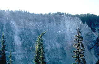 The cliff along Rubble Creek is the margin of the early Holocene lava flows that formed Garibaldi Lake. The steep lava flow margin formed when the flow ponded against the retreating continental glacier filling the Cheakamus River valley. This has been the source of several landslides down Rubble Creek, leaving a scarp known as The Barrier.
Photo by Lee Siebert, 1983 (Smithsonian Institution).
 The Spectrum Range is located south of Mount Edziza within the Mount Edziza-Spectrum Range volcanic complex, shown in this July 2018 Planet Labs satellite image monthly mosaic (N is at the top; this image is approximately 48 km across). The edifice is deeply eroded and largely consists of rhyolite domes. The Mess Lake Lava Field is the darker brown area NW of the lighter-colored domes.
Satellite image courtesy of Planet Labs Inc., 2018 (https://www.planet.com/).
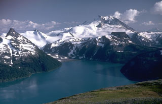
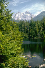
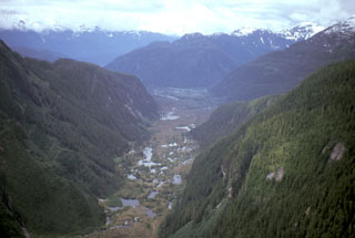
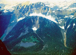
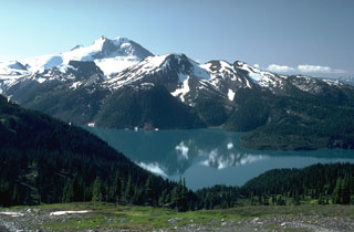 The Garibaldi Lake volcanic field consists of nine small stratovolcanoes and vents of Pleistocene to Holocene age around Garibaldi Lake, seen here with Mount Garibaldi in the background. Mount Price, in the center of the photo, is a small andesitic stratovolcano. Clinker Peak on the west flank produced two Holocene lava flows that dammed Rubble Creek at the right-hand margin of this photo, forming Garibaldi Lake.
Photo by Lee Siebert, 1983 (Smithsonian Institution).
 Mount Garibaldi, rising above Garibaldi Lake to the north, is a largely Pleistocene stratovolcano with a summit lava dome complex. The volcano was partially constructed over the Cordilleran ice sheet and contains many ice-contact features. Its final eruptions during the early Holocene included lava flows that mantled the western landside scarp and a massive lava flow from Opal Cone, a SE flank vent, that traveled 20 km to the south and west.
Photo by Lee Siebert, 1983 (Smithsonian Institution).
 The Milbanke Sound Group contains several cones, with the best preserved Kitasu Hill scoria cone on Swindle Island in the center of this July 2018 Planet Labs satellite image monthly mosaic (N is at the top; this image is approximately 15 km across). Nearby Lake Island and Lady Douglas Island also contain cones and lava flows.
Satellite image courtesy of Planet Labs Inc., 2018 (https://www.planet.com/).
 Alligator lake is in the lower right corner of this 24 July 2018 Sentinel-2 satellite image (N is at the top; this image is approximately 31 km across). The Alligator Lake volcanic complex contains cones and lava flows with the Ibex Mountain Cone to the NW (in the center of the top of this image).
Satellite image courtesy of Copernicus Sentinel Data, 2018.
 A geologist observes the contact between a basaltic Plinian fallout lapilli unit overlying marine clay. This deposit is part of thick beds of basaltic Holocene tephra originating from an unknown Quaternary volcanic center found near Crow Lagoon, north of Prince Rupert near the southern tip of the Alaskan panhandle. Ballistically emplaced bombs imply a nearby source. The tephra beds are located along the south side of the Khutzeymateen Inlet, about 40 km N of Prince Rupert.
Photo by Jack Souther (Geological Survey of Canada, courtesy of Cathie Hickson).
 The Pleistocene Mount Garibaldi was partially constructed over the Cordilleran ice sheet. Its western face, seen from near Alice Lake, exposes the interior structure of the volcano and resulted from repeated landslides from the steep slope remaining from when the continental ice sheet retreated. The summit peak to the right is Atwell Peak and the rounded peak to the left is Dalton Dome, the source of some of Garibaldi's most recent eruptions.
Photo by Lee Siebert, 1976 (Smithsonian Institution).
 South Tuya, seen here from the north, is one of six subglacial volcanoes close to Tuya Lake, in north-central British Columbia. The cone seen above comprises loose volcanic debris as well as dikes of basaltic rock intruded into the volcanic pile. The base of the volcano comprises pillow lavas and hyaloclastite, indicating that the volcano formed either beneath ice or within a large lake. Several small postglacial cones and lava flows have been reported in this area.
Photo by Ben Edwards, 2003 (Dickinson College, Pennsylvania).
 The Table, the flat-topped ridge in the foreground in front of Mount Garibaldi, is the southernmost vent of the Garibaldi Lake volcanic field. This is a tuya that formed when lava flows filled a pit melted through the continental ice sheet. A series of stacked horizontal lava flows filling the pit formed The Table.
 Photo by Lee Siebert, 1983 (Smithsonian Institution).
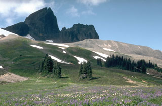 Black Tusk is a glacially eroded lava dome from the earliest stage of activity of the Garibaldi Lake volcanic field about 1 million years ago. The light-colored ridge to the right is a glacial moraine.
Photo by Lee Siebert, 1983 (Smithsonian Institution).
 Cracker Creek cone (center), the small vegetated hill seen here from the west, is the youngest feature of the Atlin Volcanic Field on the Teslin Plateau in NW British Columbia. The small scoria cone lies at the head of Cracker Creek, immediately east of Ruby Mountain volcano, and may have been the source of a large lava flow that partly filled Ruby Creek. The lower west side of the cone appears to be partly covered by glacial till, suggesting that the cone is older than the most recent glacial advances down Ruby Creek.
Photo by Ben Edwards, 2000 (Dickinson College, Pennsylvania).
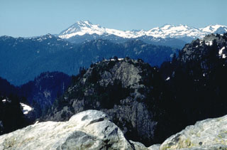
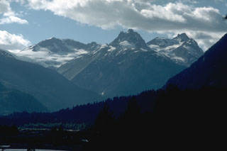
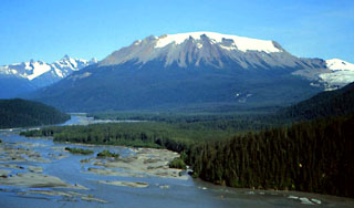
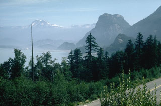 Mount Garibaldi rises above Howe Sound, 80 km N of Vancouver. The steep-sided peak on the right is the Squamish Chief, a glacially eroded peak of the Coast Range batholith. Garibaldi was constructed during the Pleistocene, partially overriding the Cordilleran ice sheet. Retreat of the ice sheet left the western side of the volcano unsupported, causing many landslides into the Cheakamus River valley.
Photo by Lee Siebert, 1976 (Smithsonian Institution).
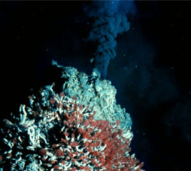 This 360°C black smoker chimney is located in the Endeavour Ridge segment of the Main Endeavour hydrothermal field at the northern end of the Juan de Fuca Ridge. Tube worms with red gills thrive on the edifice, which is predominantly composed of iron- and sulfur-bearing minerals. The 90-km-long ridge segment, which lies west of the coast of Washington and SW of Vancouver Island, is the site of vigorous high-temperature hydrothermal vent systems that were first discovered by scientists in 1981.
Image courtesy of NOAA Ocean Explorer and University of Washington.
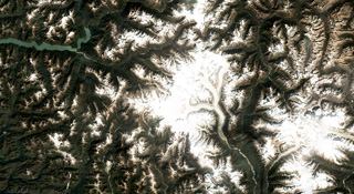 Silverthrone volcano in SW British Columbia, Canada, is below the glaciers in the center of this September 2018 Planet Labs satellite image monthly mosaic (N is at the top; this image is approximately 150 km across). It is a roughly 20-km-wide eroded caldera complex containing lava domes and flows.
Satellite image courtesy of Planet Labs Inc., 2018 (https://www.planet.com/).
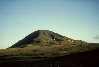
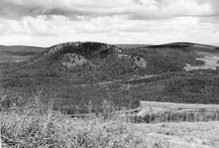 Nazko cone is the easternmost and youngest volcano of the Anahim volcanic belt in the Chilcotin-Nechako Plateau in central British Columbia. The 120-m-high cone is seen here across a valley from the SW. The central subglacial mound is partly enveloped by younger, coalescing cones that form the summit ridge. A 7,200-year-old lava flow forms the forested margin of the swamp in the middle foreground.
Photo by Geological Survey of Canada (courtesy of Cathie Hickson).
 Mount Garibaldi is to the left in the background. In the foreground are glacially eroded granitic rocks of the Coast Range Batholith that extend south to the Mount Seymour area in the foreground, immediately north of the city of Vancouver.
 Photo by Lee Siebert (Smithsonian Institution).
 Shallow ponds are seen across the surface of valley-filling lava flows of the Iskut-Unuk volcanic field. The flows traveled south 5 km where they crossed the border into Alaska and dammed the Blue River, forming several small lakes and traveling a total of approximately 22 km. The Iskut-Unuk River Cone Group consists of eight small basaltic centers at the southern end of the Stikine volcanic belt that range in age from about 70,000 to only a few hundred years old and form one of the youngest volcanic fields in Canada.
Photo by Ben Edwards, 1997 (Dickinson College, Pennsylvania).
 The Tseax River scoria cones (Aiyansh volcano) at the southern end of the Stikine volcanic belt have been the site of some of the youngest volcanic eruptions in Canada. This photo shows a tumulus in the middle of a broad lava plain in the Nass River valley produced by the Tseax River flow, which traveled 22.5 km. The volcanic field has erupted at least twice (625 and 220 radiocarbon years ago), and activity was recorded in tribal legends.
Photo by Ben Edwards (Dickinson College, Pennsylvania).
 The inconspicuous ice-and-debris covered vent of the Bridge River eruption, the last eruption of the Meager volcanic complex, is located near the center of the photo immediately above the forested valley fill. The Bridge River eruption, one of the largest-known Holocene explosive eruptions in Canada, deposited ash to the east across British Columbia into Alberta.
Photo by Willie Scott, 1990 (U.S. Geological Survey).
 Mount Edziza is an approximately 30-km-long volcanic range that forms the northernmost edifice of the Mount Edziza volcanic complex, and is shown in this July 2018 Planet Labs satellite image monthly mosaic (N is at the top; this image is approximately 42 km across). Many eruptions occurred within ice and water, such as the Tennena cone on the western flank about two-thirds down the ice cap in this view, forming pillow lavas and hydrovolcanic clastic deposits.
Satellite image courtesy of Planet Labs Inc., 2018 (https://www.planet.com/).
 Volcano Mountain is a cone within the Fort Selkirk volcanic field in the central Yukon Territory, near the junction of the Yukon and Pelly rivers, and is Canada's northernmost Holocene volcano. Volcano Mountain comprises a scoria cone and a series of lava flows that traveled to the NE and SW.
 Photo by Lionel Jackson (Geological Survey of Canada).
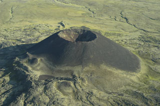 Scoria cones, such as Eve Cone on the flank of Edziza volcano, are formed by the explosive ejection of fragmental material that accumulated around the vent. This symmetrical cone is part of the Desolation Lava Field on the northern flank of Edziza and is one of the youngest features of the volcano. Basaltic lava flows erupted from the base of the cone, which reaches about 150 m high and has a 45-m-deep crater.
Photo by Ben Edwards, 1995 (Dickinson College, Pennsylvania).
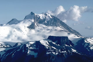
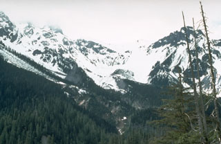
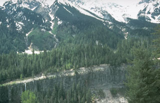
 The Mount Meager volcanic complex is the northernmost major volcanic center in the Canadian part of the Cascade Range. This Tertiary to Holocene complex has erupted mafic to felsic magmas from at least eight vents. The most recent eruption produced a pyroclastic flow and lava flow from a NE-flank vent about 2,350 years ago. This view from the Lillooet River valley to the west shows, from left to right, the glacially eroded volcanic necks of Mount Capricorn, Meager Mountain, and Plinth Mountain.
Photo by Willie Scott, 1990 (U.S. Geological Survey).
 The irregular mound in the center of the photo is Cinder Cone, a late-Pleistocene cone of the Garibaldi Lake volcanic field. The cone formed during two periods of activity, the latest of which produced a lava flow down the glaciated valley to the north.
Photo by Lee Siebert, 1983 (Smithsonian Institution).
 The Wells Gray-Clearwater volcanic field in the Quesnel Highland of east-central British Columbia contains basaltic cones and lava flows of early Pleistocene-to-Holocene age. Dragon Cone (above) produced lava flows that traveled 14 km down Falls Creek to the Clearwater River. Pleistocene deposits include plateau-capping lava flows, subglacial mounds and tuyas, and hyaloclastites. Several cones were active during the Holocene, and the latest eruption took place from Kostal cone about 400 years ago.
Photo by Cathie Hickson (Geological Survey of Canada).
 The Heart Peaks volcanic center in Canada is down the center of this September 2019 Planet Labs satellite image monthly mosaic (N is at the top; this image is approximately 58 km across). The volcano was constructed through lava flow emplacement, then lava dome growth to form the summit ridge.
Satellite image courtesy of Planet Labs Inc., 2019 (https://www.planet.com/).
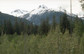
 Mount Capricorn, Meager Mountain, and Plinth Mountain (left to right) are seen above the Lillooet River valley to the SE. They are three of the eight volcanic centers forming the Tertiary to Holocene Meager volcanic complex. Deep glacial erosion has exposed the interior of a group of dissected rhyodacite volcanic remnants that form the highest peaks.
Photo by Lee Siebert, 1987 (Smithsonian Institution).
 The pyroclastic flow deposit forming the foreground canyon wall on the Lillooet River was erupted from the Bridge River vent on the NE flank of the Meager volcanic complex. A vent to the upper right, below the notch in the skyline, was the source of an explosive eruption about 2,350 years ago. It produced ash that dispersed east across British Columbia and Alberta, the pyroclastic flow mentioned here, and a 3-km-long rhyodacite lava flow.
Photo by Willie Scott, 1990 (U.S. Geological Survey).
 The Bridge River cones group is within the Garibaldi Volcanic Belt in SW Canada and is shown in the center of this September 2020 Planet Labs satellite image monthly mosaic (N is at the top; this image is approximately 22 km across). Younger lava flows that are potentially post-glaciation are present N of Bridge River.
Satellite image courtesy of Planet Labs Inc., 2020 (https://www.planet.com/).
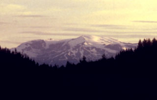
 Meszah Peak of the Level Mountain volcanic complex is viewed from the east. The dark unit in the center foreground is alkali basalt. Trachytic lava flows and agglomerates form a series of benches at the base of Meszah Peak. The cliffs are composed of welded tuffs capped by thin basaltic lava flows. Level Mountain volcano is the most voluminous and most persistent eruptive center of the Stikine volcanic belt in NW British Columbia, covering an area of 1,800 km2 north of Telegraph Creek.
Photo by Geological Survey of Canada (courtesy of Cathie Hickson).
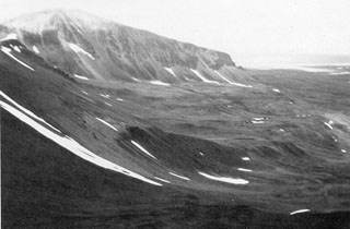
 Hoodoo Mountain, as seen from the SE across the Iskut River in northwestern British Columbia, is a flat-topped stratovolcano. It has an ice cap 3 km in diameter and has had several episodes of subglacial eruptions. Most of the deposits are lava flows. The oldest eruptions of the volcano occurred about 100,000 years ago and the most recent eruptions about 9,000 years ago. This is one of the largest peralkaline volcanoes in the northern Cordilleran volcanic province.
Photo by Ben Edwards, 1994 (Dickinson College, Pennsylvania).
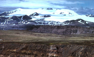 The central ice-covered summit complex of Mount Edziza is seen here from the SW rising above the Kitsu and Big Raven plateaus. Late-Tertiary lava flows are the foreground. The smaller hills at the base of the icecap are Quaternary cones. Mount Edziza contains a 2-km-wide, ice-filled caldera at its summit, and numerous ice-contact features and products of subglacial eruptions. The complex contains numerous Holocene cones, some of which are younger than about 1,300 years.
Photo by Jack Souther, 1992 (Geological Survey of Canada).
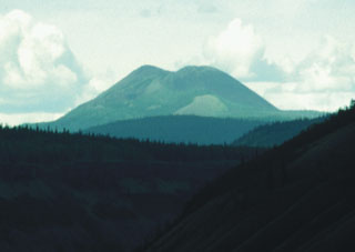
 The Mount Edziza complex, seen here from the east along the Cassiar-Stewart Highway, is part of a large volcanic plateau that is the centerpiece of Mount Edziza Provincial Park, one of the largest in British Columbia. The complex was constructed over the past 7.5 million years during five cycles beginning with eruption of alkali basalts and ending with felsic and basaltic eruptions as late about 1,000 years ago. Numerous ice-contact features and products of subglacial eruptions are found in the Mount Edziza complex.
Photo by Ben Edwards, 1995 (Dickinson College, Pennsylvania).
This is a compilation of Canada volcano information sources, such as official monitoring or other government agencies.
| Volcano Observatories |
|---|
| Natural Resources Canada (NRCAN) |
| Volcanic Ash Advisory Center |
|---|
| Montreal Volcanic Ash Advisory Centre (VAAC) |
| - Montreal VAAC Notices |