
The Global Volcanism Program has no activity reports available for Sand Mountain Field.
The Global Volcanism Program has no Weekly Reports available for Sand Mountain Field.
The Global Volcanism Program has no Bulletin Reports available for Sand Mountain Field.
|
|
||||||||||||||||||||||||||
There is data available for 2 confirmed Holocene eruptive periods.
0950 BCE ± 200 years Confirmed Eruption (Explosive / Effusive) VEI: 4
| Episode 1 | Eruption (Explosive / Effusive) | |||||||||||||||||||||||||||||||||||||||||||||
|---|---|---|---|---|---|---|---|---|---|---|---|---|---|---|---|---|---|---|---|---|---|---|---|---|---|---|---|---|---|---|---|---|---|---|---|---|---|---|---|---|---|---|---|---|---|
| 0950 BCE ± 200 years - Unknown | Evidence from Correlation: Magnetism | ||||||||||||||||||||||||||||||||||||||||||||
|
List of 7 Events for Episode 1
|
|||||||||||||||||||||||||||||||||||||||||||||
5050 BCE (?) Confirmed Eruption (Explosive / Effusive) VEI: 2 (?)
| Episode 1 | Eruption (Explosive / Effusive) | Jack Mountain | |||||||||||||||||||||||||||||||||||||||
|---|---|---|---|---|---|---|---|---|---|---|---|---|---|---|---|---|---|---|---|---|---|---|---|---|---|---|---|---|---|---|---|---|---|---|---|---|---|---|---|---|
| 5050 BCE (?) - Unknown | Evidence from Correlation: Magnetism | |||||||||||||||||||||||||||||||||||||||
|
List of 6 Events for Episode 1 at Jack Mountain
|
||||||||||||||||||||||||||||||||||||||||
This compilation of synonyms and subsidiary features may not be comprehensive. Features are organized into four major categories: Cones, Craters, Domes, and Thermal Features. Synonyms of features appear indented below the primary name. In some cases additional feature type, elevation, or location details are provided.
Cones |
||||
| Feature Name | Feature Type | Elevation | Latitude | Longitude |
| Central Group | Pyroclastic cone | 44° 24' 0.00" N | 121° 56' 0.00" W | |
| Little Nash Crater | Pyroclastic cone | 1255 m | 44° 26' 0.00" N | 121° 57' 0.00" W |
| Lost Lake Group | Pyroclastic cone | 1458 m | 44° 26' 0.00" N | 121° 56' 0.00" W |
| Nash Crater | Pyroclastic cone | 1462 m | 44° 25' 0.00" N | 121° 57' 0.00" W |
| Sand Mountain Cones | Pyroclastic cone | 1664 m | 44° 23' 0.00" N | 121° 56' 0.00" W |
| South Group | Pyroclastic cone | 44° 21' 0.00" N | 121° 56' 0.00" W | |
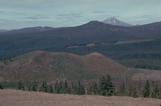 The Sand Mountain volcanic field contains a group of 23 scoria cones that erupted along a N-S line NW of Mount Washington. Two cone alignments diverge at the highest cone, Sand Mountain. This view looks along the NNE alignment with Mount Jefferson visible in the distance. The Sand Mountain cones and associated lava flows erupted between about 3,000 and 4,000 years ago.
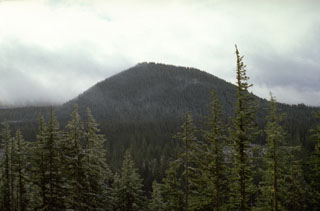 Nash Crater scoria cone, seen here from Little Nash Crater to the NW, is part of a line of cones that diverges to the NNW from Sand Mountain. Lava flows from Nash Crater were emplaced about 3,850 years ago and traveled to the west where they blocked a stream drainage, forming Fish Lake.
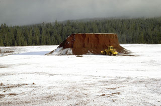 The flat summit of Little Nash Crater, a scoria cone of the Sand Mountain volcanic field in the central Oregon Cascades, has been extensively quarried to provide aggregate for highway construction. Red oxidized scoria from Little Nash Crater can be seen in road surfaces in the Santiam Pass area.
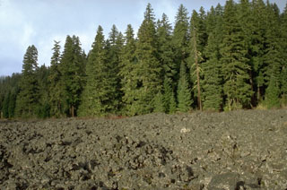 A lava flow, still largely unvegetated, was emplaced about 3,850 years ago from Nash Crater in the Sand Mountain volcanic field of the central Oregon Cascades. This and contemporaneous lava flows blocked local drainages, forming Lava Lake and Fish Lake.
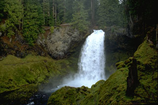 Sahalie Falls formed when lava flows erupted about 3,000 years ago from the Sand Mountain volcanic field traveled to the west, blocking the channel of the ancestral McKenzie River.
 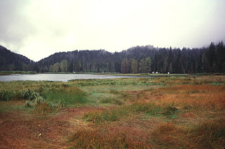 The Lost Lake scoria cones, seen here from the east across Lost Lake near Santiam Pass, are the youngest known volcanic products of the Sand Mountain volcanic field. The cones formed about 1,950 radiocarbon years ago during eruptions along a N-S-trending fissure at the northern end of the Sand Mountain group. Growth of the cones blocked Lost Creek, forming Lost Lake.
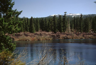 The snow-capped Sand Mountain scoria cones on the horizon were the source of the barren lava flow forming the far shore of Clear Lake. The lake formed when a series of lava flows erupted from the Sand Mountain volcanic field and traveled to the west, blocking the drainage of the ancestral McKenzie River. Standing stumps of the forest drowned by the rising lake waters have been radiocarbon dated to about 3,000 years ago and are still visible today.
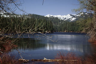 Fish Lake is an ephemeral lake on the western side of the Cascade Range crest that fills with water (seen here after spring snow-melt) but dries up during the summer. The lake formed when the Fish Lake lava flow from Nash Crater of the Sand Mountain volcanic field dammed local drainages. This flow and the Lava Lake flow from scoria cones at the northern half of the chain were both extruded about 3,850 radiocarbon years ago.
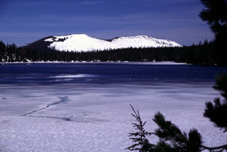 The Sand Mountain scoria cones rise to the WNW in late Spring across the partially frozen surface of Big Lake. South (left) and North Sand Mountain cones are the largest of a group of 23 scoria cones along a N-S line immediately west of the Cascade crest, NW of Mount Washington. A series of young, sparsely vegetated lava flows reaching the McKenzie River valley originated from vents to the west side and erupted primarily during about 3,000-4,000 years ago.
There are no samples for Sand Mountain Field in the Smithsonian's NMNH Department of Mineral Sciences Rock and Ore collection.
| Copernicus Browser | The Copernicus Browser replaced the Sentinel Hub Playground browser in 2023, to provide access to Earth observation archives from the Copernicus Data Space Ecosystem, the main distribution platform for data from the EU Copernicus missions. |
| MIROVA | Middle InfraRed Observation of Volcanic Activity (MIROVA) is a near real time volcanic hot-spot detection system based on the analysis of MODIS (Moderate Resolution Imaging Spectroradiometer) data. In particular, MIROVA uses the Middle InfraRed Radiation (MIR), measured over target volcanoes, in order to detect, locate and measure the heat radiation sourced from volcanic activity. |
| MODVOLC Thermal Alerts | Using infrared satellite Moderate Resolution Imaging Spectroradiometer (MODIS) data, scientists at the Hawai'i Institute of Geophysics and Planetology, University of Hawai'i, developed an automated system called MODVOLC to map thermal hot-spots in near real time. For each MODIS image, the algorithm automatically scans each 1 km pixel within it to check for high-temperature hot-spots. When one is found the date, time, location, and intensity are recorded. MODIS looks at every square km of the Earth every 48 hours, once during the day and once during the night, and the presence of two MODIS sensors in space allows at least four hot-spot observations every two days. Each day updated global maps are compiled to display the locations of all hot spots detected in the previous 24 hours. There is a drop-down list with volcano names which allow users to 'zoom-in' and examine the distribution of hot-spots at a variety of spatial scales. |
|
WOVOdat
Single Volcano View Temporal Evolution of Unrest Side by Side Volcanoes |
WOVOdat is a database of volcanic unrest; instrumentally and visually recorded changes in seismicity, ground deformation, gas emission, and other parameters from their normal baselines. It is sponsored by the World Organization of Volcano Observatories (WOVO) and presently hosted at the Earth Observatory of Singapore.
GVMID Data on Volcano Monitoring Infrastructure The Global Volcano Monitoring Infrastructure Database GVMID, is aimed at documenting and improving capabilities of volcano monitoring from the ground and space. GVMID should provide a snapshot and baseline view of the techniques and instrumentation that are in place at various volcanoes, which can be use by volcano observatories as reference to setup new monitoring system or improving networks at a specific volcano. These data will allow identification of what monitoring gaps exist, which can be then targeted by remote sensing infrastructure and future instrument deployments. |
| Volcanic Hazard Maps | The IAVCEI Commission on Volcanic Hazards and Risk has a Volcanic Hazard Maps database designed to serve as a resource for hazard mappers (or other interested parties) to explore how common issues in hazard map development have been addressed at different volcanoes, in different countries, for different hazards, and for different intended audiences. In addition to the comprehensive, searchable Volcanic Hazard Maps Database, this website contains information about diversity of volcanic hazard maps, illustrated using examples from the database. This site is for educational purposes related to volcanic hazard maps. Hazard maps found on this website should not be used for emergency purposes. For the most recent, official hazard map for a particular volcano, please seek out the proper institutional authorities on the matter. |
| IRIS seismic stations/networks | Incorporated Research Institutions for Seismology (IRIS) Data Services map showing the location of seismic stations from all available networks (permanent or temporary) within a radius of 0.18° (about 20 km at mid-latitudes) from the given location of Sand Mountain Field. Users can customize a variety of filters and options in the left panel. Note that if there are no stations are known the map will default to show the entire world with a "No data matched request" error notice. |
| UNAVCO GPS/GNSS stations | Geodetic Data Services map from UNAVCO showing the location of GPS/GNSS stations from all available networks (permanent or temporary) within a radius of 20 km from the given location of Sand Mountain Field. Users can customize the data search based on station or network names, location, and time window. Requires Adobe Flash Player. |
| DECADE Data | The DECADE portal, still in the developmental stage, serves as an example of the proposed interoperability between The Smithsonian Institution's Global Volcanism Program, the Mapping Gas Emissions (MaGa) Database, and the EarthChem Geochemical Portal. The Deep Earth Carbon Degassing (DECADE) initiative seeks to use new and established technologies to determine accurate global fluxes of volcanic CO2 to the atmosphere, but installing CO2 monitoring networks on 20 of the world's 150 most actively degassing volcanoes. The group uses related laboratory-based studies (direct gas sampling and analysis, melt inclusions) to provide new data for direct degassing of deep earth carbon to the atmosphere. |
| Large Eruptions of Sand Mountain Field | Information about large Quaternary eruptions (VEI >= 4) is cataloged in the Large Magnitude Explosive Volcanic Eruptions (LaMEVE) database of the Volcano Global Risk Identification and Analysis Project (VOGRIPA). |
| EarthChem | EarthChem develops and maintains databases, software, and services that support the preservation, discovery, access and analysis of geochemical data, and facilitate their integration with the broad array of other available earth science parameters. EarthChem is operated by a joint team of disciplinary scientists, data scientists, data managers and information technology developers who are part of the NSF-funded data facility Integrated Earth Data Applications (IEDA). IEDA is a collaborative effort of EarthChem and the Marine Geoscience Data System (MGDS). |

