
T-wave swarm devoid of tremor during 6-27 September 2001
At approximately 2030 on 6 September 2001 a large seismic swarm was detected at the N end of the Juan de Fuca Ridge (figure 1). Just N of this point the ridge becomes truncated by the Sovanco Fracture Zone. The seismicity had some of the primary characteristics of magmatic activity, including vigorous swarms of small earthquakes, but did not include any detectable continuous tremor. After the initial event, activity increased and epicenters propagated southward to within 5 km of known hydrothermal vents and drill holes (figure 2). By 27 September, after nearly 14,000 detected earthquakes, seismic activity had slowed to near-background levels (figure 3). During 4-7 October, the Canadian RV Tully visited the site for water column sampling.
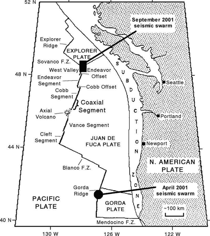 |
Figure 1. General plate-tectonic map of the NE Pacific Ocean showing the North American, Pacific, Explorer, Juan de Fuca, and Gorda plates. The Juan de Fuca Ridge extends from West Valley to Cleft Segment, along the W margin of the Juan de Fuca plate. The seismic swarm discussed in this report lies within the darkened rectangle. The darkened circle shows the approximate location of the April 2001 Gorda Ridge seismic swarm. Courtesy of Bill Chadwick and NOAA. |
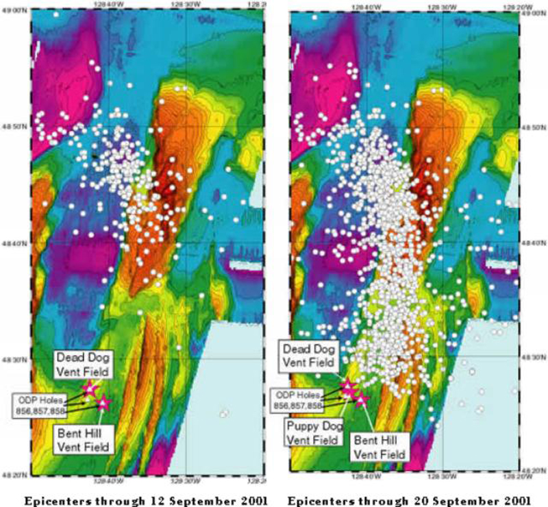 |
Figure 2. Epicenter maps illustrating the September 2001 West Valley Segment seismic swarm. Between 12 and 20 September epicenters had clearly migrated south. Coordinates on the map boundaries indicate that by 20 September the swarm's N-S swath extended approximately 30 km. Courtesy of the Vent Acoustics Program. |
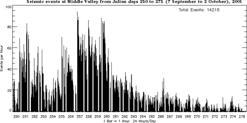 |
Figure 3. Histogram of seismic events along the West Valley Segment of the Juan de Fuca Ridge during 7 September through 2 October 2001. Courtesy of the PMEL Vent Acoustics Program. |
The land seismic network operated by the Pacific Geoscience Center of the Geological Survey of Canada recorded and produced moment tensor solutions for several of the larger events, indicating a mixture of normal and strike-slip motion. Strike-slip events are oriented parallel to Juan de Fuca orientation (15°) and are likely associated with the ridge system. The complex interplay between the Nootka fault and the Juan de Fuca volcanic system results in a diffuse triple junction with correspondingly complex stress fields. Further detailed examination of the joint data sets will be required to unravel the total picture. A description of the site can be found in Davis and Villinger (1992).
The general location of the swarm (48.78°N, 128.64°W) was on the eastern edge of a large sedimented feature called Middle Valley. The Juan de Fuca Ridge is located just N of the Gorda Ridge, along the boundary between the Juan de Fuca and Pacific plates. A seismic swarm along the Jackson Segment of the Gorda Ridge (figure 8) occurred in early April 2001 (BGVN 26:08). The seismic activity was detected by NOAA's Pacific Marine Environmental Laboratory (PMEL) T-phase Monitoring System. They access the U.S. Navy's SOund SUrveillance System (SOSUS) to monitor ocean acoustics.
Reference. Davis, E.E., and Villinger, H., 1992, Proceedings of the Ocean Drilling Program, Initial Reports, v. 139, p. 9-41.
Information Contacts: Chris Fox and Robert Dziak, Vents Acoustics Program, NOAA Pacific Marine Environmental Laboratory (PMEL), 2115 SE Osu Drive, Newport, OR 97365 USA (URL: https://www.pmel.noaa.gov/eoi/); Garry Rogers, Geological Survey of Canada, GSC Pacific - Sidney Subdivision, Pacific Geoscience Centre, P.O. Box 6000, 9860 West Saanich Road, Sidney, BC V8L 4B2, Canada (URL: http://www.earthquakescanada.nrcan.gc.ca/); InterRidge Office, Ocean Research Institute, University of Tokyo, 1-15-1 Minamidai, Nakano-ku, Tokyo 164-8639, Japan (URL: http://www.interridge.org/).
The Global Volcanism Program has no Weekly Reports available for West Valley Segment.
Reports are organized chronologically and indexed below by Month/Year (Publication Volume:Number), and include a one-line summary. Click on the index link or scroll down to read the reports.
T-wave swarm devoid of tremor during 6-27 September 2001
At approximately 2030 on 6 September 2001 a large seismic swarm was detected at the N end of the Juan de Fuca Ridge (figure 1). Just N of this point the ridge becomes truncated by the Sovanco Fracture Zone. The seismicity had some of the primary characteristics of magmatic activity, including vigorous swarms of small earthquakes, but did not include any detectable continuous tremor. After the initial event, activity increased and epicenters propagated southward to within 5 km of known hydrothermal vents and drill holes (figure 2). By 27 September, after nearly 14,000 detected earthquakes, seismic activity had slowed to near-background levels (figure 3). During 4-7 October, the Canadian RV Tully visited the site for water column sampling.
|
Figure 1. General plate-tectonic map of the NE Pacific Ocean showing the North American, Pacific, Explorer, Juan de Fuca, and Gorda plates. The Juan de Fuca Ridge extends from West Valley to Cleft Segment, along the W margin of the Juan de Fuca plate. The seismic swarm discussed in this report lies within the darkened rectangle. The darkened circle shows the approximate location of the April 2001 Gorda Ridge seismic swarm. Courtesy of Bill Chadwick and NOAA. |
|
Figure 2. Epicenter maps illustrating the September 2001 West Valley Segment seismic swarm. Between 12 and 20 September epicenters had clearly migrated south. Coordinates on the map boundaries indicate that by 20 September the swarm's N-S swath extended approximately 30 km. Courtesy of the Vent Acoustics Program. |
|
Figure 3. Histogram of seismic events along the West Valley Segment of the Juan de Fuca Ridge during 7 September through 2 October 2001. Courtesy of the PMEL Vent Acoustics Program. |
The land seismic network operated by the Pacific Geoscience Center of the Geological Survey of Canada recorded and produced moment tensor solutions for several of the larger events, indicating a mixture of normal and strike-slip motion. Strike-slip events are oriented parallel to Juan de Fuca orientation (15°) and are likely associated with the ridge system. The complex interplay between the Nootka fault and the Juan de Fuca volcanic system results in a diffuse triple junction with correspondingly complex stress fields. Further detailed examination of the joint data sets will be required to unravel the total picture. A description of the site can be found in Davis and Villinger (1992).
The general location of the swarm (48.78°N, 128.64°W) was on the eastern edge of a large sedimented feature called Middle Valley. The Juan de Fuca Ridge is located just N of the Gorda Ridge, along the boundary between the Juan de Fuca and Pacific plates. A seismic swarm along the Jackson Segment of the Gorda Ridge (figure 8) occurred in early April 2001 (BGVN 26:08). The seismic activity was detected by NOAA's Pacific Marine Environmental Laboratory (PMEL) T-phase Monitoring System. They access the U.S. Navy's SOund SUrveillance System (SOSUS) to monitor ocean acoustics.
Reference. Davis, E.E., and Villinger, H., 1992, Proceedings of the Ocean Drilling Program, Initial Reports, v. 139, p. 9-41.
Information Contacts: Chris Fox and Robert Dziak, Vents Acoustics Program, NOAA Pacific Marine Environmental Laboratory (PMEL), 2115 SE Osu Drive, Newport, OR 97365 USA (URL: https://www.pmel.noaa.gov/eoi/); Garry Rogers, Geological Survey of Canada, GSC Pacific - Sidney Subdivision, Pacific Geoscience Centre, P.O. Box 6000, 9860 West Saanich Road, Sidney, BC V8L 4B2, Canada (URL: http://www.earthquakescanada.nrcan.gc.ca/); InterRidge Office, Ocean Research Institute, University of Tokyo, 1-15-1 Minamidai, Nakano-ku, Tokyo 164-8639, Japan (URL: http://www.interridge.org/).
|
|
||||||||||||||||||
The Global Volcanism Program is not aware of any Holocene eruptions from West Valley Segment. If this volcano has had large eruptions (VEI >= 4) prior to 12,000 years ago, information might be found on the West Valley Segment page in the LaMEVE (Large Magnitude Explosive Volcanic Eruptions) database, a part of the Volcano Global Risk Identification and Analysis Project (VOGRIPA).
The Global Volcanism Program has no synonyms or subfeatures listed for West Valley Segment.
The Global Volcanism Program has no photographs available for West Valley Segment.
There are no samples for West Valley Segment in the Smithsonian's NMNH Department of Mineral Sciences Rock and Ore collection.
| Copernicus Browser | The Copernicus Browser replaced the Sentinel Hub Playground browser in 2023, to provide access to Earth observation archives from the Copernicus Data Space Ecosystem, the main distribution platform for data from the EU Copernicus missions. |
| MIROVA | Middle InfraRed Observation of Volcanic Activity (MIROVA) is a near real time volcanic hot-spot detection system based on the analysis of MODIS (Moderate Resolution Imaging Spectroradiometer) data. In particular, MIROVA uses the Middle InfraRed Radiation (MIR), measured over target volcanoes, in order to detect, locate and measure the heat radiation sourced from volcanic activity. |
| MODVOLC Thermal Alerts | Using infrared satellite Moderate Resolution Imaging Spectroradiometer (MODIS) data, scientists at the Hawai'i Institute of Geophysics and Planetology, University of Hawai'i, developed an automated system called MODVOLC to map thermal hot-spots in near real time. For each MODIS image, the algorithm automatically scans each 1 km pixel within it to check for high-temperature hot-spots. When one is found the date, time, location, and intensity are recorded. MODIS looks at every square km of the Earth every 48 hours, once during the day and once during the night, and the presence of two MODIS sensors in space allows at least four hot-spot observations every two days. Each day updated global maps are compiled to display the locations of all hot spots detected in the previous 24 hours. There is a drop-down list with volcano names which allow users to 'zoom-in' and examine the distribution of hot-spots at a variety of spatial scales. |
|
WOVOdat
Single Volcano View Temporal Evolution of Unrest Side by Side Volcanoes |
WOVOdat is a database of volcanic unrest; instrumentally and visually recorded changes in seismicity, ground deformation, gas emission, and other parameters from their normal baselines. It is sponsored by the World Organization of Volcano Observatories (WOVO) and presently hosted at the Earth Observatory of Singapore.
GVMID Data on Volcano Monitoring Infrastructure The Global Volcano Monitoring Infrastructure Database GVMID, is aimed at documenting and improving capabilities of volcano monitoring from the ground and space. GVMID should provide a snapshot and baseline view of the techniques and instrumentation that are in place at various volcanoes, which can be use by volcano observatories as reference to setup new monitoring system or improving networks at a specific volcano. These data will allow identification of what monitoring gaps exist, which can be then targeted by remote sensing infrastructure and future instrument deployments. |
| Volcanic Hazard Maps | The IAVCEI Commission on Volcanic Hazards and Risk has a Volcanic Hazard Maps database designed to serve as a resource for hazard mappers (or other interested parties) to explore how common issues in hazard map development have been addressed at different volcanoes, in different countries, for different hazards, and for different intended audiences. In addition to the comprehensive, searchable Volcanic Hazard Maps Database, this website contains information about diversity of volcanic hazard maps, illustrated using examples from the database. This site is for educational purposes related to volcanic hazard maps. Hazard maps found on this website should not be used for emergency purposes. For the most recent, official hazard map for a particular volcano, please seek out the proper institutional authorities on the matter. |
| IRIS seismic stations/networks | Incorporated Research Institutions for Seismology (IRIS) Data Services map showing the location of seismic stations from all available networks (permanent or temporary) within a radius of 0.18° (about 20 km at mid-latitudes) from the given location of West Valley Segment. Users can customize a variety of filters and options in the left panel. Note that if there are no stations are known the map will default to show the entire world with a "No data matched request" error notice. |
| UNAVCO GPS/GNSS stations | Geodetic Data Services map from UNAVCO showing the location of GPS/GNSS stations from all available networks (permanent or temporary) within a radius of 20 km from the given location of West Valley Segment. Users can customize the data search based on station or network names, location, and time window. Requires Adobe Flash Player. |
| DECADE Data | The DECADE portal, still in the developmental stage, serves as an example of the proposed interoperability between The Smithsonian Institution's Global Volcanism Program, the Mapping Gas Emissions (MaGa) Database, and the EarthChem Geochemical Portal. The Deep Earth Carbon Degassing (DECADE) initiative seeks to use new and established technologies to determine accurate global fluxes of volcanic CO2 to the atmosphere, but installing CO2 monitoring networks on 20 of the world's 150 most actively degassing volcanoes. The group uses related laboratory-based studies (direct gas sampling and analysis, melt inclusions) to provide new data for direct degassing of deep earth carbon to the atmosphere. |
| EarthChem | EarthChem develops and maintains databases, software, and services that support the preservation, discovery, access and analysis of geochemical data, and facilitate their integration with the broad array of other available earth science parameters. EarthChem is operated by a joint team of disciplinary scientists, data scientists, data managers and information technology developers who are part of the NSF-funded data facility Integrated Earth Data Applications (IEDA). IEDA is a collaborative effort of EarthChem and the Marine Geoscience Data System (MGDS). |

