The Global Volcanism Program has no activity reports available for Isla San Luis.
The Global Volcanism Program has no Weekly Reports available for Isla San Luis.
The Global Volcanism Program has no Bulletin Reports available for Isla San Luis.
|
|
||||||||||||||||||||||||||||
There is data available for 3 confirmed eruptive periods.
1141 BCE ± 203 years Confirmed Eruption (Explosive / Effusive)
| Episode 1 | Eruption (Explosive / Effusive) | Central rhyolite domes | |||||||||||||
|---|---|---|---|---|---|---|---|---|---|---|---|---|---|---|
| 1141 BCE ± 203 years - Unknown | Evidence from Isotopic: 14C (uncalibrated) | |||||||||||||
| Seven marine mollusk shells were analyzed by Hausback et al. (2003) using 14C acceleration methods to date beach deposits at three stratigraphic levels interbedded with volcanic layers. Three shells were dated in beach sands directly below the youngest of the pyroclastic deposits on the island: coarse, rhyolitic breadcrust-bomb-containing tephras associated with the early eruptive stages of the growth of the central rhyolite domes; these yield a maximum age of 2,888 to 3,289 BP for the latest rhyolite eruptions. Hausback et al. (2003) also attempted to use obsidian hydration analysis to date this material, measuring hydration rinds of 3.6 and 3.7 microns thickness two separate bombs (averages of 5 measurements each); the hydration rate for this obsidian has not been established, but a typical hydration rate (82.74 microns ^2.06) yields an age of 1,225 years for this tephra (725 CE). | ||||||||||||||
|
List of 1 Events for Episode 1 at Central rhyolite domes
|
||||||||||||||
1212 BCE ± 127 years Confirmed Eruption (Explosive / Effusive)
| Episode 1 | Eruption (Explosive / Effusive) | NW beach cliffs | |||||||||||||
|---|---|---|---|---|---|---|---|---|---|---|---|---|---|---|
| 1212 BCE ± 127 years - Unknown | Evidence from Isotopic: 14C (uncalibrated) | |||||||||||||
| Seven marine mollusk shells were analyzed by Hausback et al. (2003) using 14C acceleration methods to date beach deposits at three stratigraphic levels interbedded with volcanic layers. Three mollusks were dated in beach deposits below the intermediate lavas exposed along the NW beach cliffs; these give a maximum age of 3,036 to 3,289 BP. | ||||||||||||||
|
List of 1 Events for Episode 1 at NW beach cliffs
|
||||||||||||||
2647 BCE ± 128 years Confirmed Eruption (Explosive / Effusive)
| Episode 1 | Eruption (Explosive / Effusive) | ||||||||||||||
|---|---|---|---|---|---|---|---|---|---|---|---|---|---|---|
| 2647 BCE ± 128 years - Unknown | Evidence from Isotopic: 14C (uncalibrated) | |||||||||||||
| Seven marine mollusk shells were analyzed by Hausback et al. (2003) using 14C acceleration methods to date beach deposits at three stratigraphic levels interbedded with volcanic layers. One shell was dated at 4,469-4,725 BP from the oldest palagonitic pyroclastic deposits exposed near sea level. | ||||||||||||||
|
List of 1 Events for Episode 1
|
||||||||||||||
This compilation of synonyms and subsidiary features may not be comprehensive. Features are organized into four major categories: Cones, Craters, Domes, and Thermal Features. Synonyms of features appear indented below the primary name. In some cases additional feature type, elevation, or location details are provided.
Synonyms |
||||
| Encantada Mayor, La | Salvatierra | ||||
Cones |
||||
| Feature Name | Feature Type | Elevation | Latitude | Longitude |
| Plaza de Toros | Tuff ring | 50 m | 29° 58' 0.00" N | 114° 24' 0.00" W |
| Poma, Isla | Tuff ring | 29° 59' 0.00" N | 114° 23' 0.00" W | |
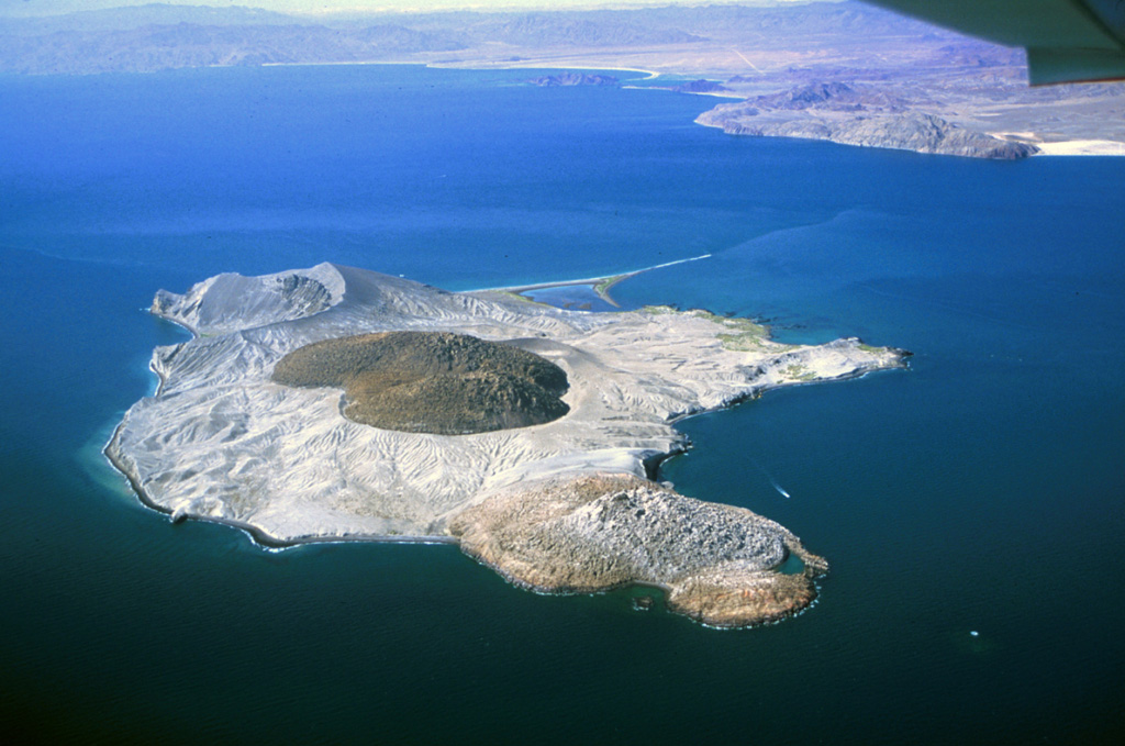
 Isla San Luis, seen here from the SW with a large rhyolitic lava dome near the center, is the largest of the seven Encantada islands in the northern part of the Gulf of California. The roughly 180-m-high island lies 3 km off the eastern shore of Baja California. An older lava dome forms the NE tip of the island, and an eroded tuff ring lies at the SE tip. The lava dome seen here in the center of the island was constructed within a tuff ring and is the youngest volcanic feature.
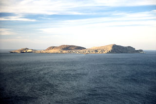
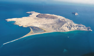 Isla San Luis is seen here from the south with a 2-km-long spit (at low tide) to the lower left. The main features of the island are a rhyolite lava dome forming the NW tip of the island, the darker rhyolitic obsidian dome and coulee in the center, and an eroded tuff ring at the SE tip of the island (to the right). Another tuff ring, Isla Poma, lies 1 km NE of Isla San Luis and is visible to the right.
 Isla San Luis lies across a narrow channel from the NE coast of Baja California (in the background). A rhyolite obsidian dome is in the center of the small island. An older dome forms the northern part of the island (foreground) and is partially mantled by ash and pumice from the central dome. An eroded tuff ring, Plaza de Toros, occupies the SE end of the island.
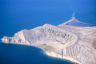 The Plaza de Toros tuff ring on the SE side of Isla San Luis is seen here from the east in 2000. Remnants of dacite lava flows are visible in the upper walls of the crater. Only a third of the tuff ring is still standing; the rest has subsided along normal faults or was eroded by wave action. Longshore currents have redistributed volcanic deposits to produce the tombolo to the upper right that forms the SW tip of the island and is 2 km long at low tide.
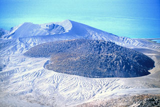 An obsidian lava dome fills the crater in the center of Isla San Luis, off the NE coast of Baja California, seen in this photo that was taken in 2000. As growth of the dome continued, a thick coulee advanced to the south and overflowed the rim to form the broad lobe behind it. The eroded Plaza de Toros tuff ring in the left background forms the SE tip of the island.
There are no samples for Isla San Luis in the Smithsonian's NMNH Department of Mineral Sciences Rock and Ore collection.
| Copernicus Browser | The Copernicus Browser replaced the Sentinel Hub Playground browser in 2023, to provide access to Earth observation archives from the Copernicus Data Space Ecosystem, the main distribution platform for data from the EU Copernicus missions. |
| MIROVA | Middle InfraRed Observation of Volcanic Activity (MIROVA) is a near real time volcanic hot-spot detection system based on the analysis of MODIS (Moderate Resolution Imaging Spectroradiometer) data. In particular, MIROVA uses the Middle InfraRed Radiation (MIR), measured over target volcanoes, in order to detect, locate and measure the heat radiation sourced from volcanic activity. |
| MODVOLC Thermal Alerts | Using infrared satellite Moderate Resolution Imaging Spectroradiometer (MODIS) data, scientists at the Hawai'i Institute of Geophysics and Planetology, University of Hawai'i, developed an automated system called MODVOLC to map thermal hot-spots in near real time. For each MODIS image, the algorithm automatically scans each 1 km pixel within it to check for high-temperature hot-spots. When one is found the date, time, location, and intensity are recorded. MODIS looks at every square km of the Earth every 48 hours, once during the day and once during the night, and the presence of two MODIS sensors in space allows at least four hot-spot observations every two days. Each day updated global maps are compiled to display the locations of all hot spots detected in the previous 24 hours. There is a drop-down list with volcano names which allow users to 'zoom-in' and examine the distribution of hot-spots at a variety of spatial scales. |
|
WOVOdat
Single Volcano View Temporal Evolution of Unrest Side by Side Volcanoes |
WOVOdat is a database of volcanic unrest; instrumentally and visually recorded changes in seismicity, ground deformation, gas emission, and other parameters from their normal baselines. It is sponsored by the World Organization of Volcano Observatories (WOVO) and presently hosted at the Earth Observatory of Singapore.
GVMID Data on Volcano Monitoring Infrastructure The Global Volcano Monitoring Infrastructure Database GVMID, is aimed at documenting and improving capabilities of volcano monitoring from the ground and space. GVMID should provide a snapshot and baseline view of the techniques and instrumentation that are in place at various volcanoes, which can be use by volcano observatories as reference to setup new monitoring system or improving networks at a specific volcano. These data will allow identification of what monitoring gaps exist, which can be then targeted by remote sensing infrastructure and future instrument deployments. |
| Volcanic Hazard Maps | The IAVCEI Commission on Volcanic Hazards and Risk has a Volcanic Hazard Maps database designed to serve as a resource for hazard mappers (or other interested parties) to explore how common issues in hazard map development have been addressed at different volcanoes, in different countries, for different hazards, and for different intended audiences. In addition to the comprehensive, searchable Volcanic Hazard Maps Database, this website contains information about diversity of volcanic hazard maps, illustrated using examples from the database. This site is for educational purposes related to volcanic hazard maps. Hazard maps found on this website should not be used for emergency purposes. For the most recent, official hazard map for a particular volcano, please seek out the proper institutional authorities on the matter. |
| IRIS seismic stations/networks | Incorporated Research Institutions for Seismology (IRIS) Data Services map showing the location of seismic stations from all available networks (permanent or temporary) within a radius of 0.18° (about 20 km at mid-latitudes) from the given location of Isla San Luis. Users can customize a variety of filters and options in the left panel. Note that if there are no stations are known the map will default to show the entire world with a "No data matched request" error notice. |
| UNAVCO GPS/GNSS stations | Geodetic Data Services map from UNAVCO showing the location of GPS/GNSS stations from all available networks (permanent or temporary) within a radius of 20 km from the given location of Isla San Luis. Users can customize the data search based on station or network names, location, and time window. Requires Adobe Flash Player. |
| DECADE Data | The DECADE portal, still in the developmental stage, serves as an example of the proposed interoperability between The Smithsonian Institution's Global Volcanism Program, the Mapping Gas Emissions (MaGa) Database, and the EarthChem Geochemical Portal. The Deep Earth Carbon Degassing (DECADE) initiative seeks to use new and established technologies to determine accurate global fluxes of volcanic CO2 to the atmosphere, but installing CO2 monitoring networks on 20 of the world's 150 most actively degassing volcanoes. The group uses related laboratory-based studies (direct gas sampling and analysis, melt inclusions) to provide new data for direct degassing of deep earth carbon to the atmosphere. |
| Large Eruptions of Isla San Luis | Information about large Quaternary eruptions (VEI >= 4) is cataloged in the Large Magnitude Explosive Volcanic Eruptions (LaMEVE) database of the Volcano Global Risk Identification and Analysis Project (VOGRIPA). |
| EarthChem | EarthChem develops and maintains databases, software, and services that support the preservation, discovery, access and analysis of geochemical data, and facilitate their integration with the broad array of other available earth science parameters. EarthChem is operated by a joint team of disciplinary scientists, data scientists, data managers and information technology developers who are part of the NSF-funded data facility Integrated Earth Data Applications (IEDA). IEDA is a collaborative effort of EarthChem and the Marine Geoscience Data System (MGDS). |

