
The Global Volcanism Program has no activity reports available for Papayo.
The Global Volcanism Program has no Weekly Reports available for Papayo.
The Global Volcanism Program has no Bulletin Reports available for Papayo.
|
|
||||||||||||||||||||||||||
The Global Volcanism Program is not aware of any Holocene eruptions from Papayo. If this volcano has had large eruptions (VEI >= 4) prior to 12,000 years ago, information might be found on the Papayo page in the LaMEVE (Large Magnitude Explosive Volcanic Eruptions) database, a part of the Volcano Global Risk Identification and Analysis Project (VOGRIPA).
This compilation of synonyms and subsidiary features may not be comprehensive. Features are organized into four major categories: Cones, Craters, Domes, and Thermal Features. Synonyms of features appear indented below the primary name. In some cases additional feature type, elevation, or location details are provided.
Cones |
||||
| Feature Name | Feature Type | Elevation | Latitude | Longitude |
| Iztaltetlac, Cerro | Pyroclastic cone | 3200 m | 19° 18' 0.00" N | 98° 44' 0.00" W |
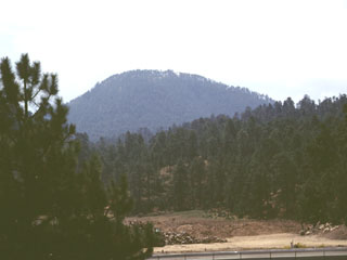 The Cerro Papayo dacite lava dome is located 2.5 km S of the pass in the northern Sierra Nevada between Mexico City and Puebla. The 1-km-wide dome rises 230 m above surrounding lava flows and produced voluminous lava flows that traveled about 10 km ENE toward the Puebla basin and 10 km WSW into the Valley of Mexico.
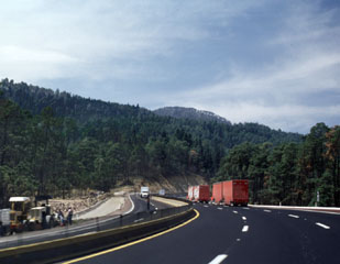 The Mexico City-Puebla highway skirts the northern margin of a voluminous lava flow from Papayo volcano, a lava dome whose rounded summit appears above the horizon to the SW above the trucks to the right. The dome produced massive lava flows that cover an area of 84 km2, with a volume of about 21 km3. The flows display transverse arcuate pressure ridges, and lateral levees.
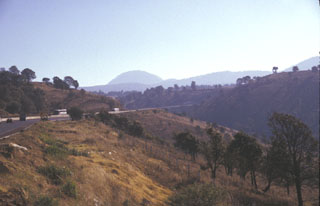 Papayo dome is seen in the center of this photo, a dacite lava dome along the crest of the Sierra Nevada 15 km north of Iztaccíhuatl volcano. The dome, seen here from the west, was the source of a voluminous postglacial lava flow that traveled 9.5 km to the WSW and more than 10 km to ENE. The Mexico City-Puebla highway (left) follows the northern margin of the lava flow, which covers an area of 84 km2.
 Papayo is the small rounded lava dome on the far-right horizon; the two peaks with snow-dusted summits on the horizon are Tláloc (left) and Telapón (center). This view looks to the NE across the Valley of Mexico from the flanks of the Chichinautzin range.
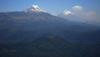 This photo looks south from Telapón volcano and shows the rounded Papayo lava dome in the foreground, with snow-capped Iztaccíhuatl (left) and Popocatépetl (right) in the background. These volcanoes, along with Telapón, and Tláloc stratovolcanoes, form a N-S-trending chain east of Mexico City and transverse to the Mexican Volcanic Belt trend.
There are no samples for Papayo in the Smithsonian's NMNH Department of Mineral Sciences Rock and Ore collection.
| Copernicus Browser | The Copernicus Browser replaced the Sentinel Hub Playground browser in 2023, to provide access to Earth observation archives from the Copernicus Data Space Ecosystem, the main distribution platform for data from the EU Copernicus missions. |
|
WOVOdat
Single Volcano View Temporal Evolution of Unrest Side by Side Volcanoes |
WOVOdat is a database of volcanic unrest; instrumentally and visually recorded changes in seismicity, ground deformation, gas emission, and other parameters from their normal baselines. It is sponsored by the World Organization of Volcano Observatories (WOVO) and presently hosted at the Earth Observatory of Singapore.
GVMID Data on Volcano Monitoring Infrastructure The Global Volcano Monitoring Infrastructure Database GVMID, is aimed at documenting and improving capabilities of volcano monitoring from the ground and space. GVMID should provide a snapshot and baseline view of the techniques and instrumentation that are in place at various volcanoes, which can be use by volcano observatories as reference to setup new monitoring system or improving networks at a specific volcano. These data will allow identification of what monitoring gaps exist, which can be then targeted by remote sensing infrastructure and future instrument deployments. |
| IRIS seismic stations/networks | Incorporated Research Institutions for Seismology (IRIS) Data Services map showing the location of seismic stations from all available networks (permanent or temporary) within a radius of 0.18° (about 20 km at mid-latitudes) from the given location of Papayo. Users can customize a variety of filters and options in the left panel. Note that if there are no stations are known the map will default to show the entire world with a "No data matched request" error notice. |
| UNAVCO GPS/GNSS stations | Geodetic Data Services map from UNAVCO showing the location of GPS/GNSS stations from all available networks (permanent or temporary) within a radius of 20 km from the given location of Papayo. Users can customize the data search based on station or network names, location, and time window. Requires Adobe Flash Player. |
| Large Eruptions of Papayo | Information about large Quaternary eruptions (VEI >= 4) is cataloged in the Large Magnitude Explosive Volcanic Eruptions (LaMEVE) database of the Volcano Global Risk Identification and Analysis Project (VOGRIPA). |
| EarthChem | EarthChem develops and maintains databases, software, and services that support the preservation, discovery, access and analysis of geochemical data, and facilitate their integration with the broad array of other available earth science parameters. EarthChem is operated by a joint team of disciplinary scientists, data scientists, data managers and information technology developers who are part of the NSF-funded data facility Integrated Earth Data Applications (IEDA). IEDA is a collaborative effort of EarthChem and the Marine Geoscience Data System (MGDS). |

