Earthquake swarm at historically inactive volcano
"An earthquake swarm occurred by surface faulting on 21 April in the Chinameca Complex, near Tecapa, a volcano with no known historic eruption. A magnitude 4.7 (mb) earthquake, the largest so far, occurred on 23 April . . . . Four days later, 27 April, during the peak activity (in terms of numbers of recorded and felt events per day), an 8 km-long graben formed on the NW flank of the volcano. The N40°W-striking graben is 0.8-1 km wide, with a vertical offset of 30 cm. Through 6 June, 170 earthquakes were felt in the area. A very preliminary analysis of the earthquake location data implies that activity began on a tectonic fault some 15 km NW of the volcanic summit, and moved nearer to the volcano at the time the graben formed. Since 3 June, 5-20 earthquakes per day were recorded by a high-gain seismograph station 50 km from the volcano, down from 300 events per day on 26, 27, and 28 April, and 21 and 23 May."
Information Contacts: J. González, Centro de Investigaciones Geotécnicas, San Salvador; D. Harlow, USGS.
The Global Volcanism Program has no Weekly Reports available for Tecapa.
Reports are organized chronologically and indexed below by Month/Year (Publication Volume:Number), and include a one-line summary. Click on the index link or scroll down to read the reports.
Earthquake swarm at historically inactive volcano
"An earthquake swarm occurred by surface faulting on 21 April in the Chinameca Complex, near Tecapa, a volcano with no known historic eruption. A magnitude 4.7 (mb) earthquake, the largest so far, occurred on 23 April . . . . Four days later, 27 April, during the peak activity (in terms of numbers of recorded and felt events per day), an 8 km-long graben formed on the NW flank of the volcano. The N40°W-striking graben is 0.8-1 km wide, with a vertical offset of 30 cm. Through 6 June, 170 earthquakes were felt in the area. A very preliminary analysis of the earthquake location data implies that activity began on a tectonic fault some 15 km NW of the volcanic summit, and moved nearer to the volcano at the time the graben formed. Since 3 June, 5-20 earthquakes per day were recorded by a high-gain seismograph station 50 km from the volcano, down from 300 events per day on 26, 27, and 28 April, and 21 and 23 May."
Information Contacts: J. González, Centro de Investigaciones Geotécnicas, San Salvador; D. Harlow, USGS.
|
|
||||||||||||||||||||||||||
There is data available for 0 confirmed eruptive period.
[ 1878 Oct 2 ] Uncertain Eruption
| Episode 1 | Eruption (Explosive / Effusive) | ||||
|---|---|---|---|---|
| 1878 Oct 2 - Unknown | Evidence from Unknown | |||
This compilation of synonyms and subsidiary features may not be comprehensive. Features are organized into four major categories: Cones, Craters, Domes, and Thermal Features. Synonyms of features appear indented below the primary name. In some cases additional feature type, elevation, or location details are provided.
Synonyms |
||||
| Berlín-Tecapa | ||||
Cones |
||||
| Feature Name | Feature Type | Elevation | Latitude | Longitude |
| Alegría, Cerro
Sabrana, La |
Cone | 1400 m | 13° 30' 0.00" N | 88° 29' 0.00" W |
| Ciega, Laguna | Stratovolcano | 1440 m | 13° 29' 0.00" N | 88° 29' 0.00" W |
| Palmas, Cerro las | Stratovolcano | 1528 m | 13° 29' 0.00" N | 88° 29' 0.00" W |
| Pelón, Cerro | Stratovolcano | 1440 m | 13° 29' 0.00" N | 88° 31' 0.00" W |
| Tecapa-Laguna de Alegría | Cone | 1593 m | 13° 30' 0.00" N | 88° 30' 0.00" W |
Craters |
||||
| Feature Name | Feature Type | Elevation | Latitude | Longitude |
| Berlín | Pleistocene caldera | |||
Domes |
||||
| Feature Name | Feature Type | Elevation | Latitude | Longitude |
| Black Crater | Dome | |||
Thermal |
||||
| Feature Name | Feature Type | Elevation | Latitude | Longitude |
| Alegría, Ausoles de la Laguna de | Thermal | 1300 m | 13° 29' 30.00" N | 88° 29' 30.00" W |
| Tronador, El | Thermal | |||
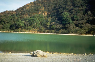 The Tecapa volcano summit contains the 600-m-wide Laguna de Alegría crater lake, seen here from the west. The 0.9 x 1.3 km crater is elongated in an E-W direction and lies about 300 m below the summit.
 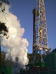 A drill rig towers above a well site at the Berlín geothermal area. The first exploratory well at Berlín was drilled in 1966 by the government of El Salvador, with assistance from the United Nations. Feasibility studies in the early 1980s were halted by the civil war, and production testing of wells was not completed until 1987. The first two 5 MW power plants came on line in 1992, and 25 MW wells at the Berlín 2 site went into operation in 1998 and 1999.
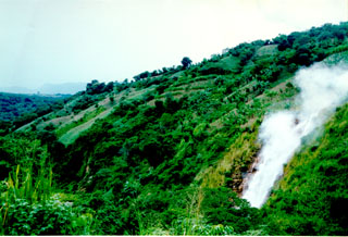 Steam rises above El Tronador, a fumarole along the lushly vegetated slopes of the Berlín geothermal area. The steam has temperatures of 105-107°C and begins condensing within 5 m of the vent. The intensity of geothermal activity at Tecapa has been stable during historical time.
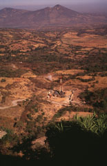 The Berlín geothermal area in the foreground is viewed from the SE on the flank of the Tecapa massif. The Pan-American highway traverses the base of the Tertiary volcanoes of Cerro Sihuatepeque (center) and Cerro Palacios (left) across the Río Lempa in the background.
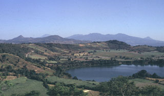 Laguna de Apastepeque in the foreground is one of several lake-filled maar craters in the Apastepeque volcanic field. The broad range in the distance to the right is the SE is the Tecapa massif. To the far right is the peak of Volcán Taburete. San Miguel volcano is in the midground to the left.
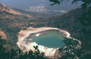 Laguna de Alegría is seen here from the summit of Tecapa volcano, looking SE with the town of Santiago de María in the background. The 600-m-wide crater lake lies about 300 m below the summit in this 1994 photo. Santiago de María is at the eastern end of the Tecapa volcanic complex, on the 900-m-high saddle between it and Cerro El Tigre volcano. Cerro Oromontique, on the flank of El Tigre volcano rise immediately to the right of the town.
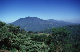 A westward view down the axis of a cluster of volcanoes between San Miguel and San Vicente volcanoes shows the eroded Pleistocene Cerro el Tigre volcano to the left and Tecapa to its right. San Vicente volcano is in the distance to the far-right.
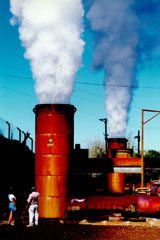 Steam pours from twin silencer towers at the Berlín 2 geothermal site. Geothermal fluids can flow from a well at the speed of sound, which resembles that of a jet engine to the field crew. The silencer drops the sound to a dull roar. Two 25 MW power plants came on line at Berlín 2 in 1998 and 1999. The two plants utilize both production and reinjection wells, and were expected (after operating and financial expenses) to save $56,000 in fuel costs per day.
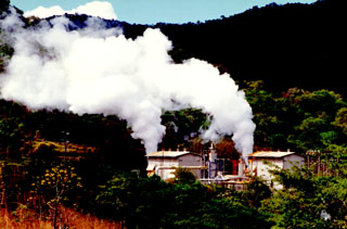 Steam clouds pour from the Berlín 2 well. The Berlín geothermal field on the NW flank of the Tecapa volcanic complex is one of the largest in El Salvador. The Berlín 2 site has an installed capacity of 55 MW with a potential of 55-150 MW. Measured well temperatures ranged from 240-300 degrees Centigrade.
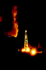 A night-time view shows a drill site at the Berlín geothermal area on the NW flank of Tecapa volcano. The Berlín Boca Pozo 1 site has an installed capacity of 10 MW and came on line in 1991. The El Tronador site began commercial operation in 1992 and generated 8 MW of power.
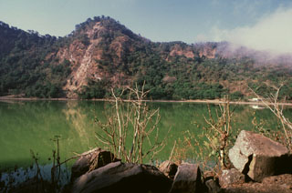 The Loma San Juan peak lies along the northern crater rim of Laguna de Alegría, a crater lake at the summit of Tecapa. Geothermal features are active along the rim of the crater lake and an area of hydrothermally altered clay containing up to 45% sulfur is found nearby.
 Tecapa is at the NW end of a cluster of volcanoes in eastern El Salvador between San Vicente and San Miguel, seen here from the west. The peaks on the horizon to the far left lie behind the Berlín caldera. Geothermal activity continues within the Tecapa volcanic complex and a producing geothermal plant is located at the Berlín geothermal field.
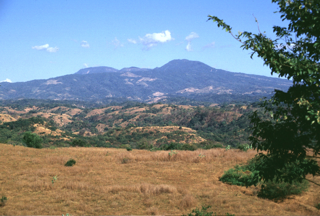
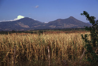 The Tecapa volcanic complex (left) and Volcan Taburete (right) are separated by a 800-m-high saddle. They are seen here from the SW rising more than 1100 m above the Pacific coastal plain and lie at the eastern end of a volcanic chain reaching to San Miguel volcano. A relatively young lava flow is found on the southern flank of Taburete volcano, although its age is not known precisely. Fumarolic activity continues at Tecapa, the site of a major geothermal project.
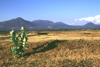 The rounded Volcan Taburete (far left) and the Tecapa volcanic massif rise to the NW above the Pacific coastal plain of El Salvador. The small Loma Pacha cone on the lower SE flank of Taburete (visible in the center of the image) produced a thick lava flow that traveled to SE. The rounded peak to the far right is Cerro Oromontique, a cone that erupted on the flank of El Tigre.
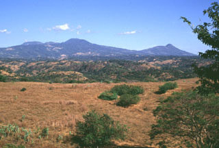 The Tecapa volcanic complex (left) and Volcán Taburete (right) rise to the east of the Río Lempa, which is hidden beyond the slope in the foreground. They are at the western end of the 40-km-long Tecapa-San Miguel volcano cluster in eastern El Salvador. Ignimbrites from a caldera-forming eruption at Tecapa were emplaced beyond the Río Lempa.
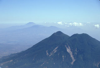 San Vicente is seen here in 2002 with landslide scarps that were produced during the January 2001 earthquake. The San Vicente area and towns at the base of the volcano were particularly affected by the tectonic earthquake and suffered extensive damage. The Tecapa volcanic complex and conical San Miguel volcano are in the distance.
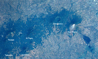 An E-W-trending chain of volcanoes extends about30 km across eastern El Salvador. The 2-km-wide Laguna Seca el Pacayal caldera is a prominent feature of Chinameca volcano. San Miguel is one of El Salvador's most active volcanoes; the dark area at the lower right is a lava flow from the 1819 eruption. The city of San Miguel is to the upper right.
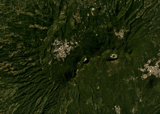 The Tecapa volcanic complex contains the cones and craters through the center of this November 2019 Planet Labs satellite image monthly mosaic (N is at the top; this image is approximately 12 km across). The craters in the NE-SW line from the one in the center in this image are Hoyon (center), Cerro Peylon, and Cerro Las Palmas; the Ausoles de la Laguna de Alegría thermal area is within the crater containing the lake towards the E.
There are no samples for Tecapa in the Smithsonian's NMNH Department of Mineral Sciences Rock and Ore collection.
| Copernicus Browser | The Copernicus Browser replaced the Sentinel Hub Playground browser in 2023, to provide access to Earth observation archives from the Copernicus Data Space Ecosystem, the main distribution platform for data from the EU Copernicus missions. |
| MIROVA | Middle InfraRed Observation of Volcanic Activity (MIROVA) is a near real time volcanic hot-spot detection system based on the analysis of MODIS (Moderate Resolution Imaging Spectroradiometer) data. In particular, MIROVA uses the Middle InfraRed Radiation (MIR), measured over target volcanoes, in order to detect, locate and measure the heat radiation sourced from volcanic activity. |
| MODVOLC Thermal Alerts | Using infrared satellite Moderate Resolution Imaging Spectroradiometer (MODIS) data, scientists at the Hawai'i Institute of Geophysics and Planetology, University of Hawai'i, developed an automated system called MODVOLC to map thermal hot-spots in near real time. For each MODIS image, the algorithm automatically scans each 1 km pixel within it to check for high-temperature hot-spots. When one is found the date, time, location, and intensity are recorded. MODIS looks at every square km of the Earth every 48 hours, once during the day and once during the night, and the presence of two MODIS sensors in space allows at least four hot-spot observations every two days. Each day updated global maps are compiled to display the locations of all hot spots detected in the previous 24 hours. There is a drop-down list with volcano names which allow users to 'zoom-in' and examine the distribution of hot-spots at a variety of spatial scales. |
|
WOVOdat
Single Volcano View Temporal Evolution of Unrest Side by Side Volcanoes |
WOVOdat is a database of volcanic unrest; instrumentally and visually recorded changes in seismicity, ground deformation, gas emission, and other parameters from their normal baselines. It is sponsored by the World Organization of Volcano Observatories (WOVO) and presently hosted at the Earth Observatory of Singapore.
GVMID Data on Volcano Monitoring Infrastructure The Global Volcano Monitoring Infrastructure Database GVMID, is aimed at documenting and improving capabilities of volcano monitoring from the ground and space. GVMID should provide a snapshot and baseline view of the techniques and instrumentation that are in place at various volcanoes, which can be use by volcano observatories as reference to setup new monitoring system or improving networks at a specific volcano. These data will allow identification of what monitoring gaps exist, which can be then targeted by remote sensing infrastructure and future instrument deployments. |
| Volcanic Hazard Maps | The IAVCEI Commission on Volcanic Hazards and Risk has a Volcanic Hazard Maps database designed to serve as a resource for hazard mappers (or other interested parties) to explore how common issues in hazard map development have been addressed at different volcanoes, in different countries, for different hazards, and for different intended audiences. In addition to the comprehensive, searchable Volcanic Hazard Maps Database, this website contains information about diversity of volcanic hazard maps, illustrated using examples from the database. This site is for educational purposes related to volcanic hazard maps. Hazard maps found on this website should not be used for emergency purposes. For the most recent, official hazard map for a particular volcano, please seek out the proper institutional authorities on the matter. |
| IRIS seismic stations/networks | Incorporated Research Institutions for Seismology (IRIS) Data Services map showing the location of seismic stations from all available networks (permanent or temporary) within a radius of 0.18° (about 20 km at mid-latitudes) from the given location of Tecapa. Users can customize a variety of filters and options in the left panel. Note that if there are no stations are known the map will default to show the entire world with a "No data matched request" error notice. |
| UNAVCO GPS/GNSS stations | Geodetic Data Services map from UNAVCO showing the location of GPS/GNSS stations from all available networks (permanent or temporary) within a radius of 20 km from the given location of Tecapa. Users can customize the data search based on station or network names, location, and time window. Requires Adobe Flash Player. |
| DECADE Data | The DECADE portal, still in the developmental stage, serves as an example of the proposed interoperability between The Smithsonian Institution's Global Volcanism Program, the Mapping Gas Emissions (MaGa) Database, and the EarthChem Geochemical Portal. The Deep Earth Carbon Degassing (DECADE) initiative seeks to use new and established technologies to determine accurate global fluxes of volcanic CO2 to the atmosphere, but installing CO2 monitoring networks on 20 of the world's 150 most actively degassing volcanoes. The group uses related laboratory-based studies (direct gas sampling and analysis, melt inclusions) to provide new data for direct degassing of deep earth carbon to the atmosphere. |
| Large Eruptions of Tecapa | Information about large Quaternary eruptions (VEI >= 4) is cataloged in the Large Magnitude Explosive Volcanic Eruptions (LaMEVE) database of the Volcano Global Risk Identification and Analysis Project (VOGRIPA). |
| EarthChem | EarthChem develops and maintains databases, software, and services that support the preservation, discovery, access and analysis of geochemical data, and facilitate their integration with the broad array of other available earth science parameters. EarthChem is operated by a joint team of disciplinary scientists, data scientists, data managers and information technology developers who are part of the NSF-funded data facility Integrated Earth Data Applications (IEDA). IEDA is a collaborative effort of EarthChem and the Marine Geoscience Data System (MGDS). |

