The Global Volcanism Program has no activity reports available for Conchagüita.
The Global Volcanism Program has no Weekly Reports available for Conchagüita.
The Global Volcanism Program has no Bulletin Reports available for Conchagüita.
|
|
||||||||||||||||||||||||||
There is data available for 0 confirmed eruptive period.
[ 1892 Oct 12 (?) - 1892 Oct 31 (?) ] Discredited Eruption
This compilation of synonyms and subsidiary features may not be comprehensive. Features are organized into four major categories: Cones, Craters, Domes, and Thermal Features. Synonyms of features appear indented below the primary name. In some cases additional feature type, elevation, or location details are provided.
Synonyms |
| Conchagua Island |
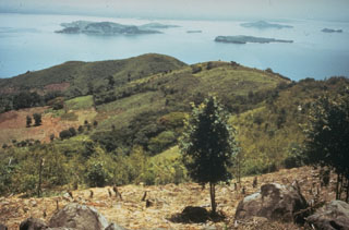 Islands dot the Gulf of Fonseca in this NE-looking view from Cerro el Havillal on Isla Conchagüita. Isla Conchagüita is a small, 4-km-wide island across a narrow strait from Conchagua volcano. Late-stage eruptions formed a small, sharp-topped cone with a 100-m-wide summit crater at the southern end of the island. A crescent-shaped crater open to the west is located at the northern end of the island.
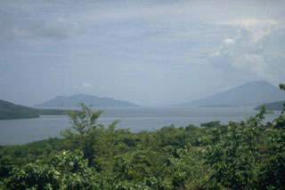 Conchagüita (left), an island in the Gulf of Fonseca, and Conchagua (right) a volcano on the Salvadoran mainland are seen here across the Gulf of Fonseca from the NE on the island of Zacate Grande in Honduras. Both Conchagüita and Conchagua are extensively eroded, but a historical eruption was reported from Conchagüita. The NW flank of Isla El Tigre volcano forms the ridge extending into the sea at the extreme left.
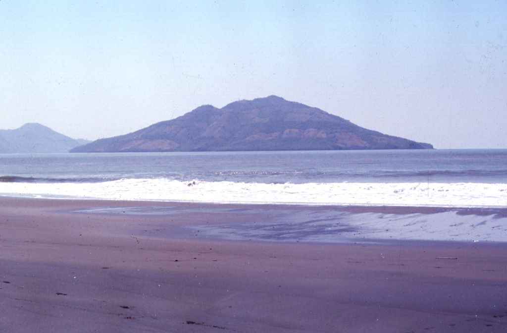
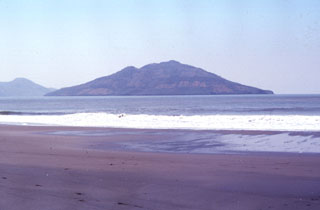 Conchagüita volcano occupies a small, 4-km-wide island in the Gulf of Fonseca across a narrow strait from Conchagua volcano. Conchagüita is seen here from Punta El Chiquirín, the easternmost point on the Salvadoran mainland. Late-stage eruptions formed a small, sharp-topped cone with a 100-m-wide summit crater at the southern end of the low 550-m-high island. Minor ash emissions in 1892 marked the only reported historical eruption from Conchagüita. Meanguera Island can be seen beyond Conchagüita at the left.
 Conchagüita (right) and Meanguera (left) volcanoes lie across a narrow strait from Punta El Chiquirín in eastern El Salvador. Conchagüita is the youngest of the two small volcanic islands in the Gulf of Fonseca and had an historical eruption in 1892. The more eroded Isla Meanguera volcano ceased activity during the Pleistocene.
There are no samples for Conchagüita in the Smithsonian's NMNH Department of Mineral Sciences Rock and Ore collection.
| Copernicus Browser | The Copernicus Browser replaced the Sentinel Hub Playground browser in 2023, to provide access to Earth observation archives from the Copernicus Data Space Ecosystem, the main distribution platform for data from the EU Copernicus missions. |
|
WOVOdat
Single Volcano View Temporal Evolution of Unrest Side by Side Volcanoes |
WOVOdat is a database of volcanic unrest; instrumentally and visually recorded changes in seismicity, ground deformation, gas emission, and other parameters from their normal baselines. It is sponsored by the World Organization of Volcano Observatories (WOVO) and presently hosted at the Earth Observatory of Singapore.
GVMID Data on Volcano Monitoring Infrastructure The Global Volcano Monitoring Infrastructure Database GVMID, is aimed at documenting and improving capabilities of volcano monitoring from the ground and space. GVMID should provide a snapshot and baseline view of the techniques and instrumentation that are in place at various volcanoes, which can be use by volcano observatories as reference to setup new monitoring system or improving networks at a specific volcano. These data will allow identification of what monitoring gaps exist, which can be then targeted by remote sensing infrastructure and future instrument deployments. |
| IRIS seismic stations/networks | Incorporated Research Institutions for Seismology (IRIS) Data Services map showing the location of seismic stations from all available networks (permanent or temporary) within a radius of 0.18° (about 20 km at mid-latitudes) from the given location of Conchagüita. Users can customize a variety of filters and options in the left panel. Note that if there are no stations are known the map will default to show the entire world with a "No data matched request" error notice. |
| UNAVCO GPS/GNSS stations | Geodetic Data Services map from UNAVCO showing the location of GPS/GNSS stations from all available networks (permanent or temporary) within a radius of 20 km from the given location of Conchagüita. Users can customize the data search based on station or network names, location, and time window. Requires Adobe Flash Player. |
| Large Eruptions of Conchagüita | Information about large Quaternary eruptions (VEI >= 4) is cataloged in the Large Magnitude Explosive Volcanic Eruptions (LaMEVE) database of the Volcano Global Risk Identification and Analysis Project (VOGRIPA). |
| EarthChem | EarthChem develops and maintains databases, software, and services that support the preservation, discovery, access and analysis of geochemical data, and facilitate their integration with the broad array of other available earth science parameters. EarthChem is operated by a joint team of disciplinary scientists, data scientists, data managers and information technology developers who are part of the NSF-funded data facility Integrated Earth Data Applications (IEDA). IEDA is a collaborative effort of EarthChem and the Marine Geoscience Data System (MGDS). |

