The Global Volcanism Program has no activity reports available for Malpaisillo.
The Global Volcanism Program has no Weekly Reports available for Malpaisillo.
The Global Volcanism Program has no Bulletin Reports available for Malpaisillo.
|
|
||||||||||||||||||
The Global Volcanism Program is not aware of any Holocene eruptions from Malpaisillo. If this volcano has had large eruptions (VEI >= 4) prior to 12,000 years ago, information might be found on the Malpaisillo page in the LaMEVE (Large Magnitude Explosive Volcanic Eruptions) database, a part of the Volcano Global Risk Identification and Analysis Project (VOGRIPA).
This compilation of synonyms and subsidiary features may not be comprehensive. Features are organized into four major categories: Cones, Craters, Domes, and Thermal Features. Synonyms of features appear indented below the primary name. In some cases additional feature type, elevation, or location details are provided.
Synonyms |
| Chúcaro, Cerro el |
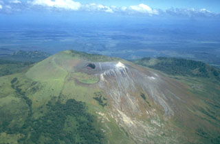 Las Pilas volcano is seen here in an aerial view from the south, with the dramatic El Hoyo pit crater below the summit at the left center. The arcuate ridge at the right beyond Las Pilas is the NE rim of a large crater cutting the older Cerro el Picacho volcano. The flat area in the background beyond Cerro el Picacho on the floor of the Nicaraguan depression is the Malpaisillo pyroclastic shield volcano.
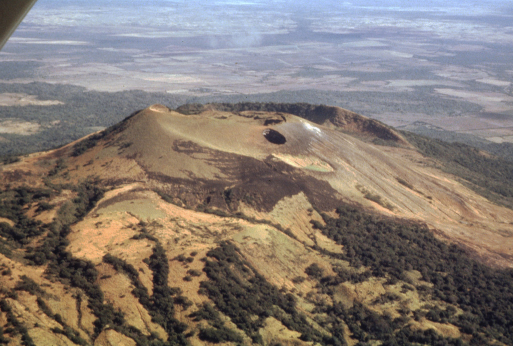
  The flat light-colored area at the top of the photo beyond Las Pilas volcano in the foreground is the Malpaisillo caldera. This large but topographically indistinct pyroclastic shield volcano lies in the Nicaraguan depression NE of Las Pilas volcano and NNW of Momotombo volcano. Formation of the 10-km-wide Malpaisillo caldera produced extensively dissected dacitic airfall and ignimbrite deposits that extend across the graben east of the Marrabios Range and reach into Lake Managua to the SE.
 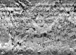 The flat-lying floor of the topographically indistinct 10-km-wide Malpaisillo pyroclastic shield volcano lies in the center of this radar image of the Nicaraguan depression. The Malpaisillo road crosses the image diagonally from the SW to the NE, and the town of Malpaisillo is outlined in black below the road at the left-center. Extensively dissected dacitic airfall and ignimbrite deposits are seen north of the 10-km-wide caldera, and lava flows from Las Pilas complex at the lower left lie SW of the caldera.
 There are no samples for Malpaisillo in the Smithsonian's NMNH Department of Mineral Sciences Rock and Ore collection.
| Copernicus Browser | The Copernicus Browser replaced the Sentinel Hub Playground browser in 2023, to provide access to Earth observation archives from the Copernicus Data Space Ecosystem, the main distribution platform for data from the EU Copernicus missions. |
|
WOVOdat
Single Volcano View Temporal Evolution of Unrest Side by Side Volcanoes |
WOVOdat is a database of volcanic unrest; instrumentally and visually recorded changes in seismicity, ground deformation, gas emission, and other parameters from their normal baselines. It is sponsored by the World Organization of Volcano Observatories (WOVO) and presently hosted at the Earth Observatory of Singapore.
GVMID Data on Volcano Monitoring Infrastructure The Global Volcano Monitoring Infrastructure Database GVMID, is aimed at documenting and improving capabilities of volcano monitoring from the ground and space. GVMID should provide a snapshot and baseline view of the techniques and instrumentation that are in place at various volcanoes, which can be use by volcano observatories as reference to setup new monitoring system or improving networks at a specific volcano. These data will allow identification of what monitoring gaps exist, which can be then targeted by remote sensing infrastructure and future instrument deployments. |
| IRIS seismic stations/networks | Incorporated Research Institutions for Seismology (IRIS) Data Services map showing the location of seismic stations from all available networks (permanent or temporary) within a radius of 0.18° (about 20 km at mid-latitudes) from the given location of Malpaisillo. Users can customize a variety of filters and options in the left panel. Note that if there are no stations are known the map will default to show the entire world with a "No data matched request" error notice. |
| UNAVCO GPS/GNSS stations | Geodetic Data Services map from UNAVCO showing the location of GPS/GNSS stations from all available networks (permanent or temporary) within a radius of 20 km from the given location of Malpaisillo. Users can customize the data search based on station or network names, location, and time window. Requires Adobe Flash Player. |
| Large Eruptions of Malpaisillo | Information about large Quaternary eruptions (VEI >= 4) is cataloged in the Large Magnitude Explosive Volcanic Eruptions (LaMEVE) database of the Volcano Global Risk Identification and Analysis Project (VOGRIPA). |
| EarthChem | EarthChem develops and maintains databases, software, and services that support the preservation, discovery, access and analysis of geochemical data, and facilitate their integration with the broad array of other available earth science parameters. EarthChem is operated by a joint team of disciplinary scientists, data scientists, data managers and information technology developers who are part of the NSF-funded data facility Integrated Earth Data Applications (IEDA). IEDA is a collaborative effort of EarthChem and the Marine Geoscience Data System (MGDS). |

