Nicaragua Volcanoes
A map display is currently under development.
Nicaragua has 13 Holocene volcanoes. Note that as a scientific organization we provide these listings for informational purposes only, with no international legal or policy implications. Volcanoes will be included on this list if they are within the boundaries of a country, on a shared boundary or area, in a remote territory, or within a maritime Exclusive Economic Zone. Bolded volcanoes have erupted within the past 20 years. Suggestions and data updates are always welcome ().
| Volcano Name | Last Eruption | Volcanic Region | Primary Landform |
|---|---|---|---|
| Apoyeque | 50 BCE | Central America Volcanic Arc | Caldera |
| Concepcion | 2024 CE | Central America Volcanic Arc | Composite |
| Cosiguina | 1859 CE | Central America Volcanic Arc | Composite |
| Granada | Unknown - Evidence Credible | Central America Volcanic Arc | Cluster |
| Las Pilas-El Hoyo Complex | 1954 CE | Central America Volcanic Arc | Composite |
| Masaya | 2025 CE | Central America Volcanic Arc | Caldera |
| Mombacho | Unknown - Unrest / Holocene | Central America Volcanic Arc | Composite |
| Momotombo | 2016 CE | Central America Volcanic Arc | Composite |
| Cerro Negro | 1999 CE | Central America Volcanic Arc | Minor |
| Nejapa-Miraflores | 1060 CE | Central America Volcanic Arc | Cluster |
| San Cristobal | 2024 CE | Central America Volcanic Arc | Composite |
| Telica | 2025 CE | Central America Volcanic Arc | Composite |
| Zapatera | Unknown - Evidence Credible | Central America Volcanic Arc | Shield |
Chronological listing of known Holocene eruptions (confirmed or uncertain) from volcanoes in Nicaragua. Bolded eruptions indicate continuing activity.
| Volcano Name | Start Date | Stop Date | Certainty | VEI | Evidence |
|---|---|---|---|---|---|
| Telica | 2025 Jan 11 | 2025 May 2 (continuing) | Confirmed | Observations: Reported | |
| San Cristobal | 2024 Jul 5 | 2024 Jul 7 | Confirmed | Observations: Reported | |
| Concepcion | 2024 May 16 | 2024 May 16 | Confirmed | Observations: Reported | |
| San Cristobal | 2023 Jul 5 | 2023 Jul 5 | Confirmed | 1 | Observations: Reported |
| Telica | 2021 Apr 21 | 2022 Mar 29 | Confirmed | 1 | Observations: Reported |
| San Cristobal | 2020 Dec 27 (?) | 2022 Jun 26 | Confirmed | 2 | Observations: Reported |
| Telica | 2020 Jul 20 | 2020 Dec 9 | Confirmed | 1 | Observations: Reported |
| San Cristobal | 2019 Mar 4 | 2019 Mar 4 | Confirmed | 1 | Observations: Reported |
| Telica | 2018 Jun 21 | 2018 Aug 15 | Confirmed | 1 | Observations: Reported |
| San Cristobal | 2018 Apr 22 | 2018 Apr 22 | Confirmed | 1 | Observations: Reported |
| San Cristobal | 2017 Aug 18 | 2017 Nov 11 | Confirmed | 2 | Observations: Reported |
| San Cristobal | 2017 Feb 18 | 2017 Apr 19 | Confirmed | 1 | Observations: Reported |
| San Cristobal | 2016 Apr 22 | 2016 Apr 22 | Confirmed | 2 | Observations: Reported |
| Momotombo | 2015 Dec 1 | 2016 Apr 7 | Confirmed | 2 | Observations: Reported |
| Masaya | 2015 Oct 3 | 2025 May 2 (continuing) | Confirmed | 1 | Observations: Reported |
| Telica | 2015 Sep 23 | 2016 May 11 | Confirmed | 2 | Observations: Reported |
| Telica | 2015 May 7 | 2015 May 28 | Confirmed | 2 | Observations: Reported |
| San Cristobal | 2015 Mar 5 | 2015 Jun 12 | Confirmed | 2 | Observations: Reported |
| San Cristobal | 2014 Jul 20 | 2014 Oct 1 | Confirmed | 2 | Observations: Reported |
| San Cristobal | 2014 Feb 4 | 2014 Apr 12 | Confirmed | 1 | Observations: Reported |
| Telica | 2013 Sep 25 | 2013 Sep 25 | Confirmed | 1 | Observations: Reported |
| San Cristobal | 2013 Jun 7 | 2013 Jun 7 | Confirmed | 1 | Observations: Reported |
| Masaya | [2013 Apr 11] | [2013 Apr 26] | Uncertain | ||
| San Cristobal | 2012 Dec 26 | 2012 Dec 28 | Confirmed | 2 | Observations: Reported |
| San Cristobal | 2012 Sep 8 | 2012 Sep 15 | Confirmed | 2 | Observations: Reported |
| Masaya | 2012 Apr 30 | 2012 Jun 8 | Confirmed | 2 | Observations: Reported |
| San Cristobal | 2011 Aug 21 (?) | 2011 Oct 23 | Confirmed | 1 | Observations: Reported |
| Telica | 2011 Mar 7 | 2011 Jun 14 | Confirmed | 2 | Observations: Reported |
| San Cristobal | 2010 Jun 9 | 2011 Jan 13 | Confirmed | 2 | Observations: Reported |
| Concepcion | 2009 Dec 11 | 2011 Mar 12 | Confirmed | 1 | Observations: Reported |
| San Cristobal | 2009 Sep 6 | 2009 Dec 26 (?) | Confirmed | 2 | Observations: Reported |
| San Cristobal | 2008 Nov 21 | 2008 Nov 21 | Confirmed | 1 | Observations: Reported |
| Concepcion | 2008 Jul 30 | 2008 Jul 30 | Confirmed | 1 | Observations: Reported |
| Telica | 2008 Jul 5 ± 4 days | 2008 Jul 5 ± 4 days | Confirmed | 1 | Observations: Reported |
| San Cristobal | 2008 Jun 22 | 2008 Aug 5 ± 4 days | Confirmed | 1 | Observations: Reported |
| Masaya | 2008 Apr 29 | 2008 Dec 17 (?) | Confirmed | 1 | Observations: Reported |
| Concepcion | 2007 Nov 24 | 2007 Dec 20 | Confirmed | 2 | Observations: Reported |
| San Cristobal | 2007 Nov 8 (on or before) | Unknown | Confirmed | 1 | Observations: Reported |
| Telica | 2007 Oct 28 ± 3 days | 2008 Feb 18 | Confirmed | 1 | Observations: Reported |
| Telica | [2007 Jun 12] | [2007 Jun 12] | Uncertain | ||
| Concepcion | 2007 Feb 9 | 2007 Jul 10 | Confirmed | 1 | Observations: Reported |
| Telica | 2006 Dec 11 (?) | 2007 Feb 17 | Confirmed | 1 | Observations: Reported |
| Concepcion | 2006 Sep 1 | 2006 Sep 21 | Confirmed | 2 | Observations: Reported |
| Masaya | 2006 Aug 4 | 2006 Oct 25 (?) | Confirmed | 1 | Observations: Reported |
| Telica | 2006 Aug 4 | 2006 Aug 6 | Confirmed | 1 | Observations: Reported |
| San Cristobal | 2005 Nov 13 | 2006 May 27 | Confirmed | 2 | Observations: Reported |
| Concepcion | 2005 Jul 28 | 2005 Nov 10 | Confirmed | 2 | Observations: Reported |
| Masaya | 2005 Mar 4 (?) | 2005 Mar 30 (?) | Confirmed | 1 | Observations: Reported |
| San Cristobal | 2004 Dec 3 | 2004 Dec 7 | Confirmed | 1 | Observations: Reported |
| Telica | 2004 Nov 5 | 2005 Jan 29 | Confirmed | 1 | Observations: Reported |
| Masaya | [2004 Jul 4] | [2004 Jul 4] | Uncertain | ||
| Telica | 2004 Mar 31 | 2004 Mar 31 | Confirmed | 1 | Observations: Reported |
| Masaya | 2003 Sep 22 (on or before) | 2003 Dec 12 (?) | Confirmed | 1 | Observations: Reported |
| San Cristobal | 2003 Jun 17 | 2004 Jun 13 | Confirmed | 1 | Observations: Reported |
| Telica | 2002 Oct 17 | Unknown | Confirmed | 0 | Observations: Reported |
| San Cristobal | 2002 May 29 | 2002 Dec 16 (?) | Confirmed | 1 | Observations: Reported |
| San Cristobal | 2001 May 11 (?) | 2001 Dec 9 (?) | Confirmed | 1 | Observations: Reported |
| Masaya | 2001 Apr 23 | 2001 Apr 25 (?) | Confirmed | 1 | Observations: Reported |
| Telica | 2001 Jan 17 | 2001 Dec 19 (?) | Confirmed | 1 | Observations: Reported |
| Concepcion | 1999 Dec 27 | 1999 Dec 29 (?) | Confirmed | 1 | Observations: Reported |
| Maderas | [1999 Dec 27] | [Unknown] | Uncertain | ||
| Masaya | 1999 Nov 22 | 2000 Mar 2 (?) | Confirmed | 1 | Observations: Reported |
| Cerro Negro | 1999 Aug 5 | 1999 Aug 7 | Confirmed | 2 | Observations: Reported |
| Telica | 1999 May 21 | 2000 Sep 6 | Confirmed | 2 | Observations: Reported |
| San Cristobal | 1999 May 1 ± 180 days | 2000 Jun 16 ± 15 days | Confirmed | 2 | Observations: Reported |
| Masaya | 1998 Sep 14 | 1998 Sep 14 | Confirmed | 1 | Observations: Reported |
| Masaya | 1997 Jun 3 (?) | 1997 Nov 17 | Confirmed | 1 | Observations: Reported |
| San Cristobal | 1997 May 19 (?) | 1997 Jul 7 (on or after) | Confirmed | 1 | Observations: Reported |
| Masaya | 1996 Dec 5 | 1996 Dec 5 | Confirmed | 1 | Observations: Reported |
| Maderas | [1996 Sep 27] | [Unknown] | Uncertain | ||
| Cerro Negro | 1995 May 29 | 1995 Dec 6 | Confirmed | 2 | Observations: Reported |
| Telica | 1994 Jul 31 | 1994 Aug 12 | Confirmed | 2 | Observations: Reported |
| Masaya | 1993 Jun 16 | 1994 Nov 16 (on or after) ± 15 days | Confirmed | 1 | Observations: Reported |
| Cerro Negro | 1992 Apr 9 | 1992 Apr 14 | Confirmed | 3 | Observations: Reported |
| Masaya | 1989 Feb 20 | 1989 Nov 16 ± 15 days | Confirmed | 1 | Observations: Reported |
| Concepcion | 1988 Jun 16 ± 15 days | Unknown | Confirmed | 2 | Observations: Reported |
| Telica | 1987 Nov 16 ± 15 days | 1987 Nov 16 ± 15 days | Confirmed | 1 | Observations: Reported |
| San Cristobal | [1987 Nov 16 ± 15 days] | [Unknown] | Uncertain | ||
| Masaya | 1987 Feb 15 | 1987 Feb 22 (on or after) | Confirmed | 1 | Observations: Reported |
| Concepcion | 1985 Dec 2 ± 1 days | 1986 Apr 20 (?) | Confirmed | 1 | Observations: Reported |
| San Cristobal | [1985 Sep 2] | [Unknown] | Uncertain | ||
| Concepcion | 1984 Dec 16 ± 15 days | 1985 Jan 2 | Confirmed | 2 | Observations: Reported |
| Concepcion | 1983 Mar 16 | 1983 Mar 25 | Confirmed | 2 | Observations: Reported |
| Concepcion | 1982 Jan 15 ± 5 days | 1982 Feb 14 ± 5 days | Confirmed | 2 | Observations: Reported |
| Telica | 1981 Nov 25 ± 5 days | 1982 Mar 2 | Confirmed | 2 | Observations: Reported |
| Telica | 1981 Feb 16 (?) ± 15 days | Unknown | Confirmed | 1 | Observations: Reported |
| Concepcion | 1978 Mar 30 (on or before) | 1978 May 16 (on or after) ± 15 days | Confirmed | 2 | Observations: Reported |
| San Cristobal | 1977 Oct 16 | 1977 Oct 16 | Confirmed | 2 | Observations: Reported |
| Concepcion | 1977 Apr 4 | 1977 May 3 | Confirmed | 2 | Observations: Reported |
| Telica | 1976 Nov 3 | 1978 Jan 16 (on or after) ± 15 days | Confirmed | 1 | Observations: Reported |
| San Cristobal | 1976 Aug 29 | 1976 Aug 29 | Confirmed | 1 | Observations: Reported |
| San Cristobal | 1976 Mar 9 | 1976 Mar 16 | Confirmed | 1 | Observations: Reported |
| Telica | 1975 May 16 ± 15 days | 1976 Mar 16 ± 15 days | Confirmed | 0 | Observations: Reported |
| Concepcion | 1973 Dec 24 | 1974 Jan 12 | Confirmed | 2 | Observations: Reported |
| San Cristobal | 1971 May 3 | 1971 Jul 5 ± 4 days | Confirmed | 1 | Observations: Reported |
| Cerro Negro | 1971 Feb 3 | 1971 Feb 14 | Confirmed | 3 | Observations: Reported |
| Cerro Negro | 1969 Dec 19 | 1969 Dec 29 | Confirmed | 1 | Observations: Reported |
| Telica | 1969 Feb 11 | 1971 Dec 16 (on or after) ± 15 days | Confirmed | 2 | Observations: Reported |
| Cerro Negro | 1968 Oct 23 | 1968 Dec 10 | Confirmed | 3 | Observations: Reported |
| Telica | 1966 Jun 16 ± 15 days | 1966 Jun 16 ± 15 days | Confirmed | 1 | Observations: Reported |
| Masaya | 1965 Oct 10 (?) | 1985 Apr 16 (?) ± 15 days | Confirmed | 1 | Observations: Reported |
| Telica | 1965 Jan 16 | 1965 Jan 28 | Confirmed | 1 | Observations: Reported |
| Cerro Negro | [1964 Jul 2 ± 182 days] | [Unknown] | Uncertain | ||
| Concepcion | 1963 May 9 | Unknown | Confirmed | 1 | Observations: Reported |
| Cerro Negro | 1963 Mar 16 ± 15 days | Unknown | Confirmed | 1 | Observations: Reported |
| Concepcion | 1962 Jun 16 ± 15 days | 1962 Jun 16 ± 15 days | Confirmed | 2 | Observations: Reported |
| Cerro Negro | 1962 Mar 21 | 1962 Apr 16 (?) ± 15 days | Confirmed | 2 | Observations: Reported |
| Telica | 1962 Jan 16 ± 15 days | 1962 Jan 16 ± 15 days | Confirmed | 1 | Observations: Reported |
| Concepcion | [1961 Nov 28] | [1961 Dec 16 ± 15 days] | Uncertain | ||
| Cerro Negro | 1961 Oct 25 | Unknown | Confirmed | 1 | Observations: Reported |
| Cerro Negro | 1960 Sep 28 | 1960 Dec 26 ± 5 days | Confirmed | 3 | Observations: Reported |
| Cerro Negro | 1957 Sep 4 | 1957 Sep 24 | Confirmed | 2 | Observations: Reported |
| Concepcion | 1957 Mar 27 | 1957 Jul 16 ± 15 days | Confirmed | 2 | Observations: Reported |
| Las Pilas-El Hoyo Complex | 1954 Oct 29 | 1954 Oct 31 | Confirmed | 2 | Observations: Reported |
| Cerro Negro | 1954 Feb 16 ± 15 days | 1954 Feb 16 ± 15 days | Confirmed | 2 | Observations: Reported |
| Las Pilas-El Hoyo Complex | 1952 Oct 23 | 1952 Dec 16 ± 15 days | Confirmed | 1 | Observations: Reported |
| Concepcion | 1951 Jul 16 ± 15 days | 1955 May 16 ± 15 days | Confirmed | 2 | Observations: Reported |
| Telica | 1951 Jul 15 ± 45 days | 1951 Oct 15 ± 5 days | Confirmed | 2 | Observations: Reported |
| Cerro Negro | 1950 Nov 21 | 1950 Dec 17 | Confirmed | 3 | Observations: Reported |
| Cerro Negro | 1949 Jun | 1949 Jun | Confirmed | 2 | Observations: Reported |
| Masaya | 1948 Sep | 1948 Sep | Confirmed | 1 | Observations: Reported |
| Telica | 1948 Jun | 1949 Nov | Confirmed | 2 | Observations: Reported |
| Cerro Negro | 1948 Mar 31 | Unknown | Confirmed | 2 | Observations: Reported |
| Telica | 1948 Jan | 1948 Jan | Confirmed | 2 | Observations: Reported |
| Concepcion | 1948 | 1950 Jul 2 ± 182 days | Confirmed | 1 | Observations: Reported |
| Cerro Negro | 1947 Jul 9 | 1947 Aug 2 | Confirmed | 3 | Observations: Reported |
| Masaya | 1946 Jun | 1947 Dec (?) | Confirmed | 1 | Observations: Reported |
| Telica | 1946 Apr | 1946 Aug | Confirmed | 2 | Observations: Reported |
| Concepcion | 1944 Apr | 1945 Dec | Confirmed | 2 | Observations: Reported |
| Telica | 1943 Dec | 1944 Apr | Confirmed | 2 | Observations: Reported |
| Telica | [1941] | [Unknown] | Uncertain | ||
| Telica | 1940 Jun | 1940 Oct | Confirmed | 2 | Observations: Reported |
| Telica | 1939 Nov | 1939 Nov | Confirmed | 2 | Observations: Reported |
| Telica | 1939 Jan | 1939 Jun | Confirmed | 2 | Observations: Reported |
| Telica | 1937 Nov | 1938 Aug | Confirmed | 2 | Observations: Reported |
| Concepcion | 1935 Feb | 1935 Feb | Confirmed | 2 | Observations: Reported |
| Telica | 1934 Jan | Unknown | Confirmed | 2 | Observations: Reported |
| Concepcion | 1929 Aug | 1929 Oct | Confirmed | 2 | Observations: Reported |
| Cerro Negro | 1929 Feb 10 | 1929 Mar | Confirmed | 2 | Observations: Reported |
| Telica | 1929 Jan | 1929 Jan | Confirmed | 1 | Observations: Reported |
| Concepcion | 1928 Jan 25 | Unknown | Confirmed | 2 | Observations: Reported |
| Telica | 1928 | Unknown | Confirmed | 2 | Observations: Reported |
| Telica | 1927 Aug | 1927 Nov | Confirmed | 2 | Observations: Reported |
| Masaya | 1925 Apr | Unknown | Confirmed | 2 | Observations: Reported |
| Cerro Negro | 1923 Oct 23 | 1923 Dec 11 | Confirmed | 3 | Observations: Reported |
| Concepcion | 1921 Dec | 1926 May | Confirmed | 2 | Observations: Reported |
| Telica | [1919 Oct 26 ± 5 days] | [Unknown] | Uncertain | ||
| Cerro Negro | 1919 Jun 20 | 1919 Jun 30 | Confirmed | 2 | Observations: Reported |
| Masaya | 1919 | 1924 | Confirmed | 2 | Observations: Reported |
| Momotombo | [1918 Apr 16 ± 15 days] | [Unknown] | Uncertain | ||
| Masaya | 1918 Jan | Unknown | Confirmed | 1 | Observations: Reported |
| Concepcion | 1918 Jan | 1919 Jul | Confirmed | 2 | Observations: Reported |
| Telica | [1918 Jan] | [Unknown] | Uncertain | ||
| Cerro Negro | 1914 Oct 28 | 1914 Nov 3 | Confirmed | 2 | Observations: Reported |
| Masaya | 1913 Jul 12 | Unknown | Confirmed | 1 | Observations: Reported |
| Telica | 1907 Nov | Unknown | Confirmed | 2 | Observations: Reported |
| Concepcion | 1907 Sep | 1910 | Confirmed | 2 | Observations: Reported |
| Masaya | 1906 Jan 2 | 1906 Jan 9 (on or after) | Confirmed | 2 | Observations: Reported |
| Momotombo | 1905 Jan 16 | 1905 Jan 21 | Confirmed | 2 | Observations: Reported |
| Masaya | 1904 May | 1904 Jun | Confirmed | 2 | Observations: Reported |
| Masaya | 1902 Jul 15 | 1903 Nov | Confirmed | 2 | Observations: Reported |
| Momotombo | 1902 Mar 31 ± 30 days | Unknown | Confirmed | 2 | Observations: Reported |
| Concepcion | 1902 | Unknown | Confirmed | 2 | Observations: Reported |
| Cerro Negro | 1899 Nov 22 | 1899 Nov 29 ± 1 days | Confirmed | 2 | Observations: Reported |
| Concepcion | 1891 Apr | 1891 Apr | Confirmed | 2 | Observations: Reported |
| Momotombo | 1886 May 19 (?) | 1887 (?) | Confirmed | 2 | Observations: Reported |
| Momotombo | [1885 Oct] | [Unknown] | Uncertain | ||
| Concepcion | 1884 | 1886 | Confirmed | 2 | Observations: Reported |
| Concepcion | 1883 Apr 5 ± 4 days | 1883 Jun 30 | Confirmed | 2 | Observations: Reported |
| Momotombo | 1882 Sep 9 | Unknown | Confirmed | 2 | Observations: Reported |
| Momotombo | 1878 Oct 14 (?) | Unknown | Confirmed | 2 | Observations: Reported |
| Momotombo | 1870 | Unknown | Confirmed | 2 | Observations: Reported |
| Cerro Negro | 1867 Nov 14 | 1867 Nov 30 | Confirmed | 2 | Observations: Reported |
| Cosiguina | 1859 Aug 25 | Unknown | Confirmed | Observations: Reported | |
| Masaya | 1858 Nov 10 | 1859 Mar 27 | Confirmed | 2 | Observations: Reported |
| Masaya | [1858 Apr] | [Unknown] | Uncertain | ||
| Momotombo | 1858 | 1866 | Confirmed | 2 | Observations: Reported |
| Masaya | 1856 Dec | 1857 Jan | Confirmed | 2 | Observations: Reported |
| Momotombo | 1854 Feb | 1854 Mar | Confirmed | 2 | Observations: Reported |
| Masaya | 1853 Apr 9 (?) | 1853 Sep 15 (on or after) | Confirmed | 1 | Observations: Reported |
| Cosiguina | 1852 Dec | Unknown | Confirmed | 2 | Observations: Reported |
| Masaya | 1852 Jun | 1852 Jul | Confirmed | 2 | Observations: Reported |
| Momotombo | 1852 | Unknown | Confirmed | 2 | Observations: Reported |
| Cerro Negro | 1850 Apr 13 | 1850 May 27 | Confirmed | 2 | Observations: Reported |
| Momotombo | 1849 | Unknown | Confirmed | 2 | Observations: Reported |
| Cosiguina | 1835 Jan 20 | 1835 Jan 25 (?) | Confirmed | 5 | Observations: Reported |
| Cosiguina | [1809 Mar 28] | [1809 Mar 31 ± 1 days] | Uncertain | ||
| Concepcion | [1800 ± 50 years] | [Unknown] | Uncertain | ||
| Telica | 1791 Jan 24 | Unknown | Confirmed | Observations: Reported | |
| Masaya | 1772 Mar 16 | 1772 Mar 25 (?) | Confirmed | 2 | Observations: Reported |
| Telica | 1765 | Unknown | Confirmed | 2 | Observations: Reported |
| Momotombo | 1764 | Unknown | Confirmed | 2 | Observations: Reported |
| Telica | [1743 Apr] | [Unknown] | Uncertain | ||
| Momotombo | 1736 | Unknown | Confirmed | 2 | Observations: Reported |
| Cosiguina | 1709 (?) | Unknown | Confirmed | Observations: Reported | |
| Telica | 1685 Aug | Unknown | Confirmed | 2 | Observations: Reported |
| San Cristobal | 1685 Aug | Unknown | Confirmed | 2 | Observations: Reported |
| San Cristobal | 1684 Jul | Unknown | Confirmed | 2 | Observations: Reported |
| San Cristobal | 1680 | Unknown | Confirmed | 2 | Observations: Reported |
| Masaya | 1670 | Unknown | Confirmed | 3 | Observations: Reported |
| Masaya | [1613] | [Unknown] | Uncertain | ||
| San Cristobal | [1613] | [Unknown] | Uncertain | ||
| Telica | 1613 | Unknown | Confirmed | 2 | Observations: Reported |
| Momotombo | [1609] | [Unknown] | Uncertain | ||
| Cosiguina | [1609] | [Unknown] | Uncertain | ||
| Momotombo | 1605 | 1606 | Confirmed | 4 | Observations: Reported |
| Momotombo | 1578 Feb | Unknown | Confirmed | 2 | Observations: Reported |
| Masaya | 1570 | 1586 (?) | Confirmed | 0 | Observations: Reported |
| Mombacho | [1570] | [Unknown] | Uncertain | ||
| Masaya | 1551 | Unknown | Confirmed | 0 | Observations: Reported |
| Telica | 1529 | Unknown | Confirmed | 4 | Observations: Reported |
| San Cristobal | 1528 ± 1 years | Unknown | Confirmed | 3 | Observations: Reported |
| Las Pilas-El Hoyo Complex | 1528 | Unknown | Confirmed | Unknown | |
| Telica | 1527 (?) | Unknown | Confirmed | 3 | Observations: Reported |
| Masaya | 1524 | 1544 (?) | Confirmed | 0 | Observations: Reported |
| Momotombo | 1524 | Unknown | Confirmed | 3 | Observations: Reported |
| Cosiguina | 1500 (?) | Unknown | Confirmed | Isotopic: 14C (uncalibrated) | |
| Momotombo | 1100 ± 50 years | Unknown | Confirmed | Isotopic: 14C (uncalibrated) | |
| Nejapa-Miraflores | 1060 ± 100 years | Unknown | Confirmed | 3 | Correlation: Tephrochronology |
| Masaya | 0150 (?) | Unknown | Confirmed | 5 | Correlation: Tephrochronology |
| Apoyeque | 0050 BCE ± 100 years | Unknown | Confirmed | 6 | Correlation: Tephrochronology |
| Masaya | 0170 BCE ± 100 years | Unknown | Confirmed | 5 | Isotopic: 14C (uncalibrated) |
| Nejapa-Miraflores | 0550 BCE ± 500 years | Unknown | Confirmed | Correlation: Tephrochronology | |
| Concepcion | 0770 BCE ± 50 years | Unknown | Confirmed | 4 | Isotopic: 14C (uncalibrated) |
| Momotombo | 0800 BCE ± 50 years | Unknown | Confirmed | 4 | Isotopic: 14C (uncalibrated) |
| Apoyeque | 1050 BCE ± 1000 years | Unknown | Confirmed | 4 | Correlation: Tephrochronology |
| Momotombo | 2550 BCE ± 300 years | Unknown | Confirmed | Isotopic: 14C (uncalibrated) | |
| Apoyeque | 2550 BCE ± 1500 years | Unknown | Confirmed | 5 | Correlation: Tephrochronology |
| Nejapa-Miraflores | 3050 BCE ± 500 years | Unknown | Confirmed | Correlation: Tephrochronology | |
| Masaya | 4050 BCE (?) | Unknown | Confirmed | 6 | Correlation: Tephrochronology |
| Apoyeque | 4160 BCE ± 30 years | Unknown | Confirmed | 5 | Isotopic: 14C (uncalibrated) |
| Nejapa-Miraflores | 4390 BCE ± 100 years | Unknown | Confirmed | Isotopic: 14C (uncalibrated) | |
| Nejapa-Miraflores | 5230 BCE ± 200 years | Unknown | Confirmed | Isotopic: 14C (uncalibrated) | |
| Nejapa-Miraflores | 5350 BCE ± 200 years | Unknown | Confirmed | Isotopic: 14C (uncalibrated) | |
| Nejapa-Miraflores | 7300 BCE ± 3150 years | Unknown | Confirmed | Correlation: Tephrochronology | |
| Nejapa-Miraflores | 7430 BCE ± 300 years | Unknown | Confirmed | Isotopic: 14C (uncalibrated) |
Nicaragua has 10 Pleistocene volcanoes. Note that as a scientific organization we provide these listings for informational purposes only, with no international legal or policy implications. Volcanoes will be included on this list if they are within the boundaries of a country, on a shared boundary or area, in a remote territory, or within a maritime Exclusive Economic Zone. Suggestions and data updates are always welcome ().
| Volcano Name | Volcanic Region | Primary Landform |
|---|---|---|
| Apoyo | Central America Volcanic Arc | Caldera |
| Volcan Azul | Central America Volcanic Arc | Minor |
| Cerro el Ciguatepe | Central America Volcanic Arc | Composite |
| Esteli | Central America Volcanic Arc | Cluster |
| Las Lajas | Central America Volcanic Arc | Caldera |
| Maderas | Central America Volcanic Arc | Composite |
| Malpaisillo | Central America Volcanic Arc | Unknown |
| Rota | Central America Volcanic Arc | Composite |
| Cerro San Jacinto | Central America Volcanic Arc | Composite |
| Tambor Grande | Central America Volcanic Arc | Caldera |
There are 234 photos available for volcanoes in Nicaragua.
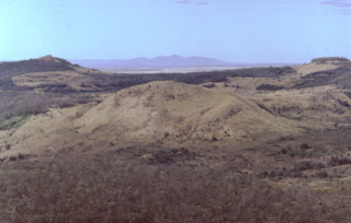 The rounded post-caldera lava dome in the center of the photo was constructed on the southern flank of Las Lajas volcano. In addition to flank domes, five coalescing domes were constructed within the caldera.
Photo by Benjamin van Wyk de Vries (Open University).
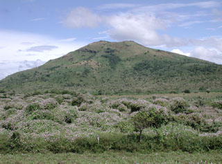
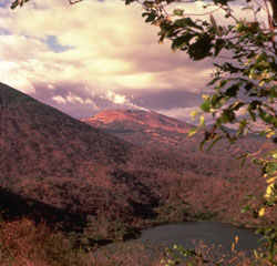
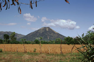
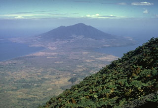
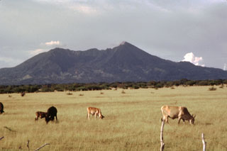 Volcán Mombacho rises above cattle ranches on the plain of Nandaime, south of the volcano. The volcano's irregular summit with two major peaks reaching 1222 and 1333 m resulted from collapse of the top of the volcano, which left the horseshoe-shaped depression in the center of the photo. Mombacho is the centerpiece of the Mombacho Volcano Reserve, whose forested terrain contains exotic orchids, birds and primates.
Photo by Jaime Incer, 1966.
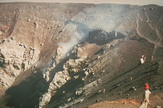
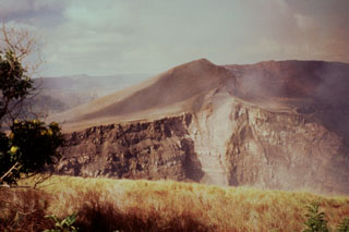 Santiago crater, seen here from the NE, formed in 1853. A strong detonation on April 9, 1853 was followed by heavy gas emission with no noticeable ejection of pyroclastic material. Flames were seen at the summit of the volcano on the night of September 15 from the town of Masatepe and later investigation revealed a new 80 x 65 m wide crater (later known as Santiago) with incandescent lava surrounded by volcanic bombs. Santiago pit crater expanded significantly in 1858-1859 and is now 600 m wide.
Photo by Jaime Incer, 1996.
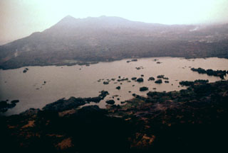
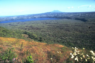 A broad expanse of lava flows extends across the floor of Nicaragua's Masaya caldera, with the wall forming the arcuate rim in the background. The lava flows originated from the post-caldera cones of Masaya and Nindirí. Lake Masaya is located against the eastern caldera wall. Recent lava flows have flooded much of the caldera and have overflowed its rim in one location on the NE side. This view from the NW shows Mombacho volcano in the distance.
Photo by Jaime Incer.
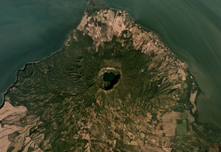
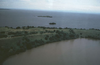 The low-rimmed Zapatera maar in the foreground is part of a maar complex at the NW tip of Zapatera Island on the western side of Lake Nicaragua. Remnants of other maars form small islets offshore. The surface of Lake Nicaragua, the country's largest body of water, lies only 30 m above sea level. The northern shore of the lake in the distance is about 35 km from Isla Zapatera. The long axis of the 70 x 160 km wide lake parallels the NW-SE trend of the Nicaraguan central depression.
 Photo by Jaime Incer, 1982.
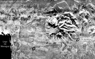
 The south slope of San Jacinto Viejo volcano is seen from the road between San Benito and Las Banderas. This subsidiary vent lies immediately SE of the rim of the large breached depression of San Jacinto.
Photo by Jaime Incer.
 The lake-filled Laguna de Asososca maar in the foreground and the Cerro Asososca cone to the right were formed by eruptions at the southern end of a N-S fissure system of the Las Pilas volcanic complex in Nicaragua. The ages of these vents are not known. This view looks from the NE across the broad plain at the foot of the Cordillera de los Maribios to the Pacific Ocean in the distance.
Photo by Jaime Incer, 1981.
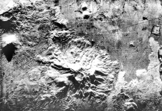 The deeply eroded Rota stratovolcano with its circular 1-km-wide summit crater lies at the bottom-center of this radar image. The latest eruption from the 832-m-high volcano produced thick andesitic lava flows NW of the summit, which extend nearly to the Malpaisillo road cutting diagonally across the image to the upper right. Two small NNW-SSE-trending lava domes (top-center), El Bosque, are located on the plain 2 km north of the flank of Rota (top-center). The Telica volcanic complex is visible at the upper left and lava flows from Las Pilas at the far right.
 Radar image, 1971 (courtesy of Jaime Incer).
 A thick ash column rises from Cerro Negro volcano in November 1968 in this aerial view from the south. A narrow, dark-colored lava flow issues from Cristo Rey, a vent at the SW base of the cone (lower left). The lighter-colored lava flow lobe below and to the right of the cone was erupted during 1960.
Photo by Tom Bretz, 1968 (courtesy of William Melson, Smithsonian Institution).
 Two dramatically different volcano morphologies are visible in this photo of Las Pilas volcanic complex. Conical 818-m-high Asososca stratovolcano (left foreground) has a pronounced erosional valley on its southern flank. Broad Las Pilas volcano (right background) rises to 1088 m and has a more complex volcanic history. These are the two most prominent of a roughly 30-km-long chain of N-S-trending vents.
Photo by Jaime Incer, 1995.
 The south side of Mombacho volcano is cut by a large horseshoe-shaped depression that left two major summit peaks. Recent landslips scar the face of the higher easternmost peak. The depression was formed during collapse of the volcano, which produced a large debris avalanche that traveled to the south. The 2-km-wide depression merges with a scarp from a NE-flank collapse, which lies on the other side of the notch in the center of the photo.
Photo by Jaime Incer, 1996.
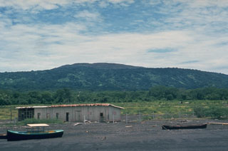
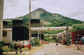 The Momotombo geothermal area, located near the shores of Lake Managua at the southern foot of the volcano, was identified and studied starting in the late 1960s. The first four wells were drilled in the early 1970s, culminating with the installation of a 35 MWe unit in 1983. Six years later, a second unit of 35 MWe went on line. After a period of declining output in the 1980s and 1990s due to overexploitation and lack of reinjection, the power output at Momotombo was restored to about 35 MWe by 2002.
Photo by Pat Dobson, 1996 (Lawrence Berkeley National Laboratory).
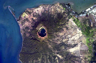
 The Cosigüina caldera, 2.5 km wide and more than 500 m deep, is in the center of this December 2019 Planet Labs satellite image monthly mosaic (N is at the top; this image is approximately 25 km across). The ridge SE of the caldera is the Loma San Juan lava flows, and the El Barranco Maar is NNE of the caldera. The arcuate ridge to the W is the Filete Cresta Montosa, interpreted as the remains of an older caldera.
Satellite image courtesy of Planet Labs Inc., 2019 (https://www.planet.com/).
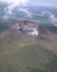
 A strong steam plume pours from the summit crater of San Cristóbal volcano in this March 1976 view from the NW. Mild explosive eruptions during March 9-16, 1976 were the first since 1971. In February 1972 part of the crater floor began subsiding, ultimately leading to formation of a collapse pit in March 1976. By December 1976 the pit had deepened to 90 m and incandescence was visible after dark.
Photo by Dick Stoiber, 1976 (Dartmouth College).
 Laguna de Madera occupies the roughly 800-m-wide summit crater of Maderas volcano. The summit and flanks of the volcano are offset along numerous faults. A N-S-trending leaf graben (a depression with opposing crescentic faults) cuts the west side of the summit of the heavily forested volcano. Displacements of 100 m or more occur on this and several other faults cutting the volcano.
Photo by Jaime Incer, 1990.
 Momotombo volcano, seen here from the east, is a prominent youthful stratovolcano constructed along the shores of Lake Managua. The peninsula in the foreground is Punta del Diablo, and the light-colored area at the left is the site of the Momotombo geothermal plant. The young volcano is only 4500 years old and has a long record of strombolian eruptions, with occasional larger explosive activity. In the distance are the conical peak of Cerro Asososca and the broad summit of Las Pilas volcano.
Photo by Jaime Incer, 1983.
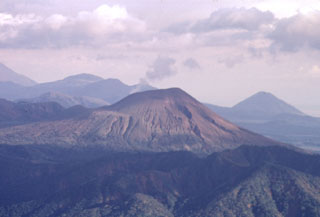
 An ash column rises in 1977 from the crater of Telica volcano, behind the ridge at the right. This was one of many explosive eruptions that took place between November 1976 and January 1978. The steep-sided symmetrical peak at the left is Santa Clara, one of several overlapping volcanoes of the Telica volcanic complex. Reports of historical eruptions from Santa Clara, located at the south end of the Telica complex, have not been substantiated. This view is from the SE.
Photo by Jaime Incer, 1977.
 The southern side of Las Pilas volcano is cut by a prominent transverse fissure, seen steaming in this 1970 view from the SW. A small circular pit crater, El Oyo, is located above the fissure just below the crater rim. Aside from a possible eruption in the 16th century, the only historical eruptions of Las Pilas took place in the 1950s from a fissure that extended across the east side of the 700-m-wide summit crater and down the north flank.
 Photo by Dick Stoiber, 1970 (Dartmouth College).
 Steam clouds fill much of the crater of San Cristóbal volcano in March 1976. After a quiescence of about five years, small ash eruptions took place at San Cristóbal on March 9-10, 1976, dropping ash on the nearby town of Chinandega. During an eruption on March 16 ash was confined primarily to the summit crater area. The summit crater of San Cristóbal is 500-600 m wide.
Photo by Dick Stoiber, 1976 (Dartmouth College).
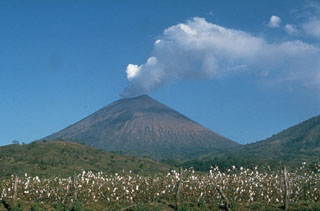
 Steam clouds blown to the west by trade winds pour from the summit crater of San Cristóbal in 1977 and blanket the volcano's flanks. The slopes of El Chonco, an eroded stratovolcano at the western end of the San Cristóbal complex, are seen at the right above cotton fields in the foreground. Several lava domes are found near the base of El Chonco, which also produced a 9-km-long lava flow that extends to within 1.5 km of the city of Chinandega, SW of the volcano.
Photo by Jaime Incer, 1977.
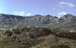
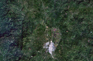 The area NW of the town of Estelí (bottom-center) and east of the prominent fault-bound valley at the left contains sparsely vegetated lava flows of the Estelí volcanic field. The flows were mostly erupted from fissure vents located in valleys in the northern interior highlands of Nicaragua between the town of Estelí and the border with Honduras.
 NASA Landsat 7 image (worldwind.arc.nasa.gov)
 The Apoyeque caldera to the left and the Xiloá Maar to the right are part of the Apoyeque volcanic complex shown in this December 2019 Planet Labs satellite image monthly mosaic (N is at the top; this image is approximately 27 km across). Apoyeque is one of 11 features within the Chiltepe Volcanic Complex at the northern end of the Nejapa Volcanic Field. The ridge to the ENE of the caldera is composed of cones, domes, and lava flows, and Cerro Talpetate is south of the maar.
Satellite image courtesy of Planet Labs Inc., 2019 (https://www.planet.com/).
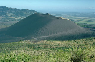
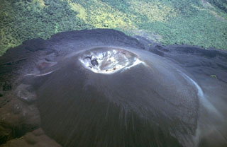 Cerro Negro, Central America's youngest volcano, is a pyroclastic cone that began growing in 1850. It is seen here 130 years later in an aerial view from the NW. The cone rises about 250 m above its base and is surrounded by lava flows that bank up against and are deflected by the slopes of Las Pilas volcano at the top of the photo. More than 20 eruptions, separated by quiet intervals of a few years to a few decades, have taken place in the past century and a half at this small-volume basaltic volcano.
 Photo by Jaime Incer, 1980.
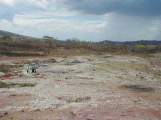 Mudpots and fumaroles mark the San Jacinto - Tizate geothermal area on the NE side of the Telica volcanic complex, the first geothermal power facility in Nicaragua to be fully developed by the private sector. Feasibility studies suggest possible power generation of 173-240 MW. Inauguration and reliability testing of the first 10 MW of power generation began in June 2005.
Photo by Eliecer Duarte, 2002 (OVSICORI-UNA).
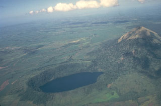
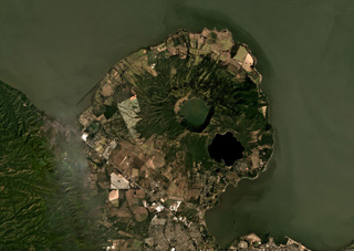
 The circular Apoyo caldera is filled by beautiful Laguna de Apoyo. The NE caldera wall in the background rises about 120 m above the surface of the lake, which is only 78 m above sea level. The only road access to the lake is along its western shore. The caldera was formed by collapse along near-vertical faults following two major dacitic explosive eruptions about 23,000 years ago from a vent area inferred to be near the NE part of the caldera.
 Photo by Jaime Incer.
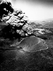
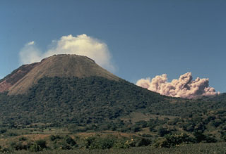
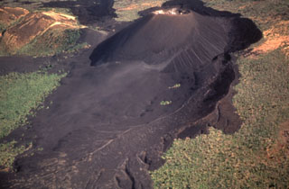
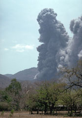 An ash-rich eruption plume rises above Cerro Negro volcano in April 1992. Violent strombolian eruptions during 9-14 April produced heavy ashfall that caused extensive damage to buildings and croplands and forced the evacuation of 28,000 people. Ash clouds reached heights of 7-7.5 km and were distributed to several hundred km distance. The strong explosive eruption enlarged the summit crater to 370 m width.
Photo by Chuck Connor, 1992 (Southwest Research Institute).
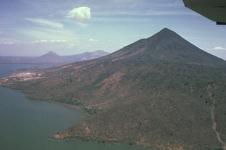
 The summit of Cosigüina volcano, seen here from the west with the Gulf of Fonseca in the background and the border with Honduras at the upper left, contains a 2 x 2.4 km wide caldera with steep-sided, 500-m-high walls. The upper flanks of the volcano are only partially forested after a devastating eruption in 1835 produced pyroclastic flows and surges that reached the coast and fountain-fed lava flows that blanketed the upper eastern and western flanks. The peak in the distance below the right side of the wing is San Cristóbal volcano.
Photo by Jaime Incer, 1981.
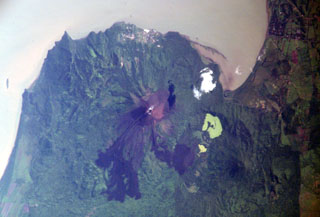
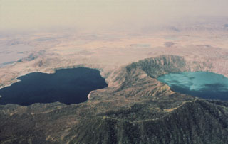 The deep blue Laguna de Jiloa (left) and the turquoise-colored Laguna Apoyeque dramatically fill two calderas on the Chiltepe Peninsula north of Managua. The 2.8-km-wide Apoyeque caldera, the source of the major Chiltepe Pumice about 2000 years ago, has a more circular outline than the scalloped 2.5 x 3 km wide Jiloa caldera, which was the site of a major explosive eruption about 6500 years ago.
Photo by Jaime Incer, 1980.
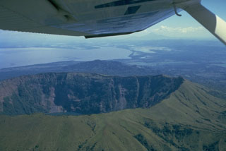
 Las Lajas is the largest Quaternary volcano east of the Nicaraguan graben. The broad edifice contains a 7-km-wide, 650-m-deep caldera, with the SSW rim forming the horizon here. In the foreground are part of a group of five lava domes that are located in the center of the caldera. Additional domes are on the outer flanks.
 Photo by Benjamin van Wyk de Vries (Open University).
 The profile of Cosigüina is not particularly impressive when viewed from its NE flank along the coast of the Gulf of Fonseca near the town of Potosí. The broad low-angle slopes of Cosigüina rise only 872 m above the coast and give little hint of the dramatic caldera that cuts the summit. Pyroclastic flows from the 1835 eruption reached the northern coast of the 20-km-wide Cosigüina Peninsula and formed new ephemeral islands in the Gulf of Fonseca.
Photo by Dick Stoiber, 1978 (Dartmouth College).
 The steep-walled, lake-filled summit caldera of Cosigüina volcano is prominent in this NASA International Space Station image with north to the upper left. Bahia el Rosario lies to the right of the elongate peninsula at the upper left with Punta San Jose at its tip, and the town of Potosi is at the top center. The scarp of an older caldera rim forms Filete Cresta Montosa, the semi-arcuate ridge below the summit caldera. This scarp continues in a more subdued form to the northern side of the volcano.
NASA International Space Station image ISS006-E-51438, 2003 (http://eol.jsc.nasa.gov/).
 Las Pilas volcanic complex includes a cluster of cones, of which Las Pilas (El Hoyo), in the center background, is the largest. A N-S fracture system cutting across the cone has produced numerous well-preserved flank vents, including maars. Cerro Asososca is the prominent conical volcano in the right foreground of this photo from the SW. Cerro Grande is the peak at the upper left. The only certain historical eruptions of Las Pilas took place in the 1950s from a fissure that cut across the summit east of the 700-m-wide summit crater.
 Photo by Jaime Incer, 1981
 Las Pilas volcano (center), with a steam plume pouring from a vigorous fumarole on the SE side of the summit, is viewed here from the south rim of Laguna de Asososca, a 1.3 x 2 km wide maar on the southern end of Las Pilas volcanic complex. The surface of Laguna de Asososca is less than 100 m above sea level. At the left is the eastern flank of Cerro Asososca stratovolcano.
 Photo by Jaime Incer, 1982.
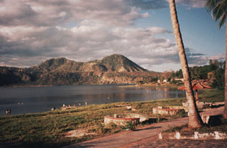 The SE shore of Laguna de Jiloa is the site of tourist resorts that are popular destinations from the nearby capital city of Managua. The Chiltepe Hills on the horizon beyond the caldera rim to the north are the high points of the Chiltepe Peninsula.
Photo by Jaime Incer, 1996.
 The 7-km-wide, lake-filled Apoyo caldera, seen here from the NW with Mombacho volcano in the background, is a large silicic volcanic center immediately SE of Masaya caldera. An early shield volcano constructed of basaltic-to-andesitic lava flows and small rhyodacitic lava domes collapsed following two major dacitic explosive eruptions about 23,000 years ago. Post-caldera ring-fracture eruptions formed the Granada cinder cones and La Joya collapse craters along fracture systems to the east of the caldera. The age of the latest activity is not known.
Photo by Alain Creusot-Eon, courtesy of Jaime Incer, 1968.
 Cerro Negro, the unvegetated cinder cone at the left center, was born on April 13, 1850 on an uninhabited plain between Las Pilas (in the background) and Rota volcanoes. The new cone reached a height of 50-60 m in ten days, after which activity subsided until renewing on May 27. The tephra-mantled lava flow in the middle of the photo, extending from the western base of the cone to the forest in the foreground, was erupted in 1850. The Las Pilas volcanic complex includes the peaks of Cerro Grande, Las Pilas itself, and Cerro Ojo de Agua.
Photo by Willard Parsons, 1971 (courtesy of Bill Rose, Michigan Technological University).
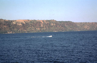
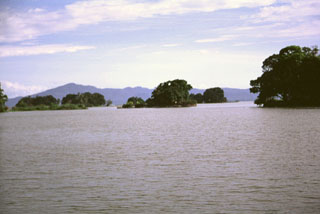
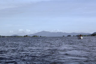 A small boat plies the waters of Ensenada de Aseses, with Zapatera Island forming the horizon to the SE. In the middle distance are the small island hummocks of Las Isletas, formed by a debris avalanche from Mombacho volcano, out of view to the right. The conical peak on the distant left horizon is Concepción volcano; the low, rounded peak to its left is Cerro las Banderas, a pyroclastic cone on the NE tip of Zapatera Island.
Photo by Paul Kimberly, 1998 (Smithsonian Institution).
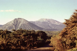
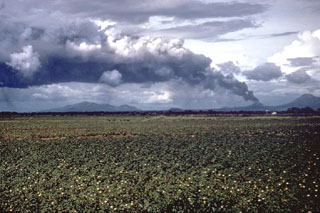
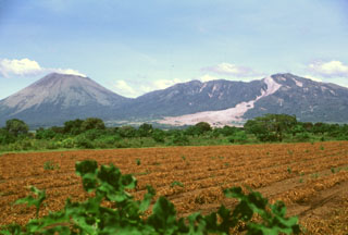 This tranquil scene of steaming San Cristóbal volcano (left) and elongated Casita volcano (right) rising above fields in the León plain is marred by the fresh three-week-old scar of an avalanche and mudflow from Casita. Torrential rainfall accompanying Hurricane Mitch in October 1998 contributed to the collapse near the summit of Casita, which inundated the towns of El Porvenir and Rolando Rodriguez as well as other settlements.
Photo by Lee Siebert, 1998 (Smithsonian Institution).
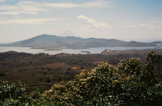 Zapatera Island, seen here from the NW on the lower flanks of Mombacho volcano, is a small low shield volcano that forms a 7 x 10 km wide island in Lake Nicaragua. The small roughly circular 2-km-wide El Llano caldera is located near the center of the island. Numerous low-rimmed tuff rings and maars are found on the northern and western sides of the densely forested 629-m-high island and across a narrow strait on the adjacent mainland. Concepción is the conical volcano in the distance beyond Zapatera.
Photo by Jaime Incer, 1995.
 The N-S-trending Nejapa-Miraflores alignment of cones cuts across the western outskirts of the city of Managua and extends across a bay of Lake Managua onto the Chiltepe Peninsula. Cerro San Carlos (center) lies along the southern side of the bay, while the conical peak of Volcán Chiltepe is visible at the upper left on the eastern tip of the Chiltepe Peninsula.
Photo by Paul Kimberly, 1998 (Smithsonian Institution).
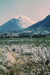
 A large tephra cloud silhouetted against weather clouds rises from Cerro Negro volcano in November 1968. Strong winds blowing from the east deflect the ash plume. This view from the SW looks across cotton fields of the Nicaraguan central depression to the Marrabios Range volcanoes. To the right of Cerro Negro is Las Pilas volcano, and the broad massif to the left is Rota volcano.
Photo by Dick Stoiber, 1968 (Dartmouth College).
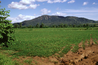 The low, forested Rota stratovolcano rises above fields to its west in the area between Cerro Negro volcano and the Telica volcanic complex. A 1-km-wide circular crater whose rim is lowest on the southern side lies at the summit. The latest eruption from Rota produced thick andesitic lava flows from a NE-trending fissure NW of the summit. No historical eruptions are known from Volcán Rota, although seismic swarms occurred in 1986, 1989, and 1992.
 Photo by Lee Siebert, 1998 (Smithsonian Institution).
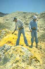 The summit crater of Momotombo is covered with areas of extensive hydrothermal alteration, including this area of sulfur deposition. Temperatures of 465-780° C were measured in summit crater fumaroles at the time of this visit in June 1980. Intense fumarolic activity occurs at the summit crater. The summit crater fumaroles remained very hot in late 1980 with temperatures measured up to 735°C and reported to > 900°C. Portions of the crater were seen to glow red and orange when observed at night.
Photo by Mike Carr, 1980 (Rutgers University).
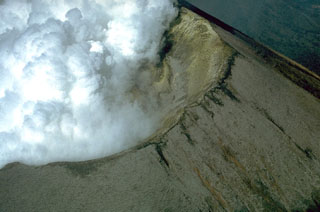
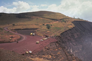
 An aerial view from the SW after the 1992 eruption shows the greatly enlarged summit crater. The 1992 eruption expanded the summit crater to 370 m in diameter and an average depth of 90 m. Heavy ashfall caused extensive damage to buildings and croplands. No lava flows were erupted. The lobate lava flow extending to the bottom of the photo was erupted in 1968, and the tephra-mantled flow to its left was emplaced in 1960.
Photo by Jaime Incer, 1992.
 Telica, one of Nicaragua's most active volcanoes, has erupted frequently since the time of the Spanish conquest. The Telica volcano group consists of several interlocking cones and vents with a general NW alignment. Telica itself, seen here in an aerial view from the NE, is a steep-sided cone with a 700-m-wide double crater. The steaming NE crater, the source of recent eruptions, is 120 m deep. The rim of an older crater of the Telica complex forms the ridge at the lower left.
 Photo by Robert Citron, 1968 (Smithsonian Institution).
 Conical Santa Clara volcano lies at the SE end of the Telica volcanic complex. The 834-m-high stratovolcano, seen here from the south, has a small summit crater about 150 m in diameter. Santa Clara was considered to have been active during the 16th century, and early explorers reported the volcano to be smoking, but no specifically dated eruptions have been recorded.
Photo by Paul Kimberly, 1998 (Smithsonian Institution).
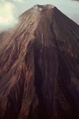
 The San Cristóbal volcanic complex consists of five principal edifices. The youngest cone, the namesake San Cristóbal, seen here from the south, is the highest peak of the Marrabios Range. Several radial flank craters occur along a N-S line on the outer north flank of 1745-m-high San Cristóbal. Historical activity, consisting of small-to-moderate explosive eruptions, has been reported since the 16th century. The SW crater rim (left) rises 140 m above the NE rim because prevailing trade winds distribute tephra to the SW.
Photo by Jaime Incer.
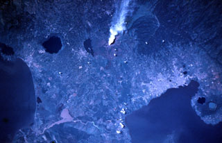 A vigorous steam plume pours from Masaya volcano in this November 9, 1984 Space Shuttle image taken near the end of a two-decade-long eruptive episode. North lies to the lower right, with Lake Nicaragua at the lower left and Lake Managua at the lower right. To the left of the plume from Santiago crater is Lake Masaya (ponded against the rim of Masaya caldera) and the circular lake-filled Apoyo caldera. The two caldera lakes at the lower right are Apoyeque (light blue) and Jiloa (dark-colored), across the bay from the city of Managua.
NASA Space Shuttle image STS51A-32-64, 1984 (http://eol.jsc.nasa.gov/).
 Masaya Volcano National Park provides visitors with the opportunity to observe activity at a frequently active volcano. This observation point on the NE side of Santiago crater is easily accessible from the capital city of Managua. The hazards of close access were underscored in April 2001, when a sudden explosion without precursors ejected blocks onto the parking lot and the surrounding area during a visit by cruise ship passengers. Fortunately, only minor injuries occurred.
Photo by Jaime Incer.
 Cerro San Jacinto, a stratovolcano constructed along the eastern margin of the Nicaraguan central graben east of Lake Managua (lower left), is seen at the center of this radar image. A large central depression at San Jacinto (also known as San Jacinto Viejo) is widely breached to the west. Lava flows and pyroclastic beds within the walls of the depression dip away from its center. The towns of San Benito and Las Banderas are circled.
 Radar image, 1971 (courtesy of Jaime Incer).
 Masaya is one of Nicaragua's most unusual and most active volcanoes. It is a broad, 6 x 11 km basaltic caldera with steep-sided walls up to 300-m high. The caldera is filled on its NW end by more than a dozen vents erupted along a circular, 4-km-diameter fracture system. The twin volcanoes of Nindirí and Masaya are seen here from the east caldera rim above Lake Masaya. Masaya has been frequently active since the time of the Spanish Conquistadors, when an active lava lake prompted several attempts to extract the volcano's molten "gold."
 Photo by Jaime Incer.
 Telica volcano is seen here in a telephoto view looking down the Marrabios Range from near the summit of Casita volcano. A thin steam plume rises from a fumarole in the summit crater. Behind Telica on the left horizon is Las Pilas volcano, and the conical peak at the extreme right is Cerro Asososca, at the south end of the Las Pilas complex.
Photo by Paul Kimberly, 1998 (Smithsonian Institution).
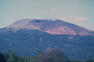
 Oxidized, reddish-colored rocks form much of the summit cone of Momotombo volcano, seen here from the NW towering more than a kilometer above one of several small ponds on the floor of Monte Galán caldera. The 4-km-wide caldera was the source of a major ignimbrite about 50,000 years ago.
Photo by Jaime Incer.
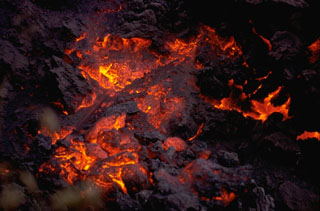 Incandescent lava is visible on the cooling surface of an advancing lava flow from Cerro Negro volcano in 1968. The flow front, which advanced at a rate of about 5 m/hr during the first day of the eruption. The flow originated from a horseshoe-shaped flank vent south of Cerro Negro.
Photo by William Melson, 1968 (Smithsonian Institution).
 A geologist surveys the enlarged crater of Cerro Negro volcano in December 1972, observing the effects of the previous eruption during February 3-14, 1971. Powerful explosions substantially enlarged the summit crater from 150 m in diameter before the eruption to 400 m after it. This highly explosive eruption produced ashfall that caused extensive crop damage over a 5000 km2 area.
Photo by Dennis Nielson, 1972 (courtesy of Mike Carr, Rutgers University).
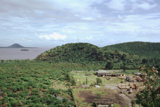
 Mombacho volcano in the background collapsed during the late Pleistocene, producing a debris avalanche that swept into Lake Nicaragua, deposting debris that accumulated to form the Aseses Peninsula in the foreground. The surface of the avalanche deposit lies below the lake surface immediately offshore of the mainland, creating the Bay of Aseses in the middle of the photo. Portions of the deposit rise above the lake surface, forming hundreds of small islands.
Photo by Jaime Incer.
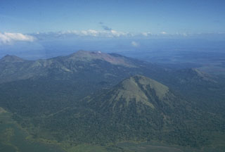
 This low-angle aerial view from the south shows the profile of the Telica volcanic complex, which consists of several interlocking cones and vents with a general NW alignment. Telica itself, the high peak at the left, is a steep-sided cone with a 700-m-wide double crater. El Liston, immediately E of Telica (at center), has several nested craters. Santa Clara volcano is the symmetrical cone at the right.
Photo by Dick Stoiber, 1972 (Dartmouth College).
 These small forested islands are hummocks of a large debris avalanche from Mombacho volcano that swept into Lake Nicaragua. The horizon is formed by Isla Zapatera volcano, SE of Mombacho.
Photo by Lee Siebert, 1998 (Smithsonian Institution).
 Volcán Maderas is a symmetrical, 1394-m-high stratovolcano that forms the SE end of the dumbbell-shaped Ometepe island in Lake Nicaragua. It is seen here from the upper slopes of Concepción volcano, to which it is connected by a narrow isthmus. Maderas is cut by numerous faults and small grabens. Many pyroclastic cones are situated on the lower NE flank down at the level of Lake Nicaragua. The latest period of major growth of the volcano took place more than 3000 years ago.
Photo by Alain Creuset-Eon, 1972 (courtesy of Jaime Incer).
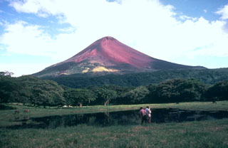
 More than 40 individual lava flows are visible on Concepción's flanks and frequent eruptions have substantially modified the summit region. Much of the upper cone, including the south side flank here, remains unvegetated and has undergone extensive erosion
Photo by Jaime Incer, 1994.
 Cerro Negro volcano is viewed here on December 6, 1995, from the SE on the flanks of Las Pilas volcano. The photo was taken on the final day of an eruption that began on May 28 or 29. Minor ash eruptions had continued intermittently until August 16 and resumed November 19 until December 6. The eruption was accompanied by growth of a small lava dome in the summit crater and lava flows that traveled down the north flank
Photo by Britt Hill, 1995 (Southwest Research Institute).
 Fresh-looking, dark-colored lava flows from the 1905 eruption of Momotombo volcano are prominent in this NASA International Space Station image with north to the top. The NW-most flow cascaded into Monte Galán caldera, with the greenish Laguna Monte Galán near its southern rim. Laguna Las Piedras lies near the center of the caldera, near the toe of the NW lava flow. The light-colored developed area south of the summit along the shore of Lake Managua is the Momotombo geothermal field.
NASA International Space Station image ISS005-E-16247, 2002 (http://eol.jsc.nasa.gov/).
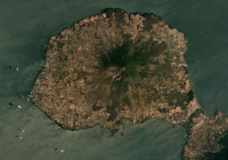 The steep Volcán Concepción forms the center of the northeastern portion of Ometepe Island in Lake Nicaragua, shown in this March 2019 Planet Labs satellite image monthly mosaic (N is at the top; this image is approximately 24 km across). Deformation occurs due to the volcano forming on top of unstable lake sediments of mud and clay. Spatter cones, cinder cones, lava domes, and maars have formed across the flanks. Maderas volcano forms the SE side of the island, out of view here.
Satellite image courtesy of Planet Labs Inc., 2019 (https://www.planet.com/).
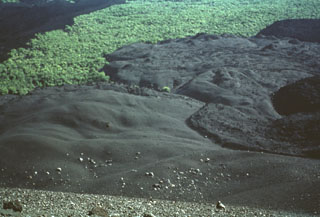 The lava flow at the right, partially mantled by tephra, was erupted in July 1947. A strong explosive eruption produced ashfall that damaged crops at Malpaisillo. The 1947 lava flow originated from a parasitic cone and traveled to the NE. This photo from the northern side of Cerro Negro also shows darker-colored lava flows from the 1957 eruption at the extreme right and at the upper left.
Photo by Bill Rose, 1971 (Michigan Technological University).
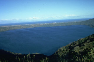 The 7-km-wide, lake-filled Apoyo caldera is seen here from the W with Lake Nicaragua in the distance beyond its low eastern caldera rim. The surface of Laguna de Apoyo is 78 m above sea level. The steep caldera walls rise about 100 m along the eastern rim and up to 500 m along the western rim (foreground). The caldera was formed during two major dacitic explosive eruptions radiocarbon dated at about 23,000 years BP.
Photo by Jaime Incer.
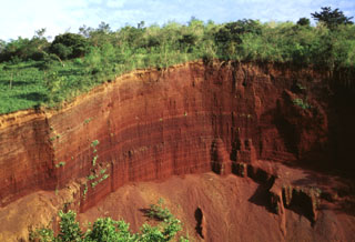 A quarry exposes bedded oxidized scoria layers in a cinder cone of the fissure-fed Granada alignment. The cone was constructed along a semi-arcuate, N-S-trending fracture located between the city of Granada and the northern flanks of Mombacho volcano, east of the rim of Apoyo caldera. The lineament is also known as the La Joya alignment, after the explosion craters located SW of Granada. The alignment originated about 12,000 years ago, and its latest eruptions may have occurred as recently as about 2000 years ago.
Photo by Lee Siebert, 1998 (Smithsonian Institution).
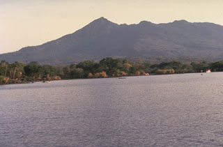 Mombacho is a stratovolcano on the shores of Lake Nicaragua that has undergone edifice collapse on several occasions. The NE-flank scarp was the source of a large debris avalanche that produced an arcuate peninsula and the Las Isletas chain of islands in Lake Nicaragua. The only reported historical activity was in 1570, when a debris avalanche destroyed a village on the S side of the volcano.
Photo by Jaime Incer, 1977.
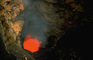 An incandescent vent glows on the floor of Santiago crater in July 1972. A new lava lake formed in Santiago crater in October 1965. By 1969 activity was restricted to a small spatter cone; after it collapsed in 1972 a lava lake was visible until 1979. Periodic lava lake activity has occurred since the time of the Spanish Conquistadors. The partially yellow incandescence of the active lava lake was taken for molten gold, prompting several attempts to mine it.
Photo by Dick Stoiber, 1972 (Dartmouth College).
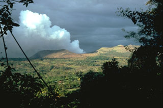 Masaya volcano is noted for long-duration periods of voluminous gas emission. This February 1982 photo from the NE shows a gas plume pouring from Santiago crater, during the 4th gas emission crisis of the 20th century. Emission of a very large gas plume had continued without interruption since the fall of 1979. Remote sensing of SO2 revealed continued high level flux, with a 1500-2000 tons/day average during 1980. Distribution of the gas plumes by prevailing winds caused widespread crop damage.
Photo by Dick Stoiber, 1982 (Dartmouth College).
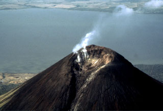 Fumaroles in the summit crater of Momotombo volcano emit vigorous vapor plumes. The 150 x 250 m wide crater of Momotombo is narrowly breached to the NE, where a lava flow emerged during the 1905 eruption. The geothermal field on the southern flank of Momotombo can be seen at the lower left along the shores of Lake Managua.
Photo by Jaime Incer, 1991.
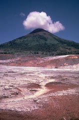 Hydrothermally altered ground in the foreground is part of 2 km2 geothermal field on the southern flank of Momotombo volcano. The Patricio Arguello Ryan geothermal plant at one point produced 25% of the electrical power of Nicaragua. Summit crater fumarolic activity increased following development of the geothermal field.
Photo by Jaime Incer.
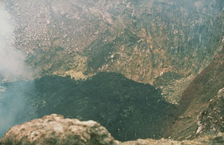 Fresh black lava fills the floor of Santiago crater in December 1976. A new lava lake appeared on the floor of Santiago Crater on October 20, 1965, marking the beginning of Masaya's third 20th-century lava lake cycle. Several lava flows occurred on the crater floor between 1965 and 1972. The spatter cone collapsed in 1972 and lava lake activity was visible until 1979, when the lava lake subsided, producing thick gas emissions.
 Photo by Dick Stoiber, 1976 (Dartmouth College).
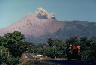 A small ash cloud from an eruption in 1977 rises from the crater of Telica volcano as seen from the outskirts of the city of León. Intermittent explosions began in November 1976, and continued at a rate of one sizeable explosion a month until November 1977, when activity increased. On November 11 ashfall reached the Pacific Ocean. The eruption continued into January 1978.
Photo by Jaime Incer, 1977.
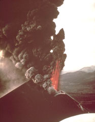 An incandescent lava fountain and a thick ash-laden eruption column rise above the summit crater of Cerro Negro volcano in 1968. Ash columns were distributed primarily to the west, and intense ashfall affected the León-Chinandega area, one of the most densely populated and important agricultural areas in Nicaragua. This aerial view from the SE shows the Telica and San Cristóbal volcanic complexes in the far right distance.
 Photo by William Melson, 1968 (Smithsonian Institution).
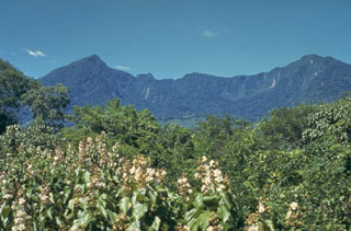 The south side of Mombacho contains a horseshoe-shaped crater that was the source of a large debris avalanche in 1570 CE that swept over a village south of the volcano, killing 400 people. The avalanche traveled 13 km S; contemporary accounts note that if it had occurred to the north, it would have reached the city of Granada. Contemporary accounts indicate that the volcano "exploded," but eruptive activity associated with the collapse has not been documented.
Photo by Jaime Incer.
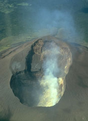 This photo taken on July 1987 looks into the double summit crater of Telica volcano in Nicaragua. An older shallower crater is located on the SW side (top). A plume rises from fumaroles in the 120-m-deep NE crater (bottom), which is the source of recent eruptions.
 Photo by William Melson, 1987 (Smithsonian Institution).
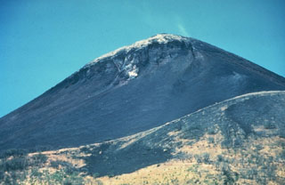 Light-colored fumarolic sublimates drape the 1297-m-high summit of Momotombo volcano, which displays strong fumarolic activity. Fumarolic temperatures (850 degrees C) and seismicity at the volcano increased following construction of the Momotombo geothermal plant.
Photo by Jaime Incer.
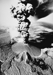 This dramatic photo of Cerro Negro in eruption in November 1968 shows a vigorous vertical ash plume rising from the summit crater. This view from the east also shows the smoking flank vent of Cristo Rey at the southern base of the cone. This vent fed a lava flow that traveled 1.5 km to the SW. Fresh lava flows in the left foreground were erupted in 1960, and those from the prominent east-flank vent (lower center) were erupted in 1957.
Photo by Tom Bretz, 1968 (courtesy of William Melson, Smithsonian Institution).
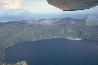 Apoyeque stratovolcano forms the large Chiltepe Peninsula in central Lake Managua. A 2.8-km wide, 500-m-deep caldera truncates the volcano's summit, below and to the left of the airplane wing. Laguna de Jiloa, the large lake in the foreground, lies immediately SE of Apoyeque. The age of the latest eruption of Apoyeque is not known, but human footprints underlie pumice deposits thought to originate from Apoyeque volcano or a nearby vent beneath Lake Managua. Momotombo volcano is visible in the distance to the NW across Lake Managua.
 Photo by Jaime Incer, 1981.
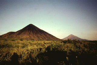 Two conical peaks of differing age rise to the east above the floor of the Nicaraguan depression. Cerro Asososca (left), part of Las Pilas volcanic complex, was constructed along a fissure extending south from Las Pilas. Erosional gullies cut the flanks of the 818-m-high cone. In the distance to the right is the younger Momotombo volcano, frequently active during historical time.
Photo by Jaime Incer, 1996.
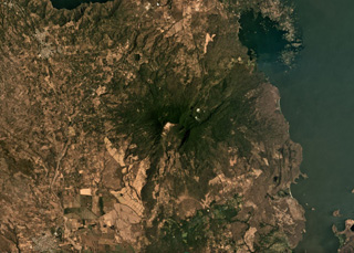 Two major flank-collapse scarps on the NE and SW sides of Mombacho are visible in this March 2019 Planet Labs satellite image monthly mosaic (N is at the top; this image is approximately 25 km across). The islands to the NE are part of the 56.8 km2 Las Isletas debris avalanche deposit; the 49.5 km2 El Crater debris avalanche deposit is to the S. The La Danta debris avalanche deposit is between the two on the SE flank and surrounding area.
Satellite image courtesy of Planet Labs Inc., 2019 (https://www.planet.com/).
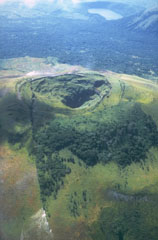 The 1-km-long fissure that reaches from the lower left across the summit crater of Las Pilas was formed during an eruption in 1952. The eruption, which began on October 23, produced ash-bearing steam clouds that ejected fragments of rock from the walls of the new fissure. The eruption ended in December. This view from the north shows the undated Laguna de Asososca maar (upper right), which was formed near the southern end of the fissure system cutting across Las Pilas volcanic complex.
Photo by Jaime Incer, 1981.
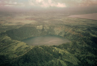 Laguna de Apoyeque fills a 2.8-km-wide caldera constructed at the center of the Chiltepe Peninsula. The caldera rim rises about 400 m above the lake, whose surface lies only about 40 m above sea level. Two major pumice deposits erupted about 18,000-25,000 years ago originated from Apoyeque caldera. The Lower Apoyeque pumice was erupted about 22,000-25,000 years ago, while the Upper Apoyeque pumice, which forms a distinctive layer in the Managua area, was erupted a few thousand years later. Lake Managua lies at the upper right.
Photo by Jaime Incer, 1996.
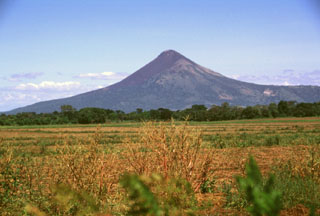 Momotombo volcano towers above the floor of the Nicaraguan depression. Following its birth about 4500 years ago, a catastrophic eruption of Old Momotombo volcano about 2700-2800 years ago produced large amounts of tephra and pyroclastic flows. As a result of this eruption a 1.5 x 1.1 km wide crater was formed at the summit. Subsequent eruptions beginning about 800-900 years ago created the Young Momotombo volcano, which filled much of this crater and forms the present summit.
Photo by Lee Siebert, 1998 (Smithsonian Institution).
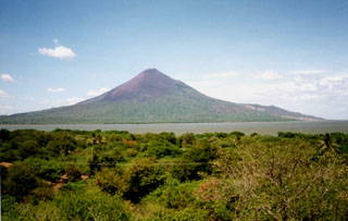 Momotombo volcano, seen here from the west near Puerto Momotombo, towers about 1250 m above Lake Managua. The volcano was constructed beginning about 4500 years ago SE of Monte Galán caldera, which lies out of view to the left. Geothermal exploration has occurred on its southern flank (the light-colored area at the right).
Photo by Pat Dobson, 1998 (Lawrence Berkeley National Laboratory).
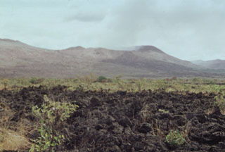 The blocky lava flow in the foreground was erupted in 1772 from a vent on the northern side of Old Masaya cone (extreme left). The dark flow at the upper right spilling over the rim of Nindirí crater was erupted in 1670 and traveled down the northern flank of the cone.
Photo by Paul Kimberly, 1998 (Smithsonian Institution).
 Volcanologist Bill Rose measures a large bomb ejected during the 1971 eruption of Cerro Negro volcano. The bomb landed on the flank of the cinder cone and rolled across the surface of fresh ash. The 1971 eruption took place February 3-14. Heavy ashfall produced extensive crop damage. This photo was taken in March 1971.
Photo by Dick Stoiber, 1971 (Dartmouth College).
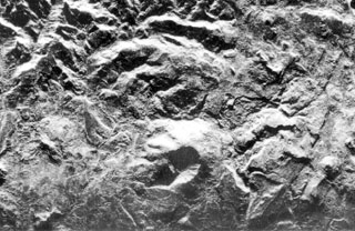 The stratovolcano at the lower center of this radar image is Cerro el Ciguatepe, one of several Quaternary volcanoes that lie in the Nicaraguan interior highlands. A well-preserved 1.5-km-wide crater is breached to the SW and partially filled by a blocky plug dome. The steep-sided stratovolcano was constructed at the boundary of flat-lying Tertiary ignimbrite deposits and fault-blocks bordering the Nicaraguan depression.
 Radar image, 1971 (courtesy of Jaime Incer).
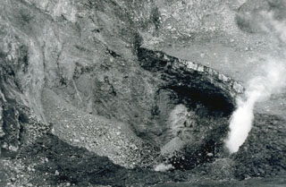 A small eruption occurred from Santiago crater on February 15, 1987 following blockage of the vent by landslides in November and December 1986. The small eruption ejected ash and blocks, which fell back into the bottom of the vent. Additional collapses took place on February 20, and the circular vent continued to produce small eruptions after February 22. This photograph of Santiago's inner crater (180 m in diameter and 72 m deep) was taken after the collapse events of late 1986 and early 1987.
 Photo by Douglas Farjado, 1987 (INETER).
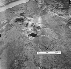 An aerial oblique photo from the NW shows the summit crater complex of Masaya volcano. The wall of the 6 x 11 km wide caldera inside which the central cone complex was constructed can be seen at the upper right and the extreme upper left (where it contains Lake Masaya).
Aerial photo by Instituto Geográfico Nacional, 1975 (courtesy of Jaime Incer).
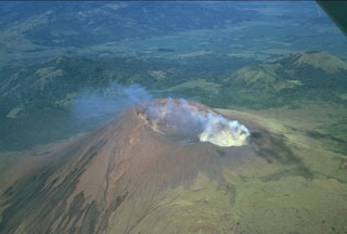 A prominent fumarole on the NE rim of the summit crater of Telica volcano produces a diffuse plume in this 1981 view. The double summit crater is viewed from the SE with the grassy cone of Cerro de Aguero, the northernmost cone of the Telica volcanic complex, at the upper right. The flanks of La Pelona caldera, part of the neighboring San Cristóbal volcanic complex, can be seen at the top of the photo across a low saddle.
Photo by Jaime Incer, 1981.
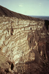 Santiago crater was initially formed in 1853, but the present pit crater formed during the 1858-1859 eruption. A column of flames and ash eruptions were reported on January 27 and March 27, 1859 accompanied by collapse of Santiago and San Pedro Craters. After its initial collapse, Santiago pit crater was a vertical cylinder about 150 m deep and 600 m across. By the time of the 1865 visit of Seebach, the craters had evolved to their present configuration.
 Photo by Jaime Incer, 1992.
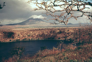 Laguna de Asososca in the foreground is a maar that was constructed along a fissure extending south from Las Pilas volcano. The maar is elongated N-S in the direction of the fissure system and is about 2 km long in that direction. Prevailing winds to the west constructed a higher rim on that side, the vantage point of this photo. The cloud-capped conical peak in the distance is Momotombo, and the much lower peak to its right is Momotombito, which forms an island in Lake Managua.
Photo by Jaime Incer.
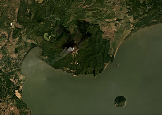 Momotombo rises above the NW shore of Lake Managua and is in the center of this December 2019 Planet Labs satellite image monthly mosaic (N is at the top; this image is approximately 22 km across). Gas emissions emanating from the summit crater are dispersing to the SW. Lava has flowed into Monte Galán caldera on the NW flank towards Cerro Motoso, a cone on the NW caldera rim. The island to the SE is Volcán Momotombito and is part of the Momotombo complex. Lava flows in 2015 were emplaced down the NE flank on top of 1905 flows.
Satellite image courtesy of Planet Labs Inc., 2019 (https://www.planet.com/).
 Street lights burn during daytime as heavy ashfall turns afternoon into night on the streets of León (18 km WSW of Cerro Negro) during an April 1992 eruption. Violent strombolian eruptions during 9-14 April produced heavy ashfall, damaging croplands and forcing the evacuation of 28,000 people. On the evening of 10 April, 15 houses and other structures, including large storage buildings, collapsed in and near León. Collapses of numerous farm buildings, rural homes, and school buildings were reported over the next several days.
 Photo by Jaime Incer, 1992.
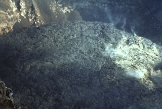 An October 1971 photo from the crater rim shows a fresh black lava flow extruded onto the crater floor. Fumaroles rise from the surface of the flow at the right. Masaya began a long-duration eruptive period in 1965. Several lava flows, such as this one, were erupted between 1965 and 1972. An active lava lake was visible until 1979, and intermittent small explosive eruptions lasted until 1985.
Photo by Bill Rose, 1971 (Michigan Technological University).
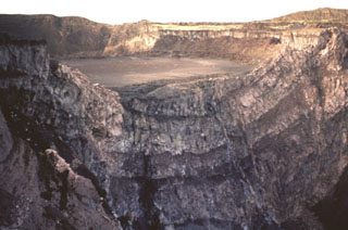 Nindirí crater is partially truncated by the walls of Santiago crater, which formed in 1858-1859. The crater walls reveal flows from lava lakes erupted between 1524 and 1670. An active lava lake was apparently present in Nindirí crater from 1524 to 1544, as reported by Spanish Friars passing through Nicaragua. The Spanish chronicler Oviedo observed the lava lake when he climbed the volcano in July 1529. In 1534 Friar Bartolomé de las Casas reported that a letter could be read at night in the town of Nindirí (6 km away) by the glow of lava.
 Photo by Jaime Incer, 1991.
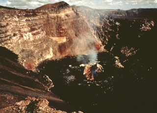 Fume rises in 1978 from a vent on the floor of Santiago crater, seen here from its SE rim. The floor of the crater is covered by fresh lava flows erupted between 1965 and 1972. A lava lake was present on the part of the crater floor until 1979, and intermittent explosive activity continued until 1985.
Photo by Jaime Incer, 1978.
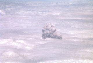 A convecting ash-bearing eruption cloud from Telica volcano punches through a low cloud layer in February 1982. Continuous white vapor columns with occasional ash were observed beginning in late November 1982, and small gas-and-ash eruptions took place in late December and early January. Large eruptions on February 12 and 19 sent clouds to 3.7-4.3 and 3.5 km above sea level, respectively. Eruptive activity ended on March 2.
Photo by Bill Rose, 1982 (Michigan Technological University).
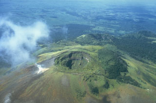 The summit crater of Las Pilas volcano (also known as El Hoyo) is 700 m wide and about 120 m deep. A prominent fumarole on the SE side of the crater emits a steam plume. Beyond and to the right of Las Pilas is the 900-m-high satellitic cone Cerro Ojo de Agua, itself capped with a 400-m-wide crater. The diagonal line cutting across from the summit crater of Las Pilas to the lower right was formed during an eruption in 1952.
Photo by Jaime Incer, 1981.
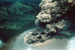 An ash plume rises above Cerro Negro on July 24, 1947. A strong explosive eruption beginning on July 9 produced ashfall that damaged crops at Malpaisillo and prompted evacuations of towns west of the volcano. Ash fell to the Pacific coast and to 7 inches on the roof of the cathedral at Leon. A NE-flank parasitic cone was formed and lava flows were emitted from both summit and flank vents. The eruption lasted until August 2, 1947.
Photo by Ray Wilcox, 1947 (U.S. Geological Survey).
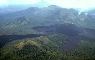 Both the closer part of the compound lava flow extending to the left margin of the photo beyond the vegetated Cerro la Mula cone at the lower left as well as the lighter-colored lava flow directly in front of Cerro Negro were emplaced during a major eruption in 1923. Cerro Negro erupted for seven weeks beginning October 23, 1923. Intense explosive activity increased the height of the cone to 300 m and left a 60-m-wide crater. The broad massif behind Cerro Negro is the Las Pilas complex, and conical Momotombo stratovolcano is in the background to the SE.
 Photo by Jaime Incer, 1980.
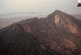 An aerial view of Mombacho from the SW shows the higher eastern summit of the twin-peaked volcano at the right. In the foreground is the southernmost of two large collapse scarps that cut the edifice. The other scarp, out of view on the NE flank beyond the ridge below the summit, was the source of a large debris avalanche that swept into Lake Nicaragua, forming the Aseses Peninsula and Las Isletas at the upper left.
Photo by Franco Penalba (courtesy of Jaime Incer), 1994.
 An archaeological site at Acahualinca near Managua exposes human footprints that were covered by voluminous pumice-fall deposits from Apoyeque volcano. The footprints are older than the overlying ca. 6500 yrs Before Present (BP) Jiloa Pumice and may occur within a ca. 7500 yrs BP mudflow deposit from Masaya volcano and thus range between about 6500 and 7500 yrs BP. These renowned footprints are the oldest indication of human habitation in the Managua area.
Photo by Jaime Incer.
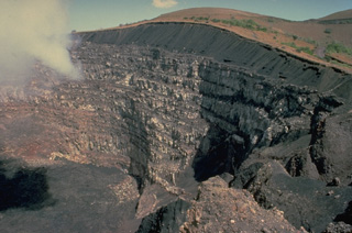 A thick stack of about 20 lava flows is exposed in the 230-m-high eastern walls of Santiago crater, overlain by a sequence of black basaltic ash deposits. The 600-m-wide Santiago crater is seen here from a viewpoint on the SW crater rim. Santiago crater is located on the west side of the post-caldera cone of Nindirí, and has been the source of most historical eruptions of Masaya.
Copyrighted photo by Katia and Maurice Krafft, 1983.
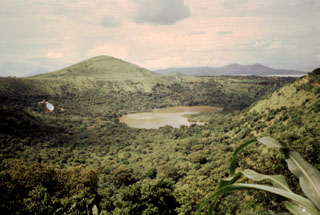 Laguna de Nejapa (right center) and Cerro Motastepe (left-center horizon) are part of the N-S-trending Nejapa-Miraflores alignment. A series of pit craters and fissure vents extends into Lake Managua (barely visible at the far upper right) and is continuous with the volcanic vents on the Chiltepe Peninsula (far right horizon). The Nejapa-Miraflores alignment (also known as Nejapa-Ticoma) has been the site of about 40 eruptions during the past 30,000 years, the most recent of which (from Cerro Motastepe) occurred less than 2500 years ago.
 Photo by Jaime Incer.
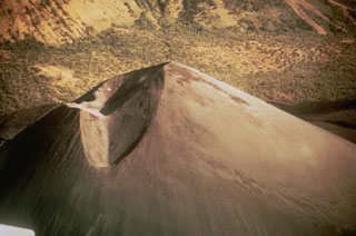 This December 1969 photo shows the crater of Cerro Negro a year after the end of the 1968 eruption. The two craters, separated by a narrow septum, are located north of the summit of the cone. The slopes of Las Pilas volcano are in the background. The morphologies of Cerro Negro's crater and summit have varied dramatically during the course of historical eruptions as a function of the location of the eruptive conduits, vigor of the eruptions, and direction of prevailing winds.
Photo by Willard Parsons, 1969 (courtesy of Bill Rose, Michigan Technological University).
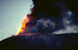 An incandescent lava fountain rises above the summit of Cerro Negro on November 30, 1995, as a plume of dark ash trails off to the right. Explosive eruptions took place from May 28 or 29 until August 16 and then again from November 19 to December 6. Incandescent bombs were ejected to 300-400 m above the rim of the 1992 crater on November 21. The ashfall caused much damage to farmlands.
 Photo by Britt Hill, 1995 (Southwest Research Institute).
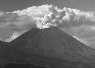 A vigorous steam plume pours from the summit crater of San Cristóbal volcano in December 1971, following an eruption that began on May 3. This mild explosive eruption lasted until early July. The 1971 activity marked the first documented eruptive activity at San Cristóbal since the 17th century. The volcano is seen here from the El Limón gold mine east of the volcano.
Photo by Dick Stoiber, 1971 (Dartmouth College).
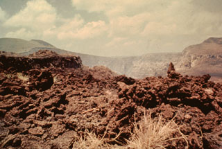 The 1670 lava flow from Nindirí crater in the background is seen here spilling over the crater rim. A series of lava lakes emplaced in 1670 eventually overflowed the rim through this narrow notch and produced a large lava flow that traveled 5 km down the north flank of the intracaldera cone.
Photo by Jaime Incer, 1977.
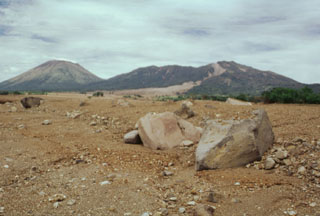 Rapidly moving fine-grained sediment and coarse boulders of a devastating lahar on 30 October 1998 obliterated evidence of the towns of El Porvenir and Rolando Rodriguez, which were located in the foreground area of this photo. The trace of the mudflow forms the light-colored scar extending from its source near the summit of Casita volcano (upper right). The devastating mudflow, which killed about 1600 people, was about 3 m deep at peak flow and 1.5 km wide at the location of the two towns. San Cristóbal volcano is at the upper left.
Photo by Paul Kimberly, 1998 (Smithsonian Institution).
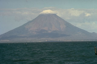 Concepción reaches about 1,700 m above Lake Nicaragua and is one of two volcanoes forming Ometepe Island. A small cone is visible on the lower SE flank (far right), one of the scoria cones, lava domes, and a tuff cone formed during flank eruptions.
Photo by Moser (courtesy of Jaime Incer).
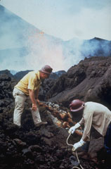 Scientists sample fumaroles near the flank vent at Cerro Negro in November 1968. Incandescent spatter is ejected from the vent in the background behind volcanologist Dick Stoiber (left), who led many expeditions from Dartmouth College to Central American volcanoes. This fumarole was a source of tenorite (CuO) and other minerals.
Photo by Dick Stoiber, 1968 (Dartmouth College).
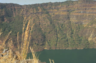 The steep-sided caldera walls of Cosigüina volcano rise 500 m above a lake on the caldera floor. Inter-bedded gray lava flows and brownish pyroclastic deposits forming the pre-caldera stratovolcano are exposed in the far wall. Observers of Cosigüina prior to the catastrophic 1835 eruption described the volcano as being of low height, with a flat top, suggesting that the caldera was in existence prior to the eruption.
Photo by Jaime Incer.
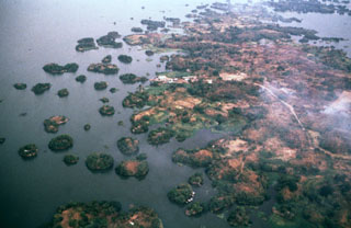 Las Isletas, or Isletas de Granada, are a cluster of about 500 small islands flanking the Aseses Peninsula extending into Lake Nicaragua. They were formed when the NE flank of Mombacho volcano collapsed, producing a debris avalanche that swept into the lake. A road leads down the peninsula to the settlement of El Diamante seen above the center of the photo. The peninsula is a resort area visited frequently from the nearby city of Granada. Many of the islands host vacation residences.
Photo by Jaime Incer.
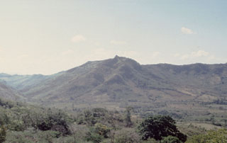 The SE side of Las Lajas caldera contains a narrow canyon (left, seen here from inside the eastern side of the caldera) through which the Quebrada Las Lajas drains into Lake Nicaragua. The caldera walls are up to 650 m high.
Photo by Benjamin van Wyk de Vries (Open University).
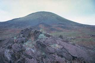 A tumulus on the surface of a pahoehoe lava flow in the foreground is exposed on the western flank of Masaya volcano, with Nindirí cone rising in the background. Nindirí is the westernmost cone of Masaya's summit complex and is cut by a large summit crater not apparent from this vantage point.
 Photo by Jaime Incer.
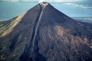 Dramatic levees flank the 1905 lava flow, which originated from the breached summit crater of Momotombo. The flow was confined in levees on the upper 1000 m of the cone before spreading laterally at the base of the volcano. Momotombo volcano towers to 1297 m above Lake Managua. The young cone forming the summit largely fills and overtops a 1.1 x 1.5 km wide crater produced during a major eruption about 2700-2800 years ago.
Photo by Jaime Incer, 1991.
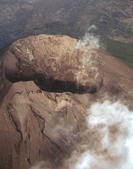 The Concepción summit crater is seen here in an aerial view from the west in 1994. The crater is 300 m in diameter and about 250 m deep.
 Photo by Jaime Incer, 1994.
 The broad Cosigüina stratovolcano (also spelled Cosegüina), is seen here from the SE across the Gulf of Fonseca. Cosigüina is the NW-most of a chain of active volcanoes stretching across Nicaragua. The 872-m-high volcano is truncated by a 2 x 2.4 km wide caldera that is filled by a lake. In 1835 Cosigüina was the source of Nicaragua's largest historical eruption, which produced detonations heard as far away as Guatemala. Pyroclastic flows and surges reached the Gulf of Fonseca and produced ephemeral islands.
Photo by Jaime Incer.
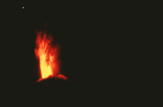 An incandescent eruption column rises above the summit of Cerro Negro in 1971. Major explosive eruptions February 3-14, primarily from the central vent, produced extensive crop damage over a 5000 km2 area and enlarged the summit crater from 150 to 400 m diameter.
 Photo by Jaime Incer, 1971.
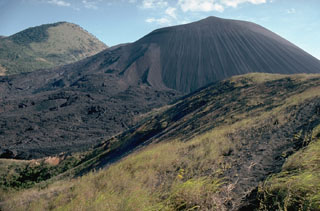 Cerro Negro, the largest and youngest of a group of four cinder cones that were constructed along a N-S line, is Central America's youngest volcano. Since its formation in 1850, Cerro Negro has produced frequent explosive eruptions, building a 250-m-high cinder cone surrounded by a fresh lava field. This 1995 photo from the southernmost of the older cones to the NNE shows flow levees and lava flows at the left side of Cerro Negro that were produced during the 1995 eruption. The vegetated peak in the background is part of the Las Pilas complex.
Photo by Britt Hill, 1995 (Southwest Research Institute).
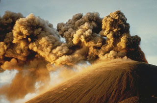 Strong winds deflect ash plumes from a strombolian eruption at the summit crater of Cerro Negro on November 8, 1968. This photo was taken from the south about two weeks after an eruption that began with flank activity on the night of October 23. The following day eruptions began from the summit crater. Plumes rose 1000-1500 meters, and heavy ashfall distributed by winds primarily to the west damaged 700 km2 of croplands. The eruption lasted until December 15.
Photo by Dick Stoiber, 1968 (Dartmouth College).
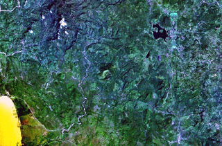 The small circular volcano at the center of this NASA Landsat image east (right) of the Río Pacora (left of center) is Cerro el Ciguatepe. This volcano lies in the Nicaraguan interior highlands, east of yellow-colored Lake Managua (lower left). A prominent breach can be seen in the SW wall of the well-preserved 1.5-km-wide crater. A small lava flow extends a short distance beyond the base of the cone through the breach, and a blocky plug dome was emplaced in the center of the crater. The dark-colored lake at the upper right is Laguna Moyua.
 NASA Landsat 7 image (worldwind.arc.nasa.gov)
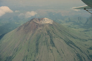 San Cristóbal, seen in this 1975 aerial view from the south, is the highest volcano in the Marrabios Range of western Nicaragua. The symmetrical, 1745-m-high stratovolcano is the youngest of five principal volcanoes forming the San Cristóbal complex. Young lava flows are located on its SW and northern flanks. Explosive eruptions have occurred since the beginning of the Spanish era. Cerro Moyotepe, a small composite volcano of the San Cristóbal complex that is cut by a series of N-S faults, appears at the right, below the plane wing.
Photo by Jaime Incer, 1975.
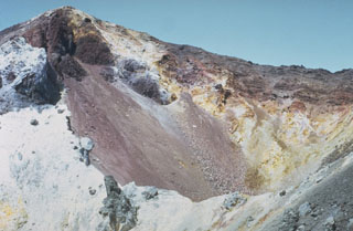 The summit crater of Cerro Negro is seen in March 1967, a year and half prior to the 1968 eruption. Light-colored areas result from heavy sublimate deposition. Frequent historical eruptions have greatly modified the morphology of Cerro Negro's summit crater.
 Photo by Bill Rose, 1967 (Michigan Technological University).
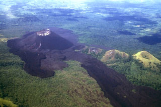 The short dark-colored lava flow in the left foreground and the left-hand, darker flow extending to the lower right-hand margin originated from a vent on the eastern flank of Cerro Negro during a September 4-24, 1957 eruption. In between these flows is an older lighter-colored flow that was erupted in 1947. The long 1957 flow lobe at the lower right overlies a slightly lighter-colored flow to its right that was emplaced in 1923. This view from the NE also shows older vegetated cones including Cerro la Mula, the grassy cone at the extreme right.
Photo by Jaime Incer, 1980.
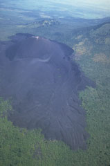 Prominent flow levees are visible on the surface of the 1968 lava flow from Cerro Negro in the foreground, marking individual flow lobes. This flow originated from a spatter cone (named Cristo Rey) on the south flank of Cerro Negro and traveled 1.5 km from the vent. Tephra covers and smooths the surface texture of an older flow in front of the cone to the left; this flow was emplaced during the 1960 eruption.
 Photo by Jaime Incer, 1980.
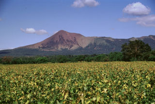 Telica volcano, seen here from the León-Chinandega highway, is one of a group of interlocking cones and vents along a NW trend. The summit of Telica, which is one of Nicaragua's most active volcanoes, is unvegetated, and deep erosional gulleys have been dissected into the lower flanks of the cone. Frequent historical eruptions have been recorded at Telica since the 16th century.
Photo by Lee Siebert, 1998 (Smithsonian Institution).
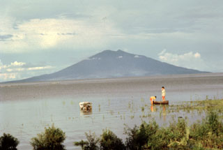 Maderas volcano rises to a height of 1394 m across a roughly 20-km-wide strait from the western shores of Lake Nicaragua. The volcano, also known as La Madera, is the SE-most of two large stratovolcanoes forming the dumbbell-shaped island of Ometepe. No historical eruptions are known from Maderas.
Photo by Jaime Incer.
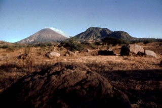 Boulders litter the foreground in this 1977 view of steaming San Cristóbal (left horizon) and Volcán El Chonco (right horizon). Immediately to the right of El Chonco on its western flank is Loma la Teta, a dacitic lava dome that postdates the collapse. Another small dome, Loma Caparra (barely visible here left of El Chonco and in front of the steaming San Cristóbal volcano in the background) was extruded on the northern flank of El Chonco. The 1105-m-high El Chonco lies at the western end of the San Cristóbal volcanic complex.
Photo by Alain Creusot-Eon, 1977 (courtesy of Jaime Incer).
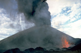 Ash falls at the left from a strombolian eruption column emanating from the summit crater of Cerro Negro volcano in 1968. At the same time incandescent spatter (lower right) is ejected from a small vent on the south flank of the cone. The 1968 eruption began on October 23 and lasted until December 15. The south-flank vent also fed a lava flow that traveled 1.5 km.
Photo by William Melson, 1968 (Smithsonian Institution).
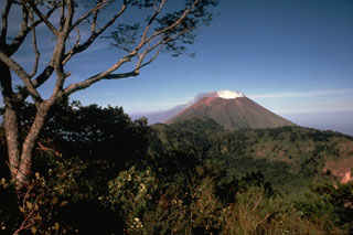 Steaming San Cristóbal volcano rises to the WNW beyond the rim of La Ollada, the 1-km-wide crater of Casita volcano. Fumarole activity along the northern wall of La Ollada has persisted since the early 16th century and does not exceed a temperature of 100 degrees Centigrade. This photo was taken from the summit of Casita volcano.
Photo by Alain Creusot-Eon, 1975 (courtesy of Jaime Incer).
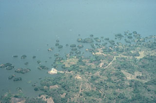 Las Isletas, a group of islands that were created by a large Holocene debris avalanche from Mombacho that swept into Lake Nicaragua. The avalanche traveled at least 12 km. The hummocky debris created an arcuate peninsula that extends into the lake as well as hundreds of small islands. This morphology is common where debris avalanches enter shallow bodies of water.
Photo by Jaime Incer, 1972.
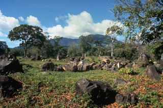 These angular boulders are part of a debris-avalanche deposit that originated from the south side of Mombacho volcano (seen in the background), most likely in 1570 CE. The avalanche traveled 13 km from Mombacho, and destroyed a village, killing 400 people.
Photo by Jaime Incer, 1972.
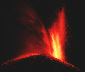 Incandescent ejecta from Cerro Negro volcano rising from a vent at the right reflects off the ash cloud to its left as glowing bombs litter the flanks of the cone. Cerro Negro began erupting on October 23, 1968 both from the summit vent, as seen here, and from a new vent on the south flank that produced a lava flow that traveled 1.5 km. Strong explosive eruptions damaged 700 km2 of cropland before the eruption ended on December 15.
Photo by Robert Citron, 1968 (Smithsonian Institution).
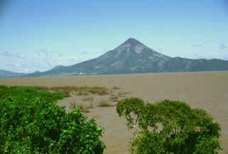 Conical Momotombo volcano rises above the shores of Lake Managua, its waters dirtied by floods associated with hurricane Mitch in 1998. Momotombo rises about 1250 m above the surface of the lake, which is only about 40 m above sea level. The dramatic volcano is one of Nicaragua's most prominent landmarks and is featured on many of the country's postage stamps.
Photo by Lee Siebert, 1998 (Smithsonian Institution).
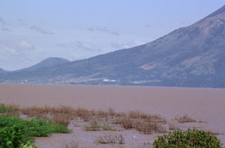 The buildings seen in the center of the photo along the shore of Lake Managua are part of the Patricio Arguello Ryan geothermal plant on the lower southern flank of Momotombo volcano. At one point the power plant produced 25% of electrical power generation for the country. In the distance on the left horizon is Cerro Montoso, a peak on the rim of Monte Galán caldera.
Photo by Paul Kimberly, 1998 (Smithsonian Institution).
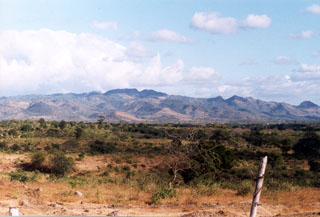 Las Lajas volcano rises on the horizon NE of the Nicaraguan central depression. It is the largest Quaternary volcano east of the depression and contains a 7-km-wide caldera.
Photo by Benjamin van Wyk de Vries (Open University).
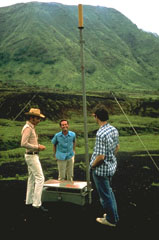 Early monitoring efforts at Masaya volcano included tilt meter stations such as this one, operated by the Instituto Nicaragüense de Estudios Territoriales (INETER). Inflation of the volcano's surface produced by ascent of magma can be detected by sensitive instruments such as the one installed here in 1976.
Photo by Dick Stoiber, 1976 (Dartmouth College).
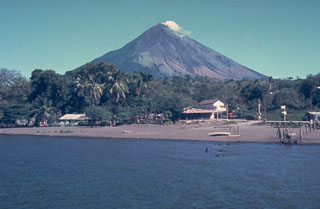 Concepción is one of Nicaragua's most active volcanoes. It forms the NW half of Ometepe island in Lake Nicaragua and is seen here from the SE from the isthmus connecting it to Madera volcano, which forms the SE end. Spatter cones, and scoria cones have formed during flank eruptions. Concepción has had frequent recent moderate explosive eruptions, many of which have originated from a summit crater.
Photo by Jaime Incer.
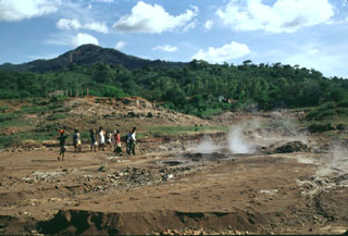 Forested Rota volcano rises above steaming ground of the San Jacinto thermal area at the eastern end of the Telica volcanic complex. Highway 26 between Telica and Malpaisillo crosses the low saddle between Rota and the Telica complex and provides easy access to the mud pots and steaming vents of the thermal area. Visitors to San Jacinto are accompanied by groups of vendors who live in settlements near the thermal area.
 Photo by Lee Siebert, 1998 (Smithsonian Institution).
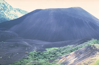 The Cerro Negro scoria cone formed in April 1850. It has been one of Nicaragua's most active volcanoes, building up a roughly 250-m-high cone surrounded by a field of young lava flows. Cerro Negro is seen here in 1981 from Cerro la Mula to the north, the next in a chain of four cinder cones erupted along a N-S line.
Photo by Mike Carr, 1981 (Rutgers University).
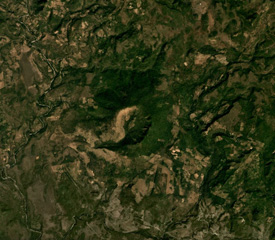 Cerro el Ciguatepe is in the center of this Planet Labs December 2019 satellite image monthly mosaic (N is at the top). It has a roughly 1.3-km-wide crater than opens towards the SW and a small lava flow extends a short distance beyond it.
Satellite image courtesy of Planet Labs Inc., 2019 (https://www.planet.com/).
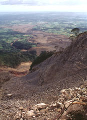 The course of the devastating debris avalanche and mudflow of October 30, 1998, is seen here from the top of the headwall scarp. Collapse of a relatively small area in the foreground (the western collapse scarp is the bare ridge at the right center) near the summit of Casita volcano produced an avalanche that transformed into a devastating mudflow and inundated lowland areas in the distance. The lahar overran two towns, which were located at the area in the sunlight at the upper left. The Pacific Ocean forms the horizon.
Photo by Lee Siebert, 1998 (Smithsonian Institution).
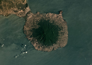 Maderas volcano forms the 12-km-wide SE part of Ometepe island, with Concepción out of view to the NE of this March 2019 Planet Labs satellite image monthly mosaic (N is at the top). The ridge on the SW flank is due to slumping and the ridge across the NE flank is due to normal faulting, creating a graben across the top of the edifice. A summit crater has formed within the graben.
Satellite image courtesy of Planet Labs Inc., 2019 (https://www.planet.com/).
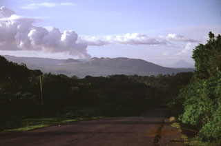 A vigorous gas plume is seen exiting from Masaya volcano in November 1998. Masaya's latest episode of degassing activity began in mid 1993. Prevailing winds typically distribute plumes from Masaya to the west, where they come in contact with the higher-elevation Las Sierras highlands (left horizon). The volcanic emissions during 1998-1999 affected a 1250 km2 area downwind, causing health hazards and extensive vegetation damage, resulting in economic losses to coffee plantations.
 Photo by Lee Siebert, 1998 (Smithsonian Institution).
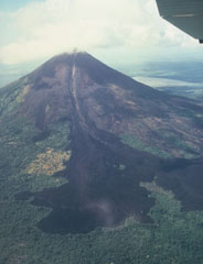 The 1905 lava flow originated from the breached summit crater and traveled down levees on the upper part of the cone before spreading laterally into forests at the NE base of Momotombo. A minor explosive eruption accompanied the lava flow, the latest of many flows that reached the base of the volcano.
 Photo by Jaime Incer, 1981.
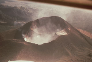 Steam fills the large double crater of Telica volcano in this 1968 aerial view from the NE. The crater is about 300 x 700 m wide; its morphology suggests several generations of crater formation. Most recent eruptions have occurred from the lower NE crater.
Photo by William Melson, 1968 (Smithsonian Institution).
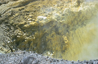 Precipitated sulfur lines the walls of a transverse fracture cutting the upper southern flank of Las Pilas volcano. The fissure extends from the upper SE flank to El Oyo pit crater on the upper SW flank. Fumaroles are particularly active at the SE end of the fissure.
Photo by Bill Rose, 1967 (Michigan Technological University).
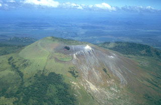 Las Pilas volcano is seen here in an aerial view from the south, with the dramatic El Hoyo pit crater below the summit at the left center. The arcuate ridge at the right beyond Las Pilas is the NE rim of a large crater cutting the older Cerro el Picacho volcano. The flat area in the background beyond Cerro el Picacho on the floor of the Nicaraguan depression is the Malpaisillo pyroclastic shield volcano.
 Photo by Jaime Incer, 1981.
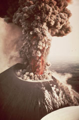 An eruption from Nicaragua's Cerro Negro volcano in 1968 produces an ash plume above the vent. Incandescent ejecta is visible at the base of the column. Gas and steam rise from fumaroles on the righthand side of the scoria cone. Ash and bombs fall from the eruption column at the left.
Photo by William Melson, 1968 (Smithsonian Institution).
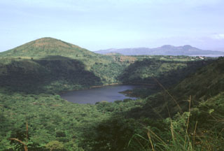 Cerro Motastepe cinder cone (upper left) is the youngest and most prominent feature of the Nejapa-Miraflores volcanic alignment. The cone, seen here from the SE with Laguna de Nejapa in the center of the photo, is elongated in an E-W direction and rises 160 m above its base to 360 m elevation. Cerro Motastepe formed less than 2500 years ago. The surface of saline Laguna de Nejapa collapse pit (center) lies at about the same level as Lake Managua, barely visible in the distance at the upper right.
 Photo by Lee Siebert, 1998 (Smithsonian Institution).
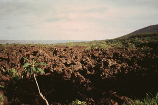 The fresh-looking lava flow in the foreground was erupted in 1772. On March 16 of that year lava emerged from a fissure on the north side of Old Masaya Crater, accompanied by bomb ejection. Part of the flow was diverted by the caldera wall and flowed into Masaya Lake, but much of the flow overtopped the caldera rim and traveled a total of 16 km to near the shores of Lake Managua, cutting the road between Nindirí and Managua and destroying croplands. The eruption lasted about 9 days.
Photo by Jaime Incer, 1994.
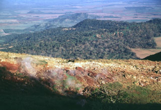 Steam rises from fumaroles in an area of hydrothermally altered ground east of the summit of Casita volcano. The forested slopes in the middle distance to the NE are the flanks of La Pelona caldera, whose floor forms the light-colored area at the right-center. The western part of the caldera was buried by lava flows and pyroclastic material from Casita.
Photo by Lee Siebert, 1998 (Smithsonian Institution).
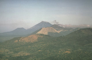 Cerro Negro volcano provides a vantage point for a NW-looking view down the Marrabios Range volcanic chain. The forested slopes in the foreground are part of Rota volcano. The light-colored conical peak in the center is Volcán Santa Clara, part of the Telica volcanic complex, whose principal peak, Telica itself, just pokes its head above the horizon behind and to the right of Santa Clara. The large conical peak on the center horizon is San Cristóbal, the highest peak of the Marrabios Range. The satellitic peak of El Chonco is on the left horizon.
Photo by Dennis Nielson, 1972 (courtesy of Mike Carr, Rutgers University).
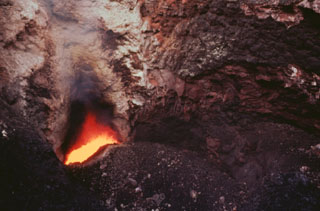 Incandescent magma is visible in 1996 at the bottom of Santiago crater from a vent below the south crater wall. A small strombolian eruption on December 5, 1996 ejected blocks (<10 cm in diameter), ash, and Pele's hair. Some of the inner crater walls collapsed, partly closing the incandescent vent. Prior to this eruption the vent's gas temperature was 1,084°C; afterwards, it dropped to 360°C.
 Photo by Jaime Incer, 1996.
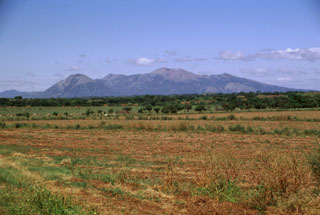 Las Pilas volcanic complex forms a broad massif seen here from the SSE rising above the Nicaraguan depression. This 30-km-long chain was erupted along a N-S-trending fissure and includes (from left to right) conical Asososca volcano, flat-topped Cerro Los Tacanistes, the unforested summit of Las Pilas itself (the high point of the range), and Cerro El Picacho.
Photo by Lee Siebert, 1998 (Smithsonian Institution).
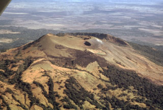 The flat light-colored area at the top of the photo beyond Las Pilas volcano in the foreground is the Malpaisillo caldera. This large but topographically indistinct pyroclastic shield volcano lies in the Nicaraguan depression NE of Las Pilas volcano and NNW of Momotombo volcano. Formation of the 10-km-wide Malpaisillo caldera produced extensively dissected dacitic airfall and ignimbrite deposits that extend across the graben east of the Marrabios Range and reach into Lake Managua to the SE.
 Photo by Jaime Incer, 1995.
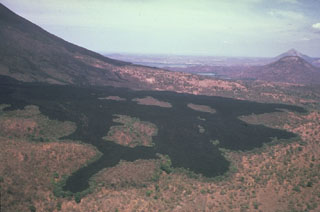 Successive lobes of the 1905 lava flow from Momotombo volcano in Nicaragua spread out on the flat slopes below the volcano, forming a broad terminus. This photo shows how lava flow direction is controlled by the topography, with individual lobes diverted around slightly higher areas of the pre-eruption surface, surrounding these prominent forested "islands" of older rock, known as kipukas.
Photo by Jaime Incer, 1982.
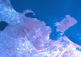 Two major scarps cutting Mombacho volcano (left-center) were the sources of major debris avalanches. The arcuate peninsula and island chain extending into Lake Nicaragua (known as Las Isletas or Isletas de Granada) was produced by collapse of Mombacho to the NE. The island at the right is Zapatera, a small shield volcano and maar complex. The lake at the far left fills late-Pleistocene Apoyo caldera, and the roughly N-S-trending Granada cinder cone alignment lies NNW of Mombacho and east of Lake Apoyo in this NASA Space Shuttle image (with north to the upper left).
NASA Space Shuttle image STS081-742-25, 1997 (http://eol.jsc.nasa.gov/).
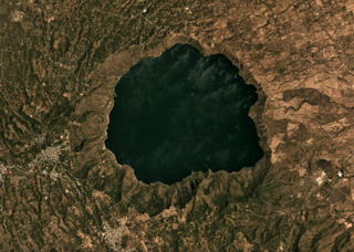 The 6.5-km-diameter Apoyo caldera formed during two Plinian eruptions around 24,000 years ago, seen in this March 2019 Planet Labs satellite image monthly mosaic (N is at the top; this image is approximately 13 km across). The caldera was created within broad lavas that formed the previous edifice.
Satellite image courtesy of Planet Labs Inc., 2019 (https://www.planet.com/).
 Volcán Azul consists of three scoria cones on the Atlantic coastal plain of Nicaragua, one of which is seen in the center of this October 2017 Planet Labs satellite image monthly mosaic (N is at the top). They each have craters 50-60 m across; the cone in the center has a basal diameter of approximately 410 m.
Satellite image courtesy of Planet Labs Inc., 2017 (https://www.planet.com/).
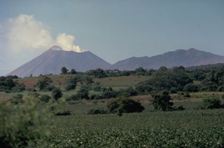 The San Cristóbal volcanic complex towers above the Plain of León to its south. A vigorous steam plume rises in 1978 above San Cristóbal (El Viejo) volcano at the left, the most recently active volcano of the complex. The irregular summit of Casita volcano (right) was formed by eruptions from several independent, partially overlapping craters along an E-W axis. Seven fumarolic areas are widely scattered over Casita volcano, which is also known as Chichigalpa.
Photo by Jaime Incer, 1978.
 San Cristóbal volcano, one of the most dramatic landmarks in Nicaragua, rises to 1745 m above cotton fields on its southern flank. This 1975 view of the volcano, also known as El Viejo, shows a strong gas plume drifting down its western flank. Persistent fuming has released large amounts of sulfur dioxide, destroying forests on this side of the volcano; the gas plume was strong enough to corrode barbed wire. Lava flows and explosive activity have occurred from lateral vents as well as from the large summit crater.
Photo by Jaime Incer, 1975.
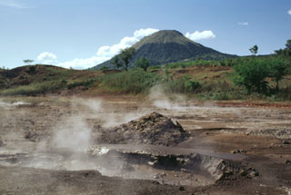 Mud pots and steaming vents of the San Jacinto thermal area lie at an elevation of 140 m at the eastern end of the Telica volcanic complex. Thermal manifestations cover a broad area here and along a N-S-trending fault at Tizate, about 2 km to the NNE. Conical Santa Clara volcano rises to 834 m in the background.
Photo by Lee Siebert, 1998 (Smithsonian Institution).
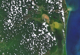 Volcán Azul (Volcán Blue) consists of three youthful cinder cones on the jungle-covered Atlantic coastal plain of Nicaragua. The cones are located at the lower left, west of Pearl Lagoon (right-center) and south of both the Río Grande de Matagalpa (which flows from the upper left to form the small point north of Pearl Lagoon) and the Río Curinhuás (left-center), which flows into the northern end of the lagoon. The three cones, each of which have well-defined, steep-walled craters, were first noted by geologists during an aerial overflight in the 1960s.
 NASA Landsat 7 image (worldwind.arc.nasa.gov)
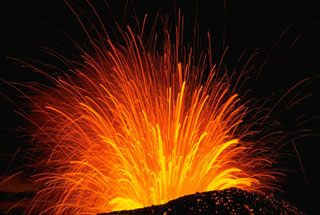 A long-exposure nighttime view of a Strombolian explosion at Cerro Negro volcano in Nicaragua in November 1968. The trajectory of individual incandescent volcanic bombs can be seen radiating from the vent. Hot, incandescent bombs are visible on the outer flanks of the scoria cone.
 Photo by Robert Citron, 1968 (Smithsonian Institution).
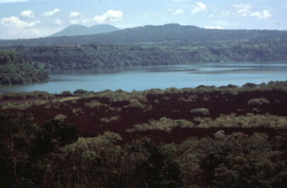 The sparsely vegetated lava flow in the foreground was emplaced during an eruption in 1772. The flow originated from a vent on the north side of Old Masaya crater and traveled to the north. One lobe passed through a notch in the northern caldera rim, while the lobe seen in this photo was deflected by the caldera rim and traveled to the SE into Lake Masaya, which is ponded against the SE caldera rim. The twin-peaked stratovolcano in the distance is Mombacho volcano.
Photo by Jaime Incer.
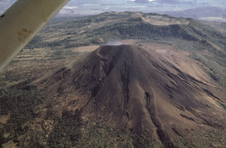 Telica's impressive summit crater is not visible in this aerial view from the west. Erosional gullies scar the flanks of the unvegetated cone. The broad ridge in the background is El Liston, an older part of the Telica volcanic complex. An E-W-trending line of shallow craters extends from Telica to the broad summit of El Liston.
Photo by Jaime Incer, 1991.
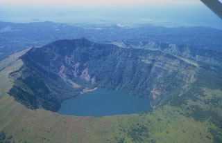 Cosigüina, seen here from the east, is a low basaltic-to-andesitic composite volcano that forms a large peninsula at the NW tip of Nicaragua along the Gulf of Fonseca. The 872-m-high volcano has a pronounced somma rim, which forms the ridge seen here at the right behind the far crater rim. The younger cone is truncated by a large elliptical prehistorical summit caldera 2 x 2.4 km in diameter and 500 m deep, which is now filled by a lake. It was the source of a major explosive eruption in 1835, Nicaragua's largest during historical time.
 Photo by Jaime Incer, 1981.
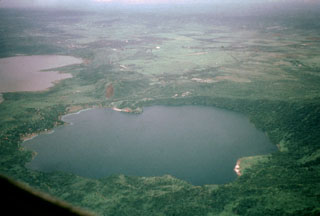 Laguna de Jiloa was the source of a major explosive eruption about 6500 years ago that deposited the widespread Jiloa Pumice, which blankets the Managua area. Laguna de Jiloa (also spelled Xiloa) is seen here in an aerial view from the north with Lake Managua at the upper left. The rim of the 2.5-km-wide caldera is lowest on the SE (left) and rises to 220 m on the NW side. Cones of the Nejapa-Miraflores alignment can be seen extending to the south from the center of the far caldera rim.
Photo by Jaime Incer, 1996.
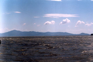 Zapatera Island is seen here from the north across Lake Nicaragua. The 629-m-high summit of the island at the left marks the rim of a fault-bound caldera. The post-caldera cone Cerro el Llano is a faintly visible conical peak whose summit lies just below the horizon near the center of the photo.
Photo by Benjamin Van Wyk de Vries (Open University).
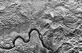 The indistinct caldera at the right-center is the eroded Tambor Grande caldera, one of several areas of Quaternary volcanic rocks along the Atlantic coastal plain at the SE tip of Nicaragua. The Río San Juan forms the boundary between Costa Rica on the south and Nicaragua on the north. Tambor Grande has preserved its morphology despite its occurrence within an area of heavy rain forest precipitation.
Radar image, 1971 (courtesy of Jaime Incer).
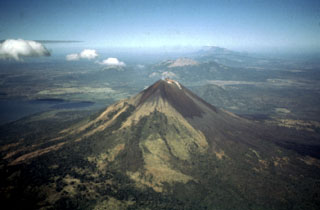 An aerial view to the NW looks down the spine of the Marrabios Range, which rises above the floor of the Nicaraguan depression. In the foreground is Momotombo volcano, which rises to 1297 m above the shores of Lake Managua (left). Monte Galán caldera lies beyond the right-hand flanks of Momotombo. Stretching across much of the photo beyond Momotombo is the N-S-trending Las Pilas complex, and the conical peak in the far distance is San Cristóbal volcano.
Photo by Jaime Incer, 1997.
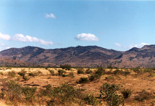 Cerro San Jacinto, also known as Cerro San Jacinto Viejo, is a small stratovolcano of probable early Pleistocene age constructed along the eastern margin of the Nicaraguan central graben east of Lake Managua. The central part of the volcano is seen here from the floor of the Nicaraguan depression along the road past Las Banderas. A large central depression is surrounded on the north and east by a horseshoe-shaped ridge, which is a remnant of a caldera rim.
 Photo by Benjamin van Wyk de Vries (Open University).
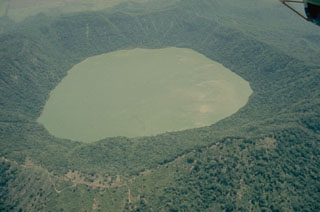 The forested Apoyeque stratovolcano is truncated by a 2.8-km-wide lake-filled caldera, seen here from the west. Another lake-filled caldera, Laguna de Jiloa, is located immediately to the SE.
Photo by Jaime Incer, 1975.
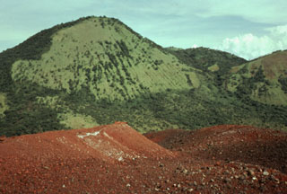 The vegetated peak Cerro Grande, a satellitic cone lying on the NW side of Las Pilas volcanic complex, rises to the SE above the reddish surface of Cerro Negro volcano in the foreground. At 1001 m, Cerro Grande is the second highest peak of the N-S-trending Las Pilas volcanic complex.
Photo by Franco Penalba, 1979 (courtesy of Jaime Incer).
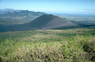 The unvegetated cone of Cerro Negro, the youngest volcano in Nicaragua, is seen here from the slopes of Las Pilas volcano at the end of its 1995 eruption. Lava flows in 1995 traveled to the NNE (right). Beyond Cerro Negro to the NW is the broad massif of Rota volcano. Unlike Telica and San Cristóbal volcanoes in the distance at the far upper left, Rota has had no historical eruptions.
 Photo by Britt Hill, 1995 (Southwest Research Institute).
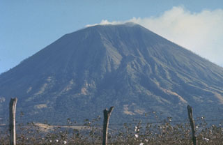 The less-often seen gullied northern flanks of San Cristóbal volcano rise above cotton fields at its base. San Cristóbal is a relatively recent name derived from a coffee plantation on its western flank; the volcano was previously known as El Viejo or Chinandega. It was used as a lighthouse for navigation by the British buccaneer Dampier when he sailed into the Bay of Corinto in July 1684. The following August he returned to the bay, but observed only smoking, rather than the "flames" he reported the previous year.
Photo by Jaime Incer, 1975.
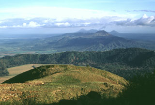 The oldest volcanic center of the San Cristóbal volcanic complex is La Pelona caldera, whose eastern wall forms the forested ridge in the center of the photo. Formation of the caldera was accompanied by the eruption of large amounts of dacitic pumice. Part of the caldera floor is visible at the left, but the western rim and floor has been buried by products of Casita volcano, where this photo was taken. The Marrabios Range volcanoes of Telica, Las Pilas, and conical Momotombo can be seen in the distance.
Photo by Lee Siebert, 1998 (Smithsonian Institution).
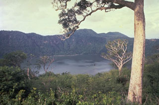 The summit caldera of Apoyeque volcano is filled by a scenic lake. The age of the latest eruption of Apoyeque is not known, but human footprints underlie pumice deposits thought to originate from Apoyeque volcano or a nearby vent beneath Lake Managua. This view is from the west caldera rim with the Chiltepe Hills in the background.
 Photo by Alain Creusset-Eon, 1970 (courtesy of Jaime Incer).
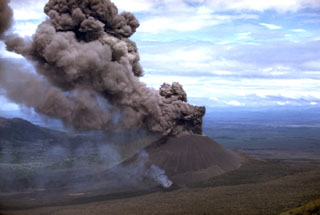 Winds deflect an ash column originating from the summit crater of Cerro Negro in 1968. At the same time a vent on the lower south flank, which is emitting a thin, lighter-colored steam column in this view, fed a lava flow. The advancing flow forms the black lobe extending to the lower left corner of the photo. The 1968 eruption began on October 23 and continued until December 15.
Photo by William Melson, 1968 (Smithsonian Institution).
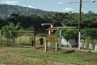 The San Jacinto-Tizate geothermal prospect at the eastern end of the Telica volcanic complex has undergone intermittent exploration by a Nicaraguan-Russian consortium. During the 1993-1995 period, seven exploration-production wells were drilled in the San Jacinto-Tizate geothermal area. The wells had total depths between 724 and 2235 m and encountered temperatures from 264 to 289 degrees Centigrade. Subsequent development by Polaris Geothermal resulted in inauguration of the first 10 MW production well in June 2005.
Photo by Paul Kimberly, 1998 (Smithsonian Institution).
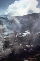 Abundant fumaroles in the summit crater of San Cristóbal volcano emit steam in this November 1973 photo. Trees in the foreground were killed by renewed fumarolic activity that began at San Cristóbal in May 1971 after a quiescence of about three centuries. The billowing cloud in the background is an atmospheric cloud.
Photo by Steve Swift, 1973 (courtesy of Dick Stoiber, Dartmouth College).
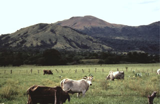 Las Pilas volcano (right center) rises above a cattle ranch on its SE side. The rounded eroded peak at the left is the older cone of Cerro Los Tacanistes. The floor of the Nicaraguan depression at this point is less than 100 m above sea level, a full kilometer below the summit of Las Pilas.
Photo by Jaime Incer, 1991.
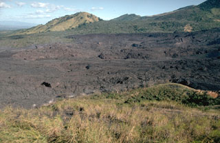 Lava flows from the 1995 eruption of Cerro Negro traveled to the NNE, overtopping earlier flows from eruptions in 1923, 1947, and 1957. The 1995 flows traveled a maximum distance of more than 2 km from a new vent within the 1992 summit crater. The flows mostly were emplaced between November 22 and December 2. They covered an area of 0.65 km2, and individual flow lobes had thicknesses of 2 to 10 meters.
 Photo by Britt Hill, 1995 (Southwest Research Institute).
 The 700-m-wide double summit crater of Telica volcano is seen here in an aerial view from the north with farmlands of the Nicaraguan depression in the background. The 1061-m-high volcano is the highest and most recently active of the Telica volcanic complex. The Telica volcano group consists of several interlocking cones and vents with a general NW alignment. The bench at the lower right and the ridge at the left are remnants of older craters of the complex.
Photo by Jaime Incer, 1991.
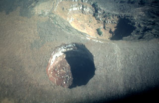 This dramatic near-vertical aerial photo looks down on El Hoyo, a spectacular pit crater near the summit of Las Pilas volcano. The pit crater, approximately 100 m in diameter, was formed by collapse. El Hoyo is located immediately south of the rim of the 700-m-wide summit crater of Las Pilas (upper right).
Photo by Franco Penalba, 1993 (courtesy of Jaime Incer).
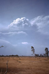 An eruption plume towers above Cerro Negro volcano in this April 1992 view from the south. Violent strombolian eruptions during April 9-14 produced heavy ashfall that caused extensive damage to buildings and croplands. The ash cloud extended 300 km to the WSW, with a maximum width of about 200 km. The eruption column was often clearly visible from Managua (60 km SE). Material ejected to about 7.5 km during more energetic pulses of the eruption was carried roughly 50 km NE by higher-altitude winds.
Photo by Jaime Incer, 1992.
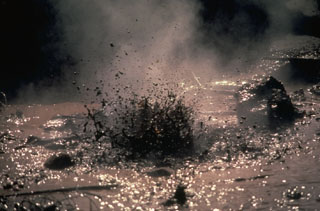 Mud pots boil in this 1978 view of the San Jacinto thermal area at El Salvador's Telica volcanic complex. The alignment of fumaroles and mud pots suggests an underlying fault running NNE. Magmatic steam and gases have been emitted from the thermal area for many years at a fairly constant rate.
Photo by Jaime Incer, 1978.
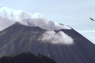 The steaming summit crater of San Cristóbal volcano is viewed here from the top of Casita volcano, whose western crater rim forms the ridge at the lower left. The SW crater rim (upper left) is 140 m above the NE rim, reflecting the influence of trade winds on tephra deposition. The 500 x 600 m wide crater is elongated in an E-W direction, and is several hundred meters deep.
Photo by Paul Kimberly, 1998 (Smithsonian Institution).
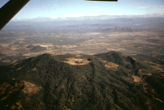 The deeply eroded, forested Rota stratovolcano is seen here in an aerial view from the south. The vegetated, 832-m-high volcano, also known as Orota, is truncated by a 1-km-wide circular crater. No historical eruptions are known from Volcán Rota, although seismic swarms occurred in 1986, 1989, and 1992. Two small NNW-SSE-trending lava domes, El Bosque (also known as Lomas San Ignacio del Bosque or Cerro Ojochal) form the small forested cones visible on the plain at the left center, 2 km north of the flank of Rota.
Photo by Jaime Incer, 1991.
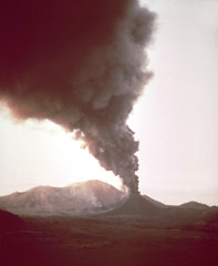 A dark ash-rich column rises above Cerro Negro volcano during the 1968 eruption. The heavy ash cloud was distributed by prevailing winds to the west, darkening the sky in that direction while Las Pilas volcano in the background remains in the sunlight. Ashfall damaged about 700 km2 of croplands.
Photo by William Melson, 1968 (Smithsonian Institution).
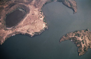 A cluster of maars forms the NW tip of Zapatera Island in this aerial view with north to the bottom. Laguna de Zapatera lies at the upper left, and Punta Rua, the peninsula at the upper right, forms part of the western rim of a maar enclosing the Ensenada de Chiqueros. Isla El Muerto lies just offshore at the lower right.
Photo by Franco Penalba, 1994 (courtesy of Jaime Incer).
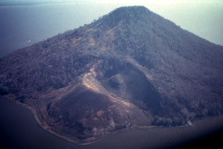 Isla Momotombito is a small 391-m-high island located immediately SE of Momotombo about 4 km off the coastline of Lake Managua. Punta Santa Ana, the peninsula in the foreground, consists of a young pyroclastic cone on the WSW side of the uninhabited, rattlesnake-infested island. Numerous archaeological sites have been found on the island.
Photo by Jaime Incer, 1993.
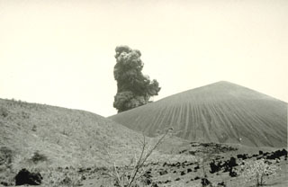 Violent strombolian eruptions 9-14 April 1992 produced heavy ashfall that caused extensive damage to buildings and croplands and forced the evacuation of 28,000 people. This photo shows a small explosive eruption from a vantage point 1 km SE of Cerro Negro during the final day of the 1992 eruption.
 Photo by Gerardo Soto, 1992 (Instituto Costarricense de Electricidad).
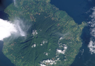 Maderas volcano, seen in this NASA International Space Station image with north to the upper right, forms the southeastern part of the dumbbell-shaped island of Ometepe. The roughly conical stratovolcano is cut by numerous faults and grabens, the largest of which is oriented NW-SE. The small Laguna de Maderas lake occupying summit crater is visible left of the center of this image. The satellitic Gorda pyroclastic cone forms the narrow peninsula at the right.
NASA International Space Station image ISS005-E-17746, 2002 (http://eol.jsc.nasa.gov/).
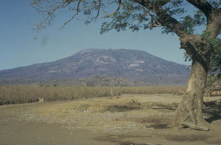 Las Pilas stratovolcano, seen here from the S, is the most prominent feature of Nicaragua's Las Pilas volcanic complex. Las Pilas rises to 900 m above its base in the Nicaraguan depression. Its broad summit contains a 700-m-wide crater and a N-S fissure that formed during an eruption in 1952.
 Photo by Bill Rose, 1967 (Michigan Technological University).
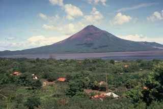 Momotombo is a young, 1297-m-high stratovolcano that rises prominently above the NW shore of Lake Managua, forming one of Nicaragua's most familiar landmarks. Seen here from the SW, Momotombo began growing about 4500 years ago and consists of a somma from an older edifice that is surmounted by a younger cone with a 150 x 250 m crater. Young lava flows from Momotombo have flowed down the NW flank into an unnamed, 4-km-wide caldera. Momotombo has a long record of strombolian eruptions, with occasional larger explosive activity.
Photo by Jaime Incer.
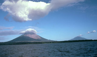 Concepción (left) and Maderas (right) form Ometepe island. They are seen here from the west, across a 10-20 km wide strait in Lake Nicaragua separating the island from the mainland. The volcanoes have formed on lake sediments overlying Tertiary-Cretaceous sediments.
 Photo by Jaime Incer.
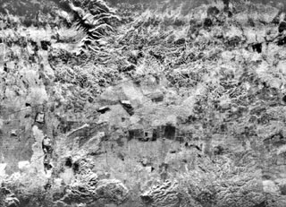 The flat-lying floor of the topographically indistinct 10-km-wide Malpaisillo pyroclastic shield volcano lies in the center of this radar image of the Nicaraguan depression. The Malpaisillo road crosses the image diagonally from the SW to the NE, and the town of Malpaisillo is outlined in black below the road at the left-center. Extensively dissected dacitic airfall and ignimbrite deposits are seen north of the 10-km-wide caldera, and lava flows from Las Pilas complex at the lower left lie SW of the caldera.
 Radar image, 1971 (courtesy of Jaime Incer).
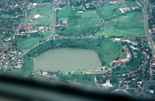 Laguna de Tiscapa partially fills a 700-m-wide maar on the outskirts of Managua, Nicaragua's capital city. The maar was constructed along a major fault that cuts through Managua. The rim of the crater overlooks the center of Managua and consequently has been the site of military fortifications dating back to the 18th century.
Photo by Jaime Incer, 1996.
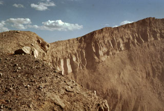 A jointed lava flow underlain and capped by pyroclastic ejecta is exposed in the western crater wall of Telica's NE summit crater, the source of most of the volcano's recent eruptions. The crater is about 300 m wide and several hundred meters deep.
Photo by Bill Rose, 1978 (Michigan Technological University).
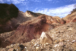 The devastating mudflow of October 30, 1998 originated from a small debris avalanche produced when part of the summit ridge of Casita volcano collapsed during torrential rains accompanying Hurricane Mitch. The source scarp, no more than a few hundred meters in length and a few tens of meters deep, is the light-colored area on the horizon at the upper left. The proximal part of the avalanche, deposits of which are seen in the right foreground, scoured into deeply hydrothermally altered rocks in the middle of the photo.
Photo by Lee Siebert, 1998 (Smithsonian Institution).
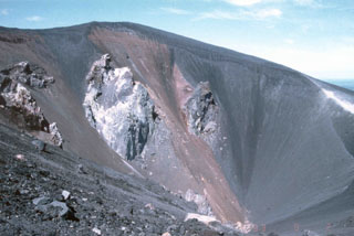 This September 1993 photo shows the morphology of the crater of Cerro Negro volcano after the 1992 eruption. Fumaroles observed during several visits by scientists to Cerro Negro on September 2-5 were issuing from circumferential fractures along the N rim of the crater and from what were interpreted as feeder dikes in the base of the crater. Fumaroles along the crater rim exhibited weak and variable degassing, with temperatures ranging from 79 to 90°C. Stronger fumaroles were confined to the feeder dikes within the crater.
Photo by Andrew MacFarlane, 1993 (Florida International University).
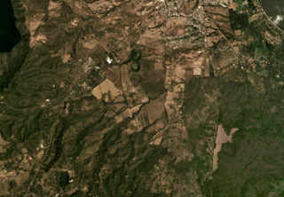 The Granada volcanic complex contains maars and scoria cones, with some shown in this February 2020 Planet Labs satellite image monthly mosaic (N is at the top; this image is approximately 9 km across). Near the center of this image is the N-S trending La Joya maar chain. SW of that are several scoria cones, one with a preserved crater and one with a quarry next to the road.
Satellite image courtesy of Planet Labs Inc., 2020 (https://www.planet.com/).
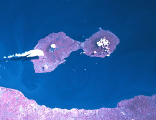 The dumbbell-shaped island of Ometepe, the largest in Lake Nicaragua (also known as Colcibolca), consists of two large stratovolcanoes, Concepción on the left and Maderas on the right. The two volcanoes were constructed on an unstable substrate of Tertiary-to-Cretaceous marine rocks and younger lake sediments, which has promoted spreading and deformation of the volcanic edifices. A low narrow isthmus connects Concepción to Maderas volcano. North lies to the upper left in this Space Shuttle image.
NASA Space Shuttle image STS081-742-25, 1997 (http://eol.jsc.nasa.gov/).
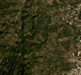 The area NW of the town of Estelí (lower right) contains vegetated lava flows of the Estelí volcanic field, shown in this December 2019 Planet Labs satellite image monthly mosaic (N is at the top; the image is approximately 10 km across). They were mostly erupted from vents in valleys within the northern interior highlands of Nicaragua between the town of Estelí and the border with Honduras.
Satellite image courtesy of Planet Labs Inc., 2019 (https://www.planet.com/).
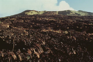 The 1670 lava flow covering much of this photo originated from Nindirí crater on the horizon. A lava lake in the crater eventually overflowed the rim, producing a lava flow that traveled from Nindirí crater for 5 km down the northern flank of Masaya's post-caldera cone. Some accounts confused the 1670 flow from Nindirí with the 1772 flow from Old Masaya crater.
Photo by Jaime Incer, 1994.
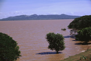 The broad Chiltepe Peninsula rises to the SE across the flood-stained waters of Lake Managua. Apoyeque caldera lies beyond its horizontal rim on the right-center horizon. The 11-km-wide peninsula extends into Lake Managua and marks the northern limit of a segment of the central Nicaraguan volcanic chain that is offset to the east.
Photo by Lee Siebert, 1998 (Smithsonian Institution).
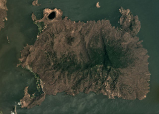 The roughly 7 x 10 km Zapatera island contains more than 30 vents across 150 km2, shown in this March 2019 Planet Labs satellite image monthly mosaic (N is at the top; this image is approximately 12 km across). The island is heavily faulted due to the Ochomogo fault zone, and a 150-m-high scarp is along the center.
Satellite image courtesy of Planet Labs Inc., 2019 (https://www.planet.com/).
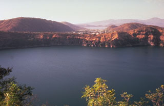 The steep-walled crater Laguna de Asososca provides water for the adjacent capital city of Managua. The elongated 1.3 x 1 km wide lake lies north of Laguna de Nejapa along the Nejapa-Miraflores lineament and is viewed here from the SE. In the background, beyond a bay of Lake Managua (the light-colored body of water at the upper right-center), is the Chiltepe Peninsula. This Laguna de Asososca is not to be confused with another crater lake of the same name at the southern end of the N-S-trending Las Pilas volcanic complex.
Photo by Jaime Incer.
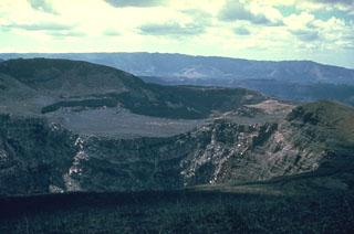 Three Masaya summit craters are visible in this view to the NW; Santiago crater appears in the foreground, with the flat, high surface of Nindirí crater in the middle and San Pedro crater behind it. The flat-lying, lighter-colored lavas in the center are a part of a lava lake emplaced in Nindirí crater during an eruption in July 1852. A small lava flow was also emitted at that time, a few years before the formation of Santiago and San Pedro pit craters in 1858-1859. The NW wall of Masaya caldera forms the low ridge in the middle distance.
Photo by Dick Stoiber, 1963 (Dartmouth College).
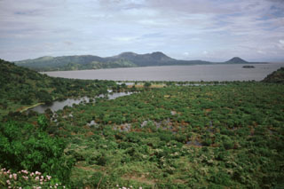 The Chiltepe Peninsula is seen across Lake Managua from the south on the outskirts of the city of Managua. The broad peninsula extends into the lake about 6 km north of the city and lies at the northern end of a chain of pyroclastic cones and craters that extends into the city. The small conical peak on the far right horizon is Volcán Chiltepe.
Photo by Lee Siebert, 1998 (Smithsonian Institution).
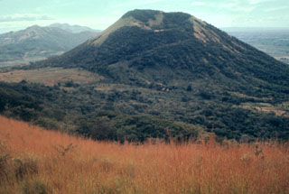 Volcán Santa Clara lies across a 400-m-high saddle (left) from Telica volcano. The crater rim of 834-m-high Santa Clara is higher on its far SE side and is breached to the NW. Santa Clara was considered to be active during the 16th century, but these reported eruptions more likely originated from Telica.
Photo by Alain Creusot-Eon, 1977 (courtesy of Jaime Incer).
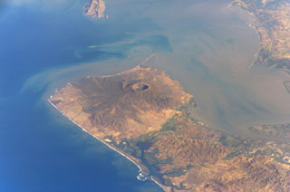 Cosigüina volcano forms the northern half of a 25-km-wide peninsula extending NW-ward into the Gulf of Fonseca. A 2-km-wide caldera, partially filled by a lake, truncates the summit of the volcano, and the scarp of a larger older caldera is visible to the NW. Pyroclastic flows from the catastrophic 1835 eruption, the largest in Nicaragua during historical time, reached the Gulf of Fonseca. The volcanic island of Meanguera in the El Salvador side of the Gulf of Fonseca is visible at the top left.
NASA International Space Station image ISS004-E-9143, 2002 (http://eol.jsc.nasa.gov/).
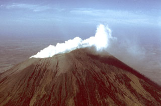 A vigorous white steam plume, seen here from the NW, rises from the summit crater of San Cristóbal volcano in March 1976. Small ash eruptions occurred from San Cristóbal on March 9-10, 1976, dropping ash on the town of Chinandega, 10 km to the SW. Ashfall from another eruption on March 16 was restricted to the summit crater area. Collapse of cones within the summit crater during this eruption created a new 300-m-wide vent.
Photo by Dick Stoiber, 1976 (Dartmouth College).
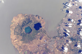 Two lake-filled calderas dominate the 11-km-wide Chiltepe Peninsula extending NE-ward into Lake Managua. Greenish Lake Apoyeque was the source of two major late-Pleistocene plinian pumice deposits, and dark-blue Lake Jiloa (Xiloa) produced the Jiloa Pumice about 6500 years ago. The two calderas cut the summit of the Chiltepe pyroclastic shield volcano. Nicaragua's capital city Managua, extending across much of the right side of the image, has been subjected to major tectonic earthquakes.
 NASA International Space Station image ISS004-E-5765, 2002 (http://eol.jsc.nasa.gov/).
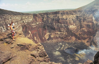 Steep-walled Santiago crater provides a dramatic perspective into the vent of an active volcano. The crater floor is covered by recent lava flows and fume rises from an inner crater. The walls of the 600-m-wide crater expose stacked lava flows, truncated lava lakes, and pyroclastic material erupted from earlier vents.
 Photo by Jaime Incer.
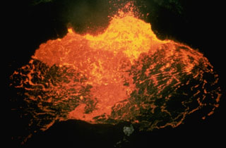 A new lava lake appeared on the floor of Santiago Crater in October 1965, marking the beginning of Masaya's third 20th-century lava-lake cycle. By 1969 activity was restricted to a small spatter cone in the center of the crater. Several lava flows erupted on the crater floor between 1965 and 1972. The spatter cone collapsed in 1972 and lava lake activity was visible until 1979, when activity subsided and was followed by dense gas emissions. Small ash eruptions took place on single days in 1981, 1982, 1984, and 1985.
Photo by Jaime Incer.
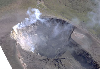 Most recent eruptions of Telica have occurred from the lower NE summit crater. Fumarolic plumes rise from its floor and just below its rim. The double summit crater is about 300 x 700 m wide. Erosional gullies extend into the NE crater from the shallower SW crater. It lies below the summit, which is out of view below the bottom of the photo.
Photo by Robert Citron, 1968 (Smithsonian Institution).
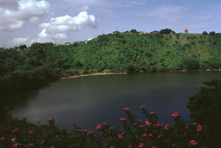 A restaurant on the rim of Laguna de Tiscapa provides a scenic view of the a 700-m-wide maar on the outskirts of Managua, Nicaragua's capital city. The maar was constructed along a major fault that cuts through Managua. The crater overlooks the center of Managua and lies 5 km east of the N-S-trending Nejapa-Miraflores lineament, a 17-km-long chain of collapse pits and cinder-spatter cones that marks a point of right-lateral offset of the Nicaraguan volcanic chain.
Photo by Lee Siebert, 1998 (Smithsonian Institution).
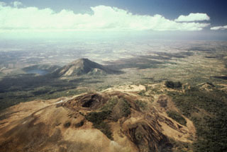 Volcán Las Pilas lies in the foreground in this aerial view of Las Pilas volcanic complex from the north. The diagonal line cutting across from left of the summit crater to the bottom center is the fissure from the 1952 eruption. The forested crater at the middle right is Cerro Ojo de Agua. The conical peak in the middle distance is Cerro Asososca, and immediately to its left is Laguna de Asososca maar. Two other dry maars are located in the Nicaraguan depression between Laguna de Asososca and the tip of Lake Managua at the upper left.
Photo by Alain Creusot-Eon, 1980 (courtesy of Jaime Incer).
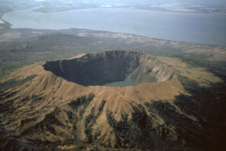 A dramatic aerial view from the NW shows Cosigüina volcano with its 2.4-km-wide caldera. One of Central America's largest historical eruptions began on January 20, 1835. Detonations were heard in Jamaica, Venezuela, and Colombia, and ash fell throughout Central America and southern México. Pyroclastic flows and surges reached the Gulf of Fonseca (background), and fountain-fed lava flows mantled portions of the upper flanks. Although the eruption devastated croplands and livestock, there were few human fatalities.
 Photo by Jaime Incer, 1991.
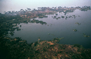 The arcuate Aseses Peninsula extending 5 km into Lake Nicaragua was formed when the NE flank of Mombacho volcano collapsed producing a highly mobile debris avalanche that swept into the lake. Flanking the peninsula are hundreds of small islands, known as Las Isletas, or Isletas de Granada. These are the tops of hummocky terrain formed of debris from the avalanche, which traveled as far as 12 km from the volcano.
Photo by Jaime Incer.
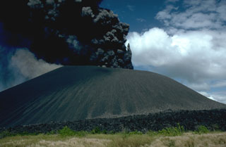 A dark, ash-rich eruption column rises above Cerro Negro volcano on December 1, 1995, near the end of an eruption that began on May 28 or 29. Minor ash eruptions continued intermittently until August 16. A small lava flow appeared in the main crater on July 24. The most intense activity on June 2 was accompanied by a very small pyroclastic surge. Explosive activity resumed from November 19 to December 6, and was accompanied by growth of a small lava dome in the summit crater and lava flows that traveled down the north flank.
Photo by Britt Hill, 1995 (Southwest Research Institute).
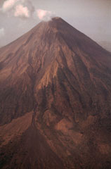 The SW flank of Concepción has been altered by mass-wasting processes. This 1992 photo shows the effects of many rockfalls, as well as small landslides of ash and scoria on the west and south flanks. The SW gully has discharged a large amount of sediment since 1983, forming a fan (lower left) that by 1986 had buried 500 m of mature forest. Areas as far away as communities 8 km SW of the crater were affected, and some homes had to be abandoned.
Photo by Franco Penalba, 1992 (courtesy of Jaime Incer).
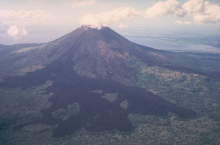 During the latest eruption of Momotombo volcano, in 1905, a large lava flow issued from the breached NE side of the summit crater and traveled 4.5 km onto the lower flanks. The brief, 5-day-long eruption began on January 16 and was accompanied by minor explosive activity. Several prominent "kipukas," (islands of older terrain) are visible in this view from the north with Lake Managua in the background.
Photo by Jaime Incer, 1981.
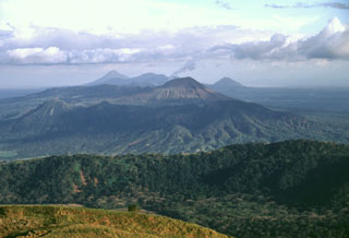 A view from Casita volcano to the SE along the Marrabios Range shows the Telica volcanic complex covering much of the center of the photo. A thin steam plume rises from the summit of Telica itself (right-center), while the cone of Cerro de Aguero lies at the left-center, with shadows defining older, more dissected parts of the Telica complex. The forested ridge of La Pelona caldera (part of the San Cristóbal complex) cuts across the lower part of the photo, while Momotombo (left), Las Pilas, and Cerro Asososco (right) lie on the horizon.
Photo by Lee Siebert, 1998 (Smithsonian Institution).
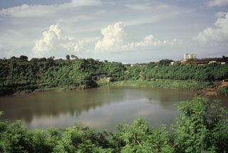 Laguna de Tiscapa is seen here from the SW with a skyscraper of downtown Managua in the right background. The 700-m-wide maar overlooks the central part of the city. Laguna de Tiscapa lies about 5 km east of the Nejapa-Miraflores crater lineament along a major fault that cuts through the city of Managua.
Photo by Jaime Incer.
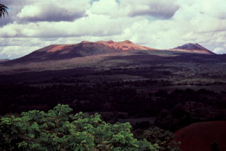 The Masaya central cone complex within the Holocene Masaya caldera (foreground) lies within a larger Pleistocene caldera, the Las Sierras (or Las Nubes) caldera, which was formed following the eruption of a major ignimbrite about 30,000 years ago. The ignimbrite deposit from this eruption is found in the Managua area, where it is cut by faults of the Managua Graben, which extends to the north, constraining the SE margins of Lake Managua.
Photo by Jaime Incer, 1990.
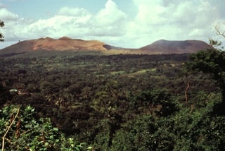 Masaya (left) and Nindirí (right) cones are seen here from the NW across the floor of Masaya caldera. Santiago crater, the source of most of Masaya's historical eruptions, lies in the saddle between the two cones. Historical and prehistorical lava flows blanket the caldera floor.
Photo by Jaime Incer, 1990.
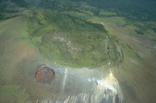 The summit crater of Las Pilas volcano is 700 m wide and 120 m deep. Concentric fissures illustrate its collapse origin. Steam rises from fumaroles along a transverse fissure that extends from the lower right to the upslope (northern) side of the dramatic El Hoyo pit crater at the lower left.
 Photo by Jaime Incer 1981.
This is a compilation of Nicaragua volcano information sources, such as official monitoring or other government agencies.
| Volcano Observatories | |
|---|---|
| Istituto Nicaraguense de Estudios Territoriales (INETER) | |
| - INETER Activity Reports | |
| - INETER Archives | |
| Civil Protection Agencies | |
|---|---|
| Sistema Nacional para la Prevención, Mitigación y Atención de Desastres (SINAPRED) | |
| Volcanic Ash Advisory Center | |
|---|---|
| Washington Volcanic Ash Advisory Center (VAAC) | |
| - Washington VAAC Archive | |
| - Washington VAAC Notices | |