The Global Volcanism Program has no activity reports available for Floreana.
The Global Volcanism Program has no Weekly Reports available for Floreana.
The Global Volcanism Program has no Bulletin Reports available for Floreana.
|
|
||||||||||||||||||
There is data available for 0 confirmed eruptive period.
[ 1813 Jul ] Discredited Eruption
This compilation of synonyms and subsidiary features may not be comprehensive. Features are organized into four major categories: Cones, Craters, Domes, and Thermal Features. Synonyms of features appear indented below the primary name. In some cases additional feature type, elevation, or location details are provided.
Synonyms |
||||
| Santa Maria | Charles | ||||
Cones |
||||
| Feature Name | Feature Type | Elevation | Latitude | Longitude |
| Caldwell Island | Tuff cone | |||
| Champion Island | Tuff cone | |||
| Cormorant Point | Tuff cone | |||
| Enderby Island | Tuff cone | |||
| Gemelos, Cerro de los | Cone | |||
| Olympus, Mount
Wittmerberg |
Cone | |||
| Pajas, Cerro de | Cone | 640 m | ||
| Ritter | Cone | |||
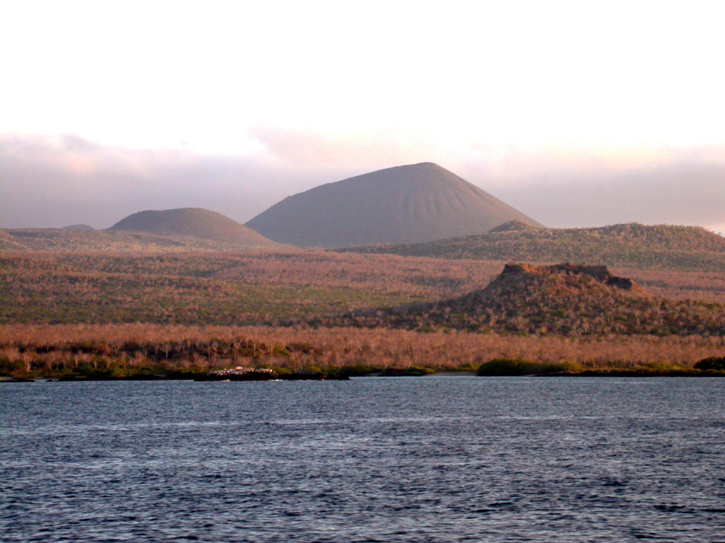
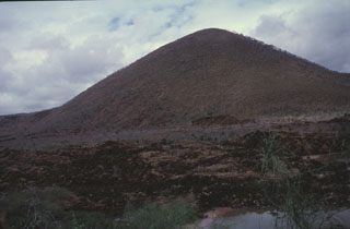 A sparsely vegetated lava flow appears in the foreground below Cerro Pajas, one of the more than 50 cinder cones dotting Floreana Island. Several young lava flows on Floreana, also known as Charles Island or Santa María Island, were considered due to their morphology to be Holocene, but Pleistocene surface exposure ages were obtained. Cerro Pajas, the most conspicuous of the cinder cones on the island, fed a massive pahoehoe lava flow that reached the SW coast over a broad 6.5 km area.
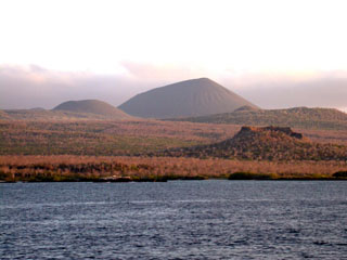 Floreana Island (also known as Charles Island or Santa María Island) is a broad shield volcano whose surface is densely covered with cinder cones. The most conspicuous of these is Cerro de Pajas, seen here from the north with a spatter cone in the right foreground. A massive pahoehoe lava flow from Cerro de Pajas, perhaps the youngest on Floreana, reached the SW coast over a broad 6.5 km area. The youngest lava flow on Floreana, once thought to be Holocene, has a late Pleistocene surface exposure age.
There are no samples for Floreana in the Smithsonian's NMNH Department of Mineral Sciences Rock and Ore collection.
| Copernicus Browser | The Copernicus Browser replaced the Sentinel Hub Playground browser in 2023, to provide access to Earth observation archives from the Copernicus Data Space Ecosystem, the main distribution platform for data from the EU Copernicus missions. |
|
WOVOdat
Single Volcano View Temporal Evolution of Unrest Side by Side Volcanoes |
WOVOdat is a database of volcanic unrest; instrumentally and visually recorded changes in seismicity, ground deformation, gas emission, and other parameters from their normal baselines. It is sponsored by the World Organization of Volcano Observatories (WOVO) and presently hosted at the Earth Observatory of Singapore.
GVMID Data on Volcano Monitoring Infrastructure The Global Volcano Monitoring Infrastructure Database GVMID, is aimed at documenting and improving capabilities of volcano monitoring from the ground and space. GVMID should provide a snapshot and baseline view of the techniques and instrumentation that are in place at various volcanoes, which can be use by volcano observatories as reference to setup new monitoring system or improving networks at a specific volcano. These data will allow identification of what monitoring gaps exist, which can be then targeted by remote sensing infrastructure and future instrument deployments. |
| IRIS seismic stations/networks | Incorporated Research Institutions for Seismology (IRIS) Data Services map showing the location of seismic stations from all available networks (permanent or temporary) within a radius of 0.18° (about 20 km at mid-latitudes) from the given location of Floreana. Users can customize a variety of filters and options in the left panel. Note that if there are no stations are known the map will default to show the entire world with a "No data matched request" error notice. |
| UNAVCO GPS/GNSS stations | Geodetic Data Services map from UNAVCO showing the location of GPS/GNSS stations from all available networks (permanent or temporary) within a radius of 20 km from the given location of Floreana. Users can customize the data search based on station or network names, location, and time window. Requires Adobe Flash Player. |
| Large Eruptions of Floreana | Information about large Quaternary eruptions (VEI >= 4) is cataloged in the Large Magnitude Explosive Volcanic Eruptions (LaMEVE) database of the Volcano Global Risk Identification and Analysis Project (VOGRIPA). |
| EarthChem | EarthChem develops and maintains databases, software, and services that support the preservation, discovery, access and analysis of geochemical data, and facilitate their integration with the broad array of other available earth science parameters. EarthChem is operated by a joint team of disciplinary scientists, data scientists, data managers and information technology developers who are part of the NSF-funded data facility Integrated Earth Data Applications (IEDA). IEDA is a collaborative effort of EarthChem and the Marine Geoscience Data System (MGDS). |

