Ecuador Volcanoes
Ecuador has 36 Holocene volcanoes. Note that as a scientific organization we provide these listings for informational purposes only, with no international legal or policy implications. Volcanoes will be included on this list if they are within the boundaries of a country, on a shared boundary or area, in a remote territory, or within a maritime Exclusive Economic Zone. Bolded volcanoes have erupted within the past 20 years. Suggestions and data updates are always welcome ().
| Volcano Name | Last Eruption | Volcanic Region | Primary Landform |
|---|---|---|---|
| Alcedo | 1993 CE | Galapagos Hotspot Volcano Group | Shield |
| Aliso | 2450 BCE | Northern Andean Volcanic Arc | Composite |
| Antisana | 1802 CE | Northern Andean Volcanic Arc | Composite |
| Atacazo | 320 BCE | Northern Andean Volcanic Arc | Composite |
| Cerro Azul | 2008 CE | Galapagos Hotspot Volcano Group | Shield |
| Cayambe | 1786 CE | Northern Andean Volcanic Arc | Composite |
| Chacana | 1773 CE | Northern Andean Volcanic Arc | Caldera |
| Chachimbiro | 3740 BCE | Northern Andean Volcanic Arc | Composite |
| Chiles-Cerro Negro | 1936 CE | Northern Andean Volcanic Arc | Composite |
| Chimborazo | 550 CE | Northern Andean Volcanic Arc | Composite |
| Cotopaxi | 2023 CE | Northern Andean Volcanic Arc | Composite |
| Cuicocha | 650 CE | Northern Andean Volcanic Arc | Caldera |
| Darwin | 1813 CE | Galapagos Hotspot Volcano Group | Shield |
| Ecuador | 1150 CE | Galapagos Hotspot Volcano Group | Shield |
| Fernandina | 2024 CE | Galapagos Hotspot Volcano Group | Shield |
| Galapagos Rift at 86°W | 1996 CE | Galapagos Rift Volcanic Province | Cluster |
| Genovesa | Unknown - Evidence Credible | Northern Galapagos Volcanic Province | Shield |
| Guagua Pichincha | 2002 CE | Northern Andean Volcanic Arc | Composite |
| Iliniza | Unknown - Evidence Credible | Northern Andean Volcanic Arc | Composite |
| Imbabura | 5550 BCE | Northern Andean Volcanic Arc | Composite |
| Licto | Unknown - Evidence Uncertain | Northern Andean Volcanic Arc | Minor (Basaltic) |
| Marchena | 1991 CE | Northern Galapagos Volcanic Province | Shield |
| Mojanda | Unknown - Evidence Uncertain | Northern Andean Volcanic Arc | Composite |
| Sierra Negra | 2018 CE | Galapagos Hotspot Volcano Group | Shield |
| Pinta | Unknown - Eruption Observed | Northern Galapagos Volcanic Province | Shield |
| Pululahua | 290 CE | Northern Andean Volcanic Arc | Caldera |
| Quilotoa | 1280 CE | Northern Andean Volcanic Arc | Caldera |
| Reventador | 2025 CE | Northern Andean Volcanic Arc | Composite |
| San Cristobal | Unknown - Evidence Credible | Galapagos Hotspot Volcano Group | Shield |
| Sangay | 2025 CE | Northern Andean Volcanic Arc | Composite |
| Santa Cruz | Unknown - Evidence Credible | Galapagos Hotspot Volcano Group | Shield |
| Santiago | 1906 CE | Galapagos Hotspot Volcano Group | Shield |
| Soche | 6650 BCE | Northern Andean Volcanic Arc | Composite |
| Sumaco | 1895 CE | Northern Andean Volcanic Arc | Composite |
| Tungurahua | 2016 CE | Northern Andean Volcanic Arc | Composite |
| Wolf | 2022 CE | Galapagos Hotspot Volcano Group | Shield |
Chronological listing of known Holocene eruptions (confirmed or uncertain) from volcanoes in Ecuador. Bolded eruptions indicate continuing activity.
| Volcano Name | Start Date | Stop Date | Certainty | VEI | Evidence |
|---|---|---|---|---|---|
| Fernandina | 2024 Mar 2 | 2024 May 8 | Confirmed | Observations: Satellite (visual) | |
| Cotopaxi | 2022 Oct 21 | 2023 Jul 6 | Confirmed | 2 | Observations: Reported |
| Wolf | 2022 Jan 6 | 2022 Apr 14 | Confirmed | 2 | Observations: Reported |
| Fernandina | 2020 Jan 12 | 2020 Jan 13 | Confirmed | 0 | Observations: Reported |
| Sangay | 2019 Mar 26 | 2025 Dec 17 (continuing) | Confirmed | 2 | Observations: Reported |
| Sierra Negra | 2018 Jun 26 | 2018 Aug 23 | Confirmed | 2 | Observations: Reported |
| Fernandina | 2018 Jun 16 | 2018 Jun 21 | Confirmed | 1 | Observations: Reported |
| Sangay | 2018 Jun 8 (?) | 2018 Dec 17 | Confirmed | 2 | Observations: Reported |
| Sangay | 2018 Feb 25 | 2018 Feb 25 | Confirmed | 1 | Observations: Reported |
| Fernandina | 2017 Sep 4 | 2017 Sep 8 ± 1 days | Confirmed | 1 | Observations: Reported |
| Sangay | 2017 Jul 20 | 2017 Oct 19 | Confirmed | 2 | Observations: Reported |
| Sangay | 2016 Mar 17 ± 2 days | 2016 Nov 17 | Confirmed | 2 | Observations: Satellite (infrared) |
| Cotopaxi | 2015 Aug 14 | 2016 Jan 24 | Confirmed | 3 | Observations: Reported |
| Wolf | 2015 May 25 | 2015 Jul 16 | Confirmed | 4 | Observations: Reported |
| Sangay | 2015 Jan 18 | 2015 Apr 7 | Confirmed | 2 | Observations: Reported |
| Sangay | 2013 Jan 25 | 2013 May 24 | Confirmed | 2 | Observations: Reported |
| Tungurahua | 2012 Dec 14 | 2016 Mar 16 | Confirmed | 3 | Observations: Reported |
| Tungurahua | 2011 Nov 27 | 2012 Sep 4 | Confirmed | Observations: Reported | |
| Sangay | 2011 Jun 6 | 2012 Sep 19 | Confirmed | 2 | Observations: Reported |
| Tungurahua | 2011 Apr 20 | 2011 May 26 | Confirmed | 3 | Observations: Reported |
| Tungurahua | 2010 Nov 22 | 2011 Jan 2 | Confirmed | 3 | Observations: Reported |
| Tungurahua | 2010 Jan 1 | 2010 Aug 1 | Confirmed | 3 | Observations: Reported |
| Fernandina | 2009 Apr 10 | 2009 Apr 28 (?) | Confirmed | 2 | Observations: Reported |
| Guagua Pichincha | [2009 Feb 16] | [2009 Feb 17] | Uncertain | ||
| Reventador | 2008 Jul 27 | 2025 Dec 17 (continuing) | Confirmed | 2 | Observations: Reported |
| Cerro Azul | 2008 May 29 | 2008 Jun 17 | Confirmed | 1 | Observations: Reported |
| Guagua Pichincha | [2008 Feb 1] | [2008 Feb 1] | Uncertain | ||
| Reventador | 2007 Mar 15 ± 7 days | 2007 Oct 11 (?) | Confirmed | 2 | Observations: Reported |
| Sierra Negra | 2005 Oct 22 | 2005 Oct 30 | Confirmed | 3 | Observations: Reported |
| Fernandina | 2005 May 13 | 2005 May 29 (?) | Confirmed | 2 | Observations: Reported |
| Reventador | 2004 Nov 7 ± 3 days | 2006 Mar 16 ± 15 days | Confirmed | 2 | Observations: Reported |
| Guagua Pichincha | [2003 Apr 17 (on or before)] | [2003 Apr 17] | Uncertain | ||
| Reventador | 2002 Nov 3 | 2003 Jan 10 (?) | Confirmed | 4 | Observations: Reported |
| Guagua Pichincha | 2002 Oct 11 | 2002 Dec 7 | Confirmed | 1 | Observations: Reported |
| Guagua Pichincha | 2002 Apr 16 ± 15 days | 2002 Apr 16 ± 15 days | Confirmed | 1 | Observations: Reported |
| Guagua Pichincha | 2001 Nov 26 | 2001 Nov 26 | Confirmed | 1 | Observations: Reported |
| Tungurahua | 1999 Oct 5 | 2009 Jul 8 ± 7 days | Confirmed | 3 | Observations: Reported |
| Cerro Azul | 1998 Sep 15 | 1998 Oct 21 | Confirmed | 1 | Observations: Reported |
| Guagua Pichincha | 1998 Aug 7 | 2001 May 25 | Confirmed | 3 | Observations: Reported |
| Guagua Pichincha | 1997 Mar 16 ± 15 days | 1997 Oct 18 | Confirmed | 1 | Observations: Reported |
| Galapagos Rift at 86°W | 1996 Jul 2 ± 6 years ± 182 days | Unknown | Confirmed | 0 | Observations: Reported |
| Fernandina | 1995 Jan 25 | 1995 Apr 8 (?) | Confirmed | 2 | Observations: Reported |
| Alcedo | 1993 Dec 5 ± 20 days | Unknown | Confirmed | 1 | Observations: Reported |
| Tungurahua | [1993 May 6] | [1993 May 6] | Uncertain | ||
| Guagua Pichincha | 1993 Mar 9 | 1993 Mar 12 | Confirmed | 1 | Observations: Reported |
| Marchena | 1991 Sep 25 | 1991 Nov 16 (?) ± 15 days | Confirmed | 2 | Observations: Reported |
| Fernandina | 1991 Apr 19 | 1991 Apr 24 | Confirmed | 2 | Observations: Reported |
| Guagua Pichincha | 1990 Apr 16 | 1990 May 10 | Confirmed | 1 | Observations: Reported |
| Fernandina | 1988 Sep 14 | 1988 Sep 16 | Confirmed | 2 | Observations: Reported |
| Guagua Pichincha | 1985 May 16 ± 15 days | 1985 Jun 16 ± 15 days | Confirmed | 1 | Observations: Reported |
| Fernandina | 1984 Mar 30 | Unknown | Confirmed | 1 | Observations: Reported |
| Wolf | 1982 Aug 28 | 1982 Sep 6 (?) | Confirmed | 1 | Observations: Reported |
| Guagua Pichincha | 1981 Aug 31 ± 5 days | 1982 Nov 16 (?) ± 15 days | Confirmed | 1 | Observations: Reported |
| Fernandina | 1981 Aug 1 ± 270 days | Unknown | Confirmed | 0 | Observations: Reported |
| Sierra Negra | 1979 Nov 13 | 1980 Jan 14 (on or after) | Confirmed | 3 | Observations: Reported |
| Cerro Azul | 1979 Jan 29 | 1979 Mar 4 (on or after) | Confirmed | 2 | Observations: Reported |
| Fernandina | 1978 Aug 8 | 1978 Aug 26 | Confirmed | 2 | Observations: Reported |
| Fernandina | 1977 Mar 23 | 1977 Mar 27 | Confirmed | 1 | Observations: Reported |
| Reventador | 1976 Jan 4 | 1976 May 16 ± 15 days | Confirmed | 2 | Observations: Reported |
| Fernandina | 1973 Dec 9 | 1973 Dec 16 ± 1 days | Confirmed | 2 | Observations: Reported |
| Reventador | 1973 Nov 16 ± 15 days | 1974 Jul 16 ± 15 days | Confirmed | 3 | Observations: Reported |
| Wolf | [1973 Oct 25] | [1973 Oct 29] | Uncertain | ||
| Reventador | 1972 Jul 16 ± 15 days | 1972 Sep 16 ± 15 days | Confirmed | 2 | Observations: Reported |
| Galapagos Rift at 86°W | 1972 Jun 29 ± 1 days | Unknown | Confirmed | 0 | Observations: Reported |
| Fernandina | 1972 Jun 4 ± 45 days | Unknown | Confirmed | 0 | Observations: Reported |
| Cerro Azul | [1968 Jun 12] | [Unknown] | Uncertain | ||
| Fernandina | 1968 Jun 11 | 1968 Jul 4 (on or before) | Confirmed | 4 | Observations: Reported |
| Fernandina | 1968 May 21 | 1968 May 23 ± 1 days | Confirmed | 2 | Observations: Reported |
| Sierra Negra | 1963 Apr 13 | 1963 May 16 ± 15 days | Confirmed | 2 | Observations: Reported |
| Wolf | 1963 Mar 4 | 1963 Mar 16 (on or after) | Confirmed | 0 | Observations: Reported |
| Fernandina | 1961 Mar 21 ± 1 days | 1961 Sep 16 ± 15 days | Confirmed | 2 | Observations: Reported |
| Reventador | 1960 Jun 16 ± 15 days | Unknown | Confirmed | 3 | Observations: Reported |
| Cerro Azul | 1959 Jun 29 | 1959 Jul 31 (?) | Confirmed | 2 | Observations: Reported |
| Reventador | 1958 Nov 16 ± 15 days | Unknown | Confirmed | 3 | Observations: Reported |
| Fernandina | 1958 Sep 16 (?) ± 15 days | 1958 Dec 30 (on or after) | Confirmed | 2 | Observations: Reported |
| Sierra Negra | 1957 Jul 2 ± 182 days | Unknown | Confirmed | Unknown | |
| Reventador | 1955 Jul 2 ± 182 days | Unknown | Confirmed | 2 | Observations: Reported |
| Sierra Negra | 1954 Nov 9 | Unknown | Confirmed | 2 | Unknown |
| Sierra Negra | 1953 Aug 27 | 1954 Jan 16 ± 15 days | Confirmed | 3 | Observations: Reported |
| Alcedo | 1953 Jul 2 ± 7 years ± 182 days | Unknown | Confirmed | 0 | Observations: Reported |
| Cerro Azul | 1951 Jul 2 ± 182 days | Unknown | Confirmed | Observations: Reported | |
| Cerro Azul | 1949 (?) | Unknown | Confirmed | 0 | Observations: Reported |
| Sierra Negra | 1948 Aug | 1949 Feb (?) | Confirmed | 2 | Observations: Reported |
| Cerro Azul | 1948 Jun 30 ± 30 days | Unknown | Confirmed | 0 | Observations: Reported |
| Wolf | 1948 Jan 24 | 1948 Jan 31 (on or after) | Confirmed | 2 | Observations: Reported |
| Reventador | 1944 Feb 24 | 1944 Mar 1 | Confirmed | 3 | Observations: Reported |
| Tungurahua | [1944] | [Unknown] | Uncertain | ||
| Cerro Azul | 1943 Apr 13 ± 2 days | 1943 May 11 (?) | Confirmed | 3 | Observations: Reported |
| Cotopaxi | [1942 Feb 17] | [1942 Feb 19] | Uncertain | ||
| Cotopaxi | 1940 | Unknown | Confirmed | 2 | Observations: Reported |
| Cerro Azul | 1940 | Unknown | Confirmed | 0 | Observations: Reported |
| Cotopaxi | 1939 Feb 2 | Unknown | Confirmed | 2 | Observations: Reported |
| Wolf | 1938 | Unknown | Confirmed | Observations: Reported | |
| Fernandina | 1937 Mar | 1937 Apr | Confirmed | 0 | Observations: Reported |
| Reventador | 1936 Aug 27 | Unknown | Confirmed | 3 | Observations: Reported |
| Chiles-Cerro Negro | 1936 Jul 17 | Unknown | Confirmed | 2 | Observations: Reported |
| Wolf | 1935 Feb | Unknown | Confirmed | Observations: Reported | |
| Sangay | 1934 Aug 8 | 2011 Mar 2 | Confirmed | 3 | Observations: Reported |
| Sumaco | [1933 Feb] | [Unknown] | Uncertain | ||
| Wolf | 1933 | Unknown | Confirmed | 0 | Observations: Reported |
| Cerro Azul | 1932 | Unknown | Confirmed | 1 | Observations: Reported |
| Cotopaxi | 1931 | Unknown | Confirmed | 2 | Observations: Reported |
| Reventador | 1929 | Unknown | Confirmed | 3 | Observations: Reported |
| Pinta | [1928] | [Unknown] | Uncertain | ||
| Fernandina | 1927 Dec 13 (on or before) | Unknown | Confirmed | 0 | Observations: Reported |
| Reventador | 1926 Jan 5 ± 4 days | 1926 May | Confirmed | 3 | Observations: Reported |
| Fernandina | 1926 | Unknown | Confirmed | Observations: Reported | |
| Cotopaxi | 1926 | Unknown | Confirmed | 2 | Observations: Reported |
| Wolf | 1925 Apr 11 | 1926 Mar 26 (on or after) | Confirmed | 1 | Observations: Reported |
| Cotopaxi | 1922 | Unknown | Confirmed | 2 | Observations: Reported |
| Fernandina | 1917 May 14 | Unknown | Confirmed | 0 | Observations: Reported |
| Tungurahua | 1916 Mar 3 | 1925 Dec 1 ± 30 days | Confirmed | 4 | Observations: Reported |
| Reventador | 1912 Feb | 1912 Mar | Confirmed | 3 | Observations: Reported |
| Sierra Negra | 1911 Dec 31 ± 365 days | Unknown | Confirmed | Observations: Reported | |
| Cotopaxi | 1908 | 1914 | Confirmed | 1 | Observations: Reported |
| Cotopaxi | 1907 Jun | Unknown | Confirmed | 2 | Observations: Reported |
| Cotopaxi | 1906 Aug 21 | 1906 Sep 19 | Confirmed | 2 | Observations: Reported |
| Cotopaxi | 1905 | Unknown | Confirmed | 2 | Observations: Reported |
| Santiago | 1904 | 1906 Dec 15 ± 45 days | Confirmed | 0 | Observations: Reported |
| Cotopaxi | 1903 Sep 26 | 1904 Dec | Confirmed | 3 | Observations: Reported |
| Tungurahua | [1900] | [Unknown] | Uncertain | ||
| Reventador | 1898 Apr 8 | 1906 | Confirmed | 3 | Observations: Reported |
| Santiago | 1897 | Unknown | Confirmed | 0 | Observations: Reported |
| Cotopaxi | 1895 | Unknown | Confirmed | 2 | Observations: Reported |
| Sumaco | 1895 ± 30 years | Unknown | Confirmed | 2 | Observations: Reported |
| Reventador | 1894 | Unknown | Confirmed | 3 | Observations: Reported |
| Fernandina | 1888 Apr 10 (?) | Unknown | Confirmed | 1 | Observations: Reported |
| Tungurahua | 1886 Jan 11 | 1888 ± 1 years | Confirmed | 4 | Observations: Reported |
| Cotopaxi | 1886 Jan | Unknown | Confirmed | 2 | Observations: Reported |
| Cotopaxi | 1885 Jul 23 | Unknown | Confirmed | 2 | Observations: Reported |
| Tungurahua | 1885 Jan (?) | 1885 Oct 16 | Confirmed | 2 | Observations: Reported |
| Cotopaxi | 1883 Dec | Unknown | Confirmed | 2 | Observations: Reported |
| Cotopaxi | 1883 Aug | Unknown | Confirmed | 2 | Observations: Reported |
| Cotopaxi | 1882 Jan | 1882 Mar | Confirmed | 2 | Observations: Reported |
| Guagua Pichincha | 1881 Mar 10 | Unknown | Confirmed | 2 | Observations: Reported |
| Cotopaxi | 1880 Feb | 1880 Jul | Confirmed | 3 | Observations: Reported |
| Cotopaxi | 1879 Feb 26 | 1879 Jun 19 | Confirmed | 2 | Observations: Reported |
| Cotopaxi | 1878 Aug 23 | 1878 Aug 24 | Confirmed | 2 | Observations: Reported |
| Cotopaxi | 1877 Jan | 1877 Sep 2 | Confirmed | 4 | Observations: Reported |
| Reventador | 1871 Jan 30 | Unknown | Confirmed | 2 | Observations: Reported |
| Cotopaxi | 1870 | 1876 | Confirmed | 2 | Observations: Reported |
| Guagua Pichincha | 1869 Jul 22 | 1869 Aug 24 | Confirmed | 2 | Observations: Reported |
| Cotopaxi | 1869 Jul | 1869 Aug | Confirmed | 3 | Observations: Reported |
| Guagua Pichincha | 1869 Mar | Unknown | Confirmed | 2 | Observations: Reported |
| Cotopaxi | 1868 Aug 15 | 1868 Aug 16 | Confirmed | 2 | Observations: Reported |
| Guagua Pichincha | 1868 Aug | Unknown | Confirmed | 2 | Observations: Reported |
| Guagua Pichincha | 1868 Mar 19 | 1868 Mar 22 | Confirmed | 2 | Observations: Reported |
| Cotopaxi | 1867 | Unknown | Confirmed | 2 | Observations: Reported |
| Cotopaxi | 1866 Sep 21 | 1866 Sep 26 | Confirmed | 2 | Observations: Reported |
| Cotopaxi | 1863 | Unknown | Confirmed | 2 | Observations: Reported |
| Sierra Negra | 1860 | Unknown | Confirmed | 2 | Unknown |
| Cotopaxi | 1860 | 1862 | Confirmed | 2 | Observations: Reported |
| Wolf | 1859 Aug 26 | 1859 Aug 29 | Confirmed | Observations: Reported | |
| Cotopaxi | 1859 | Unknown | Confirmed | 2 | Observations: Reported |
| Cotopaxi | 1858 Nov | 1858 Dec | Confirmed | 2 | Observations: Reported |
| Tungurahua | 1857 Sep 10 (?) | Unknown | Confirmed | 2 | Observations: Reported |
| Cotopaxi | 1857 | Unknown | Confirmed | 2 | Observations: Reported |
| Reventador | 1856 Dec 12 | 1856 Dec 13 | Confirmed | 3 | Observations: Reported |
| Cotopaxi | 1856 Oct | 1856 Dec | Confirmed | 2 | Observations: Reported |
| Cotopaxi | 1856 May | Unknown | Confirmed | 2 | Observations: Reported |
| Cotopaxi | 1855 Nov | Unknown | Confirmed | 2 | Observations: Reported |
| Cotopaxi | 1854 Sep 14 | Unknown | Confirmed | 2 | Observations: Reported |
| Cotopaxi | 1854 Apr 3 | Unknown | Confirmed | 2 | Observations: Reported |
| Cotopaxi | 1853 Sep 13 | 1853 Sep 15 | Confirmed | 3 | Observations: Reported |
| Cotopaxi | 1852 | Unknown | Confirmed | 2 | Observations: Reported |
| Cotopaxi | 1851 Jun | Unknown | Confirmed | 2 | Observations: Reported |
| Cotopaxi | 1850 | Unknown | Confirmed | 2 | Observations: Reported |
| Cerro Azul | 1850 (in or after) | Unknown | Confirmed | 1 | Isotopic: Cosmic Ray Exposure |
| Wolf | 1849 Sep 27 | 1849 Sep 27 | Confirmed | Observations: Reported | |
| Fernandina | 1846 Nov 6 (on or before) | 1846 Nov 24 (on or after) | Confirmed | 0 | Observations: Reported |
| Cotopaxi | 1845 Apr | Unknown | Confirmed | 2 | Observations: Reported |
| Cotopaxi | 1844 | Unknown | Confirmed | 2 | Observations: Reported |
| Reventador | 1844 | Unknown | Confirmed | 3 | Observations: Reported |
| Sierra Negra | 1844 | Unknown | Confirmed | 0 | Unknown |
| Reventador | 1843 Dec 7 | Unknown | Confirmed | 3 | Observations: Reported |
| Reventador | 1843 (in or before) | Unknown | Confirmed | 2 | Observations: Reported |
| Guagua Pichincha | 1831 | Unknown | Confirmed | 3 | Observations: Reported |
| Guagua Pichincha | 1830 | Unknown | Confirmed | 2 | Observations: Reported |
| Fernandina | 1825 Feb 14 | 1825 Oct (on or after) | Confirmed | 3 | Observations: Reported |
| Fernandina | 1819 May 15 | 1819 May 18 | Confirmed | 2 | Observations: Reported |
| Fernandina | 1817 (in or before) | Unknown | Confirmed | 2 | Unknown |
| Sierra Negra | 1817 | Unknown | Confirmed | Unknown | |
| Fernandina | 1814 Jul | 1814 Aug | Confirmed | 2 | Observations: Reported |
| Fernandina | 1813 Jul 14 (on or before) | Unknown | Confirmed | 2 | Observations: Reported |
| Sierra Negra | 1813 Jul 13 | Unknown | Confirmed | 2 | Unknown |
| Darwin | 1813 Jun 6 | 1813 Jun 7 (?) | Confirmed | 2 | Observations: Reported |
| Cotopaxi | 1803 Jan 4 | 1803 Jan 5 | Confirmed | 3 | Observations: Reported |
| Antisana | 1801 (?) | 1802 May (?) | Confirmed | 2 | Unknown |
| Wolf | 1800 Aug 21 | 1800 Aug 21 | Confirmed | 2 | Observations: Reported |
| Wolf | 1797 Aug | Unknown | Confirmed | Observations: Reported | |
| Quilotoa | [1797 Feb 4] | [Unknown] | Uncertain | ||
| Reventador | 1797 Jan | Unknown | Confirmed | 3 | Observations: Reported |
| Cayambe | 1785 Feb | 1786 Mar | Confirmed | 2 | Observations: Reported |
| Tungurahua | [1781] | [Unknown] | Uncertain | ||
| Tungurahua | [1777] | [Unknown] | Uncertain | ||
| Tungurahua | 1776 Jan 3 | Unknown | Confirmed | 2 | Observations: Reported |
| Tungurahua | 1773 Feb 4 | 1773 Jul (?) | Confirmed | 3 | Observations: Reported |
| Chacana | 1773 | Unknown | Confirmed | 0 | Observations: Reported |
| Cotopaxi | 1768 Apr 4 | Unknown | Confirmed | 4 | Observations: Reported |
| Cotopaxi | 1766 Feb 10 | 1766 Dec | Confirmed | 3 | Observations: Reported |
| Chacana | 1760 | Unknown | Confirmed | 0 | Observations: Reported |
| Quilotoa | [1759] | [Unknown] | Uncertain | ||
| Santiago | 1759 ± 75 years | Unknown | Confirmed | Correlation: Anthropology | |
| Tungurahua | [1757] | [Unknown] | Uncertain | ||
| Cotopaxi | 1750 Sep 2 ± 1 days | 1750 Sep 4 ± 1 days | Confirmed | 2 | Observations: Reported |
| Antisana | 1748 (in or before) | Unknown | Confirmed | 2 | Unknown |
| Cotopaxi | 1747 | 1749 | Confirmed | 2 | Observations: Reported |
| Cotopaxi | 1746 Feb | Unknown | Confirmed | 2 | Observations: Reported |
| Cotopaxi | 1744 May | 1744 Dec | Confirmed | 4 | Observations: Reported |
| Cotopaxi | 1743 Sep 27 | 1743 Oct 4 | Confirmed | 2 | Observations: Reported |
| Cotopaxi | 1743 Apr | Unknown | Confirmed | 3 | Observations: Reported |
| Cotopaxi | 1742 Dec 9 | Unknown | Confirmed | 3 | Observations: Reported |
| Cotopaxi | 1742 Jun 15 | 1742 Jul | Confirmed | 3 | Observations: Reported |
| Quilotoa | [1740 Dec] | [Unknown] | Uncertain | ||
| Cotopaxi | 1740 | 1741 | Confirmed | 2 | Observations: Reported |
| Cotopaxi | 1738 | Unknown | Confirmed | 2 | Observations: Reported |
| Sangay | 1728 Sep 30 ± 30 days | 1916 (in or before) | Confirmed | 3 | Observations: Reported |
| Antisana | [1728] | [Unknown] | Uncertain | ||
| Quilotoa | [1725] | [Unknown] | Uncertain | ||
| Cayambe | 1700 (?) | Unknown | Confirmed | Correlation: Tephrochronology | |
| Cotopaxi | 1698 | Unknown | Confirmed | 3 | Observations: Reported |
| Reventador | 1691 | Unknown | Confirmed | 3 | Observations: Reported |
| Guagua Pichincha | 1660 Oct 27 | 1660 Nov 28 | Confirmed | 4 | Observations: Reported |
| Sumaco | [1650 ± 50 years] | [Unknown] | Uncertain | ||
| Tungurahua | 1644 | 1646 (?) | Confirmed | 2 | Observations: Reported |
| Tungurahua | 1640 | 1641 | Confirmed | 3 | Observations: Reported |
| Sangay | 1628 Oct | Unknown | Confirmed | 3 | Observations: Reported |
| Reventador | 1590 | Unknown | Confirmed | 3 | Observations: Reported |
| Cayambe | 1590 (?) | Unknown | Confirmed | Correlation: Tephrochronology | |
| Guagua Pichincha | 1582 Jun 5 | 1598 | Confirmed | 3 | Observations: Reported |
| Guagua Pichincha | [1580] | [Unknown] | Uncertain | ||
| Guagua Pichincha | [1577] | [Unknown] | Uncertain | ||
| Guagua Pichincha | 1575 Sep 8 | Unknown | Confirmed | 2 | Observations: Reported |
| Cayambe | 1570 (?) | Unknown | Confirmed | 4 | Correlation: Tephrochronology |
| Guagua Pichincha | 1566 Oct 17 | 1566 Nov 16 | Confirmed | 3 | Observations: Reported |
| Guagua Pichincha | [1560] | [Unknown] | Uncertain | ||
| Tungurahua | 1557 | Unknown | Confirmed | 2 | Observations: Reported |
| Fernandina | 1550 (in or after) | Unknown | Confirmed | 0 | Isotopic: Cosmic Ray Exposure |
| Reventador | 1541 Apr | Unknown | Confirmed | 3 | Observations: Reported |
| Guagua Pichincha | [1539] | [Unknown] | Uncertain | ||
| Guagua Pichincha | [1538] | [Unknown] | Uncertain | ||
| Guagua Pichincha | [1535] | [Unknown] | Uncertain | ||
| Cotopaxi | 1534 Jun | 1534 Jul | Confirmed | 4 | Observations: Reported |
| Guagua Pichincha | [1534] | [Unknown] | Uncertain | ||
| Cotopaxi | 1533 Oct | 1533 Nov | Confirmed | 2 | Observations: Reported |
| Guagua Pichincha | [1533] | [Unknown] | Uncertain | ||
| Cotopaxi | 1532 Nov 15 | Unknown | Confirmed | 4 | Observations: Reported |
| Wolf | 1450 (in or after) | Unknown | Confirmed | 0 | Isotopic: Cosmic Ray Exposure |
| Cayambe | 1440 (?) | Unknown | Confirmed | Correlation: Tephrochronology | |
| Cotopaxi | 1350 (?) | Unknown | Confirmed | 4 | Correlation: Tephrochronology |
| Tungurahua | 1350 ± 50 years | Unknown | Confirmed | 3 | Isotopic: 14C (calibrated) |
| Sierra Negra | 1350 ± 500 years | Unknown | Confirmed | 0 | Isotopic: Cosmic Ray Exposure |
| Cayambe | 1290 (?) | Unknown | Confirmed | 4 | Correlation: Tephrochronology |
| Quilotoa | 1280 (?) | Unknown | Confirmed | 6 | Isotopic: 14C (calibrated) |
| Cayambe | 1270 (?) | Unknown | Confirmed | Correlation: Tephrochronology | |
| Cotopaxi | 1260 ± 150 years | Unknown | Confirmed | Correlation: Tephrochronology | |
| Tungurahua | 1250 ± 50 years | Unknown | Confirmed | Isotopic: 14C (calibrated) | |
| Cerro Azul | 1250 (in or after) | Unknown | Confirmed | 0 | Isotopic: Cosmic Ray Exposure |
| Darwin | 1150 ± 300 years | Unknown | Confirmed | 0 | Isotopic: Cosmic Ray Exposure |
| Fernandina | 1150 (in or after) | Unknown | Confirmed | 0 | Isotopic: Cosmic Ray Exposure |
| Ecuador | 1150 (in or after) | Unknown | Confirmed | 0 | Isotopic: Cosmic Ray Exposure |
| Cotopaxi | 1130 ± 75 years | Unknown | Confirmed | 5 | Isotopic: 14C (uncalibrated) |
| Sierra Negra | 1060 ± 500 years | Unknown | Confirmed | 0 | Isotopic: Cosmic Ray Exposure |
| Cayambe | 1040 (?) | Unknown | Confirmed | 4 | Correlation: Tephrochronology |
| Tungurahua | 1030 ± 75 years | Unknown | Confirmed | Isotopic: 14C (uncalibrated) | |
| Cotopaxi | 0950 (?) | Unknown | Confirmed | 3 | Correlation: Tephrochronology |
| Fernandina | 0950 ± 500 years | Unknown | Confirmed | 0 | Isotopic: Cosmic Ray Exposure |
| Wolf | 0950 (in or after) | Unknown | Confirmed | 0 | Isotopic: Cosmic Ray Exposure |
| Guagua Pichincha | 0930 ± 100 years | Unknown | Confirmed | 5 | Isotopic: 14C (calibrated) |
| Cayambe | 0880 (?) | Unknown | Confirmed | Correlation: Tephrochronology | |
| Tungurahua | 0800 (?) | Unknown | Confirmed | Isotopic: 14C (uncalibrated) | |
| Cotopaxi | 0770 ± 75 years | Unknown | Confirmed | 4 | Isotopic: 14C (uncalibrated) |
| Cotopaxi | 0740 ± 75 years | Unknown | Confirmed | 4 | Isotopic: 14C (uncalibrated) |
| Tungurahua | 0730 ± 200 years | Unknown | Confirmed | 4 | Isotopic: 14C (uncalibrated) |
| Cuicocha | 0650 (?) | Unknown | Confirmed | Isotopic: 14C (uncalibrated) | |
| Tungurahua | 0600 (?) | Unknown | Confirmed | 3 | Isotopic: 14C (uncalibrated) |
| Chimborazo | 0550 ± 150 years | Unknown | Confirmed | Correlation: Tephrochronology | |
| Cotopaxi | 0550 ± 200 years | Unknown | Confirmed | Correlation: Tephrochronology | |
| Guagua Pichincha | 0550 ± 75 years | Unknown | Confirmed | Isotopic: 14C (calibrated) | |
| Tungurahua | 0480 ± 75 years | Unknown | Confirmed | Isotopic: 14C (uncalibrated) | |
| Sierra Negra | 0370 ± 1100 years | Unknown | Confirmed | 0 | Isotopic: Cosmic Ray Exposure |
| Cotopaxi | 0370 ± 200 years | Unknown | Confirmed | Correlation: Tephrochronology | |
| Tungurahua | 0350 (?) | Unknown | Confirmed | 3 | Isotopic: 14C (uncalibrated) |
| Pululahua | 0290 (?) | Unknown | Confirmed | Isotopic: 14C (uncalibrated) | |
| Chimborazo | 0270 ± 150 years | Unknown | Confirmed | Isotopic: 14C (calibrated) | |
| Cayambe | 0260 (?) | Unknown | Confirmed | Correlation: Tephrochronology | |
| Darwin | 0210 ± 500 years | Unknown | Confirmed | 0 | Isotopic: Cosmic Ray Exposure |
| Cayambe | 0200 (?) | Unknown | Confirmed | Correlation: Tephrochronology | |
| Tungurahua | 0200 (?) | Unknown | Confirmed | Isotopic: 14C (uncalibrated) | |
| Cotopaxi | 0180 ± 100 years | Unknown | Confirmed | 4 | Isotopic: 14C (uncalibrated) |
| Cayambe | 0170 (?) | Unknown | Confirmed | Correlation: Tephrochronology | |
| Wolf | 0150 ± 800 years | Unknown | Confirmed | 0 | Isotopic: Cosmic Ray Exposure |
| Cotopaxi | 0150 (?) | Unknown | Confirmed | 4 | Correlation: Tephrochronology |
| Tungurahua | 0100 (?) | Unknown | Confirmed | 3 | Isotopic: 14C (uncalibrated) |
| Cotopaxi | 0070 ± 150 years | Unknown | Confirmed | 4 | Isotopic: 14C (uncalibrated) |
| Guagua Pichincha | 0070 ± 75 years | Unknown | Confirmed | 4 | Isotopic: 14C (calibrated) |
| Cayambe | 0010 (?) | Unknown | Confirmed | Correlation: Tephrochronology | |
| Chacana | 0050 BCE (?) | Unknown | Confirmed | Correlation: Tephrochronology | |
| Cotopaxi | 0050 BCE (?) | Unknown | Confirmed | 3 | Correlation: Tephrochronology |
| Tungurahua | 0050 BCE (?) | Unknown | Confirmed | 3 | Isotopic: 14C (uncalibrated) |
| Tungurahua | 0100 BCE (?) | Unknown | Confirmed | 3 | Isotopic: 14C (uncalibrated) |
| Cayambe | 0180 BCE (?) | Unknown | Confirmed | Correlation: Tephrochronology | |
| Cayambe | 0230 BCE (?) | Unknown | Confirmed | Correlation: Tephrochronology | |
| Cotopaxi | 0230 BCE ± 200 years | Unknown | Confirmed | 4 | Isotopic: 14C (uncalibrated) |
| Cayambe | 0260 BCE (?) | Unknown | Confirmed | Correlation: Tephrochronology | |
| Tungurahua | 0270 BCE ± 100 years | Unknown | Confirmed | Isotopic: 14C (uncalibrated) | |
| Atacazo | 0320 BCE ± 16 years | Unknown | Confirmed | 5 | Isotopic: 14C (uncalibrated) |
| Cotopaxi | 0400 BCE (?) | Unknown | Confirmed | 4 | Correlation: Tephrochronology |
| Pululahua | 0450 BCE ± 150 years | Unknown | Confirmed | 4 | Isotopic: 14C (uncalibrated) |
| Cayambe | 0460 BCE (?) | Unknown | Confirmed | Correlation: Tephrochronology | |
| Tungurahua | 0500 BCE (?) | Unknown | Confirmed | 3 | Isotopic: 14C (uncalibrated) |
| Cayambe | 0510 BCE (?) | Unknown | Confirmed | Correlation: Tephrochronology | |
| Cerro Azul | 0550 BCE ± 1300 years | Unknown | Confirmed | 0 | Isotopic: Cosmic Ray Exposure |
| Cayambe | 0560 BCE (?) | Unknown | Confirmed | Correlation: Tephrochronology | |
| Pululahua | 0690 BCE ± 150 years | Unknown | Confirmed | 5 | Isotopic: 14C (uncalibrated) |
| Cerro Azul | 0950 BCE ± 900 years | Unknown | Confirmed | 0 | Isotopic: Cosmic Ray Exposure |
| Cuicocha | 0950 BCE (?) | Unknown | Confirmed | Isotopic: 14C (uncalibrated) | |
| Tungurahua | 1010 BCE ± 100 years | Unknown | Confirmed | 5 | Isotopic: 14C (uncalibrated) |
| Cotopaxi | 1050 BCE (?) | Unknown | Confirmed | 4 | Correlation: Tephrochronology |
| Cuicocha | 1150 BCE ± 150 years | Unknown | Confirmed | 5 | Isotopic: 14C (uncalibrated) |
| Guagua Pichincha | 1230 BCE ± 75 years | Unknown | Confirmed | Isotopic: 14C (calibrated) | |
| Sierra Negra | 1250 BCE ± 100 years | Unknown | Confirmed | 0 | Isotopic: 14C (uncalibrated) |
| Cayambe | 1300 BCE (?) | Unknown | Confirmed | Correlation: Tephrochronology | |
| Cotopaxi | 1510 BCE ± 150 years | Unknown | Confirmed | Isotopic: 14C (uncalibrated) | |
| Chacana | 1580 BCE ± 10 years | Unknown | Confirmed | Isotopic: 14C (uncalibrated) | |
| Cayambe | 1650 BCE (?) | Unknown | Confirmed | Correlation: Tephrochronology | |
| Cayambe | 1800 BCE (?) | Unknown | Confirmed | Correlation: Tephrochronology | |
| Guagua Pichincha | 1860 BCE ± 100 years | Unknown | Confirmed | Isotopic: 14C (calibrated) | |
| Cotopaxi | 2050 BCE (?) | Unknown | Confirmed | 5 | Correlation: Tephrochronology |
| Guagua Pichincha | 2090 BCE ± 75 years | Unknown | Confirmed | Isotopic: 14C (calibrated) | |
| Cotopaxi | 2220 BCE ± 100 years | Unknown | Confirmed | Isotopic: 14C (uncalibrated) | |
| Cotopaxi | 2250 BCE | Unknown | Confirmed | Correlation: Tephrochronology | |
| Aliso | 2450 BCE (?) | Unknown | Confirmed | Isotopic: 14C (uncalibrated) | |
| Atacazo | 2490 BCE ± 40 years | Unknown | Confirmed | 5 | Isotopic: 14C (uncalibrated) |
| Chimborazo | 2500 BCE ± 1500 years | Unknown | Confirmed | Correlation: Tephrochronology | |
| Cuicocha | 2550 BCE (?) | Unknown | Confirmed | Isotopic: 14C (uncalibrated) | |
| Cotopaxi | 2640 BCE ± 200 years | Unknown | Confirmed | 5 | Isotopic: 14C (uncalibrated) |
| Cotopaxi | 3280 BCE ± 500 years | Unknown | Confirmed | 5 | Correlation: Tephrochronology |
| Atacazo | 3490 BCE ± 100 years | Unknown | Confirmed | 4 | Isotopic: 14C (uncalibrated) |
| Guagua Pichincha | 3500 BCE (?) | Unknown | Confirmed | Isotopic: 14C (uncalibrated) | |
| Chachimbiro | 3740 BCE (?) | Unknown | Confirmed | Isotopic: 14C (uncalibrated) | |
| Cotopaxi | 3880 BCE ± 75 years | Unknown | Confirmed | 5 | Isotopic: 14C (uncalibrated) |
| Chimborazo | 4130 BCE ± 150 years | Unknown | Confirmed | Isotopic: 14C (calibrated) | |
| Cotopaxi | 4350 BCE ± 75 years | Unknown | Confirmed | 5 | Isotopic: 14C (uncalibrated) |
| Pululahua | 4800 BCE (?) | Unknown | Confirmed | Isotopic: 14C (uncalibrated) | |
| Guagua Pichincha | 4850 BCE ± 1350 years | Unknown | Confirmed | Correlation: Tephrochronology | |
| Chimborazo | 5410 BCE ± 75 years | Unknown | Confirmed | Isotopic: 14C (calibrated) | |
| Imbabura | 5550 BCE ± 500 years | Unknown | Confirmed | Isotopic: 14C (uncalibrated) | |
| Cotopaxi | 5820 BCE ± 75 years | Unknown | Confirmed | 5 | Isotopic: 14C (uncalibrated) |
| Guagua Pichincha | 6200 BCE (?) | Unknown | Confirmed | Isotopic: 14C (uncalibrated) | |
| Guagua Pichincha | 6300 BCE (?) | Unknown | Confirmed | Isotopic: 14C (uncalibrated) | |
| Guagua Pichincha | 6400 BCE (?) | Unknown | Confirmed | Isotopic: 14C (uncalibrated) | |
| Guagua Pichincha | 6650 BCE (?) | Unknown | Confirmed | Isotopic: 14C (uncalibrated) | |
| Soche | 6650 BCE (?) | Unknown | Confirmed | 5 | Isotopic: 14C (uncalibrated) |
| Atacazo | 6910 BCE (in or before) | Unknown | Confirmed | 4 | Isotopic: 14C (uncalibrated) |
| Guagua Pichincha | 7000 BCE (?) | Unknown | Confirmed | Isotopic: 14C (uncalibrated) | |
| Chimborazo | 7500 BCE ± 2500 years | Unknown | Confirmed | Correlation: Tephrochronology | |
| Cotopaxi | 7690 BCE ± 75 years | Unknown | Confirmed | 2 | Isotopic: 14C (uncalibrated) |
| Tungurahua | 7750 BCE (?) | Unknown | Confirmed | 4 | Isotopic: 14C (uncalibrated) |
| Chacana | 8050 BCE (?) | Unknown | Confirmed | Correlation: Tephrochronology | |
| Sierra Negra | 8250 BCE ± 1600 years | Unknown | Confirmed | 0 | Isotopic: Cosmic Ray Exposure |
Ecuador has 33 Pleistocene volcanoes. Note that as a scientific organization we provide these listings for informational purposes only, with no international legal or policy implications. Volcanoes will be included on this list if they are within the boundaries of a country, on a shared boundary or area, in a remote territory, or within a maritime Exclusive Economic Zone. Suggestions and data updates are always welcome ().
| Volcano Name | Volcanic Region | Primary Landform |
|---|---|---|
| Altar | Northern Andean Volcanic Arc | Composite |
| Calpi | Northern Andean Volcanic Arc | Minor |
| Carihuairazo | Northern Andean Volcanic Arc | Composite |
| Casitagua | Northern Andean Volcanic Arc | Composite |
| Chalpatan | Northern Andean Volcanic Arc | Caldera |
| Chalupas | Northern Andean Volcanic Arc | Caldera |
| Chiltazon | Northern Andean Volcanic Arc | Composite |
| Corazon | Northern Andean Volcanic Arc | Composite |
| Cotacachi | Northern Andean Volcanic Arc | Composite |
| Cusin | Northern Andean Volcanic Arc | Composite |
| Floreana | Galapagos Hotspot Volcano Group | Shield |
| Igualata | Northern Andean Volcanic Arc | Composite |
| Iguan | Northern Andean Volcanic Arc | Composite |
| Ilalo | Northern Andean Volcanic Arc | Composite |
| Isla Darwin | Northern Galapagos Volcanic Province | Shield |
| Isla Wolf | Northern Galapagos Volcanic Province | Shield |
| Llimpi | Northern Andean Volcanic Arc | Composite |
| Pambamarca | Northern Andean Volcanic Arc | Composite |
| Pan de Azucar | Northern Andean Volcanic Arc | Composite |
| Pasochoa | Northern Andean Volcanic Arc | Composite |
| Pilavo | Northern Andean Volcanic Arc | Composite |
| Pinzon | Galapagos Hotspot Volcano Group | Shield |
| Cerro Puntas | Northern Andean Volcanic Arc | Composite |
| Putzalagua | Northern Andean Volcanic Arc | Minor |
| Puyo | Northern Andean Volcanic Arc | Minor |
| Rabida | Galapagos Hotspot Volcano Group | Minor |
| Roca Redonda | Galapagos Hotspot Volcano Group | Shield |
| Ruminahui | Northern Andean Volcanic Arc | Composite |
| Sagoatoa | Northern Andean Volcanic Arc | Composite |
| Santa Cruz | Northern Andean Volcanic Arc | Composite |
| Santa Fe | Galapagos Hotspot Volcano Group | Shield |
| Sincholagua | Northern Andean Volcanic Arc | Composite |
| Yanaurcu de Pinan | Northern Andean Volcanic Arc | Composite |
There are 143 photos available for volcanoes in Ecuador.
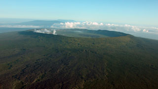
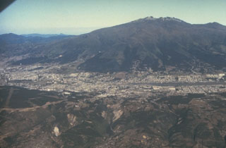
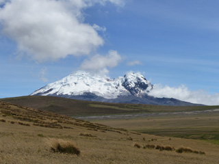
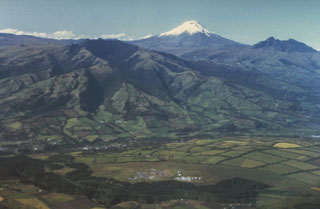 Snow-capped Cotopaxi volcano towers above the Interandean valley, forming one of Ecuador's most familiar landmarks. The older Pleistocene volcanoes of Pasochoa (left center) and Rumiñahui (extreme right) appear in the foreground of this aerial view from the NW. Cotopaxi is one of Ecuador's most active volcanoes, having erupted more than 50 times since the 16th century.
Photo by Minard Hall, 1980 (Escuela Politécnica Nacional, Quito).
 Tungurahua, a steep-sided stratovolcano that towers more than 3 km above its northern base, is one of Ecuador's most active volcanoes. Historical eruptions have frequently modified the morphology of the summit crater, which is now 300-m wide and 200-m deep. They have been accompanied by strong explosions and sometimes by pyroclastic flows and lava flows that reached populated areas at the volcano's base. The last major eruption began in 1916 and lasted until 1925.
Copyrighted photo by Katia and Maurice Krafft, 1983.
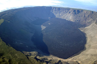
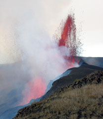 A 150-m-high lava fountain rises on October 23, 2005 from one of four active vents that define the active fracture system at the base of the northern inner wall of Sierra Negra's caldera. An eruption began on October 22, 2005 from a 2-km-long, roughly E-W-trending fissure vent along the north caldera rim, initially producing a 15-km-high eruption column. Some lava flows traveled down the north flank, but the bulk of the lava flows traveled into the caldera and followed its east wall before being deflected by the southern caldera wall to the west.
Photo by Minard Hall, 2005 (Escuela Politecnica Nacional, Quito).
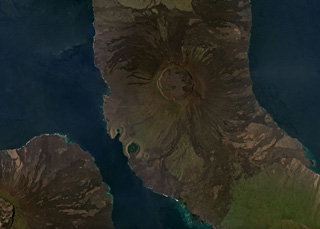
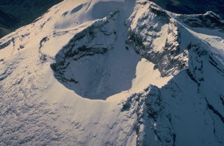
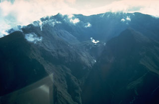
 The large 7-8 km wide summit caldera of Alcedo volcano is seen in this aerial view from the south. Alcedo is one of the lowest and smallest of six shield volcanoes on Isabela Island; Darwin and Wolf volcanoes can be seen in the background. Much of the flanks and summit caldera are vegetated, but young lava flows are prominent on the northern flank near the saddle with Darwin volcano, and an active hydrothermal system lies within the caldera.
 Photo by Patricio Ramon, 2005 (Instituto Geofisca, Escuela Politecnica Nacional).
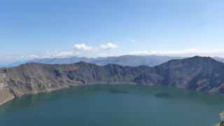 The Quilotoa caldera walls rise around 400 m above the lake, exposing the rocks that formed the previous edifice and intrusions that pushed through them. The high point to the right is the SE lava dome. Bathymetry suggests that several events formed the caldera, with an older and deeper western caldera.
Photo by Ailsa Naismith, 2015.
 A dark lava flow descends the upper western flank of Sangay volcano in 1976. The lava flow originated from the southernmost of several small craters at Sangay's summit. This frequently cloud-covered volcano is Ecuador's most active. Almost continuous minor explosive activity took place from 1728 until about 1916, and resumed in 1934. Occasional larger eruptions produced detonations heard hundreds of km away.
 Photo by Minard Hall, 1976 (Escuela Politécnica Nacional, Quito).
 A combination of frequent eruptions, a high water budget locked up in its summit icecap, and its location atop the topographic axis of the Ecuadorian Andes make Cotopaxi a prime source of lahars (volcanic mudflows). During historical time, lahars have swept drainages to the north along the Río Pita and Río Guayllabamba all the way to the Pacific Ocean and into the western Amazon basin down the Río Cutuchi to the SW and the Río Napo to the east. More than 130,000 people occupy areas subject to lahar risk from Cotopaxi.
Copyrighted photo by Katia and Maurice Krafft, 1983.
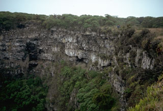 Lava flows line the steep walls of a pit crater on Santa Cruz island. Note the person standing on the rim at the right for scale. Pit craters are formed by collapse following the withdrawal of magma along a rift zone. They differ from other craters in that their rims lack a mantle of explosive debris. In some cases, vertical-walled pit craters can be hundreds of meters deep.
Photo by Lee Siebert, 1978 (Smithsonian Institution).
 The spatter cones at the right are part of a chain of conelets built of scoria and lava agglutinate erupted from a SW-flank radial fissure from Darwin volcano that cuts across the rim of Tagus tuff cone. Tagus tuff cone contains at least four nested craters. The rims of three of these craters are seen in the backgound. Phreatomagmatic eruptions, resulting from the interaction of magma with seawater, produced the tuff cones.
Photo by Lee Siebert, 1978 (Smithsonian Institution).
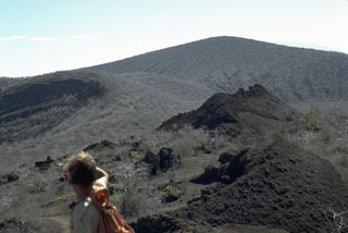
 An aerial view from the north looks across the 6 x 7 km wide summit caldera of Volcán Wolf. Fresh-looking, dark-colored lava flows, erupted from fissures on the eastern and western caldera walls, cover much of the caldera floor. At 1710 m, Wolf is the highest of the Isabella Island shield volcanoes.
Photo by Patricio Ramon, 2005 (Instituto Geofisca, Escuela Politecnica Nacional).
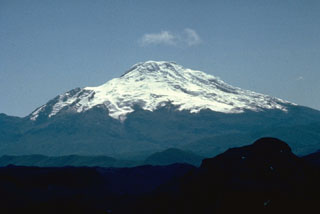 The massive compound Cayambe stratovolcano, seen here from the SW across Ecuador's Interandean Depression, is the northernmost of a chain of large, glacier-covered Holocene volcanoes along the western edge of the Cordillera Real. No historical eruptions are known from 5790-m-high Cayambe, although lava flows on the flanks of the volcano have very young morphologies. Pyroclastic-flow deposits of possible Holocene age are present.
Photo by Minard Hall, 1982 (Escuela Politécnica Nacional, Quito).
 Incandescent lava fountains and eruption column from Sierra Negra are seen from Cerro Dragon on Santa Cruz Island sometime after the onset of the eruption at about 1700 hrs on October 22, 2005. Satellite imagery indicated that the eruption plume reached at least 15 km altitude. The lava fountains were estimated to be about 200-300 m high.
Photo by Lucho Verdesoto, 2005.
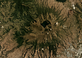
 The 5-km-diameter, 200-m-deep summit caldera of the Volcán Darwin is near the center of this March 2019 Planet Labs satellite image monthly mosaic (N is at the top). Lava flows on all flanks have erupted from circumferential and radial fissures around the flanks and into the caldera. The Beagle and Tagus tuff cones are along the SW coastline, with the northern Tagus Cone containing Tagus Cove. Fernandina is SW and the northern flanks of Alcedo are S; Volcán Darwin is out of view to the N.
Satellite image courtesy of Planet Labs Inc., 2019 (https://www.planet.com/).
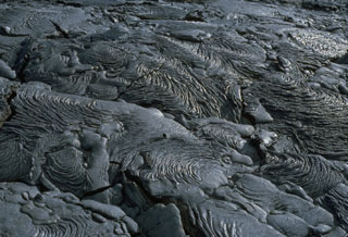 An extensive field of spectacular pahoehoe lava flows is located near Sullivan Bay on Santiago Island. The fresh, sparsely vegetated flows cover an area of more than 50 km2 along the SE coast of the island. Eruptions occurred at SE Santiago in 1897 and 1904-06. A small lava shield 3.5 km inland from Cabo Trenton on the SE tip of the island was the principal vent of these flows.
Photo by Lee Siebert, 1978 (Smithsonian Institution).
 The Fernandina shield volcano in the Galapagos Islands has a roughly 5 x 6 km summit caldera seen in this March 2019 Planet Labs satellite image monthly mosaic (N is at the top). Frequent eruptions often produce circumferential fissures near the caldera as well as fissures on the lower flanks that feed lava flows, many of which are visible in a radial pattern around the flanks. Lava flows and collapse events around the caldera walls modify the caldera floor, which has a lake at the time of this image acquisition.
Satellite image courtesy of Planet Labs Inc., 2019 (https://www.planet.com/).
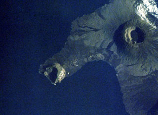
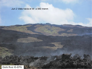 A view at Cerro Azul on June 2, 2008 looking west from 980 m elevation, shows lava flows from a May to June 2008 eruption. From May 29 to June 1, lava flows were emitted from fissures in the summit caldera and on the east flank. Beginning June 3, lava flows were erupted from fissures lower on the east flank. Eruptive activity from Cerro Azul decreased considerably during June 16-17 and on June 18 incandescent material was no longer ejected.
 Photo by Gorky Ruiz, 2008 (Instituto Geofisica, Quito).
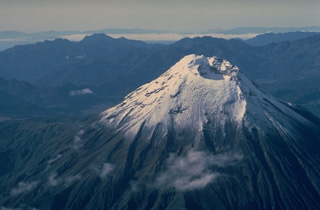
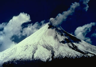
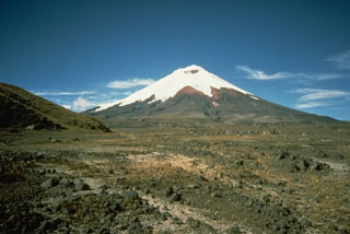
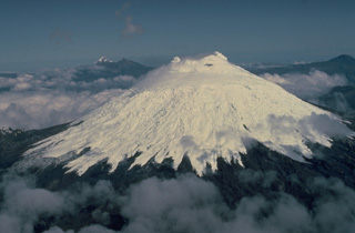 Glacier-clad Cotopaxi volcano is seen here from the SE, with twin-peaked Illiniza volcano in the distance left of the summit. Cotopaxi is one of Ecuador's most active volcanoes and has erupted more than 50 times since its first historical eruption in the 16th century. The upper 1400 m of the volcano is ice covered, which has contributed to the production of lahars that have devastated valleys far beyond the volcano.
Copyrighted photo by Katia and Maurice Krafft, 1983.
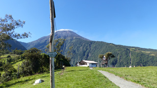 This 3 December 2015 photo shows the Volcán Tungurahua SSW flank from the Casa de Arbol, where IG-EPN operate a seismic station (Runtun). The station is managed by a member of the vigía network, which is a community based monitoring system of volunteers who observe nearby volcanoes and communicate activity to Tungurahua Volcano Observatory volcanologists and local officials. A weak degassing plume is dispersing to the right from the summit, which is also under a small meteorological cloud.
Photo by Ailsa Naismith, 2015.
 Imbabura volcano rises above the town of San Pablo del Lago in this aerial view from the south. The tip of Laguna de San Pablo is visible at the left. The main edifice, Taita Imbabura ("Father Imbabura"), forms the summit. Huarmi Imbabura ("Imbabura's Son") is a lateral lava-dome complex forming the grassy shoulder on the SW flank directly above the town of San Pablo del Lago in this view. Activity at the dominantly Pleistocene Imbabura volcano continued into at least the early Holocene.
Photo by Patricio Ramon (Instituto Geofisca, Escuela Politecnica Nacional).
 Activity seen in this August 1976 view of the west flank of Sangay volcano is typical of a long-term eruption that began in 1934. An ash plume rises from one of several summit craters. Much of the dark area on the western flank is a shadow, but a dark lava flow can be seen descending the slopes of the volcano. Frequent explosive eruptions and occasional lava flows have constructed Ecuador's most symmetrical volcano. It rises to over 5200-m altitude above the jungles of the western Amazon basin.
Photo by Jean-Christophe Sabroux, 1976 (courtesy of Minard Hall, Escuela Politécnica Nacional, Quito).
 The morphology of the summit crater of Tungurahua volcano, seen from the the NNW in 1983, has frequently been modified by powerful explosive eruptions duinng historical time. In 1873, the crater was 500-m wide and 80-m deep. In 1923, near the end of an eruption that began in 1916, the crater assumed its present dimensions of 300 m in width and 200 m in depth. The SE crater rim is 200 m higher than its NW rim.
Copyrighted photo by Katia and Maurice Krafft, 1983.
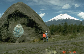 This massive boulder on the SW side of Cotopaxi was carried in a lahar, possibly during a major eruption in 1877. Scale is provided by volcanologists Minard Hall and Patty Mothes. More than 130,000 people live in areas subject to lahar risk from Cotopaxi. The 1877 eruption produced lahars that covered this valley, swept into eastern river drainages, and reached the Pacific Ocean along valleys to the NW.
Photo by Tom Pierson, 1992 (U.S. Geological Survey).
 The broad shield volcano forming Santa Cruz Island is seen from its northern coast. The oval-shaped, 32 x 40 km wide island is capped by cinder cones with well-preserved craters that largely bury a shallow summit caldera. The highland scoria cones are grouped along an E-W belt parallel to recent fault scarps that border Academy Bay, location of the Charles Darwin Research Station.
 Photo by Lee Siebert, 2006 (Smithsonian Institution).
 The smallest of at least four nested craters on Tagus tuff cone, located on the SW flank of Darwin volcano, is filled by a small lake. The ridge at the upper left is the SE rim of the tuff cone, which is breached by Tagus Cove, one of the most renowned anchorages in the Galápagos archipelago. Cerro Azul shield volcano rises in the distance at the southern end of Isabela Island.
 Photo by Lee Siebert, 1978 (Smithsonian Institution).
 Guagua Pichincha stratovolcano rises immediately to the west of Ecuador's capital city, Quito. A small lava dome is located at the head of a 6-km-wide breached caldera, which is out of view beyond the horizon in this photo. The caldera formed during a late-Pleistocene slope failure about 50,000 years ago. Many minor eruptions have occurred since the Spanish era; the volcano's largest historical eruption in 1660 deposited 30 cm of ash on Quito.
 Photo by Minard Hall, 1982 (Escuela Politécnica Nacional, Quito).
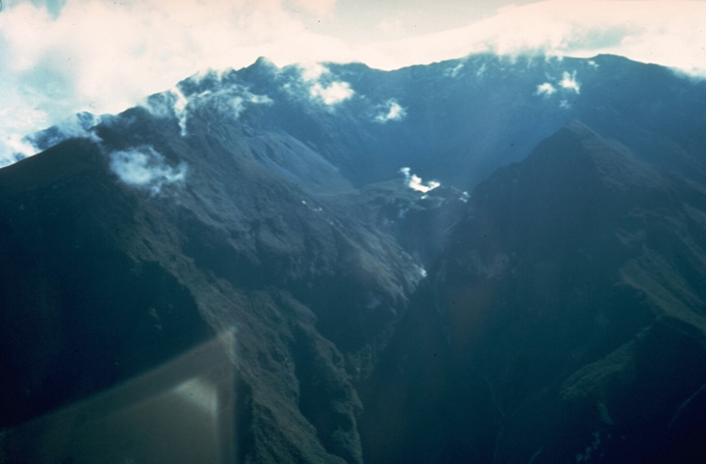
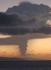
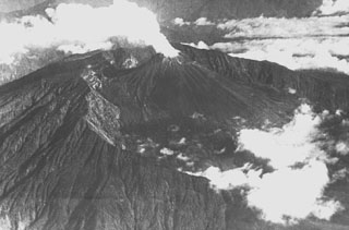
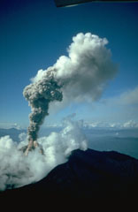 An ash column rises above the summit crater of Reventador volcano during the 1976 eruption. This view across the north caldera rim in the foreground shows a small pyroclastic flow descending the flank of the summit cone into the clouds. Pyroclastic flows began between the 2nd and 3rd weeks of the eruption, which started on January 1. They originated from collapse of the vertical eruption column and traveled down the flanks of the volcano onto the floor of the breached caldera. Pyroclastic-flow activity continued for several months.
Photo by Minard Hall, 1976 (Escuela Politécnica Nacional, Quito).
 Pululahua is a relatively low-profile, forested volcano immediately north of the equator, 27 km N of Quito. Loma Pondona (left) and the lower Rumiloma (right center) are two of a group of lava domes that partially fill a 3-km-wide caldera. They are seen here from the SE caldera rim. The caldera was formed during the latest dated eruption about 2,400 years ago. Large explosive eruptions were accompanied by pyroclastic flows during the late Pleistocene and Holocene.
Photo by Lee Siebert, 1978 (Smithsonian Institution).
 A large tuff cone rises near Punta Calle on the southern coast of Marchena Island beyond fresh-looking lava flows west of the cone in the foreground. The low shield volcano forming Marchena Island contains one of the largest calderas of the Galápagos Islands. In contrast to other Galápagos volcanoes, the 6 x 7 km caldera and its outer flanks have been largely buried by a cluster of pyroclastic cones and associated lava flows. The first historical eruption of Marchena occurred in 1991.
 Photo by Ed Vicenzi, 1984 (Smithsonian Institution).
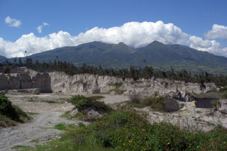 Part of the Chachimbiro volcanic complex, located about 25 km NW of the city of Ibarra, is seen from the south. The late Pleistocene-to-Holocene, NNE-trending dacitic Chachimbiro-Pucará line of lava domes includes the Pitzantzi lava dome, which erupted about 5700 years ago, producing an ash deposit that extends to the NW. Hot springs and thermal areas are present at the Chachimbiro complex. Quarries in the foreground are cut into deposits from the caldera-forming eruption of Cuicocha volcano.
 Photo by Lee Siebert, 2006 (Smithsonian Institution).
 The isolated Sangay volcano towers above tropical jungles east of the Andean crest. Seen here from the NE, it is one of Ecuador's most active volcanoes and has been in frequent eruption during the past several centuries. The steep-sided, glacier-covered volcano has been constructed within the older Verdeloma somma to the south. Historical eruptions were first reported in 1628. More-or-less continuous eruptions took place from 1728 until 1916, and again from 1934 until the present.
 Photo by Minard Hall, 1976 (Escuela Politécnica Nacional, Quito).
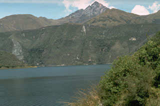 Sharp-peaked Cotacachi stratovolcano rises above the caldera lake of Cuicocha volcano. The northern caldera wall truncates the flank of the heavily eroded Cotacachi. The caldera was formed during powerful explosive eruptions about 3100 years ago that produced 4.8 cu km of pumice-rich pyroclastic flows and airfall tephra that blanket the surrounding countryside.
Photo by Tom Pierson, 1992 (U.S. Geological Survey).
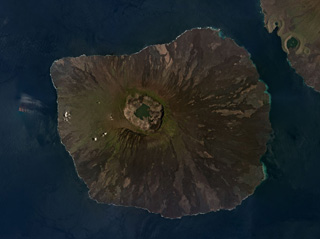
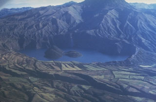
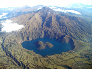 The scenic lake-filled Cuicocha caldera is located at the southern foot of the sharp-peaked Pleistocene Cotacachi stratovolcano (top center) about 100 km north of Quito. Farmer's fields encroach on the rim of the 3-km-wide caldera, which was created during a major explosive eruption about 3100 years ago. Dacitic lava domes form two forested islands in the caldera lake. Pyroclastic-flow deposits from the caldera-forming eruptions cover wide areas in now populated areas below the low-rimmed caldera.
 Photo by Patricio Ramon, 2003 (Instituto Geofisca, Escuela Politecnica Nacional).
 A dramatic sinuous N-S-trending ridge extends across the western side of the summit caldera of Sierra Negra volcano, forming the border of a graben lying between it and the caldera wall to the left. Volcán Azufre, the largest fumarolic area in the Galápagos Islands, is located in this part of the 7 x 10.5 km wide caldera. An arcuate line of small vents parallel to the caldera wall were produced by eruptions from circumferential fissures parallel to the caldera walls and fed lava flows that primarily traveled down the outer flanks of the volcano.
Photo by U.S. Air Force, 1946
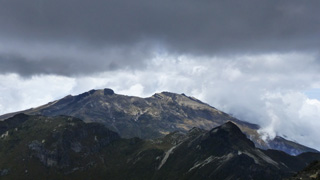 This October 2015 view is from the summit of Rucu Pichincha (“Old Man Pichincha” in the indigenous Quechua language) facing west towards the Guagua Pichincha (“Baby Pichincha”) vent. Eruptions have produced ashfall that has impacted Quito, 14 km W. The recently active vent is situated within a landslide scarp that opens towards the SW, and an older landslide scarp is on the western flank.
Photo by Ailsa Naismith, 2015.
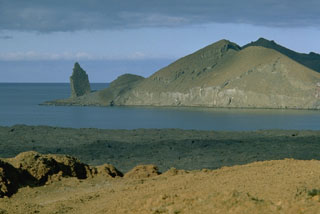 A spectacular suite of volcanic features flanks Sullivan Bay, at the eastern end of Santiago Island. This view looks NE across the bay to Bartolomé Island. The sharp pinnacle at the left, a remnant of an eroded tuff cone, is one of the many scenic highlights of the Galápagos Islands. Bartolomé Island contains eroded tuff cones, a dissected solidified lava lake, and a youthful lava plateau. The flat coastline of Santiago Island in the foreground is formed from a vast field of youthful pahoehoe lava flows that wraps around the SE corner of the island.
Photo by Lee Siebert, 1978 (Smithsonian Institution).
 Illiniza Sur is the older of the two peaks that form the Illiniza complex. This November 2015 view from the NE shows some of the stratigraphy exposed by extensive erosion.
Photo by Ailsa Naismith, 2015.
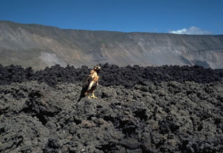 A Galápagos hawk perches on a blocky lava flow erupted in Fernandina caldera in 1978, inspecting some of the infrequent visitors to the caldera floor of this uninhabited island volcano. These August 1978 lava flows descended from the NW caldera bench over a broad, 1-km-wide front into the caldera lake. The NE rim in the background rises over 800 m above this part of the floor of the 4.5 x 6 km caldera.
Photo by Lee Siebert, 1978 (Smithsonian Institution).
 Fumaroles rise above a small crater (right center) at the base of the headwall of the 6-km-wide summit caldera of Guagua Pichincha volcano. The breached caldera seen here from the east was formed about 50,000 years ago. Subsequent late-Pleistocene and Holocene eruptions from the central vent in the breached caldera consisted of explosive activity with pyroclastic flows that accompanied periodic growth and destruction of a lava dome.
 Photo by Minard Hall, 1975 (Escuela Politécnica Nacional, Quito).
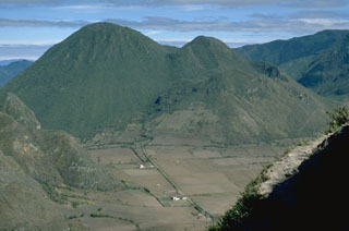
 Mojanda volcano has a 3-km-wide caldera that contains the Laguna Grande de Mojanda, shown in this August 2019 Planet Labs satellite image monthly mosaic (N is at the top; this image is approximately 24 km across). The complex contains the older Fuya Fuya to the W, and Mojanda to the E. Fuya Fuya underwent a large flank collapse that produced the horseshoe-shaped scarp on the SW side, opening towards the W. The Cerro el Panecillo dome is on the NW flank.
Satellite image courtesy of Planet Labs Inc., 2019 (https://www.planet.com/).
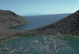
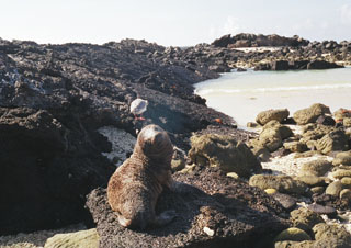 A sea lion perches on a tilted slab of a lava flow dipping toward the west side of Darwin Bay. A 2-km-wide excentric caldera on the south side of Genovesa Island forms an embayment that is filled by the bay. The small, very low island of Genovesa is the top of a shield volcano, whose summit is only 64 m high. No historical eruptions are known from Genovesa, although the fresh-looking lava flows suggest a very youthful age.
 Photo by Carter Hearn, 2004.
 The foreground of this flat valley north of Cotopaxi volcano is the top of the deposit produced by a massive lahar from the volcano in 1877. During this eruption, one of the largest from Cotopaxi during historical time, pyroclastic flows descended all sides of the volcano, creating devastating lahars. The lahar that produced this deposit eventually traveled north down the Guayllabamba River past Quito to reach the Pacific Ocean at Esmeraldas, 225 km NW of Cotopaxi. Mudflows also swept down valleys south and east into the western Amazon basin.
Photo by John Ewert, 1987 (U.S. Geological Survey).
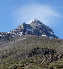
 Volcán Antisana is seen here looking NE from highway E20 in December 2015. Northeast Peak is to the right and the East Ridge is to the left, with a collapse scarp between them.
Photo by Ailsa Naismith, 2015.
 Volcán Ecuador (left center) forms the tip of a peninsula straddling the equator at the NW end of Isabela Island. The western side of the volcano, the smallest of the six large shield volcanoes on Isabela, is breached nearly to sea level. A line of fissure-fed vents on the outer eastern flank can be seen connecting Volcán Ecuador with Volcán Wolf (upper right). Despite the absence of historical eruptions from Volcán Ecuador, the youthful morphology of its most recent lava flows resembles those of very recent flows on other Isabela Island volcanoes.
NASA Space Shuttle image S-27-42-018, 1984 (http://eol.jsc.nasa.gov/).
 Scenic lake-filled Cuicocha caldera is located at the southern foot of the sharp-peaked Pleistocene Cotacachi stratovolcano. The caldera was created about 3100 years ago and contains a cluster of intra-caldera dacitic lava domes that form two islands in the large lake. A pre-caldera Cuicocha lava dome is situated on the east side of the lake (right). Pyroclastic-flow deposits cover wide areas around the volcano. The northern caldera rim truncates the heavily eroded slopes of Cotocachi volcano.
 Photo by Minard Hall, 1985 (Escuela Politécnica Nacional, Quito).
 A steam plume, seen in a 1944 aerial view from the SE, rises above the summit crater of Reventador volcano. An eruption during February 24 to March 1, 1944 caused ashfall in the Andes and produced a lava flow down the Río Ouijos. The steaming El Reventador stratovolcano is nestled within the rim of an arcuate caldera that is breached widely to the east. It rises 1300 m above the caldera floor and is one of Ecuador's most active volcanoes.
Photo courtesy of Minard Hall (Escuela Politécnica Nacional, Quito), 1944.
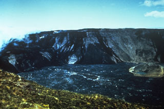 A 1966 photo from the NE caldera rim shows the effects of an eruption in 1958. A major effusive eruption from vents on the SE, SW, and west caldera rims produced lava flows that descended the SE and SW flanks and also flowed into the caldera, completely covering the caldera floor. One report suggested that the eruption was underway during a September-October 1958 visit; the eruption was in waning stages on a December 30, 1958 visit. At this time, prior to additional collapse in 1968, the caldera was 800 m deep.
Photo by Alan Root, 1966 (courtesy of Tom Simkin, Smithsonian Institution).
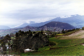 Cerro Tulabug (right-center), part of the Licto group of basaltic andesite to andesitic scoria cones, is seen here from the SW. The cones lie along the Río Chambo about 25 km SE of the city of Riobamba and just north of the town of Licto and form the southernmost area of Quaternary volcanism in the Interandean valley of Ecuador. The cloud-draped conical volcano in the left-center background is Reventador, and the Cordillera Real forms the right horizon.
Photo by Patricio Ramon, 1998 (Instituto Geofisca, Escuela Politecnica Nacional).
 Dust clouds rise from Fernandina caldera on July 4, 1968, about three weeks after a major explosive eruption that was followed by collapse of the caldera floor. Collapse occurred incrementally and asymmetrically, ranging up to about 350 m at the SE end of the caldera, which contains the caldera lake. Fernandina, the most active of Galápagos volcanoes, is a basaltic shield volcano with a deep 4 x 6.5 km summit caldera. Flat-topped benches mark the SE and NW ends of the elliptical caldera.
Photo by Tom Simkin, 1968 (Smithsonian Institution).
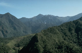 Atacazo stratovolcano, located 20 km south of Quito, is seen here from the west along the road to Guayaquil. The volcano contains a summit caldera that is partially filled by lava domes of Holocene age. Lava domes are also found on the SE flank. The only dated Holocene eruption took place about 2400 years ago, forming the Ninahuilca lava domes, the peaks below the center horizon.
 Photo by John Ewert, 1992 (U.S. Geological Survey).
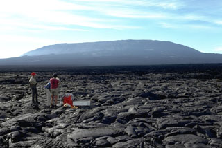 Fernandina volcano in the Galápagos exhibits steep upper flanks formed by eruptions of lava flows from circumferential fissures around a summit caldera rim, contrasting with the broad, low-angle lower flanks. Scientists from the Smithsonian Institution, U.S. Geological Survey, and the Charles Darwin Research Station conduct measurements on a pahoehoe lava flow near the SE coast. Young, unvegetated lava flows cover the flanks.
Photo by Chuck Wood, 1978 (Smithsonian Institution).
 A steam-and-gas plume rises from the central cone of Reventador volcano in this March 11, 2005 aerial view from the SE. Several lava flows generated during eruptions in 2002 and 2004-2005 are visible on the south and SE flanks of the central cone. The 3562-m-high central cone was constructed within the large 4-km-wide horseshoe-shaped caldera breached to the east (lower right). The caldera was formed during a major collapse of the volcano, which produced a massive debris avalanche that swept into the Amazon basin.
Photo by Patricio Ramon, 2005 (Instituto Geofisca, Escuela Politecnica Nacional).
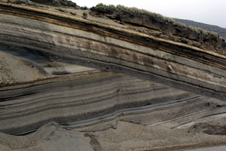 An erosional unconformity cutting diagonally across the center of the photo due to a glacial advance about 20,000-18,000 years ago separates two sequences of late-Pleistocene tephra layers from Ecuador's Chimborazo volcano. A less prominent unconformity below the light-colored tephra layer at the top of the sequence marks a 16,000-14,000 year old glacial advance. This ~12-m-thick exposure lies on the SW flank.
Photo by Lee Siebert, 2006 (Smithsonian Institution).
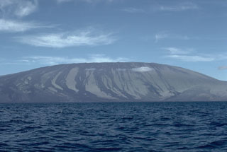 Wolf, the highest volcano of the Galápagos Islands, is located near the equator at the N end of the archipelago's largest island, Isabela. The summit caldera is 5.5 x 7 km and 600 m deep, with recent lava flows covering the broad caldera floor. Prominent unvegetated lava flows are visible on the flanks to the sea. Wolf's 1797 eruption was the first documented in the Galápagos Islands.
Photo by Lee Siebert, 1978 (Smithsonian Institution).
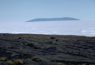 The broad shield volcano of Sierra Negra at the southern end of Isabela Island rises above a sea of clouds across from the tephra-mantled caldera rim of Fernandina volcano. Sierra Negra is the largest, but lowest-angle shield volcano on Isabela. The summit of the volcano contains a shallow 7 x 10.5 km caldera that is the largest of the Galápagos Islands. Sierra Negra is one of the most active of the Isabela Island volcanoes.
 Photo by Lee Siebert, 1978 (Smithsonian Institution).
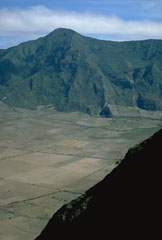 The flat floor of the 3-km-wide caldera of Pululagua volcano is used for agricultural purposes. This view from the SE caldera rim looks across to Loma El Lavadero on the NE rim, 700 m above the caldera floor. Pululagua's caldera was formed during major explosive eruptions about 2400 years ago that produced plinian airfall deposits, pyroclastic flows, and pyroclastic surges.
Photo by Lee Siebert, 1978 (Smithsonian Institution).
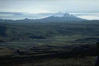 Massive, 5753-m-high Antisana volcano is seen here from its SW on the northern flank of Cotopaxi volcano. The glacier-clad Antisana was constructed immediately SE of Chacana caldera, the largest rhyolitic center of the northern Andes, which lies beyond the jagged ridge left of Antisana. The only unequivocal historical eruption of Antisana occurred in 1801-02 from a vent NNE of the summit.
 Photo by John Ewert, 1992 (U.S. Geological Survey).
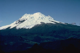 Antisana volcano is one of four massive glacier-covered stratovolcanoes constructed along a N-S line at the western edge of Ecuador's Cordillera Real. Its summit crater is breached to the SE, behind the summit in this view from the NW. Its only unequivocal historical eruption produced a lava flow from a NNE-flank vent at the beginning of the 19th century.
Photo by Minard Hall, 1979 (Escuela Politécnica Nacional, Quito).
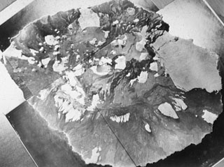 The low shield volcano forming Marchena Island contains one of the largest calderas of the Galápagos Islands. A group of pyroclastic cones was constructed inside the caldera. Lava flows originating from the 6 x 7 km wide caldera have spilled through low points on the caldera rim and flowed down the flanks of the volcano, in some cases reaching the sea. The first historical eruption of Marchena occurred in 1991.
 Aerial photos by Instituto Geográfico Militar (courtesy of Minard Hall).
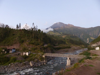 The NE flank of Tungurahua is seen here on 4 December 2015 from the town of Palictahua, near the Iglesia Católica de Cristo del Consuelo. Lahars at Tungurahua frequently travel large distances and occasionally cause road closures around the volcano. The foreground shows a large concrete block in front of the existing bridge that may be remains of an older damaged structure.
Photo by Ailsa Naismith, 2015.
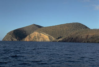 Cabo Cowan is a tuff cone at the NW tip of Santiago Island in the Galápagos Islands. Wave erosion has truncated the flanks of the cone, forming vertical sea cliffs that expose its interior stratigraphy. The cone is located where the NW-trending rift zone along the crest of Santiago shield volcano encounters the sea.
Photo by Lee Siebert, 1978 (Smithsonian Institution).
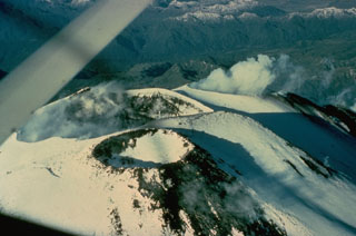 Steam clouds rise above two of three summit craters at Ecuador's Sangay volcano. Continual eruptions since 1934 have frequently modified the morphology of the volcano's summit. At the time of this 1976 view from the east, a lava flow from the southernmost crater (right) was descending the western flank.
Photo by Gordon Armstrong, 1976 (courtesy of Minard Hall, Escuela Politécnica Nacional, Quito).
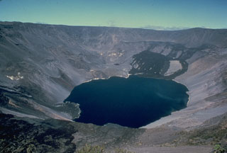 Fernandina, the most active of Galápagos volcanoes, is a basaltic shield volcano with a deep 4 x 6.5 km summit caldera. This 1978 photo shows dark lava flows at the far NW end that were erupted from the NW caldera bench in August 1978. The lava delta at the lower left was formed by lava flows down the west side of the SE bench in 1977. In 1968 the caldera floor dropped 350 m following a major explosive eruption. Collapse of part of the east caldera wall during a 1988 eruption produced a debris-avalanche deposit that absorbed the caldera lake.
Photo by Chuck Wood, 1978 (Smithsonian Institution).
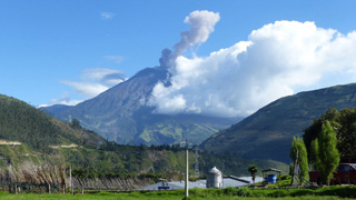 This 21 October 2015 photo shows an ash plume rising from Tungurahua, seen from the Observatorio del Volcán Tungurahua (OVT) to the NNW, near the village of Patate, operated by the Instituto Geofisico de la Escuela Politecnico Nacional (IG-EPN). Activity in 2015 was characterized by frequent ash and gas emissions and a variety of seismicity, including volcano-tectonic and long-period events.
Photo by Ailsa Naismith, 2015.
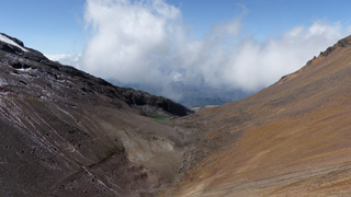 A small lake is seen here between the two peaks of Illiniza, with the flank of Illiniza Norte to the right and Illiniza Sur to the left.
Photo by Ailsa Naismith, 2015.
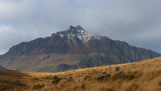 Illiniza Norte is the shorter and older of the two peaks that form the Illiniza complex in Ecuador, with Illiniza Sur out of view to the left. The substantially eroded peak is seen here from the NE in November 2015, approaching from the Interandean Valley.
Photo by Ailsa Naismith, 2015.
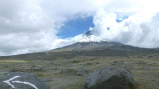 An eruption at Volcán Cotopaxi began on 14 August 2015 with a series of phreatic explosions in the crater, seen here from the N in December 2015 with ash deposits across the summit area. Explosive activity continued throughout August with continuous ash-and-gas emissions that declined towards the end of September 2015. Degassing at the summit produces the plume rises towards the towards the NW.
Photo by Ailsa Naismith, 2015.
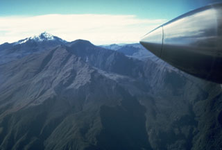 The summit of Cerro Negro de Mayasquer volcano is truncated by a caldera that is breached to the west. This view from the NW shows snow-capped Volcán Chiles at the upper left. Eruptive activity at these twin volcanoes has migrated to the west, with the most recent eruptions occurring from Cerro Negro de Mayasquer. A small crater lake is found at the bottom of the 900 x 1500-m-wide caldera. An eruption that was reported from the volcano in 1936 may actually have been from Reventador volcano to the SE.
Photo by Minard Hall, 1985 (Escuela Politécnica Nacional, Quito)
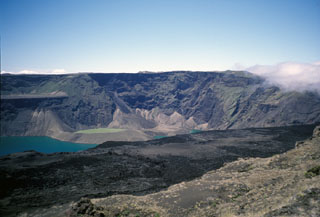 A view from the west caldera rim of Cerro Azul shows a caldera bench covered with young lava flows in the foreground and part of the blue caldera floor lake and a tuff cone filled with greenish lake water. The photo was taken in July 1998, shortly before an eruption in September 1998 from vents on the south caldera bench and the west caldera floor.
Photo by Michael Lang, 1998 (Smithsonian Institution).
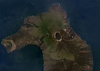 The 700-m-deep summit caldera of the Volcán Wolf shield volcano on Isabela Island, Galapagos Islands, is near the center of this March 2019 Planet Labs satellite image monthly mosaic (N is at the top; this image is approximately 50 km across). Lava flows have erupted from radial and circumferential fissures from the summit to the lower flanks. Volcán Ecuador and its East Rift zone forms the western peninsula, and the northern flank of Volcán Darwin is to the south.
Satellite image courtesy of Planet Labs Inc., 2019 (https://www.planet.com/).
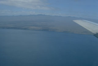 The highlands of the broad Santa Cruz shield volcano, seen here from the NE, are capped by youthful cinder cones with well-preserved craters. The scoria cones are grouped in an E-W belt parallel to recent fault scarps that border Academy Bay and largely bury a shallow summit caldera. Older uplifted submarine lava flows are found on the NE part of the island and at the fault-delimited offshore island of Baltra. No historical eruptions are known from Santa Cruz, the 2nd-most populated island of the Galápagos archipelago.
Photo by Lee Siebert, 1978 (Smithsonian Institution).
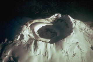 The glacier-capped summit of Ecuador's Cotopaxi volcano has two nested summit craters. The outer crater, seen here from the SE, is 550 x 800 m wide. A cone that grew inside this crater contains a smaller crater that is 250 m wide and 120 m deep. Frequent explosive eruptions during historical time have modified the shape of the summit crater. In 1903 the outer crater was 450 m deep.
Photo by Tom Simkin (Smithsonian Institution).
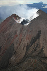 The steaming summit crater of Reventador volcano in northern Ecuador is seen in this aerial view from the north on April 21, 2005. The black area in the center of the crater is a new lava dome that began growing inside the crater during an eruption that had begun in November 2004. Lava flows from the crater periodically descended a notch in the far crater wall and flowed down the southern flank of the cone. Conical Sumaco volcano is seen in the background.
Photo by Patricio Ramon, 2005 (Instituto Geofisca, Escuela Politecnica Nacional).
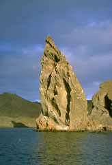 This prominent pinnacle is an eroded remnant of a tuff cone on Bartolomé Island, off the east coast of Santiago Island. A wide variety of volcanic features flanks Sullivan Bay, one of the most visited boat anchorages in the Galápagos Islands. These include tuff cones and cinder cones, a dissected solidifed lava lake, and vast fields of youthful pahoehoe lava flows.
Photo by Lee Siebert, 1978 (Smithsonian Institution).
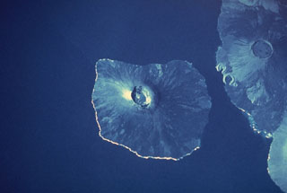 Two massive Galápagos shield volcanoes, their slopes darkened by young unvegetated lava flows that reach to the sea, appear in this space-shuttle photograph. Fernandina volcano, the most active in the Galápagos Islands, forms a 30 x 34 km wide island with a 4 x 6.5 km wide caldera at its summit. Darwin volcano, north of the midpoint of Isabela Island, has a 5-km-wide summit caldera. The tuff cones of Tagus and Beagle are prominent along its western coast. The light-colored area south of Darwin is the lower western flank of Alcedo volcano.
NASA Space Shuttle image, 1989 (http://eol.jsc.nasa.gov/).
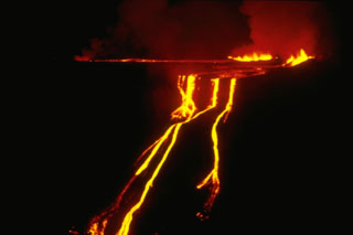 A fissure eruption on the SE caldera bench of Fernandina volcano feeds lava flows that form a spectacular, 530-m-high cascade of molten lava down the caldera wall. A four-day-long eruption began on March 23, 1977 from fissures on the west side of the SE caldera bench, 300 m below the caldera rim. Lava flows can be seen spreading out over the caldera bench before pouring over the caldera wall. The distal end of the lava flows formed a small lava delta in the 2-km-wide caldera lake.
 Photo by Dagmar Werner, Charles Darwin Research Station, 1977 (courtesy of Tom Simkin, Smithsonian Institution).
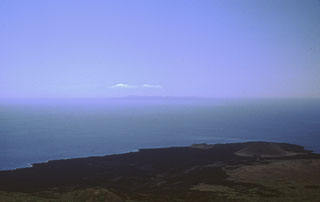 The elongated island of Pinta is the northernmost of the active Galápagos volcanoes. This view from the summit of Pinta looks down on pyroclastic cones and lava flows on the southern flank of the shield volcano. Numerous young cones and lava flows originated from NNW-trending fissures cutting the island. The fresh, unvegetated lava flows that cover the SE and northern flanks appear to have been erupted during the past few thousand or few hundred years. The island in the distance is Marchena volcano.
Photo by Andrew Cullen, 1984 (University of Oregon, courtesy of Ed Vicenzi, Smithsonian Institution)
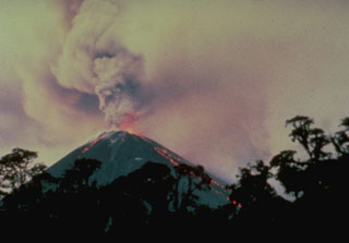 The 1976 eruption of Reventador volcano began on January 4 with explosions that sent ash west over the Amazonian jungle. At the same time lava flows from the summit crater descended the eastern flank of the cone. They split into several lobes and reached a length of 3 km before stopping at the end of the 3rd week of the eruption. Pyroclastic flows began between the 2nd and 3rd weeks and continued for several months, traveling at speeds up to 135 km/hr across the caldera floor. The eruption ended in May.
Photo courtesy of Minard Hall (Escuela Politécnica Nacional, Quito), 1976.
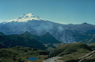 The floor of the massive Chacana caldera is seen here in the foreground, looking SE with glacier-covered Antisana volcano in the distance. Chacana is a 32 x 24 km caldera complex of Pliocene-Holocene age. Its outer flanks extend over 50 km, making it one of the largest rhyolitic centers of the northern Andes. Numerous lava domes were constructed within the caldera, which has been the source of frequent Holocene explosive eruptions. Dacitic lava flows were erupted during the 18th century and numerous hot springs are found on the caldera floor.
Photo by Minard Hall, 1976 (Escuela Politécnica Nacional, Quito).
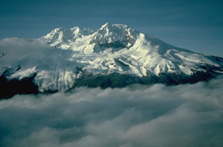 Antisana is a massive, glacier-covered stratovolcano NE of Cotopaxi. The 1.4 x 1.8 km summit crater, seen here from the north, is breached to the SE. Viscous, youthful block lava flows have issued from radial fissures on the flanks of 5753-m-high Antisana. The only unequivocal historical eruption took place from 1801 to 1802. Eighteenth-century eruptions occurred NW of Antisana within Chacana caldera, which lies beneath the cloud bank in the foreground.
Photo by Minard Hall, 1975 (Escuela Politécnica Nacional, Quito).
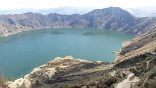 The 3-km-wide Quilotoa caldera resulted from several collapse events and contains a turquoise lake approximately 250 m deep. Intrusions and lava domes are exposed within the crater walls, with the largest being 1.3 km diameter and 400 m high in the ESE wall visible on the far side of this 2015 photo. Behind the caldera rim is the Interandean Valley.
Photo by Ailsa Naismith, 2015.
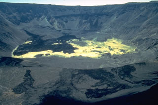 The light-colored lake sediments on the caldera floor are partially overlain by deposits of a massive debris avalanche produced when the east caldera wall collapsed on September 14, 1988. The debris avalanche swept into the caldera lake, displacing it and initially raising its level over 100 m. Lava flows from vents at about 750 m on the inner east wall were erupted through and onto the surface of the avalanche deposit on September 14-16, forming the dark areas at the left. By the time of this January 1989 photo the lake had been largely absorbed within the avalanche deposit.
Photo by Minard Hall, 1989 (Escuela Politécnica Nacional, Quito).
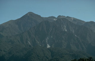 The Ninahuilca lava domes, which form the twin forested peaks below the right-center horizon, were created during an eruption about 2400 years ago. Growth of the lava domes within the summit caldera of Atacazo volcano was accompanied by plinian explosive eruptions and pyroclastic flows that traveled 35 km down valleys to the west.
 Photo by John Ewert, 1992 (U.S. Geological Survey).
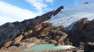 This December 2015 photograph shows the western flank of Volcán Cayambe with a small glacial lake (about 2 km down the SW flank), just above the Refugio Ruales Oleas Bergé. The presence of an ice cap at its summit represents a significant hazard, because melting of the ice by even small eruptions could generate large-volume lahars or debris flows.
Photo by Ailsa Naismith, 2015.
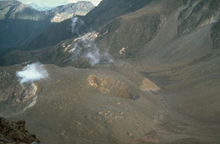 The small crater in the center of the photo was formed during phreatic eruptions in 1981-82 that blasted a hole on the NE side of the lava dome filling the summit caldera of Guagua Pichincha volcano. The first explosions in late August or early September 1981 were followed by others that by May 1982 had merged three small craters into a larger 50-m wide crater. A month later the crater had grown to the 100-m-wide size seen in this 1988 photo. The eruption lasted until late 1982.
Photo by Norm Banks, 1988 (U.S. Geological Survey).
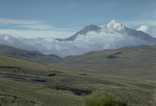 The twin peaks of Illiniza volcano form prominent landmarks west of the Interandean Valley. Sharp-peaked, snow-covered Illiniza Sur (right) is the higher of the two peaks. It is seen here from the south with Illiniza Norte to its left. Illiniza is largely, if not entirely Pleistocene in age. However, Rasuyacu lava dome on the south flank was active during the Holocene. Recent work suggests that Illiniza itself, which is substantially eroded, may have had relatively young eruptions.
Photo by Lee Siebert, 1978 (Smithsonian Institution).
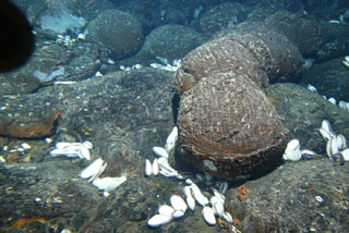 Submarine eruptions at mid-ocean ridges produce pillow lavas, which form as lava slowly erupts from a fissure on the sea floor. The E-W-trending Galápagos Rift located north of the Galápagos Islands is an oceanic spreading ridge between the Cocos plate to the north and the Nazca plate to the south. A large area of hydrothermal vents along the crest of the ridge ENE of the Galápagos Islands was discovered in 1977, along with evidence of a recent eruption.
 Image courtesy of NOAA Ocean Explorer, Woods Hole Oceanographic Institution.
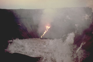 Streams of incandescent lava descend into the steaming caldera lake of Fernandina volcano in December 1973. This was one of several eruptions during the 1970's that produced lava flows from vents on caldera benches that spilled into the caldera lake. This eruption began on December 9 from vents 220 m below the east end of the SE bench, producing lava flows that formed a small lava delta in the lake. Glow was no longer visible the night of December 15, and ground observation on December 17 confirmed that the eruption had ceased.
 Photo by Mike Harris, 1973 (courtesy of Tom Simkin, Smithsonian Institution).
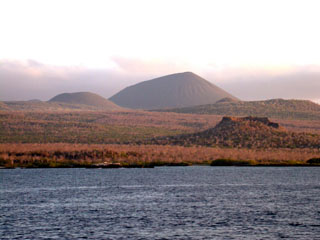 Floreana Island (also known as Charles Island or Santa María Island) is a broad shield volcano whose surface is densely covered with cinder cones. The most conspicuous of these is Cerro de Pajas, seen here from the north with a spatter cone in the right foreground. A massive pahoehoe lava flow from Cerro de Pajas, perhaps the youngest on Floreana, reached the SW coast over a broad 6.5 km area. The youngest lava flow on Floreana, once thought to be Holocene, has a late Pleistocene surface exposure age.
Photo by Ed Vicenzi, 2002 (Smithsonian Institution).
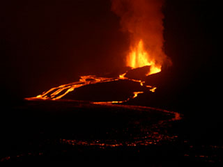 Lava fountaining of the Sierra Negra eruption is viewed from the east caldera rim on the night of October 24, the 3rd day of the eruption. Vigorous lava fountains rise from several locations along the fissure vent, feeding several anastomosing lava flows that poured into the caldera. The scattered glow in the foreground was due to ponded lava covering the caldera's eastern floor.
Photo by Gregg Estes, 2005.
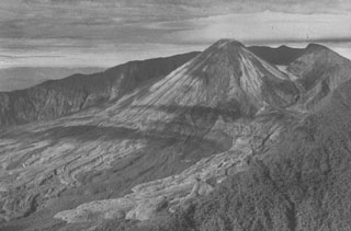 The remote and inaccessible Reventador volcano rises above the jungles of the western Amazon basin. El Reventador, a young stratovolcano constructed within the 3-km-wide breached caldera of Volcán Reventador, is the most frequently active of a N-S chain of Ecuadorian volcanoes that lies well east of the principal volcanic axis. Fresh-looking lava flows descending from El Reventador extend east across the caldera floor in this late-1960s photo. Explosive eruptions during historical time have been visible from Quito.
 Photo by Juan Elizalde (courtesy of Minard Hall, Escuela Politécnica Nacional, Quito).
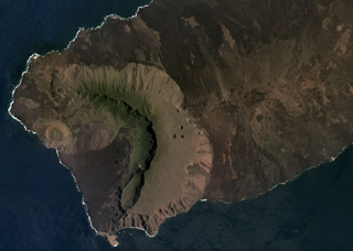 The western side of Volcán Ecuador has formed through caldera collapse and subsequent flank collapse, producing the caldera that opens towards the ocean in this March 2019 Planet Labs satellite image monthly mosaic (N is at the top; this image is approximately 13 km across). Within the caldera is the Cerro Grande tuff cone along the coast, a slump block along the SE caldera wall, and lava flows, as well as smaller vents. The East Rift is to the right in this image, towards Volcán Wolf out of view.
Satellite image courtesy of Planet Labs Inc., 2019 (https://www.planet.com/).
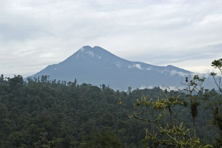 Forested Sumaco volcano rises to 3990 m above the jungles of the western Amazon basin and is seen here in an unusually cloud-free view NE of the road from Baeza to Tena. Sumaco is part of a north-south-trending volcanic chain far to the east of the main Andes volcanic axis and has erupted more alkaline rocks distinct from those of the main chain. Reports of historical eruptions are somewhat ambiguous, although the volcano maintains its symmetrical shape despite heavy rainfall and intense erosion.
Photo by Ursy Potter, 2005.
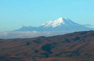 Glacier-clad, 6310-m-high Chimborazo is Ecuador's highest volcano. It is seen here from the NE with Carihuairazo volcano forming the lower, mostly snow-free peak to the left. The youngest and westernmost of three edifices constructed along an E-W line forms the current summit of Chimborazo. Although activity was once thought to have ceased during the very latest Pleistocene, recent work indicates that Chimborazo erupted several times during the Holocene.
Photo by Patricio Ramon, 2004 (Instituto Geofisca, Escuela Politecnica Nacional).
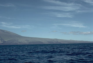 A radial fissure on the NE flank of Volcán Wolf has produced extensive lava flows that in part lap onto the flanks of the main shield volcano. A sharp break in slope separates the low-angle flank rift zone, whose smooth profile is interrupted by a few small cinder cones, from the upper shield volcano, which has some of the steepest slopes of Galápagos shield volcanoes. A fresh unvegetated lava flow from the main shield at the extreme left was deflected to the south by the lava produced from the NE rift.
Photo by Lee Siebert, 1978 (Smithsonian Institution).
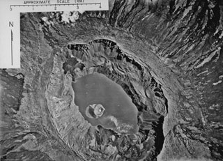 An aerial photograph mosaic shows Fernandina caldera from above in 1947. Concentric rows of circumferential fissures that are prominent along the caldera rim fed dark lava flows down the outer flanks of the volcano. The caldera lake that surrounds a prominent tuff cone was destroyed by lava flows during an eruption in 1958, but had reappeared prior to caldera collapse in 1968. During the 1968 collapse, the caldera floor dropped 350 m. The tuff cone rode the slow, piecemeal collapse downward without fragmenting.
 Photo by U.S. Air Force, 1947 (published in Simkin and Howard, 1971).
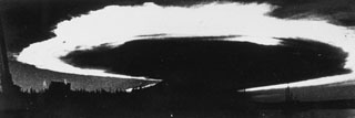 Caldera collapse in 1968 at the basaltic shield volcano, Fernandina, was preceded by lava effusion on the SE flank and a major explosive eruption on 11 June. The ash plume, seen here from Academy Bay on Santa Cruz Island within minutes of the explosion, is backlit by the late afternoon sun and was spreading at an estimated lateral speed of 80 km per hour. At the time of this photograph the ash plume was 175 km across with an altitude of 20-25 km.
Photo by J. Harte, 1968 (published in Simkin and Howard, 1970).
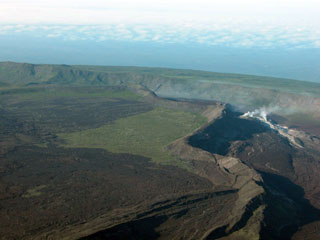 An aerial view of the SW caldera floor of Sierra Negra volcano shows El Azufre fumarolic field and the trap-door fault to the left. This sinuous 14-km-long, N-S-trending ridge occupies the west part of the caldera floor, which lies only about 100 m below its rim. El Azufre, the largest fumarolic area in the Galápagos Islands, lies within a graben between this ridge and the west caldera wall. The broad shield volcano of Sierra Negra at the southern end of Isabela Island contains a shallow 7 x 10.5 km caldera that is the largest in the Galápagos Islands.
 Photo by Patricio Ramon, 2005 (Instituto Geofisca, Escuela Politecnica Nacional).
 Symmetrical Cotopaxi is one of the most prominent volcanoes that line both sides of the Interandean valley along Ecuador's "Avenue of Volcanoes." Cotopaxi, one of Ecuador's most active volcanoes, has produced more than 50 eruptions since the 16th century. Glaciers cover the upper part of the cone from 4700 m altitude on the west flank, seen here, to the 5911-m-high summit. Devastating lahars in historical time swept this valley before turning south and then east into the Amazon basin. Lahars to the NW reached the Pacific Ocean.
 Photo by Lee Siebert, 1978 (Smithsonian Institution).
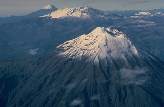 This aerial view looking SSE down Ecuador's Cordillera Real mountain range shows three 5000-m-high stratovolcanoes that have undergone varying degrees of erosion. Tungurahua volcano in the foreground rises more than 3000 m above its northern base and has produced some of Ecuador's most powerful explosive eruptions during historical time. Altar (center) is an extensively eroded volcano of Pleistocene age. Symmetrical, undissected Sangay volcano in the background is Ecuador's most active and has been in continuous eruption since 1934.
Copyrighted photo by Katia and Maurice Krafft, 1983.
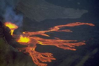 Lava fountains from Fernandina volcano in the Galápagos Islands feed multiple lobes of lava in 1978 that travel across a down-dropped block of the NW caldera bench, about 380 m below the caldera rim. The 1978 eruption began on 8 August when a 6-km-high eruption plume rose to be visible from distant locations in the archipelago. During the course of the eruption lava flows traveled 2 km into the caldera lake, more than 400 m below. Activity ended on 26 August.
Photo by Marc Orbach, 1978 (courtesy of Tom Simkin, Smithsonian Institution).
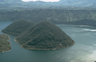 An explosive eruption about 2900 years ago produced widespread tephra and pyroclastic surges. Subsequently a group of four dacitic lava domes was constructed within Cuicocha caldera. This marks the latest known activity from the caldera. The eastern two domes are seen here from the SE rim of the caldera. The lava domes form two forested islands in the center of the 3-km-wide caldera.
Photo by Tom Pierson, 1992 (U.S. Geological Survey).
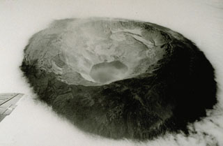 The 1968 eruption of Fernandina was one of the few historical instances in which caldera collapse has been documented. This oblique aerial photograph taken three weeks after the start of the caldera collapse shows Fernandina volcano from the ESE. The NW and SE benches and the central tuff cone (whose crater is partially filled by the small embayment at the top of the lake) can still be seen in this photograph, despite roughly 350 m subsidence of the SE caldera floor. Note the dust from rock avalanches on the oversteepened walls.
 Photo by U.S. Air Force, 1968 (published in Simkin and Howard, 1970).
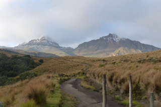 These two edifices form the Illiniza volcanic complex. Seen here from about 4 km NE, Illiniza Norte is to the right and Illiniza is to the left.
Photo by Ailsa Naismith, 2015.
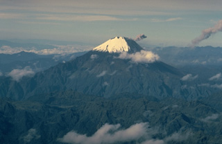 Sangay, Ecuador's most active volcano, towers above the tropical jungles east of the Andean crest. Ash darkens the SW flank in this September 1983 view. A small ash plume from the summit crater is deflected to the SW. A plume from the previous explosion forms the dark inclined cloud at the extreme right. More-or-less continual minor explosive eruptions have occurred from Sangay since 1934.
Copyrighted photo by Katia and Maurice Krafft, 1983.
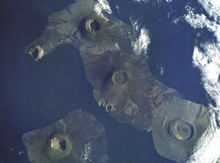 This dramatic Space Shuttle photo from a 1988 mission shows five major calderas of the Galápagos Islands. Caldera diameters capping these basasltic shield volcanoes range up to 8 km. At the lower left is Fernandina volcano. At the lower right is mostly vegetated Alcedo volcano on Isabela Island. Above and to the left is Darwin volcano, with the two prominent breached tuff cones, Tagus and Beagle, on its SW flank. Volcán Wolf is at the top of the photo, and Volcán Ecuador with its breached caldera forms the NW tip of Isabela Island.
NASA Space Shuttle image, 1988 (http://eol.jsc.nasa.gov/).
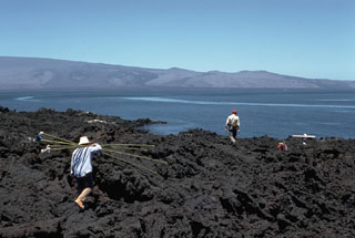 The smooth flank of Darwin shield volcano, seen here from the east coast of Fernandina Island, is modified by a cluster of tuff cones near the SW base of the volcano. The Tagus and Beagle tuff cones (right center horizon) were formed by phreatomagmatic eruptions along the SW coast of Darwin. Fresh black lava flows erupted from fissures on the flanks of Darwin volcano descend to the sea on both sides of the tuff-cone complex.
 Photo by Lee Siebert, 1978 (Smithsonian Institution).
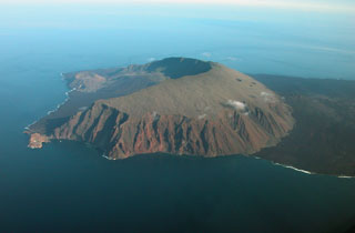 An aerial view of Volcán Ecuador from the south shows the large horseshoe-shaped caldera breached to the west that was formed when the volcano collapsed, producing a large submarine debris avalanche. The volcano straddles the equator at the NW end of Isabela Island. Two large pyroclastic cones were constructed along the coast, and smaller cones are found on the caldera floor. Extensive dark-colored lava flows (right) originate from a NE-trending line of fissures that extends from the outer eastern flanks of the main edifice.
 Photo by Patricio Ramon, 2005 (Instituto Geofisca, Escuela Politecnica Nacional).
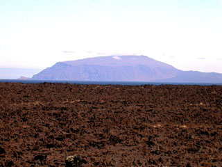 Volcán Ecuador, which straddles the equator at the NW end of Isabela Island, rises beyond a lava flow near Beagle tuff cone on the flanks of Darwin volcano. Ecuador is the smallest of the six large shield volcanoes on Isabela and is broadly breached to the coast on the side opposite this view. No historical eruptions are known; however, the youthful morphology of its most recent lava flows resembles those of very recent flows on other Isabela Island volcanoes. A line of NE-trending fissure-fed vents (right horizon) extends to the SE.
Photo by Ed Vicenzi, 2002 (Smithsonian Institution).
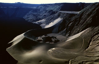 A large tuff cone occupies the ENE side of the summit caldera of Cerro Azul volcano at the SW tip of Isabela Island. A small caldera bench is seen above the cone at the upper right, and a larger bench on the northern side of the caldera is outlined by the light-colored line below the horizon at the upper left. The 4 x 5 km wide caldera is one of the smallest of the Galápagos shield volcanoes, but its 650 m depth makes it one of the deepest. Youthful dark-colored lava flows at the left cover much of the caldera floor.
Photo by Tom Simkin (Smithsonian Institution).
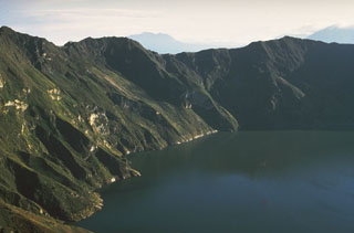 Quilotoa is a truncated, forested dacitic cone containing a steep-walled, 3-km-wide caldera filled by a 250-m-deep lake. Lava domes form the caldera's perimeter and occupy its floor. Its most recent large eruption about 800 years ago produced voluminous pyroclastic flows, lahars that reached the Pacific Ocean, and one of the largest airfall-tephra deposits of the northern Andes. Reports of historical eruptions from the caldera lake are somewhat ambiguous. Fumaroles are present on the lake floor and hot springs occur on the eastern flank.
 Photo by Minard Hall, 1973 (Escuela Politécnica Nacional, Quito).
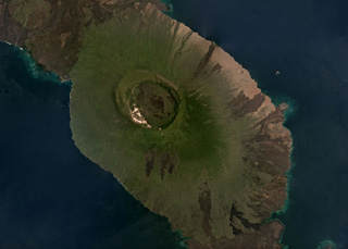 The summit caldera of the Alcedo shield volcano, 7-8.5 km in diameter, is near the center of this March 2019 Planet Labs satellite image monthly mosaic (N is at the top). The caldera contains rhyolite lavas, and both rhyolite tephra and pumice have erupted from three identified vents. Radial basalt lava flows form the flanks like the other five volcanoes that make up Isabela Island. The southern flank of Volcán Darwin is to the north and lava flows from Sierra Negra are to the south.
Satellite image courtesy of Planet Labs Inc., 2019 (https://www.planet.com/).
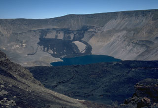 The dark lava flows at the far NW end of Fernandina caldera were emplaced in August 1978. An eruption beginning on August 8 produced an eruption cloud 4.5-6 km high. This was followed by the emplacement of a large lava flow from a 1-km-long fissure system on the NW caldera bench that flowed into the caldera lake. Lava fountaining was observed during visits to the caldera rim, on August 10-13 and 16-19. The eruption had ended by the 26th. Fresh lava flows in the foreground mantle the surface of the prominent SE caldera bench.
Photo by Lee Siebert, 1978 (Smithsonian Institution).
 Snow-capped Tungurahua, seen from near the town of Baños on its northern flank, rises 3200 m above steep-walled canyons. Historical eruptions, separated by long reposes, have produced powerful explosions, sometimes accompanied by pyroclastic flows and lava flows. All historical eruptions have originated from the summit crater, and have typically lasted for several years. The largest historical eruptions took place in 1886, 1916, and 1918.
Photo by Minard Hall, 1976 (Escuela Politécnica Nacional, Quito).
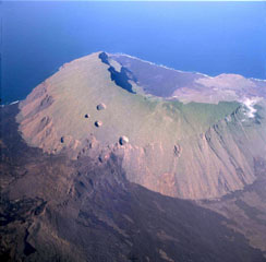 An aerial view from the NE shows Volcán Ecuador with its large caldera breached to the SW. Erosion has extensively modified the lower outer flanks of the volcano. East flank fissures at the lower left feed fresh lava flows, and large pit craters dot the upper eastern flank of the volcano. A large pyroclastic cone constructed on the floor of the caldera can be seen near the coast at the upper right, and fresh lava flows blanket the caldera floor.
 Photo by Patricio Ramon, 2004 (Instituto Geofisca, Escuela Politecnica Nacional).
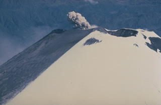 A small ash plume rises from the SW summit crater of Ecuador's Sangay volcano in September 1983 and ashfall darkens snow on the upper SW flank. Almost continuous minor explosive activity has occurred since 1934, occasionally accompanied by the emission of short lava flows.
Copyrighted photo by Katia and Maurice Krafft, 1983.
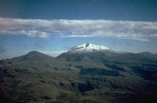 Cerro Negro de Mayasquer (Ieft) and snow-capped Volcán Chiles (right), seen here from the south, are twin volcanoes that straddle the Colombia-Ecuador border. Chiles volcano is of Pleistocene age, but has hot springs and an active hydrothermal system on its eastern flank. Cerro Negro de Mayasquer is a stratovolcano with a caldera open to the west. Andesitic and dacitic lava flows are of possible Holocene age. Solfataras are found on the shore of a small crater lake.
 Photo by Minard Hall, 1985 (Escuela Politécnica Nacional, Quito)
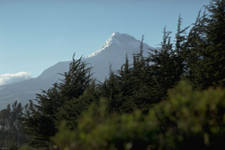 Illiniza Sur, seen here from the Interandean valley to its east, is the highest of the twin peaks of Illiniza volcano. A lava dome on its southern flank, Rasuyacu, erupted during the Holocene. Illiniza itself may have had relatively youthful eruptions, although none have been dated.
Photo by Lee Siebert, 1978 (Smithsonian Institution).
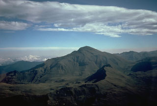 Cerro Negro de Mayasquer is the youngest of a pair of twin volcanoes along the Ecuador-Colombia border. It is seen here from the Ecuadorian side on the south. The long ridge to the left of its summit is the rim of a horseshoe-shaped caldera that is breached to the NW.
Photo by Minard Hall, 1985 (Escuela Politécnica Nacional, Quito)
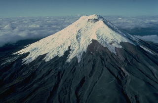 The symmetrical, glacier-clad Cotopaxi stratovolcano is Ecuador's best known volcano and one of its most active. The steep-sided cone, seen here in an aerial view from the north, is capped by nested summit craters 650 x 800 m in diameter. Lahars accompanying explosive eruptions of Cotopaxi have frequently devastated adjacent valleys. In 1877, during one of the largest historical eruptions, pyroclastic flows descended all sides of the volcano and lahars traveled more than 200 km into the Pacific Ocean and the western Amazon basin.
 Copyrighted photo by Katia and Maurice Krafft, 1983.
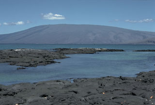 Volcán Darwin, named after the Charles Darwin, seen above a narrow channel opposite Point Espinosa on the NE tip of Fernandina Island. Darwin volcano has 5-km-wide summit caldera that is largely filled by lava flows. The most recent summit activity produced several small lava flows from vents on the eastern caldera floor, and NE and SE caldera rims. Two breached tuff cones on the SW-flank coast, Tagus and Beagle, were a prominent part of Darwin's geological studies in the Galápagos Islands.
Photo by Lee Siebert, 1978 (Smithsonian Institution).
 An aerial view from the east shows the Pichincha volcanic complex, one of Ecuador's most active volcanoes, rising immediately above the capital city of Quito. Guagua Pichincha (left) and the sharp-topped Pleistocene Rucu Pichincha stratovolcano (right) form a broad volcanic massif overlooking Ecuador's largest city. The largest historical eruption from Guagua Pichincha took place in 1660 CE, when ash fell over a 1000 km radius, accumulating to 30 cm depth in Quito.
 Photo by Patricio Ramon, 2004 (Instituto Geofisca, Escuela Politecnica Nacional).
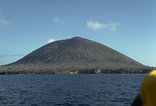 An unnamed 394-m-high cinder cone is a prominent landmark near James Bay at the western end of Santiago Island. The eruptions that constructed the cone were initially submarine, producing palagonitic tuffs. As the cone grew above sea level, subaerial explosions produced basaltic scoria that forms the upper part of the cone. A similar, but smaller cone lies immediately to the SE, out of view to the right.
Photo by Lee Siebert, 1978 (Smithsonian Institution).
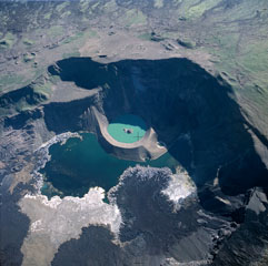 A near vertical aerial photo shows the caldera of Cerro Azul with north to the lower left. The lava flow extending into the caldera lake from the bottom of the image was erupted in September 1998. Lava flows were erupted in September and October 1998 from vents on the south caldera bench and west caldera floor. Another vent from a radial fissure at 630-680 m elevation on the SE flank produced a lava flow that reached to within about 2 km of the ocean.
 Photo by Patricio Ramon, 2003 (Instituto Geofisca, Escuela Politecnica Nacional).
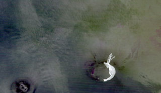 The light-colored area at the lower right in this false color ASTER infrared image shows the extent of lava flows from the October 2005 eruption of Sierra Negra volcano. The image, taken at night on November 2, about 3 days after the eruption ended, shows thin lava flows that descended the north flank and the lunate zone of ponded lavas on the eastern-to-southern caldera floor deflected by caldera wall. Neighboring Cerro Azul volcano on SW Isabela Island is visible at the lower left.
 NASA ASTER image, 2005 (created by Jesse Allen, NASA Earth Observatory).
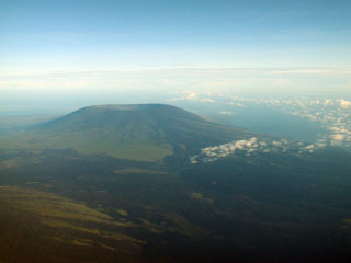 The caldera of Cerro Azul volcano is seen from the east, with the slopes of Sierra Negra volcano in the foreground. The steep-walled 4 x 5 km nested summit caldera complex is 650 m deep. Dark-colored, fresh-looking lava flows erupted from NE flank vents can be seen at the right, and a SE flank fissure erupted in 1998, producing a lava flow that reached to within 2 km of the coast.
 Photo by Patricio Ramon, 2003 (Instituto Geofisca, Escuela Politecnica Nacional).
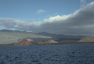 The elongated shield volcano of Santiago Island is dotted with Holocene pyroclastic cones. Fresh lava flows that blanket the flanks of the volcano originated from these cones. The 920-m-high summit ridge, lined with NW-trending cinder and spatter cones, is seen here from James Bay on the west side of the island. The James Bay lava flows (center) reached the coast along a broad front. They were dated by fragments of marmalade pots left by buccaneers in 1684 that were subsequently embedded in the lava flows observed by Charles Darwin in 1835.
 Photo by Lee Siebert, 1978 (Smithsonian Institution).
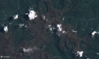 The Aliso volcanic complex is composed of lava domes, dome collapse deposits, ignimbrites, lava flows, and lahar deposits. The area is shown in this 4 September 2019 Sentinel-2 satellite image, which is approximately 12 km across. It is located in the jungle east of the town of Baeza in Ecuador.
Satellite image courtesy of Planet Labs Inc., 2019 (https://www.planet.com/).
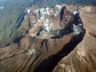 A large breached caldera formed by edifice collapse during the Pleistocene truncates the summit of 4784-m-high Guagua Pichincha volcano, which overlooks Ecuador's capital city, Quito. A lava dome was constructed within the active crater at the head of the collapse scarp.
Photo by Patricio Ramon, 2003 (Escuela Politécnica Nacional, Quito).
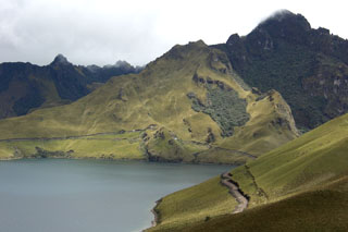 Laguna Grande de Mojanda occupies the caldera of Mojanda volcano, one of the largest volcanoes of Ecuador's northern Interandean Depression. This view looks toward the rugged eastern rim of the caldera from the slopes of the post-caldera stratovolcano Fuya Fuya with Cerro Negro at the upper right. Laguna Grande de Mojanda is one of two lakes occupying a summit caldera cutting an older Mojanda edifice. Fuya Fuya volcano was constructed immediately to the west of Mojanda and produced two major rhyolitic plinian explosive eruptions.
Photo by Lee Siebert, 2006 (Smithsonian Institution).
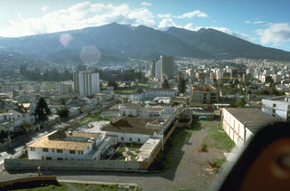 Guagua Pichincha volcano towers over Ecuador's capital city of Quito. The historically active vent of Guagua Pichincha is located within a large, steep-walled caldera that is breached to the west, in a direction opposite the city. This has served to funnel pyroclastic flows and mudflows away from Quito. Most historical eruptions have been relatively minor, although an explosive eruption in 1660 dropped 30 cm of ash on the city.
Photo by Norm Banks, 1988 (U.S. Geological Survey).
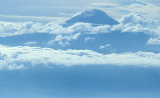 Clouds drape glacier-clad, 6310-m-high Chimborazo, Ecuador's highest volcano. Chimborazo anchors the southern end of the country's "Avenue of Volcanoes" 30 km NW of the city of Riobamba. The volcano is mostly of Pliocene-to-Pleistocene age, but recent work has shown that it remained active into the Holocene. The volcano is composed of three edifices along an east-west line, the youngest and westernmost of which forms the current summit of Chimborazo.
 Photo by Lee Siebert, 1978 (Smithsonian Insitution).
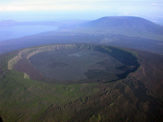 A spectacular aerial view from the SE shows the caldera of Darwin volcano in the foreground, with Volcán Wolf in the right background and the tip of Volcán Ecuador at the NW tip of Isabella Island on far left horizon. Volcán Darwin, named after the renowned naturalist, contains a symmetrical 5-km-wide, 200-m-deep summit caldera whose floor is nearly covered by youthful lava flows. A broad terrace occupies the SW part of the caldera (left side). Fresh-looking, dark-colored lava flows from flank fissures are visible between Darwin and Wolf volcanoes.
 Photo by Patricio Ramon, 2003 (Instituto Geofisca, Escuela Politecnica Nacional).
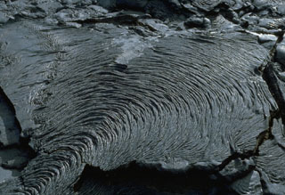 The ropy texture of pahoehoe lava flows is produced when the thin solidifying surface of the flow is pushed by the advancing, still-molten interior. This pleated pahoehoe lobe, on a lava flow at Santiago shield volcano in the Galápagos Islands, advanced slowly from the bottom left to the top right. Pahoehoe lavas are the least viscous of common lava types, and thus form diverse surface structures.
Photo by Lee Siebert, 1978 (Smithsonian Institution).
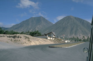 Cerro Sincholagua (left) and Loma la Marca (right) are the southernmost of a group of lava domes at Pululahua volcano. Seen here from the south, they are part of a chain of lava domes that were constructed on a roughly N-S line east of the Pululahua caldera.
Photo by Lee Siebert, 1978 (Smithsonian Institution).
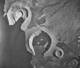 The tuff cones of Tagus (upper left) and Beagle (lower right) were formed by phreatomagmatic eruptions at Darwin volcano in the Galápagos Islands. The rim of Tagus is breached by Tagus Cove that was visited by Charles Darwin's vessel, the Beagle. Tagus tuff cone has at least four nested craters, the youngest of which contains a small salt lake. Young black lava flows from fissures on the flanks largely surround the tuff cones.
Aerial photo by U.S. Air Force.
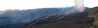 This composite view looks west from the NE rim of Sierra Negra's caldera (right) on October 23, 2005. The caldera floor is to the left. Four active vents are superimposed in this photo, aligned along the E-W fracture that lies at the base of the inner caldera wall. Numerous lava flows descended southwards to the left where they joined to form one single flow of a'a lava ~ 1 km wide and 7 km long that had already reached the southern inner wall of the caldera on the 23rd.
Photo by Minard Hall, 2005 (Escuela Politecnica Nacional, Quito).
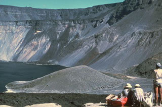 The tuff cone at the lower center, seen here from the NW in 1978, dropped 280 m during collapse of the Fernandina caldera floor in 1968. Collapse occurred in a piecemeal fashion over a period of about two weeks and the 110-m-high tuff cone, which previously formed an island in the caldera lake, rode the collapse downward without fracturing. The tuff cone was later buried by a 1991 lava flow following a 1988 debris avalanche. The prominent SE caldera bench is seen at the far side of the roughly 1-km-deep caldera.
Photo by Chuck Wood, 1978 (Smithsonian Institution).
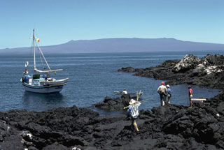 Alcedo is one of the lowest and smallest of six shield volcanoes on Isabela Island. Seen here from the coast of Fernandina Island to its west, Alcedo has a 7-8 km wide summit caldera. Most of the flanks and summit caldera are vegetated, but young lava flows are prominent on the N flank near the saddle with Darwin volcano. Alcedo is the only Galápagos volcano known to have erupted rhyolite as well as basalt.
 Photo by Lee Siebert, 1978 (Smithsonian Institution).
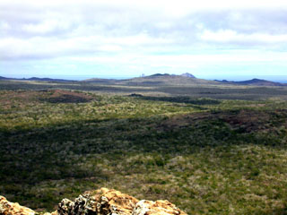 The NW coast of San Cristóbal Island contains numerous young pyroclastic cones, spatter vents, and lava flows. The island consists of a densely vegetated SW part and a lower, younger NE part with many extremely youthful lava flows. The tip of Kicker Rock, two steep-cliffed islands separated by a narrow cleft, is barely visible on the center horizon. Kicker Rock is an eroded remnant of a tuff cone that forms one of the scenic highlights of the Galápagos, 5 km off the west coast of San Cristóbal.
Photo by Ed Vicenzi, 2002 (Smithsonian Institution).
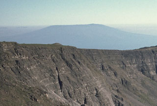 Cerro Azul volcano at the SW tip of J-shaped Isabela Island rises in the distance above the rim of Fernandina caldera. The flat-topped shield volcano is truncated by a deep, steep-walled 4 x 5 km summit caldera. A prominent cinder cone is located at the ENE side of the caldera and youthful lava flows cover its floor. Numerous spatter cones dot the western flanks. Fresh-looking lava flows, many erupted from circumferential fissures, descend the NE and NW flanks. Historical eruptions date back only to 1932.
 Photo by Lee Siebert, 1978 (Smithsonian Institution).
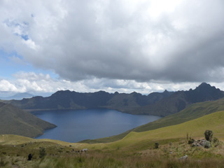 The Mojanda summit caldera formed during a Plinian eruption ~200,000 years ago and now has three lakes. In the indigenous Quechua language they are Karikucha (Male Lake), Yanakucha (Black Lake), and Warmikucha (Female Lake). This October 2015 photograph is looking E towards Karikucha lake from the upper slopes of Mojanda.
Photo by Ailsa Naismith, 2015.
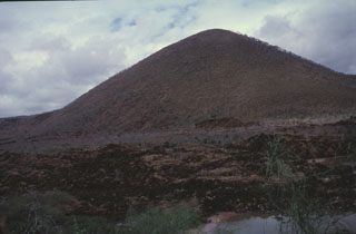 A sparsely vegetated lava flow appears in the foreground below Cerro Pajas, one of the more than 50 cinder cones dotting Floreana Island. Several young lava flows on Floreana, also known as Charles Island or Santa María Island, were considered due to their morphology to be Holocene, but Pleistocene surface exposure ages were obtained. Cerro Pajas, the most conspicuous of the cinder cones on the island, fed a massive pahoehoe lava flow that reached the SW coast over a broad 6.5 km area.
Photo by Carlos Pullinger, 1996 (Servicio Nacional de Estudios Territoriales, El Salvador).
 Volcán el Soche is a small volcano near the Ecuador-Colombia border and is seen in the center of this December 2017 Planet Labs satellite image monthly mosaic (N is at the top; this image is approximately 9.5 km across). Soche is the northernmost of a chain of Ecuadorian volcanoes east of the principal volcanic axis and was the source of a major explosive eruption during the early Holocene.
Satellite image courtesy of Planet Labs Inc., 2018 (https://www.planet.com/).
This is a compilation of Ecuador volcano information sources, such as official monitoring or other government agencies.
| Volcano Observatories |
|---|
| Instituto Geofísico-Escuela Politécnica Nacional (IG-EPN) |
| - IG-EPN Reports |
| - IG-EPN Facebook |
| - IG-EPN X |
| Civil Protection Agencies |
|---|
| Secretaría Nacional de Gestión de Riesgos (SNGR) |
| - SNGR Notices |
| - SNGR Notices Facebook |
| - SNGR Notices X |
| Additional Information Sources |
|---|
| Parque Nacional Galápagos |
| - Parque Nacional Galápagos Facebook |
| - Parque Nacional Galápagos X |
| Volcanic Ash Advisory Center |
|---|
| Washington Volcanic Ash Advisory Center (VAAC) |
| - Washington VAAC Notices and Archive |