
| Country | Bolivia |
| Volcanic Region | Central Andean Volcanic Arc |
| Landform | Volc Type | Composite | Stratovolcano |
| Last Known Eruption | Pleistocene |
| Coordinates | 22.27°S, 67.18°W |
| Elevation | 6,008 m (19,711 ft) |
| Volcano Number | 355838 |
 Google Earth Placemark with Features Google Earth Placemark with Features
| |
 Cite Volcano Profile Cite Volcano Profile
| |
The Global Volcanism Program has no Weekly Volcanic Activity Reports available for Uturuncu.
Cite this Report
Deformation detected by satellite surveys; low-level seismicity and active fumaroles
A large-scale concentric pattern of deformation was detected between May 1996 and December 2000 centered on Uturuncu volcano, Bolivia (figure 1), based on satellite geodetic surveys (Pritchard and Simons, 2002). The observed deformation is primarily surface uplift with a maximum rate at the uplift center of 1-2 cm/year in the radar line-of-sight direction (figure 2). A reconnaissance investigation by a team composed of scientists from Bolivia, Chile, the USA, and the UK, took place during 1-6 April 2003 to identify any other signs of volcanic unrest and assess past volcanic behavior.
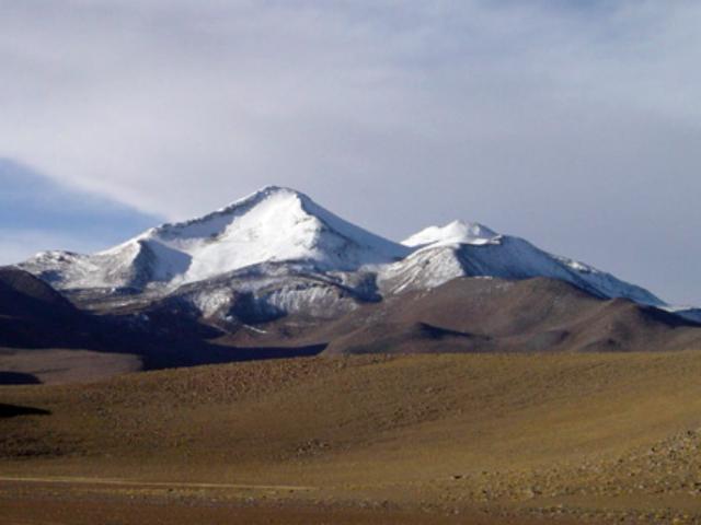 |
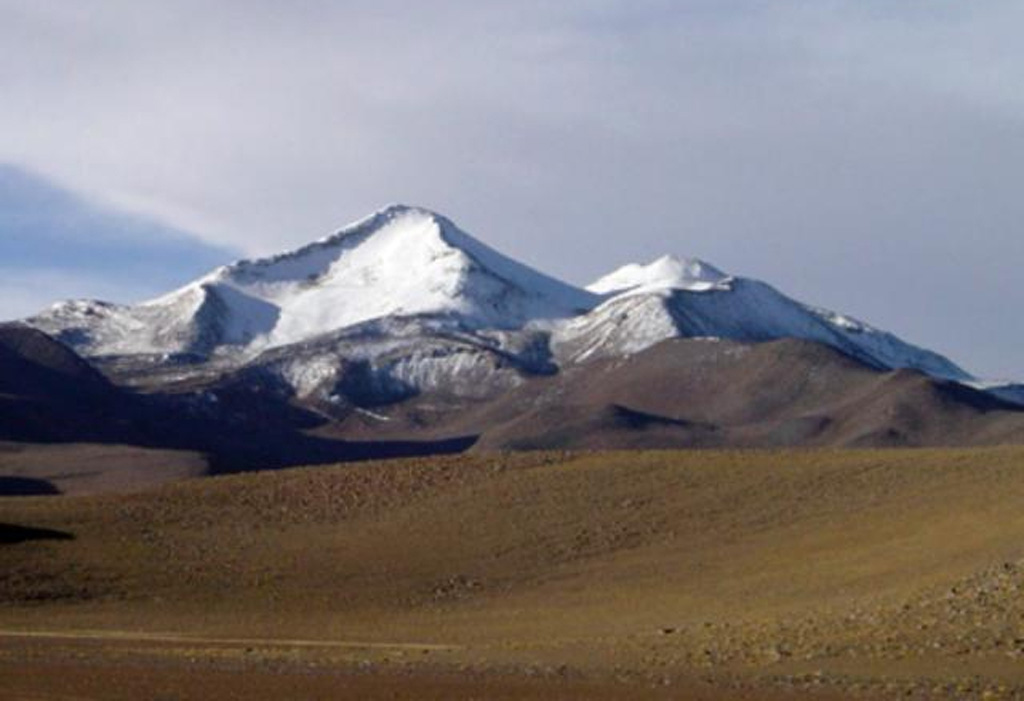
Figure 1. Photograph of Uturuncu viewed from the south, April 2003. Courtesy of Steve Sparks. |
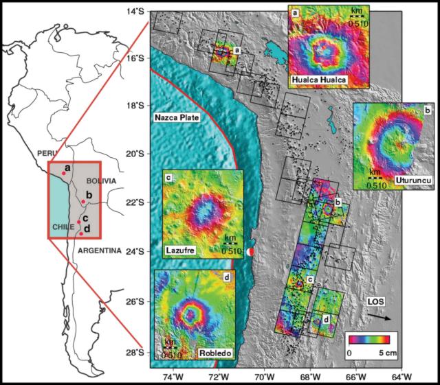 |
Figure 2. Shaded relief topographic map of the central Andes with insets showing areas of deformation detected by Pritchard and Simons (2002). Interferograms (draped over shaded relief) indicate active deformation; each color cycle corresponds to 5 cm of deformation in the radar line-of-sight (LOS). The LOS direction from ground to spacecraft (black arrow) is inclined 23° from the vertical. Black squares indicate radar frames, and black triangles show potential volcanic edifices. Courtesy of Matthew Pritchard. |
A single-component vertical one-second seismometer was placed at five locations for periods of up to 14 hours. Data were recorded at a rate of 100 samples per second on a laptop computer. Persistent low-level seismicity was observed mainly from one source location on the NW flank, close to the center of deformation observed by satellite surveys. Two other sources within the volcanic edifice could not be located with the available data. The rate of volcanic earthquakes was up to 15 per hour, and the magnitudes were in the 0.5-1.5 range based on coda length. The sources were considered to be within 3-4 km of the surface (much shallower than the deformation source); more accurate information will be available when the data are analyzed further.
The summit region of Uturuncu has two active fumarole fields with substantial sulfur production and areas of clay-silica hydrothermal alteration. Maximum temperatures in four fumaroles were measured at 79-80°C. A hot spring on the NW flanks had a temperature of 20°C.
Uturuncu is a stratovolcano composed of hypersthene andesites, hypersthene-biotite dacites, and biotite-hornblende dacites. Almost all the exposed products are extensive coulée-type lavas and domes; no pyroclastic deposits were observed. Flow features are well-preserved on the youngest lavas. A wide variety of xenoliths were found in most lavas, including mafic magmatic inclusions, cumulates, microcrystalline igneous inclusions, and hornfels of possible basement rocks including sandstones and calcareous rock types.
Lavas around the summit area appear to be the most recent products, but have been affected by glaciation; there is however no present-day ice. There is thus no evidence yet for Holocene activity. The recent unrest manifested by substantial ground deformation and reconnaissance seismicity indicate, however, that a magmatic system is still present and therefore further monitoring is warranted.
Reference. Pritchard, M., and Simons, M., 2002, A satellite geodetic survey of large-scale deformation of volcanic centres in the Central Andes: Nature, v. 418, p. 167-170.
Information Contacts: Mayel Sunagua and Ruben Muranca, Geological Survey of Bolivia, SERGEOMIN, Casilla 2729, La Paz, Bolivia; Jorge Clavero, Geological Survey of Chile, Servicio Nacional de Geología y Minería (SERGEOMIN), Avenida Santa María 0104, Casilla 10465, Santiago, Chile; Steve McNutt, Alaska Volcano Observatory and Geophysical Institute, University of Alaska Fairbanks, 903 Koyukuk Drive, PO Box 757320, Fairbanks, AK 99775-7320, USA (URL: http://www.avo.alaska.edu/); Matthew Pritchard, Division of Geological and Planetary Sciences, California Institute of Technology, Pasadena, CA 91125, USA (URL: http://www.gps.caltech.edu/); C. Annen, M. Humphreys, A. le Friant, and R.S.J. Sparks, Department of Earth Sciences, University of Bristol, Bristol BS8 1RJ, UK.
The Global Volcanism Program has no Weekly Reports available for Uturuncu.
Reports are organized chronologically and indexed below by Month/Year (Publication Volume:Number), and include a one-line summary. Click on the index link or scroll down to read the reports.
05/2003 (BGVN 28:05) Deformation detected by satellite surveys; low-level seismicity and active fumaroles
Information is preliminary and subject to change. All times are local (unless otherwise noted)
Cite this Report
Deformation detected by satellite surveys; low-level seismicity and active fumaroles
A large-scale concentric pattern of deformation was detected between May 1996 and December 2000 centered on Uturuncu volcano, Bolivia (figure 1), based on satellite geodetic surveys (Pritchard and Simons, 2002). The observed deformation is primarily surface uplift with a maximum rate at the uplift center of 1-2 cm/year in the radar line-of-sight direction (figure 2). A reconnaissance investigation by a team composed of scientists from Bolivia, Chile, the USA, and the UK, took place during 1-6 April 2003 to identify any other signs of volcanic unrest and assess past volcanic behavior.
|
Figure 1. Photograph of Uturuncu viewed from the south, April 2003. Courtesy of Steve Sparks. |
|
Figure 2. Shaded relief topographic map of the central Andes with insets showing areas of deformation detected by Pritchard and Simons (2002). Interferograms (draped over shaded relief) indicate active deformation; each color cycle corresponds to 5 cm of deformation in the radar line-of-sight (LOS). The LOS direction from ground to spacecraft (black arrow) is inclined 23° from the vertical. Black squares indicate radar frames, and black triangles show potential volcanic edifices. Courtesy of Matthew Pritchard. |
A single-component vertical one-second seismometer was placed at five locations for periods of up to 14 hours. Data were recorded at a rate of 100 samples per second on a laptop computer. Persistent low-level seismicity was observed mainly from one source location on the NW flank, close to the center of deformation observed by satellite surveys. Two other sources within the volcanic edifice could not be located with the available data. The rate of volcanic earthquakes was up to 15 per hour, and the magnitudes were in the 0.5-1.5 range based on coda length. The sources were considered to be within 3-4 km of the surface (much shallower than the deformation source); more accurate information will be available when the data are analyzed further.
The summit region of Uturuncu has two active fumarole fields with substantial sulfur production and areas of clay-silica hydrothermal alteration. Maximum temperatures in four fumaroles were measured at 79-80°C. A hot spring on the NW flanks had a temperature of 20°C.
Uturuncu is a stratovolcano composed of hypersthene andesites, hypersthene-biotite dacites, and biotite-hornblende dacites. Almost all the exposed products are extensive coulée-type lavas and domes; no pyroclastic deposits were observed. Flow features are well-preserved on the youngest lavas. A wide variety of xenoliths were found in most lavas, including mafic magmatic inclusions, cumulates, microcrystalline igneous inclusions, and hornfels of possible basement rocks including sandstones and calcareous rock types.
Lavas around the summit area appear to be the most recent products, but have been affected by glaciation; there is however no present-day ice. There is thus no evidence yet for Holocene activity. The recent unrest manifested by substantial ground deformation and reconnaissance seismicity indicate, however, that a magmatic system is still present and therefore further monitoring is warranted.
Reference. Pritchard, M., and Simons, M., 2002, A satellite geodetic survey of large-scale deformation of volcanic centres in the Central Andes: Nature, v. 418, p. 167-170.
Information Contacts: Mayel Sunagua and Ruben Muranca, Geological Survey of Bolivia, SERGEOMIN, Casilla 2729, La Paz, Bolivia; Jorge Clavero, Geological Survey of Chile, Servicio Nacional de Geología y Minería (SERGEOMIN), Avenida Santa María 0104, Casilla 10465, Santiago, Chile; Steve McNutt, Alaska Volcano Observatory and Geophysical Institute, University of Alaska Fairbanks, 903 Koyukuk Drive, PO Box 757320, Fairbanks, AK 99775-7320, USA (URL: http://www.avo.alaska.edu/); Matthew Pritchard, Division of Geological and Planetary Sciences, California Institute of Technology, Pasadena, CA 91125, USA (URL: http://www.gps.caltech.edu/); C. Annen, M. Humphreys, A. le Friant, and R.S.J. Sparks, Department of Earth Sciences, University of Bristol, Bristol BS8 1RJ, UK.
|
|
||||||||||||||||||
The Global Volcanism Program is not aware of any Holocene eruptions from Uturuncu. If this volcano has had large eruptions (VEI >= 4) prior to 12,000 years ago, information might be found on the Uturuncu page in the LaMEVE (Large Magnitude Explosive Volcanic Eruptions) database, a part of the Volcano Global Risk Identification and Analysis Project (VOGRIPA).
The Global Volcanism Program has no synonyms or subfeatures listed for Uturuncu.
There are no samples for Uturuncu in the Smithsonian's NMNH Department of Mineral Sciences Rock and Ore collection.
| Copernicus Browser | The Copernicus Browser replaced the Sentinel Hub Playground browser in 2023, to provide access to Earth observation archives from the Copernicus Data Space Ecosystem, the main distribution platform for data from the EU Copernicus missions. |
|
WOVOdat
Single Volcano View Temporal Evolution of Unrest Side by Side Volcanoes |
WOVOdat is a database of volcanic unrest; instrumentally and visually recorded changes in seismicity, ground deformation, gas emission, and other parameters from their normal baselines. It is sponsored by the World Organization of Volcano Observatories (WOVO) and presently hosted at the Earth Observatory of Singapore.
GVMID Data on Volcano Monitoring Infrastructure The Global Volcano Monitoring Infrastructure Database GVMID, is aimed at documenting and improving capabilities of volcano monitoring from the ground and space. GVMID should provide a snapshot and baseline view of the techniques and instrumentation that are in place at various volcanoes, which can be use by volcano observatories as reference to setup new monitoring system or improving networks at a specific volcano. These data will allow identification of what monitoring gaps exist, which can be then targeted by remote sensing infrastructure and future instrument deployments. |
| EarthScope Consortium SAGE seismic stations/networks | EarthScope Consortium operates the NSF Geodetic Facility for the Advancement of Geoscience (GAGE) and NSF Seismological Facility for the Advancement of Geoscience (SAGE). The linked map shows the location of seismic stations from all available networks (permanent or temporary) within a radius of 0.18° (about 20 km at mid-latitudes) from the given location of Uturuncu. Users can customize a variety of filters and options in the left panel. Note that if there are no stations are known the map will default to show the entire world with a "No data matched request" error notice. |
| Large Eruptions of Uturuncu | Information about large Quaternary eruptions (VEI >= 4) is cataloged in the Large Magnitude Explosive Volcanic Eruptions (LaMEVE) database of the Volcano Global Risk Identification and Analysis Project (VOGRIPA). |
| EarthChem | EarthChem develops and maintains databases, software, and services that support the preservation, discovery, access and analysis of geochemical data, and facilitate their integration with the broad array of other available earth science parameters. EarthChem is operated by a joint team of disciplinary scientists, data scientists, data managers and information technology developers who are part of the NSF-funded data facility Integrated Earth Data Applications (IEDA). IEDA is a collaborative effort of EarthChem and the Marine Geoscience Data System (MGDS). |


 Snow-capped Uturuncu, the highest peak of SW Bolivia, rises to 6008 m. Andesitic and dacitic lava flows dominate on Uturuncu, seen here from the south. Although andesitic and dacitic lava flows display well-preserved flow features, youthful-looking summit lava flows show evidence of glaciation. Two active sulfur-producing fumarole fields are located near the summit. Large-scale ground deformation observed beginning in May 1992, along with recently detected seismicity, indicates that a magmatic system is still present.