
A seismic swarm at São Jorge began at 1605 on 19 March along a WNW-ESE fissure system stretching from Ponta dos Rosais to Norte Pequeno - Silveira. The seismic data as well as deformation data indicated a magmatic intrusion, though by early April no significant deformation was detected. The frequency of earthquakes had decreased in late May-early June, leading CIVISA to lower the Alert Level to V3 (on a scale of V0-V6) on 8 June. Seismicity continued to be elevated; by 18 July a total of 43,410 low-magnitude tectonic events had been recorded.
Source: Centro de Informação e Vigilância Sismovulcânica dos Açores (CIVISA)
A seismic swarm beneath the W half of São Jorge began at 1605 on 19 March, with earthquakes along the Manadas volcanic fissure system between Velas (S side of the island) and Fajã do Ouvidor (N coast). On 31 March there were 714 seismic events detected, according to a preliminary analysis of seismic records. As the week progressed, the number of daily events fluctuated from 397 on 1 April to 592 on 5 April; magnitudes were relatively low. The Alert Level remained at V4 (on a scale of V0-V6).
Source: Centro de Informação e Vigilância Sismovulcânica dos Açores (CIVISA)
A seismic swarm beneath the W half of São Jorge began at 1605 on 19 March, with earthquakes along the Manadas volcanic fissure system between Velas (S side of the island) and Fajã do Ouvidor (N coast). CIVISA raised the Alert Level to V2 and then V3 (on a scale of V0-V6) during the morning of 20 March, and finally to V4 that afternoon. On 22 March Proteção Civil e Bombeiros dos Açores noted that, although no official evacuations had been issued, vulnerable people such as patients in the Velas health center were being moved to other locations on the island. Supplies were being distributed to São Jorge Island and residents were encouraged to prepare in case of a volcanic eruption. On 23 March a VONA was issued, announcing that the Aviation Color Code was raised to Yellow (on a four-color scale). The total estimated population of the island was around 8,400 people; according to a news report, about 1,250 residents left the island during 23-24 March. Most of the earthquakes were low magnitude, M 1.6-3.3, though about 209 of them were felt by residents; the largest event, a M 3.8, was detected near Velas at 2256 on 29 March. By 30 March a total of about 20,000 events had been recorded. Besides the increased seismicity, CIVISA noted that ground-based Global Navigation Satellite System (GNSS) data showed inflation, which was also suggested by satellite-based data processed by partners.
Sources: Portuguese American Journal; Centro de Informação e Vigilância Sismovulcânica dos Açores (CIVISA); Proteção Civil e Bombeiros dos Açores; U.S. News; Reuters; Açoriano Oriental; Açoriano Oriental
The Global Volcanism Program has no Bulletin Reports available for São Jorge.
|
|
||||||||||||||||||||||||||||
There is data available for 10 confirmed eruptive periods.
[ 1964 Feb 18 - 1964 Feb 18 ] Uncertain Eruption
| Episode 1 | Uncertain | Submarine off SW coast | ||||||||||||||||||
|---|---|---|---|---|---|---|---|---|---|---|---|---|---|---|---|---|---|---|---|
| 1964 Feb 18 - 1964 Feb 18 | Evidence from Unknown | ||||||||||||||||||
| Suspected submarine activity connected with seismic swarm. | |||||||||||||||||||
|
List of 2 Events for Episode 1 at Submarine off SW coast
|
|||||||||||||||||||
[ 1907 ] Discredited Eruption
Submarine eruption (no details) listed in Mitchell-Thome (1981). This event has not been included in later eruptions lists by Azores volcanologists (through 2021), and may have been mistaken for the 1907 submarine eruption near Monaco Bank, S of Sao Miguel Island.
1902 May 7 - 1902 May 8 Confirmed Eruption (Explosive / Effusive) VEI: 0
| Episode 1 | Eruption (Explosive / Effusive) | Submarine, ~27 km ESE of Ponta do Topo | ||||||||||||||||||
|---|---|---|---|---|---|---|---|---|---|---|---|---|---|---|---|---|---|---|---|
| 1902 May 7 - 1902 May 8 | Evidence from Observations: Reported | ||||||||||||||||||
|
List of 2 Events for Episode 1 at Submarine, ~27 km ESE of Ponta do Topo
|
|||||||||||||||||||
1808 May 1 - 1808 Jun 10 Confirmed Eruption (Explosive / Effusive) VEI: 1
| Episode 1 | Eruption (Explosive / Effusive) | Sao Jorge | |||||||||||||||||||||||||||||||||||||||||||
|---|---|---|---|---|---|---|---|---|---|---|---|---|---|---|---|---|---|---|---|---|---|---|---|---|---|---|---|---|---|---|---|---|---|---|---|---|---|---|---|---|---|---|---|---|
| 1808 May 1 - 1808 Jun 10 | Evidence from Observations: Reported | |||||||||||||||||||||||||||||||||||||||||||
|
List of 7 Events for Episode 1 at Sao Jorge
|
||||||||||||||||||||||||||||||||||||||||||||
1800 Jun 24 - 1800 Jun 25 Confirmed Eruption (Explosive / Effusive) VEI: 2
| Episode 1 | Eruption (Explosive / Effusive) | Submarine, ~35 km SE of Ponta do Topo | ||||||||||||||||||
|---|---|---|---|---|---|---|---|---|---|---|---|---|---|---|---|---|---|---|---|
| 1800 Jun 24 - 1800 Jun 25 | Evidence from Observations: Reported | ||||||||||||||||||
|
List of 2 Events for Episode 1 at Submarine, ~35 km SE of Ponta do Topo
|
|||||||||||||||||||
[ 1757 Jul 9 - 1757 Jul 10 ] Discredited Eruption
Reported eruption coincided with a M 7.4 earthquake; supposedly 18 ephemeral islets formed during this activity. This event is not generally included in eruption lists by Azores volcanologists (through 2021), so was probably simply effects of the earthquake.
1580 May 1 - 1580 Aug 30 (?) Confirmed Eruption (Explosive / Effusive) VEI: 3 (?)
| Episode 1 | Eruption (Explosive / Effusive) | Sao Jorge (SW side) | |||||||||||||||||||||||||||||||||||||||||||
|---|---|---|---|---|---|---|---|---|---|---|---|---|---|---|---|---|---|---|---|---|---|---|---|---|---|---|---|---|---|---|---|---|---|---|---|---|---|---|---|---|---|---|---|---|
| 1580 May 1 - 1580 Aug 30 (?) | Evidence from Observations: Reported | |||||||||||||||||||||||||||||||||||||||||||
|
List of 7 Events for Episode 1 at Sao Jorge (SW side)
|
||||||||||||||||||||||||||||||||||||||||||||
1483 Confirmed Eruption (Explosive / Effusive)
| Episode 1 | Eruption (Explosive / Effusive) | Sao Jorge | |||
|---|---|---|---|---|
| 1483 - Unknown | Evidence from Isotopic: 14C (calibrated) | |||
1426 Confirmed Eruption (Explosive / Effusive)
| Episode 1 | Eruption (Explosive / Effusive) | Sao Jorge | |||
|---|---|---|---|---|
| 1426 - Unknown | Evidence from Isotopic: 14C (calibrated) | |||
1293 Confirmed Eruption (Explosive / Effusive)
| Episode 1 | Eruption (Explosive / Effusive) | Sao Jorge | |||
|---|---|---|---|---|
| 1293 - Unknown | Evidence from Isotopic: 14C (calibrated) | |||
1282 Confirmed Eruption (Explosive / Effusive)
| Episode 1 | Eruption (Explosive / Effusive) | Sao Jorge | |||
|---|---|---|---|---|
| 1282 - Unknown | Evidence from Isotopic: 14C (calibrated) | |||
0412 Confirmed Eruption (Explosive / Effusive)
| Episode 1 | Eruption (Explosive / Effusive) | Sao Jorge | |||
|---|---|---|---|---|
| 0412 - Unknown | Evidence from Isotopic: 14C (calibrated) | |||
2137 BCE Confirmed Eruption (Explosive / Effusive)
| Episode 1 | Eruption (Explosive / Effusive) | Sao Jorge | |||
|---|---|---|---|---|
| 2137 BCE - Unknown | Evidence from Isotopic: 14C (calibrated) | |||
This compilation of synonyms and subsidiary features may not be comprehensive. Features are organized into four major categories: Cones, Craters, Domes, and Thermal Features. Synonyms of features appear indented below the primary name. In some cases additional feature type, elevation, or location details are provided.
Synonyms |
||||
| San Jorge | ||||
Cones |
||||
| Feature Name | Feature Type | Elevation | Latitude | Longitude |
| 1800 Eruption Vent | Vent | -400 m | 38° 27' 7.00" N | 27° 22' 7.00" W |
| 1902 Eruption Vent | Vent | -700 m | 38° 31' 2.00" N | 27° 26' 8.00" W |
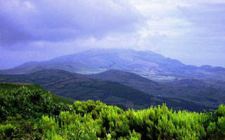 The Pico da Velha cone is seen in this view of the interior of the island of São Jorge. The linear island is 54 km long and only about 6 km wide at its widest point. This cone is one of many along a volcanic ridge down the axis of the island. Eruptions recorded since 1580 have produced lava flows that reached the ocean, and submarine eruptions were reported from vents off the southern and southwestern coasts.
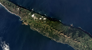 The 54-km-long and up to 6.5-km-wide San Jorge island is shown across this December 2018 Planet Labs satellite image monthly mosaic (N is at the top; this image is approximately 27 km across). The island has three main parts that compose the upper units across the island, with the Rosais Complex to the W, the Manadas Complex in the center, and the Topo complex in the E. The western two-thirds (mostly shown here) has fissure vents across the surface that produced lava flows and spatter ramparts.
There are no samples for São Jorge in the Smithsonian's NMNH Department of Mineral Sciences Rock and Ore collection.
| Copernicus Browser | The Copernicus Browser replaced the Sentinel Hub Playground browser in 2023, to provide access to Earth observation archives from the Copernicus Data Space Ecosystem, the main distribution platform for data from the EU Copernicus missions. |
| MIROVA | Middle InfraRed Observation of Volcanic Activity (MIROVA) is a near real time volcanic hot-spot detection system based on the analysis of MODIS (Moderate Resolution Imaging Spectroradiometer) data. In particular, MIROVA uses the Middle InfraRed Radiation (MIR), measured over target volcanoes, in order to detect, locate and measure the heat radiation sourced from volcanic activity. |
| MODVOLC Thermal Alerts | Using infrared satellite Moderate Resolution Imaging Spectroradiometer (MODIS) data, scientists at the Hawai'i Institute of Geophysics and Planetology, University of Hawai'i, developed an automated system called MODVOLC to map thermal hot-spots in near real time. For each MODIS image, the algorithm automatically scans each 1 km pixel within it to check for high-temperature hot-spots. When one is found the date, time, location, and intensity are recorded. MODIS looks at every square km of the Earth every 48 hours, once during the day and once during the night, and the presence of two MODIS sensors in space allows at least four hot-spot observations every two days. Each day updated global maps are compiled to display the locations of all hot spots detected in the previous 24 hours. There is a drop-down list with volcano names which allow users to 'zoom-in' and examine the distribution of hot-spots at a variety of spatial scales. |
|
WOVOdat
Single Volcano View Temporal Evolution of Unrest Side by Side Volcanoes |
WOVOdat is a database of volcanic unrest; instrumentally and visually recorded changes in seismicity, ground deformation, gas emission, and other parameters from their normal baselines. It is sponsored by the World Organization of Volcano Observatories (WOVO) and presently hosted at the Earth Observatory of Singapore.
GVMID Data on Volcano Monitoring Infrastructure The Global Volcano Monitoring Infrastructure Database GVMID, is aimed at documenting and improving capabilities of volcano monitoring from the ground and space. GVMID should provide a snapshot and baseline view of the techniques and instrumentation that are in place at various volcanoes, which can be use by volcano observatories as reference to setup new monitoring system or improving networks at a specific volcano. These data will allow identification of what monitoring gaps exist, which can be then targeted by remote sensing infrastructure and future instrument deployments. |
| Volcanic Hazard Maps | The IAVCEI Commission on Volcanic Hazards and Risk has a Volcanic Hazard Maps database designed to serve as a resource for hazard mappers (or other interested parties) to explore how common issues in hazard map development have been addressed at different volcanoes, in different countries, for different hazards, and for different intended audiences. In addition to the comprehensive, searchable Volcanic Hazard Maps Database, this website contains information about diversity of volcanic hazard maps, illustrated using examples from the database. This site is for educational purposes related to volcanic hazard maps. Hazard maps found on this website should not be used for emergency purposes. For the most recent, official hazard map for a particular volcano, please seek out the proper institutional authorities on the matter. |
| IRIS seismic stations/networks | Incorporated Research Institutions for Seismology (IRIS) Data Services map showing the location of seismic stations from all available networks (permanent or temporary) within a radius of 0.18° (about 20 km at mid-latitudes) from the given location of São Jorge. Users can customize a variety of filters and options in the left panel. Note that if there are no stations are known the map will default to show the entire world with a "No data matched request" error notice. |
| UNAVCO GPS/GNSS stations | Geodetic Data Services map from UNAVCO showing the location of GPS/GNSS stations from all available networks (permanent or temporary) within a radius of 20 km from the given location of São Jorge. Users can customize the data search based on station or network names, location, and time window. Requires Adobe Flash Player. |
| DECADE Data | The DECADE portal, still in the developmental stage, serves as an example of the proposed interoperability between The Smithsonian Institution's Global Volcanism Program, the Mapping Gas Emissions (MaGa) Database, and the EarthChem Geochemical Portal. The Deep Earth Carbon Degassing (DECADE) initiative seeks to use new and established technologies to determine accurate global fluxes of volcanic CO2 to the atmosphere, but installing CO2 monitoring networks on 20 of the world's 150 most actively degassing volcanoes. The group uses related laboratory-based studies (direct gas sampling and analysis, melt inclusions) to provide new data for direct degassing of deep earth carbon to the atmosphere. |
| Large Eruptions of São Jorge | Information about large Quaternary eruptions (VEI >= 4) is cataloged in the Large Magnitude Explosive Volcanic Eruptions (LaMEVE) database of the Volcano Global Risk Identification and Analysis Project (VOGRIPA). |
| EarthChem | EarthChem develops and maintains databases, software, and services that support the preservation, discovery, access and analysis of geochemical data, and facilitate their integration with the broad array of other available earth science parameters. EarthChem is operated by a joint team of disciplinary scientists, data scientists, data managers and information technology developers who are part of the NSF-funded data facility Integrated Earth Data Applications (IEDA). IEDA is a collaborative effort of EarthChem and the Marine Geoscience Data System (MGDS). |

