Portugal Volcanoes
A map display is currently under development.
Portugal has 13 Holocene volcanoes. Note that as a scientific organization we provide these listings for informational purposes only, with no international legal or policy implications. Volcanoes will be included on this list if they are within the boundaries of a country, on a shared boundary or area, in a remote territory, or within a maritime Exclusive Economic Zone. Bolded volcanoes have erupted within the past 20 years. Suggestions and data updates are always welcome ().
| Volcano Name | Last Eruption | Volcanic Region | Primary Landform |
|---|---|---|---|
| Agua de Pau | 1564 CE | Azores-Terceira Rift Volcanic Province | Composite |
| Don Joao de Castro Bank | 1720 CE | Azores-Terceira Rift Volcanic Province | Shield |
| Fayal | 1958 CE | Azores-Terceira Rift Volcanic Province | Composite |
| Flores | 950 BCE | Azores-Terceira Rift Volcanic Province | Composite |
| Furnas | 1630 CE | Azores-Terceira Rift Volcanic Province | Composite |
| Graciosa | 1950 BCE | Azores-Terceira Rift Volcanic Province | Composite |
| Madeira | 4500 BCE | Madeira Hotspot Volcano Group | Shield |
| Monaco Bank | 1911 CE | Azores-Terceira Rift Volcanic Province | Cluster |
| Pico | 1720 CE | Azores-Terceira Rift Volcanic Province | Composite |
| Picos Fissural Volcanic System | 1652 CE | Azores-Terceira Rift Volcanic Province | Cluster |
| Sao Jorge | 1902 CE | Azores-Terceira Rift Volcanic Province | Cluster |
| Sete Cidades | 1880 CE | Azores-Terceira Rift Volcanic Province | Composite |
| Terceira | 2000 CE | Azores-Terceira Rift Volcanic Province | Composite |
Chronological listing of known Holocene eruptions (confirmed or uncertain) from volcanoes in Portugal. Bolded eruptions indicate continuing activity.
| Volcano Name | Start Date | Stop Date | Certainty | VEI | Evidence |
|---|---|---|---|---|---|
| Terceira | 1998 Nov 25 (?) | 2000 Mar 16 (?) ± 15 days | Confirmed | 0 | Observations: Reported |
| Don Joao de Castro Bank | [1997 Jun 27] | [1997 Jul 16 (?) ± 15 days] | Uncertain | ||
| Sao Jorge | [1964 Feb 18] | [1964 Feb 18] | Uncertain | ||
| Pico | [1963 Dec 15 (on or before)] | [Unknown] | Uncertain | ||
| Fayal | 1957 Sep 27 | 1958 Oct 24 | Confirmed | 2 | Observations: Reported |
| Monaco Bank | 1911 Mar 7 | Unknown | Confirmed | 1 | Observations: Reported |
| Monaco Bank | 1907 Apr 1 | Unknown | Confirmed | 0 | Observations: Reported |
| Sao Jorge | 1902 May 7 | 1902 May 8 | Confirmed | 0 | Observations: Reported |
| Sete Cidades | 1880 | Unknown | Confirmed | 0 | Unknown |
| Terceira | 1867 Jun 1 | 1867 Jun 8 | Confirmed | 3 | Observations: Reported |
| Sete Cidades | 1861 | Unknown | Confirmed | 0 | Unknown |
| Sete Cidades | 1811 Jun 14 | 1811 Jun 22 | Confirmed | 3 | Observations: Reported |
| Sete Cidades | 1811 Feb 1 | 1811 Feb 8 | Confirmed | 2 | Observations: Reported |
| Sao Jorge | 1808 May 1 | 1808 Jun 10 | Confirmed | 1 | Observations: Reported |
| Sao Jorge | 1800 Jun 24 | 1800 Jun 25 | Confirmed | 2 | Observations: Reported |
| Terceira | 1761 Apr 17 | 1761 Apr 28 (?) | Confirmed | 2 | Observations: Reported |
| Don Joao de Castro Bank | 1720 Dec 8 (?) | 1720 Dec 26 ± 5 days | Confirmed | 3 | Observations: Reported |
| Pico | 1720 Jul 10 | 1720 Dec (?) | Confirmed | 2 | Observations: Reported |
| Pico | 1718 Feb 1 | 1718 Dec 15 ± 5 days | Confirmed | 2 | Observations: Reported |
| Sete Cidades | 1713 | Unknown | Confirmed | 2 | Observations: Reported |
| Sete Cidades | 1682 Dec 13 | Unknown | Confirmed | 2 | Observations: Reported |
| Fayal | 1672 Apr 24 | 1673 Feb 28 | Confirmed | 2 | Observations: Reported |
| Picos Fissural Volcanic System | 1652 Oct 19 | 1652 Oct 26 | Confirmed | 2 | Observations: Reported |
| Sete Cidades | 1638 Jul 3 | 1638 Jul 28 | Confirmed | 2 | Observations: Reported |
| Furnas | 1630 Sep 3 | 1630 Nov 2 | Confirmed | 5 | Observations: Reported |
| Sao Jorge | 1580 May 1 | 1580 Aug 30 (?) | Confirmed | 3 | Observations: Reported |
| Agua de Pau | 1564 Feb 10 | 1564 Feb 12 | Confirmed | 2 | Observations: Reported |
| Agua de Pau | 1563 Jun 28 | 1563 Jul 26 ± 5 days | Confirmed | 5 | Observations: Reported |
| Pico | 1562 Sep 21 (?) | 1564 (?) | Confirmed | 2 | Observations: Reported |
| Sao Jorge | 1483 | Unknown | Confirmed | Isotopic: 14C (calibrated) | |
| Sete Cidades | 1444 (?) | Unknown | Confirmed | 4 | Observations: Reported |
| Furnas | 1441 ± 2 years | Unknown | Confirmed | 4 | Observations: Reported |
| Furnas | 1430 ± 100 years | Unknown | Confirmed | 3 | Isotopic: 14C (uncalibrated) |
| Sao Jorge | 1426 | Unknown | Confirmed | Isotopic: 14C (calibrated) | |
| Terceira | 1400 ± 50 years | Unknown | Confirmed | Correlation: Tephrochronology | |
| Sao Jorge | 1293 | Unknown | Confirmed | Isotopic: 14C (calibrated) | |
| Sao Jorge | 1282 | Unknown | Confirmed | Isotopic: 14C (calibrated) | |
| Terceira | 1200 ± 300 years | Unknown | Confirmed | Correlation: Tephrochronology | |
| Furnas | 1170 ± 100 years | Unknown | Confirmed | 4 | Isotopic: 14C (uncalibrated) |
| Sete Cidades | 1110 ± 50 years | Unknown | Confirmed | 2 | Isotopic: 14C (uncalibrated) |
| Sete Cidades | 0950 ± 100 years | Unknown | Confirmed | 2 | Isotopic: 14C (uncalibrated) |
| Picos Fissural Volcanic System | 0940 ± 100 years | Unknown | Confirmed | Isotopic: 14C (uncalibrated) | |
| Terceira | 0920 ± 50 years | Unknown | Confirmed | Isotopic: 14C (uncalibrated) | |
| Picos Fissural Volcanic System | 0850 ± 150 years | Unknown | Confirmed | Isotopic: 14C (uncalibrated) | |
| Furnas | 0840 ± 100 years | Unknown | Confirmed | 4 | Isotopic: 14C (uncalibrated) |
| Terceira | 0820 ± 40 years | Unknown | Confirmed | Isotopic: 14C (uncalibrated) | |
| Agua de Pau | 0700 ± 150 years | Unknown | Confirmed | Isotopic: 14C (uncalibrated) | |
| Sete Cidades | 0670 ± 150 years | Unknown | Confirmed | 3 | Isotopic: 14C (uncalibrated) |
| Picos Fissural Volcanic System | 0600 ± 100 years | Unknown | Confirmed | Isotopic: 14C (uncalibrated) | |
| Sao Jorge | 0412 | Unknown | Confirmed | Isotopic: 14C (calibrated) | |
| Sete Cidades | 0380 ± 300 years | Unknown | Confirmed | 4 | Correlation: Tephrochronology |
| Terceira | 0190 ± 40 years | Unknown | Confirmed | Isotopic: 14C (uncalibrated) | |
| Agua de Pau | 0160 ± 150 years | Unknown | Confirmed | Isotopic: 14C (uncalibrated) | |
| Sete Cidades | 0090 ± 100 years | Unknown | Confirmed | 4 | Isotopic: 14C (uncalibrated) |
| Furnas | 0080 ± 100 years | Unknown | Confirmed | 5 | Isotopic: 14C (uncalibrated) |
| Terceira | 0070 ± 40 years | Unknown | Confirmed | Isotopic: 14C (uncalibrated) | |
| Terceira | 0060 BCE (?) | Unknown | Confirmed | Isotopic: 14C (uncalibrated) | |
| Terceira | 0090 BCE ± 100 years | Unknown | Confirmed | Isotopic: 14C (uncalibrated) | |
| Furnas | 0360 BCE ± 150 years | Unknown | Confirmed | Isotopic: 14C (uncalibrated) | |
| Picos Fissural Volcanic System | 0510 BCE ± 200 years | Unknown | Confirmed | Isotopic: 14C (uncalibrated) | |
| Terceira | 0670 BCE ± 300 years | Unknown | Confirmed | Isotopic: 14C (uncalibrated) | |
| Sete Cidades | 0750 BCE ± 300 years | Unknown | Confirmed | Isotopic: 14C (uncalibrated) | |
| Picos Fissural Volcanic System | 0850 BCE ± 100 years | Unknown | Confirmed | Isotopic: 14C (uncalibrated) | |
| Terceira | 0940 BCE ± 50 years | Unknown | Confirmed | Isotopic: 14C (uncalibrated) | |
| Flores | 0950 BCE ± 100 years | Unknown | Confirmed | Isotopic: 14C (uncalibrated) | |
| Flores | 1200 BCE ± 100 years | Unknown | Confirmed | Isotopic: 14C (uncalibrated) | |
| Agua de Pau | 1290 BCE (?) | Unknown | Confirmed | 4 | Isotopic: 14C (uncalibrated) |
| Furnas | 1670 BCE ± 1460 years | Unknown | Confirmed | Correlation: Tephrochronology | |
| Agua de Pau | 1850 BCE ± 500 years | Unknown | Confirmed | 3 | Isotopic: 14C (uncalibrated) |
| Graciosa | 1950 BCE ± 1400 years | Unknown | Confirmed | Isotopic: Ar/Ar | |
| Sete Cidades | 2050 BCE ± 1000 years | Unknown | Confirmed | Correlation: Tephrochronology | |
| Sao Jorge | 2137 BCE | Unknown | Confirmed | Isotopic: 14C (calibrated) | |
| Agua de Pau | 2210 BCE ± 150 years | Unknown | Confirmed | Isotopic: 14C (uncalibrated) | |
| Terceira | 2530 BCE ± 40 years | Unknown | Confirmed | Isotopic: 14C (uncalibrated) | |
| Agua de Pau | 2990 BCE (?) | Unknown | Confirmed | 5 | Isotopic: 14C (uncalibrated) |
| Sete Cidades | 3050 BCE (?) | Unknown | Confirmed | 4 | Correlation: Tephrochronology |
| Picos Fissural Volcanic System | 4040 BCE (?) | Unknown | Confirmed | Isotopic: 14C (uncalibrated) | |
| Madeira | 4500 BCE ± 50 years | Unknown | Confirmed | Isotopic: 14C (calibrated) | |
| Agua de Pau | 4550 BCE ± 100 years | Unknown | Confirmed | Isotopic: 14C (uncalibrated) | |
| Furnas | 4570 BCE (in or before) | Unknown | Confirmed | Isotopic: 14C (uncalibrated) | |
| Terceira | 6720 BCE ± 50 years | Unknown | Confirmed | Isotopic: 14C (uncalibrated) | |
| Agua de Pau | 6750 BCE ± 200 years | Unknown | Confirmed | Isotopic: 14C (uncalibrated) |
Portugal has 1 Pleistocene volcanoes. Note that as a scientific organization we provide these listings for informational purposes only, with no international legal or policy implications. Volcanoes will be included on this list if they are within the boundaries of a country, on a shared boundary or area, in a remote territory, or within a maritime Exclusive Economic Zone. Suggestions and data updates are always welcome ().
| Volcano Name | Volcanic Region | Primary Landform |
|---|---|---|
| Corvo | Western European Volcanic Province | Composite |
There are 50 photos available for volcanoes in Portugal.
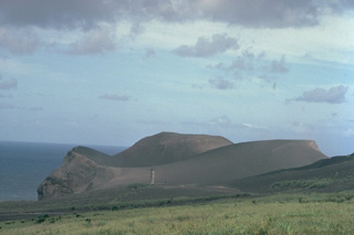
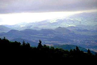
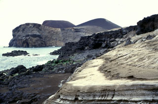 The eroded pyroclastic cone at the left, now forming the western tip of Fayal Island, was constructed during the 1957-58 Capelinhos eruption. Submarine eruptions formed an island that was later joined to the mainland, creating a 1-km-wide peninsula. Wave erosion soon truncated the sides of the new cone, forming the steep south-facing cliffs seen here. Beach erosion in the foreground exposes light-colored ashfall deposits from the eruption.
Photo by Rick Wunderman, 1997 (Smithsonian Institution).
 Terceira Island contains four stratovolcanoes constructed along a prominent ESE-WNW-trending fissure zone that cuts across the island. Historically active Santa Barbara volcano at the western end of the island is truncated by two Pleistocene calderas. The caldera is filled and surrounded by comenditic lava domes, such as the one at the right, which is located east of the caldera. Historical eruptions have occurred from Pico Alto stratovolcano, the fissure zone between it and Santa Barbara, and from submarine vents west of Santa Barbara.
 Copyrighted photo by Katia and Maurice Krafft, 1980.
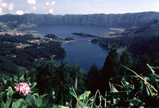
 The SE floor of Sete Cidades caldera contains a large trachytic lava dome with two craters containing Lagoa de Santiago and Lagoa Rasa. The rim of Lagoa de Santiago crater is visible in the center. The visible lakes in this image are the Lagoa Verde (left foreground) and Lagoa Azul (left background), that occupy much of the caldera floor. Both explosive eruptions forming Santiago and Rasa occurred within the last 5,000 years.
Photo by Rick Wunderman, 1997 (Smithsonian Institution).
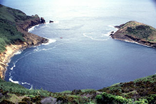 The crater of Monte da Guia tuff cone at the SE tip of Fayal Island has been breached by the sea, forming a circular bay measuring about 500 m long. This view looks out to sea from the NW rim of the cone, which was formed by phreatomagmatic eruptions produced when magma encountered water along the coast. A small boat used by divers provides scale off the headland at left center.
Photo by Rick Wunderman, 1997 (Smithsonian Institution).
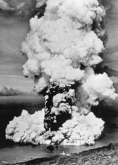 A column of ash and steam rises above a new submarine vent off the western coast of Fayal Island in early October 1957. Horizontally traveling base surges form a ring at the base of the eruption column. Explosive eruptions began on September 27 and formed a small island that eventually was joined to the main island, partially burying the Capelinhos lighthouse, which is visible on the center shoreline (bottom). Lava effusion was continuous for the last five months of the 13-month eruption.
Photo by U.S. Air Force, 1957 (published in Green and Short, 1971).
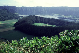
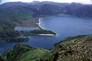
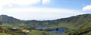
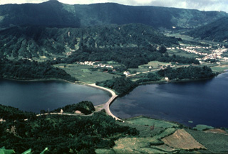
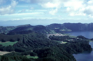
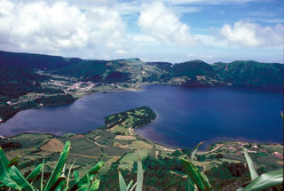 A small peninsula extends into Lagoa Azul ("Blue Lake"), one of two main lakes partially filling the floor of the summit caldera on Sete Cidades volcano at the western end of Sao Miguel Island. The 5-km-wide caldera was formed in three major eruptions at about 36,000, 29,000 and 16,000 years ago, and at least 17 eruptions have occurred here in the last 5,000 years. This view looks to the northwest from the rim of a post-caldera cone containing Lagoa Santiago. Two other post-caldera cones, Caldeira do Alferes and Seara, lie across the lake, behind and to the right of the town of Sete Cidades.
Photo by R.V. Fisher, 1980 (University of California Santa Barbara).
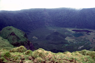
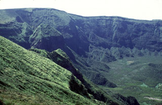 The steep vegetated northwest wall of the 2-km-wide summit caldera of Fayal volcano rises about 400 m above the caldera floor. A small pyroclastic cone is visible at the lower right. It is thought that this caldera formed in stages, beginning with a large explosive eruption about 1,000 years ago.
Photo by Rick Wunderman, 1997 (Smithsonian Institution).
 Cabeço Verde (left center) and Cabeço do Canto (center) are two pyroclastic cones along a linear chain of volcanoes that form the western peninsula of Fayal Island. Lava flows from these cones flowed into the sea on the northern and southern coasts during the 1672-73 eruption.
 Photo by Rick Wunderman, 1997 (Smithsonian Institution).
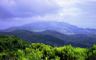
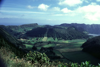
 The forested ridge in the center of the photo is part of the northern rim of the approximately 3.2 km diameter inner Agua de Pau caldera, which formed at the beginning of the Holocene, in an eruption dated to between 12,000 and 8,000 years ago. The Serra de Agua de Pau hills in the background mark the northern rim of an outer late Pleistocene caldera. The Lagoa de Fogo caldera lake (lower right) partially fills the inner caldera.
Photo by Rick Wunderman, 1997 (Smithsonian Institution).
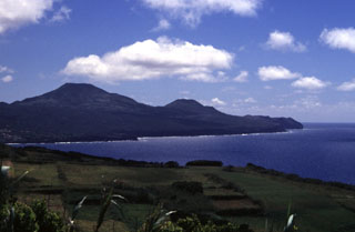
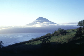
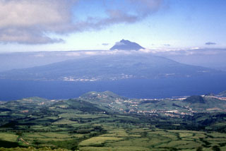 The conical Pico stratovolcano rising above the clouds is seen here from Fayal Island to the northwest. The 46-km-long Pico Island can be broadly separated into the Pico stratovolcano in the west, the Planalto da Achada fissure zone in the east (a roughly 30-km-long linear ridge of fissures and cones), and the Topo-Lajes volcano in the south. Pico volcano is capped by a 560-m-wide summit crater that contains a small steep-sided cone visible on the left side of the summit in this image. Recent eruptions have been recorded from the flanks of Pico and in the Planalto da Achada fissure zone.
 Photo by Rick Wunderman, 1997 (Smithsonian Institution).
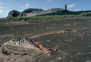
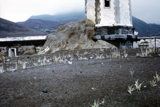
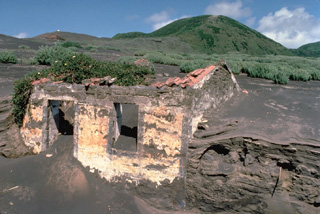 Accumulated thin layers of ashfall deposits reach nearly to the roofline at both gable ends of a house on the western tip of Fayal Island. Repetitive, long-term ashfall during a 1957-58 eruption built an offshore cinder cone that added 1 km to the island's western peninsula.
Copyrighted photo by Katia and Maurice Krafft, 1980.
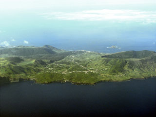 The south of Graciosa island is seen in this aerial view from the southwest. The village of Luz is at the center of the image. On the right (the southeast end of the island), is the 0.9 x 1.5 km Vulcão Central caldera, which formed between 60,000 and 11,000 years ago; the caldera rim forms the highest point of the 7 x 12 km island. The lava cave Furna Do Enzofre is situated in the southeastern part of the caldera, and exhibits fumarolic activity. Vegetated volcanic cones and part of the approximately 700,000 year old Serra das Fontes complex can be seen in the left of the photo.
Photo by Angrense, 2007 (Wikimedia Commons).
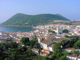
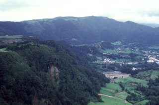 The village of Furnas (right) lies in the center of Furnas caldera, whose northern rim forms the ridge in the background. The largest eruption in the last 5,000 years originated at a vent where the village is now located. This Plinian eruption, named Furnas C, occurred about 1,900 years ago. Activity varied between phreatomagmatic and magmatic styles, producing massive fallout of pumice and ash and pyroclastic flows and surges.
Photo by Rick Wunderman, 1997 (Smithsonian Institution).
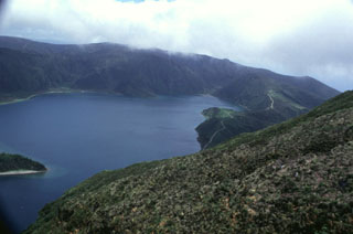
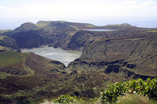 Lakes occupy Caldeira Funda (left) and Caldeira Rasa (right) on SW Flores Island in this view from the east. The Caldeira Funda de Lajes tuff ring formed about 3,150 years ago, accompanied by a lava flow that reached the coast to the southeast. The 12 x 17 km island of Flores has numerous cones and craters.
Photo by Björn Ehrlich, 2007 (Wikipedia).
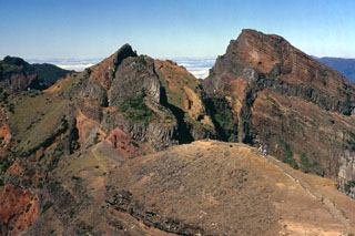 The rugged summit of Pico Ruvio forms the high point of the island of Madeira. This eroded scoria cone complex was erupted during Pliocene-to-Pleistocene rift activity along the axis of the Madeira rift. Dense swarms of dikes, some of which are visible in this image (dark gray bands), are oriented E-W, parallel to the orientation of the rift.
Photo by Paul Bernhardt.
 Fayal volcano is capped by a 2-km-wide, 400-m-deep summit caldera, seen here from its southern rim. A small pyroclastic cone (center) and a dark lake (right) can be seen on the floor of the caldera. The caldera was formed incrementally, beginning with a large eruption about 1,000 years ago. Thick airfall-pumice and pyroclastic-flow deposits related to this eruption cover the island.
Photo by Rick Wunderman, 1997 (Smithsonian Institution).
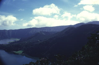
 Furnas volcano, at the eastern end of Sao Miguel Island, contains two nested calderas. The southern rim of the younger 6-km-wide caldera is seen here from the north, with Furnas Lake on the right foreground. At least 10 trachytic pumice layers, all erupted during the past 5,000 years, post-date the caldera. The dome with the semi-circle of trees in the center behind the lake is the site of the most recent eruption at Furnas, a sub-Plinian eruption in 1630 CE.
Photo by Rick Wunderman, 1997 (Smithsonian Institution).
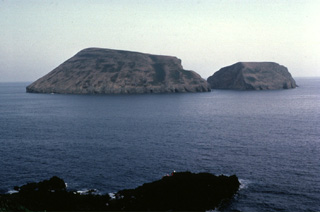 The Ilheus das Cabras islands are the remnants of a tuff cone located 2 km off the southern coast of Terceira Island. Only the northern half of the tuff cone remains above sea level. The cone has been eroded into two small islands separated by a narrow channel. The crater of the tuff cone faces south and is obscured from this view taken west of Ponta da Cruz on the SE coast of Terceira.
Copyrighted photo by Katia and Maurice Krafft, 1980.
 A submarine eruption that began off the western coast of Fayal Island in 1957 produced heavy ashfall that buried houses, such as the one in the foreground. The new submarine vent built a pyroclastic cone (upper left) that was eventually connected to the mainland. Extensive ashfall partially buried the Capelinhos lighthouse (upper right), which had been located on the western shoreline of Fayal Island.
Copyrighted photo by Katia and Maurice Krafft, 1980.
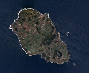
 In the Azores archipelago west of the Mid-Atlantic Ridge is the 12 x 17 km Flores Island, shown in this February 2018 Planet Labs satellite image monthly mosaic (N is at the top). Initially a submarine volcano, the island formed through the eruption of different vents, forming cones, craters, maars, and associated eruption products like lava flows.
Satellite image courtesy of Planet Labs Inc., 2019 (https://www.planet.com/).
 The Pico da Velha cone is seen in this view of the interior of the island of São Jorge. The linear island is 54 km long and only about 6 km wide at its widest point. This cone is one of many along a volcanic ridge down the axis of the island. Eruptions recorded since 1580 have produced lava flows that reached the ocean, and submarine eruptions were reported from vents off the southern and southwestern coasts.
Photo by Luís A. da Silveira, 2007 (Wikimedia Commons).
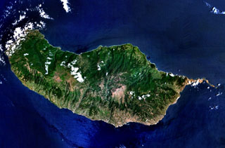 The 90-km-long island of Madeira is seen in this NASA Landsat image (with north to the top). Construction of the volcano along E-W-trending rift zones was followed by a period of extensive erosion and possible edifice collapse. The capital city of Funchal lies along the SE coast, east of a large caldera that extends to the southern coast. Late-stage eruptions were scattered throughout the island, although the youngest activity took place along the west-central crest of the island, on the Paul da Serra plateau near the cloud near the center of this image.
 NASA Landsat 7 image (worldwind.arc.nasa.gov)
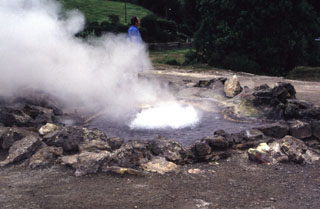 Hydrothermal features at Furnas include several fields of fumaroles, hot springs, bubbling pools and mudpits, and the emission of carbon dioxide both at springs and through the soil. Fumarole fields are found on the north shore of Furnas Lake, in the river gorge of the Ribeira Quente, the Ribeira Quente village on the coast outside of the caldera, and in the upper Ribeira dos Tambores. A significant fumarole field, including the hot spring seen here, is located in the main fumarole field, Caldeiras das Furnas, in the village of Furnas.
Photo by Rick Wunderman, 1997 (Smithsonian Institution).
 The inner Agua de Pau caldera, seen here from the western caldera rim, is now partially filled by Lagoa do Fogo caldera lake. The caldera was the source of a major explosive eruption about 4,600 years ago that deposited tephra layer Fogo A, and marked the renewal of explosive activity within the approximately 12,000-year-old caldera. The eruption also produced massive pyroclastic flows across most of the volcano’s flanks.
Photo by Rick Wunderman, 1997 (Smithsonian Institution).
 The tree lined, approximately 500 x 700 m, Caldeira Seca pumice ring (center) on the floor of the Sete Cidades caldera, with Lagoa Azul and the northeast wall of the caldera in the background. The southeastern flank of the Calderia do Alferes is seen in the upper left. Caldeira Seca formed during a 15th-century phreatomagmatic eruption in which large amounts of pumice ash, lapilli and blocks were erupted.
Photo by Rick Wunderman, 1997 (Smithsonian Institution).
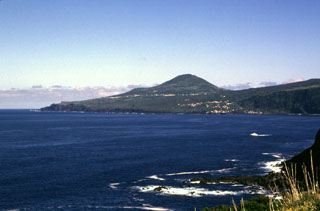
 Pico volcano, the highest in the Azores, is located across a narrow 6-km-wide channel southeast of Fayal Island. From this direction, the stratovolcano appears to be a symmetrical cone, but it lies at the far western end of an elongated chain of cones that forms a roughly 800-m-high ridge extending ESE across Pico Island. Fumaroles are located near a small cone filling the summit crater, but eruptions recorded since 1562 CE have all occurred from flank vents.
Photo by Rick Wunderman, 1997 (Smithsonian Institution).
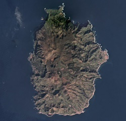
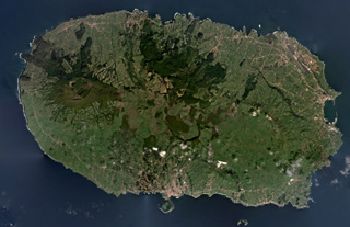
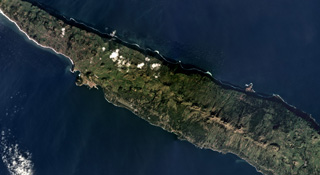 The 54-km-long and up to 6.5-km-wide San Jorge island is shown across this December 2018 Planet Labs satellite image monthly mosaic (N is at the top; this image is approximately 27 km across). The island has three main parts that compose the upper units across the island, with the Rosais Complex to the W, the Manadas Complex in the center, and the Topo complex in the E. The western two-thirds (mostly shown here) has fissure vents across the surface that produced lava flows and spatter ramparts.
Satellite image courtesy of Planet Labs Inc., 2019 (https://www.planet.com/).
 Lagoa do Fogo, seen here from the west, partially fills the younger of two Pleistocene calderas on Agua de Pau stratovolcano in central Sao Miguel Island. The walls of the caldera surrounding the lake rise to a maximum of about 370 m above the surface. Eruptions have occurred both inside the caldera and on the flanks, where multiple cones and domes can be found. Two major explosive eruptions have occurred in the Holocene from the caldera: the Ribeira Cha (8,000 to 12,000 years ago) and Fogo A (about 4,600 years ago).
 Photo by Rick Wunderman, 1977 (Smithsonian Institution).
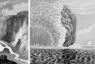 This 19th-century sketch shows a submarine eruption during 1811 off the western coast of Sao Miguel Island in the Azores. Lightning flashes appear at the base of the eruption column, which consists of both a light-colored steam cloud and a darker, ash-laden eruption plume. Explosive eruptions took place February 1-8 and June 16-22, 1811 from the submarine vent. The June eruptions formed an ephemeral island named Sabrina that at its peak stage of growth was 2-km long and 90-m high.
From the collection of Maurice and Katia Krafft.
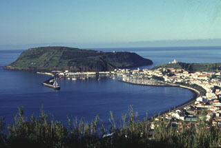 The Monte da Guia tuff cone forms a backdrop to the harbor of Horta, the largest town on the island of Fayal. The cone was formed by phreatomagmatic eruptions just off the SE tip of the island and is now connected to Fayal by a low narrow peninsula. It is one of a cluster of cones on the lower SE flank. These cones and an associated basaltic lava field form the late Pleistocene Almoxarife Formation.
Photo by Rick Wunderman, 1997 (Smithsonian Institution).
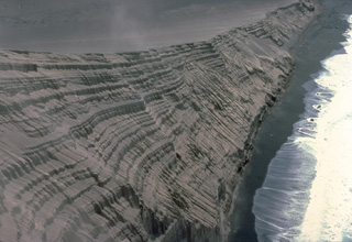 The new pyroclastic cone formed during the 1957-58 Capelinhos eruption has been extensively eroded by the sea, exposing this cross-section of the cone. The thick stack of tephra layers formed by fallout of pyroclastic material during individual eruptive pulses illustrates the process by which pyroclastic cones grow. Initial eruptions were submarine, but these tephra layers were formed by subaerial eruptions after the vent rose above sea level.
Copyrighted photo by Katia and Maurice Krafft, 1980.
 The summit caldera of Sete Cidades volcano at the western end of Sao Miguel Island contains two lakes and is one of the scenic highlights of the Azores. A nearly circular ring of six Holocene pyroclastic cones occupies the floor of the 5-km-wide caldera and has been the source of a dozen major explosive eruptions during the past 5000 years. Sete Cidades is one of the most active Azorean volcanoes. Historical eruptions date back to the 15th century and have occurred from within the caldera and from submarine vents off the west coast.
 Copyrighted photo by Katia and Maurice Krafft, 1980.
 Four main volcanic centers form the 29-km-wide Terceira Island shown in this February 2020 Planet Labs satellite image monthly mosaic (N is at the top). The Santa Barbara edifice with the summit caldera is to the W, with lava domes and coulées both in the caldera and on the flanks, concealing an older caldera on the NE flank. The Pico Alto complex is at the north of the center of the island and to the south of that is the Guilherme Moniz caldera. The NE and SW Cinco Picos caldera rims are exposed on the SE side of the island, with the São Sebastião crater near the SE boundary.
Satellite image courtesy of Planet Labs Inc., 2020 (https://www.planet.com/).
 Lagoa do Fogo ("Fire Lake") is seen here from the northwest caldera rim of Agua de Pau. A Plinian eruption from the central caldera began on 28 June 1563, depositing trachytic pumice predominantly eastward over the island. On 2 July an eruption began on the northwest flank, producing a lava flow that reached the northern coast at Ribeira Grande.
Photo by Rick Wunderman, 1997 (Smithsonian Institution).
 Pyroclastic surge, or base surge deposits from the 1957 phreatomagmatic Capelinhos eruption lap up against a lighthouse near the western coast of Fayal Island in the Azores. Pyroclastic surges produced by magma-water interaction during the Surtseyan eruption nearly buried the lower floor of the lighthouse building. The initially submarine eruption began off the western tip of Fayal, forming a small island that was eventually joined to the main island.
 Photo by R.V. Fisher, 1979 (University of California Santa Barbara).
 A public fountain at Ribeira Grande on the northern coast of San Miguel Island was buried by a lava flow that was erupted from Agua de Pau volcano in 1563. The lava flow originated during the Pico do Sapateiro eruption, which began on 2 July when vents formed across the Queimado dome on the NW flank, generating an eruption column with blocks and bombs. The flank eruption was preceded by a major Plinian eruption from the central caldera that began on 28 June and deposited trachytic pumice dominantly eastward over the island; the summit eruption ended a day after the flank activity began.
Photo by Rick Wunderman, 1997 (Smithsonian Institution).
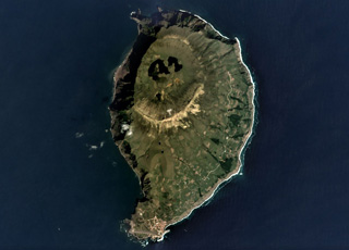
 Agricultural fields line much of the walls of a 2-km-wide caldera on the northwest side of Corvo Island. The walls reach about 200 m above the caldera floor, which contains several small, vegetated cinder cones and two shallow lakes. The 4 x 6 km island is located at the NW end of the Azores archipelago, west of the Mid-Atlantic Ridge. The Vila do Corvo flank eruption is the youngest known activity, dated about 80,000 years ago; it produced a lava flow that reached the ocean on the southern tip of the island.
Photo by Argense, 2007 (Wikimedia Commons).
 Caldeira do Alferes (center) is one of a group of pyroclastic cones constructed on the floor of Sete Cidades caldera. The adjacent cone of Seara is just visible in the background, right of Caldeira do Alferes in this view from the western caldera rim. The forested slope seen in the right foreground is Caldeira Seca. Explosive trachytic eruptions occurred at least 17 times in the past 5,000 years within the caldera.
 Photo by Rick Wunderman, 1997 (Smithsonian Institution).
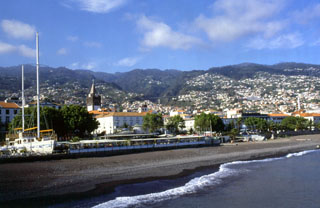 Funchal, the capital city of Madeira, is seen here along the southeast flanks of the massive shield volcano forming the island. The island is the emergent summit of a volcano that rises about 6 km from the seafloor in an E-W-trending rift zone. Following a period of extensive erosion, renewed eruptions produced cinder cones and lava flows that traveled down dissected valleys.
Photo by Paul Bernhardt.
 The gentle slope along the right horizon is covered by lava flows that formed during the 1672-73 eruption. This eruption occurred along a WNW-ESE-trending ridge forming a wedge-shaped peninsula at the western tip of the island. Cabeço Verde (center), seen here from the SE, is one of a chain of pyroclastic cones that were constructed along the axis of the peninsula during the eruption. The most recent eruption at Fayal started in 1957 and occurred at the end of this peninsula.
Photo by Rick Wunderman, 1997 (Smithsonian Institution).
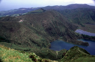
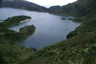
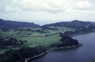
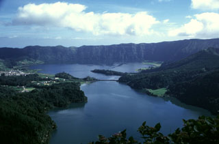 The 5-km-wide Sete Cidades caldera, seen from the southern rim, with lakes Lagoa Verde (foreground) and Lagoa Azul (background) that occupy much of the central caldera floor. To the east (right) and west (left) of these lakes are several pyroclastic cones that have formed in explosive eruptions during the last 5,000 years.
Photo by Rick Wunderman (Smithsonian Institution).
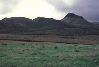
 The Monte Brasil pyroclastic cone is seen here beyond the city of Angra do Heroísmo on the south-central coast of Terceira Island. The 1.4 km wide cone is attached to the island by a small peninsula, and is related to the activity of the Guilherme Moniz volcano, which occupies the center of Terceira.
Photo by Luís A. da Silveira, 2007 (Wikimedia Commons).
 A highway bridge spans the junction of Lagoa Verde (left) and Lagoa Azul (right) lakes on the floor of Sete Cidades caldera. The erosionally furrowed wall of Caldeira Seca, the youngest of a circular group of post-caldera pyroclastic cones constructed within 5-km-wide Sete Cidades caldera, rises beyond the two lakes. The town of Sete Cidades (upper right) occupies the caldera floor between Caldeira Seca and another youthful pumice cone, Caldeira do Alferes.
Copyrighted photo by Katia and Maurice Krafft, 1980.
 The 4 x 6 km Corvo island of the Azores archipelago is shown in this September 2019 Planet Labs satellite image monthly mosaic (N is at the top). The northern half of the island contains the O Caldeirão caldera and the western coast is composed of cliffs. A scoria cone that opens towards the S is visible below the center of this image, and several other cones and lava flows are across the lower half of the island.
Satellite image courtesy of Planet Labs Inc., 2019 (https://www.planet.com/).
 A pyroclastic cone initially built by submarine eruptions during 1957-58 now forms a peninsula at the western tip of Fayal Island. The top of the lighthouse, which was located along the former shoreline, is visible at the lower left-center of the photo. Heavy ashfall from the eruption covered several houses and partially buried the lighthouse. Within the first two weeks of the eruption, an 800-m-wide island was built up to 100 m above sea level.
 Copyrighted photo by Katia and Maurice Krafft, 1980.
 A chain of scoria cones known as the Picos Fissural Volcanic System encompasses Sao Miguel Island between Sete Cidades and Agua de Pau volcanoes, seen in this view from the east below the Agua de Pau (Lagoa do Fogo) caldera. Scoria cones are the dominant volcanic form in the system, and over 270 are recognized here. The southern coast of Sao Miguel appears in the background. About 30 eruptions have occurred during the past 5,000 years, including eruptions in 1563 and 1652.
Copyrighted photo by Marco Fulle, 2000 (Stromboli On-Line, http://stromboli.net).
 The western section of the Sete Cidades caldera is seen in this view from the southern caldera rim. Lagoa Verde (bottom right) and Lagoa Azul (center right) stretch across the center of the caldera, bounded to the east and west by pyroclastic cones. Here, three forested cones can be seen that formed during the past 5,000 years. These are the Caldeira Seca (left), Caldeira do Alferes (left center), and Seara (behind and to the right of Alferes). The broadly circular caldera forms the horizon in the background.
Photo by Rick Wunderman, 1997 (Smithsonian Institution).
 The low hill covered by fields (left center) is Pico do Gaspar lava dome, surrounded by a low tuff cone. The Lagoa das Furnas lies to the west (right) and the eastern caldera wall can be seen in the left background. The Pico do Gaspar dome has been the site of two eruptions, including in about 1439-1443 CE; descriptions suggest an initial explosive phase producing ash, followed by lava dome formation.
 Photo by Rick Wunderman, 1997 (Smithsonian Institution).
 The roughly 7 x 12 km Graciosa island in the Azores archipelago has a 1.2 x 1.9 km caldera at the SE end, shown in this April 2019 Planet Labs satellite image monthly mosaic (N is at the top). The NW area contains scoria cones, many that have undergone flank collapse or rafting during Strombolian eruptions leaving an amphitheater shape, and lava flows. The growth of the island has been disrupted by multiple major flank collapse events through time.
Satellite image courtesy of Planet Labs Inc., 2019 (https://www.planet.com/).
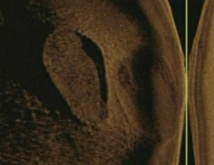 This side-viewing sonar image shows two 45 x 90 m craters on the NW flank of Don Joao de Castro Bank in the Azores taken by U.S. Navy submarine NR-1. The younger left crater displays a floor consisting of a chilled lava lake with polygonal surface fractures. The right crater is much less distinct because its surface is obscured by tephra deposits. The line at the right is the center track line of the sonar image.
U. S. Navy image courtesy of Rick Wunderman, 2003 (Smithsonian Institution).
This is a compilation of Portugal volcano information sources, such as official monitoring or other government agencies.
| Volcano Observatories | |
|---|---|
| Centro de Informação e Vigilância Sismovulcânica dos Açores (CIVISA) | |
| Instituto de Investigação em Vulcanologia e Avaliação de Riscos (IVAR) | |
| Civil Protection Agencies | |
|---|---|
| Serviço Regional de Proteção Civil e Bombeiros dos Açores | |
| Sindicato Nacional da Proteção Civil (SNPC) | |
| Volcanic Ash Advisory Center | |
|---|---|
| Toulouse Volcanic Ash Advisory Center (VAAC) Notices and Archive | |