Report on Santa Maria (Guatemala) — November 1990

Bulletin of the Global Volcanism Network, vol. 15, no. 11 (November 1990)
Managing Editor: Lindsay McClelland.
Santa Maria (Guatemala) Explosions and pyroclastic flows; four killed in July blast; lava flow; lahars to 50 km
Please cite this report as:
Global Volcanism Program, 1990. Report on Santa Maria (Guatemala) (McClelland, L., ed.). Bulletin of the Global Volcanism Network, 15:11. Smithsonian Institution. https://doi.org/10.5479/si.GVP.BGVN199011-342030
Santa Maria
Guatemala
14.757°N, 91.552°W; summit elev. 3745 m
All times are local (unless otherwise noted)
"Interpretation of telemetered seismic data by volcanologists at INSIVUMEH indicates a general increase in volcanic activity (pyroclastic eruptions, rock avalanches, and lava flows) at Caliente vent from June 1988 through August 1990 (figure 15). Five periods of increased lava flow activity have been documented, the most recent beginning in July 1990 (BGVN 15:06) and continuing as of early December. The number of explosions ranges from about 5 to 90 daily, while rock avalanches are more abundant, with 100 to as many as 600/day. Explosions, rock avalanches, and lava flow flux at the dome were greatest from June through September 1988, 1989, and 1990, corresponding to the rainy season. Small decreases in explosions and avalanches were noted during mid-October through March 1988-89, 1989-90, and from October through November 1990, and are roughly correlative with the dry season in Guatemala, suggesting a link between eruptive and climatic patterns at Santiaguito.
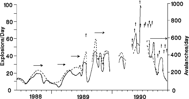 |
Figure 15. Appoximate number of daily explosions (solid line) and rock avalanches (dashed line) recorded by seismic stations near Santiaguito, June 1988-23 November 1990. Five periods of relatively high lava flow flux are marked by horizontal arrows. Vertical arrows mark dates of major pyroclastic eruptions. [Courtesy of Otoniel Matías.] |
"Beginning in April 1990, more than 20 powerful pyroclastic eruptions, similar in magnitude to the 19 July 1989 eruption, have occurred at Caliente vent (table 1). Direct observation of pyroclastic eruptions is often impossible because of weather conditions, but reports from four events indicate that they are characterized by large eruption columns rising 4-5.5 km above the vent, durations on the order of 7-15 minutes, and are heard as far away as Retalhuleu [25 km SSW]. Simultaneous collapse of a small plug dome atop Caliente generates pyroclastic flows and lateral blasts. Block and ash flows accompanied by ash cloud surges typically sweep 4-7 km down the Río Nimá II (figure 16); phreatic blasts in nearby drainages are common during violent mixing of hot pyroclastic flows with stream water. Repeated lateral blasts have devastated an area of 4 km2E of Caliente, stripped away or blown down all vegetation, and buried it in ash and lapilli-sized debris. On 19 July 1990, exactly 1 year after the onset of major pyroclastic eruptions at the dome, 4 hikers climbing along the E rim of Santa María's 1902 explosion crater, roughly 1 km E of the dome, were killed by a lateral blast. Tephra fallout (to 4 cm thick) blanketed the dome and surrounding area, and measurable airfall deposits (<1 cm thick) occurred as far away as San Martín, 20 km SW of the dome. Numerous smaller explosions accompanied major explosions at Caliente, and continuous explosive activity of up to 3 hours has been reported.
Table 1. Dates and intervals between major pyroclastic eruptions at Santiaguito Dome, July 1989-November 1990. Courtesy of Michael Conway.
| Date | Days since last pyroclastic eruption |
| 18 Jul 1989 | -- |
| 20 Apr 1990 | -- |
| 22 Apr 1990 | 1 |
| 05 May 1990 | 12 |
| 08 May 1990 | 2 |
| 09 May 1990 | 0 |
| 03 Jun 1990 | 24 |
| 19 Jun 1990 | 5 |
| 13 Jul 1990 | 23 |
| 19 Jul 1990 | 5 |
| 29 Jul 1990 | 9 |
| 05 Aug 1990 | 6 |
| 18 Aug 1990 | 12 |
| 22 Aug 1990 | 3 |
| 26 Aug 1990 | 3 |
| 22 Sep 1990 | 26 |
| 04 Oct 1990 | 11 |
| 26 Oct 1990 | 21 |
| 14 Nov 1990 | 18 |
| 20 Nov 1990 | 5 |
| 23 Nov 1990 | 2 |
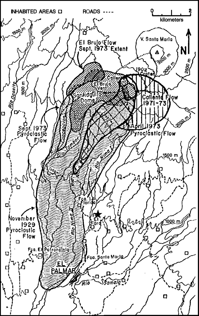 |
Figure 16. Map of Santiaguito and environs showing zones affected by the 1929, 1973, and 1989-90 pyroclastic flows. The zones affected in 1989-90 are marked by vertical lines (devastation by lateral blasts), and diagonal lines (area affected by pyroclastic flows and ash cloud surges). The Santiaguito Observatory is marked by a star. Courtesy of Michael Conway. |
"Periods between major explosions have been characterized by passive fuming of Caliente and by minor phreatomagmatic and possibly phreatic vertical explosions. On the morning of 28 November, from the 'Hotel de Magermann', NW of the dome, we observed a series of 15-20 small explosions; each was accompanied by a gray to white steam and ash column, rising 1.5-3 km above Caliente. Individual explosions were accompanied by a jet-like sound and lasted anywhere from a few seconds to 2-3 minutes. Passive fuming preceded and followed each blast.
"Since July, a viscous block lava flow, fed by a plug dome on Caliente, has advanced down the E side of the dome, and recently entered the headwater extension of the Río Nimá II system (figure 17). The flow is roughly 2 km long, 30-50 m wide, and 15-20 m high; a rough estimate of the average extrusion rate is 7,500 m3/day. Collapse of the lava flow front occurs frequently, and small-volume block-and-ash avalanches are common events. Merapi-type block and ash flows are less common and travel between 2 and 3 km down the Río Nimá II.
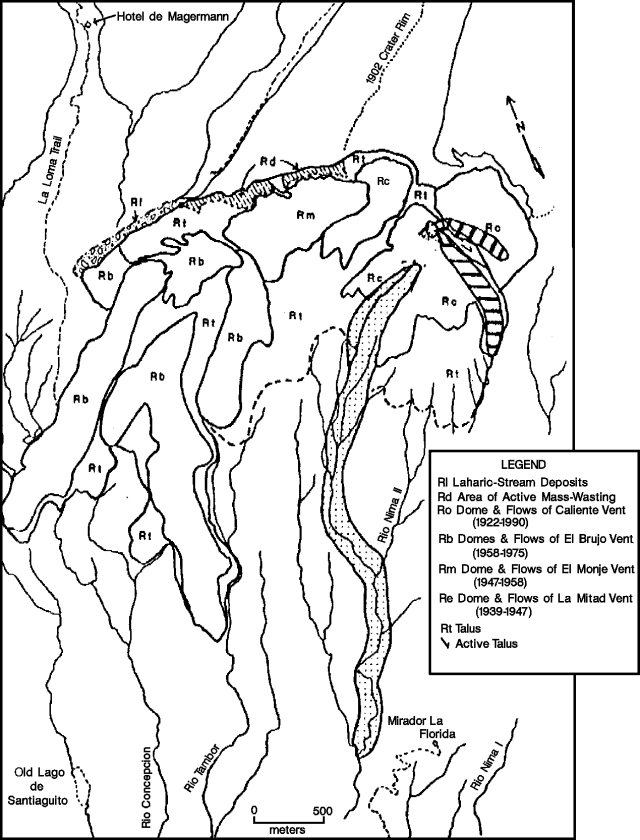 |
Figure 17. Simplified geologic map of Santiaguito Dome, 1922-November 1990. Streams near Santiaguito are approximately located. Unit dates, such as Rc (1922-90), represent periods of discontinuous activity at each vent. Patterned areas represent very recent activity: Rl - area of active laharic and stream deposition, and very high aggradation rates; Rd - area of recently initiated extensive mass wasting possibly indicating inflation of the El Monje vent and potential reactivation; Rc (v pattern) - active block lava flow on Caliente's summit, with very common (hourly) collapse of the broad toe resulting in hot rock avalanches; Rc (dotted pattern) - extent of the 1986-88 block lava flow from Caliente. Lava flows erupted since July 1990 are shown by diagonal and horizontal line patterns; the S-most unit, extending into the Río Nimá II drainage, was active as of 28 November. Courtesy of Michael Conway. |
"Lahars originating at Santiaguito, common during the past rainy season, extended S down the Río Nimá II to its confluence with the Río Samala, and continued for up to 50 km from the dome (figure 18). Diversion of lahars from the Río Samala into the Río Ixpatz occurred as it has in every year since 1983. Hot lahars (temperatures to 45°C were measured 25 km S of the dome) were observed and occurred hours to days after a major pyroclastic eruption. A particularly large lahar on 16 September destroyed the pedestrian bridge at El Palmar, forcing people of the surrounding area to ford the river on foot - a particularly hazardous endeavor during the rainy season. Rapid aggradation from lahars and hyperconcentrated floods continues in the Río Nimá and Río Samala systems.
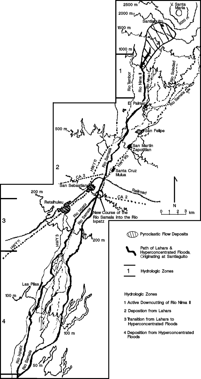 |
Figure 18. Sketch map of rivers and towns S of Santiaguito. Locations of drainages are approximate. Areas affected by pyroclastic flows, lahars, and hyperconcentrated floods are marked. Field studies during the 1990 rainy season indicate four zones with distinct hydraulic characteristics. [Courtesy of O. Matías.] |
"In order to monitor activity better at Santiaguito, INSIVUMEH and Centro de Prevención de Desastres Naturales en América Central (CEPREDENAC) have constructed a permanent observatory at Finca El Faro, 7 km S of the dome (figure 16). The observatory opened in the second week of November and will be manned around-the-clock, by trained observers. Equipment at the observatory includes: a paired seismometer-seismograph, seismographs for two outlying seismometers; deformation and survey equipment; and hand-held radios and radio-telephone equipment. A key function of the observatory is to act as a training post for geoscientists, and at present 25 geoscientists from throughout Central America are receiving training in seismology, deformation, and volcanic hazards at Santiaguito." [The following originally appeared in BGVN 16:02] The building site was donated by the owners of Finca El Faro and construction costs were paid by the government of Sweden through CEPREDENAC. The facility has laboratory space and a small dormitory, and is intended as a base of operations for volcanologists to work with local scientists at Santiaguito (through INSIVUMEH and other agencies).
Geological Summary. Symmetrical, forest-covered Santa María volcano is part of a chain of large stratovolcanoes that rise above the Pacific coastal plain of Guatemala. The sharp-topped, conical profile is cut on the SW flank by a 1.5-km-wide crater. The oval-shaped crater extends from just below the summit to the lower flank, and was formed during a catastrophic eruption in 1902. The renowned Plinian eruption of 1902 that devastated much of SW Guatemala followed a long repose period after construction of the large basaltic andesite stratovolcano. The massive dacitic Santiaguito lava-dome complex has been growing at the base of the 1902 crater since 1922. Compound dome growth at Santiaguito has occurred episodically from four vents, with activity progressing E towards the most recent, Caliente. Dome growth has been accompanied by almost continuous minor explosions, with periodic lava extrusion, larger explosions, pyroclastic flows, and lahars.
Information Contacts: Otoniel Matías, INSIVUMEH; Michael Conway, Michigan Tech.