Report on Galeras (Colombia) — September 1991

Bulletin of the Global Volcanism Network, vol. 16, no. 9 (September 1991)
Managing Editor: Lindsay McClelland.
Galeras (Colombia) Lava extrusion follows increased tephra emission, seismicity, and deformation
Please cite this report as:
Global Volcanism Program, 1991. Report on Galeras (Colombia) (McClelland, L., ed.). Bulletin of the Global Volcanism Network, 16:9. Smithsonian Institution. https://doi.org/10.5479/si.GVP.BGVN199109-351080
Galeras
Colombia
1.22°N, 77.37°W; summit elev. 4276 m
All times are local (unless otherwise noted)
Increased tephra emission, seismicity, and deformation culminated in the extrusion of a summit-crater lava dome in mid-October.
Activity continued to increase in September, with the highest number of events, the greatest released energy, and largest reduced displacement of long-period earthquakes since the start of monitoring in February 1989 (figure 44), surpassing the previous highs recorded in August. Tremor episodes and long-period events were associated with explosions, continuous ash emission, and occasional block ejections to 200 m from the vent. The SO2 flux was relatively low, <=650 t/d, except on 20-25 September when values of 960-1,045 t/d were recorded. Low SO2 fluxes were also recorded during August (<=370 t/d). The electronic tiltmeter [at Crater Station] became saturated, after recording 231 µrad of inflation during the first 2 weeks of August. Two km E of the crater, the Peladitos electronic tiltmeter showed 46.2 µrad of inflation at 242° azimuth (figure 45), compared to 3.7 µrad at 183° azimuth during the first 2 weeks of August. A change in the inclination of the radial component was recorded 9-13 September.
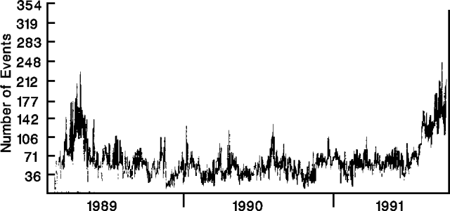 |
Figure 44. Daily number of earthquakes at Galeras, February 1989-September 1991. Courtesy of INGEOMINAS. |
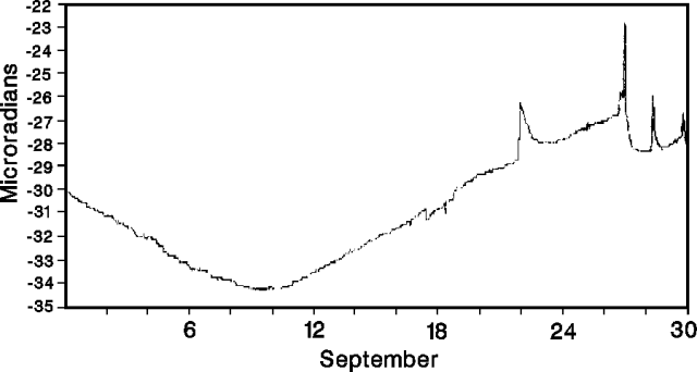 |
Figure 45. Radial component of deformation measured 2 km E of the crater ("Peladitos" electronic tiltmeter) at Galeras, September 1991. Courtesy of INGEOMINAS. |
Fieldwork in mid-October revealed a lava dome in the main crater [but see 16:10]. [The dome was 30 m thick and 80-100 m in diameter by the 17th]. Incandescence was visible in cracks on the dome's surface, but bad weather prevented detailed observation.
Geological Summary. Galeras, a stratovolcano with a large breached caldera located immediately west of the city of Pasto, is one of Colombia's most frequently active volcanoes. The dominantly andesitic complex has been active for more than 1 million years, and two major caldera collapse eruptions took place during the late Pleistocene. Long-term extensive hydrothermal alteration has contributed to large-scale edifice collapse on at least three occasions, producing debris avalanches that swept to the west and left a large open caldera inside which the modern cone has been constructed. Major explosive eruptions since the mid-Holocene have produced widespread tephra deposits and pyroclastic flows that swept all but the southern flanks. A central cone slightly lower than the caldera rim has been the site of numerous small-to-moderate eruptions since the time of the Spanish conquistadors.
Information Contacts: INGEOMINAS-OVP; S. Williams and M. Calvache, Arizona State Univ.