Report on Akutan (United States) — November 1991
Bulletin of the Global Volcanism Network, vol. 16, no. 11 (November 1991)
Managing Editor: Lindsay McClelland.
Akutan (United States) Summit tephra emission
Please cite this report as:
Global Volcanism Program, 1991. Report on Akutan (United States) (McClelland, L., ed.). Bulletin of the Global Volcanism Network, 16:11. Smithsonian Institution. https://doi.org/10.5479/si.GVP.BGVN199111-311320
Akutan
United States
54.134°N, 165.986°W; summit elev. 1303 m
All times are local (unless otherwise noted)
Summit tephra emissions resumed in mid-September . . . . Observer's initials, in brackets, follow their information in the chronology below.
15 September: Voluminous black emissions rose ~300 m from the summit cone between 0800 and 0900. White steam with some black material was briefly emitted shortly after 0900 [F/R].
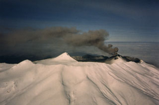
27 September: Dark gray, billowing plume to roughly 2,500 m altitude seen from an aircraft during the morning [DT]. Clouds obscured the volcano during the afternoon.
29 September: Small tephra plume to <2,500 m altitude seen from an aircraft at 1315 [JR]. Six brief tephra emissions, the first three at 1517, 1520, and 1535, fed black to light-brown plumes that rose to an estimated 3,000 m within a minute [MO]. Black plume emission was observed for 3 minutes at about 1800 [T]. Another plume rose ~4,500 m sometime between 2000 and 2100 [MO]. Snow on the volcano remained white that evening, but was ash-covered by the next afternoon, when some fine ash was evident on flat surfaces 12.5 km E of the volcano (in Akutan village) [MO & BJ].
11 October: Plumes rose briefly to about 2,400 m and 2,100 m altitudes at 1030 and 1100, respectively [DT].
13 October: Trace of ash fell on Akutan village. Ash was seen falling through clouds on the W end of Akutan Bay [MO].
14 October: Emission of gas and black ash was nearly continuous, to roughly 1,000 m above the summit. Larger explosive episodes occurred approximately hourly; the first was observed at 0935 (shortly after dawn), rising 1,500-1,800 m above the volcano [MO & NS]. Six dark plumes rose at least 500 m above the volcano between 1530 and 1730 [BJ]. One, at 1721, reached 1,500 m above the summit [JW].
18 October: Continuous steaming, with emission of at least 6 dark short-lived plumes to 450-600 m height [MO].
19 October: Ash blackened snow down to the snow-line (at about 300 m altitude) [BJ].
30 October: White gas plume about 600 m high emitted between 0800 and 1000. No gas emission was evident between 1300 and 1500, but ash had fallen N of the crater rim since the last snow, 2 days earlier [ML].
Observers (initials in brackets): F/R - unidentified fisherman aboard the Richards (Seattle); DT and JR - Darren Talmadge and Jodeann Ryan, MarkAir; MO, BJ, and ML - Mark Owen, Bret Joines, and Michael Lockhart, Trident Seafood; T - crew of the Tarpon (Petropavlovsk-Kamchatsky); NS - Nick Sias (Peninsula Airways); JW - Jack Wood, OESI Corp.
Geological Summary. Akutan contains a 2-km-wide caldera with a large cinder cone in the NE part of the caldera that has been the source of frequent explosive eruptions and occasional lava effusion that covers the caldera floor. An older, largely buried caldera was formed during the late Pleistocene or early Holocene. Two volcanic centers are located on the NW flank. Lava Peak is of Pleistocene age, and a cinder cone lower on the flank produced a lava flow in 1852 that extended the shoreline of the island and forms Lava Point. The 60-365 m deep younger caldera was formed during a major explosive eruption about 1,600 years ago and contains at least three lakes. A lava flow in 1978 traveled through a narrow breach in the north caldera rim almost to the coast. Fumaroles occur at the base of the caldera cinder cone, and hot springs are located NE of the caldera at the head of Hot Springs Bay valley and along the shores of Hot Springs Bay.
Information Contacts: J. Reeder, ADGGS.