

Steaming, seismically active
We report Akutan non-eruptive seismic activity after our mid-1996 report (BGVN 21:06) through December 2010. AVO (Alaska Volcano Observatory) reporting emphasized seismicity in 2000, 2007, 2008, 2009, and 2010, including seismicity during 2007 triggered by an M 8.2 earthquake in the Kurile islands.
Background. Akutan Island is home to indigenous people located in several coastal villages, and the base of a large fish processing facility. The island resides in the Aleutian arc, a string of islands projecting ~2,000 km into the Bering Sea from the Alaskan Peninsula (figure 2).
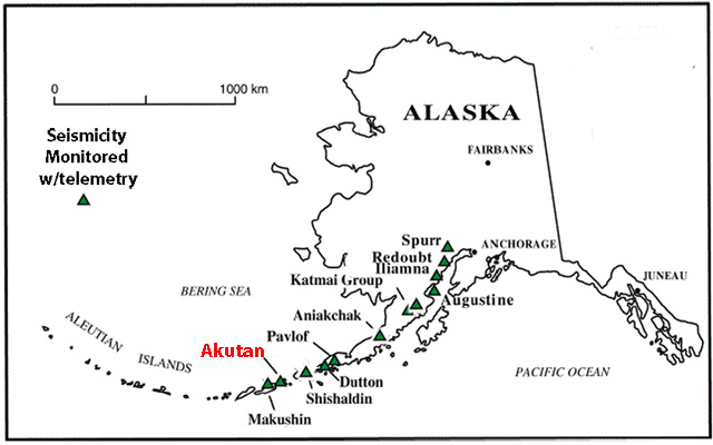 |
Figure 2. Akutan, an island ~32 km by ~20 km, lies on the E Aleutian arc in the Bering Sea near the coast of Alaska. Courtesy of Neal and McGimsey (1996), revised by GVP. |
Akutan Island (figure 3) has a vegetated coast line dotted with spectacular bridges and caves created by the erosion of numerous lava tubes. Waythomas and others (1998) presented a map showing that much of the coastline is susceptible to rockfall avalanches and points out that these may trigger local tsunamis. The authors also analyzed the likely path of lava flows.
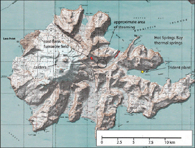 |
Figure 3. Akutan Island and its volcanic features, including fumaroles, hot springs, and a new steaming area. A cindercone resides in the NE quadrant of the generally circular caldera. The fumarole field, shown in red, is down slope on the E flank of the summit. The Trident seafood plant, shown as a yellow star, lays along the E coast. Courtesy of AVO, revised by GVP. |
A 2 km diameter caldera atop the 1,303 m high volcano is breached to the NW, and elsewhere encircled by crater walls 60 to 365 m high. The caldera contains a ~200 m high cinder cone, and a small lake. Fumeroles lay along the summit flank toward the E (Miller and others, 1998). The cinder cone has been the site of all historical eruptive activity (Richter and others, 1998; Waythomas and others, 1998).
The village of Akatan ( figure 4), ~ 13 km E of the volcano, hosts the Trident seafood plant, the largest such plant in North America, employing up to 900 seasonal workers (McGimsey, 2011). Akutan villagers and seafood plant employees fled the island during the 1996 seismic events (Li and others, 2000). The cited references provide many details omitted here.
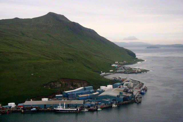 |
Figure 4. Akutan coastal image with seafood plant in foreground adjacent to Akutan village. Image courtesy of AVO, created by Helena Buurman. |
According to Diefenbach and others (2009), Akutan has been the most active of the volcanoes monitored by AVO, having over 20 eruptions since 1790; more than any other Alaskan volcano.
A 2009 report by AVO noted that 11 eruptions occurred at Akutan during 1980-1992, many lasting several months (table 5). The most recent eruption started in December 2009 but the eruption's end was not clearly constrained (table 5). A seismic swarm took place in 1996, an episode without a corresponding eruption.
Table 5. Akutan eruptions tabulated from January 1980 to 2009. Courtesy of Diefenbach and others (2009).
| Start Date | End Date | VEI |
| 08 Jul 1980 | 08 Jul 1980 | 2 |
| 07 Oct 1982 | May 1983 | 2 |
| 03 Feb 1986 | 14 Jun 1986 | 2 |
| 31 Jan 1987 | 24 Jun 1987 | 2 |
| 26 Mar 1988 | 20 Jul 1988 | 2 |
| 27 Feb 1989 | 31 Mar 1989 | 2 |
| 22 Jan 1990 | 22 Jan 1990 | 2 |
| 06 Sep 1990 | 01 Oct 1990 | 2 |
| 15 Sep 1991 | 28 Nov 1991 | 2 |
| 08 Mar 1992 | 31 May 1992 | 2 |
| 18 Dec 1992 | -- | 1 |
From 1980 to 2009, Alaskan eruptions made up to 77% of the total reported in the United States (Diefenbach and others, 2009). Note that, even though during 1980-2009 Akutan erupted more times than other US volcanoes, this distinction is only one of many that can be used for comparisons. For example, in the course of that interval and the 11 recorded eruptions at Akutan, it clearly emitted less material and the eruptive intervals spanned much less time than eruptions at either Kīlauea or Mt. St. Helens.
1996 seismicity. In March 1996, two strong earthquake swarms struck the island, causing minor damage and prompting some residents and dozens of plant employees to leave the island. The seismicity, reported in BGVN 21:06, was probably the result of a magmatic intrusion (Lu and others, 2000). They stated the following:
"In March 1996 an intense swarm of volcano-tectonic earthquakes (~3,000 felt by local residents, M max = 5.1, cumulative moment of 2.7 × 10¹⁸ N m) beneath Akutan Island in the Aleutian volcanic arc, Alaska, produced extensive ground cracks but no eruption of Akutan volcano. Synthetic aperture radar interferograms that span the time of the swarm reveal complex island-wide deformation: the western part of the island including Akutan volcano moved upward, while the eastern part moved downward. The axis of the deformation approximately aligns with new ground cracks on the western part of the island and with Holocene normal faults that were reactivated during the swarm on the eastern part of the island. The axis is also roughly parallel to the direction of greatest compressional stress in the region. No ground movements greater than 2.83 cm were observed outside the volcano's summit caldera for periods of 4 years before or 2 years after the swarm. We modeled the deformation primarily as the emplacement of a shallow, E-W trending, north dipping dike plus inflation of a deep, Mogi-type [spherical] magma body beneath the volcano. The pattern of subsidence on the eastern part of the island is poorly constrained. It might have been produced by extensional tectonic strain that both reactivated preexisting faults on the eastern part of the island and facilitated magma movement beneath the western part. Alternatively, magma intrusion beneath the volcano might have been the cause of extension and subsidence in the eastern part of the island."
The 11 March 1996 swarm involved more than 80 earthquakes of M 3.0 or greater with the largest measuring M 5.2. The 13 March swarm involved more than 120 events of M 3.0 or greater with the largest measuring M 5.3 (Waythomas and others, 1998).
As a result, new ground cracks developed ( figure 5) and Waythomas and others (1998) described them as follows: "Numerous fresh, linear ground cracks were discovered in three areas on Akutan Island during field studies in the summer of 1996. Ground breaks and cracks likely formed during the strong seismic swarms in March. The ground cracks extend discontinuously from the NE side of the island near Lava Point to the island's SE side [figure 5].
"The most extensive ground cracks are between Lava Point and the volcano summit [ figure 6]. In this area, the cracks are confined to a zone 300 to 500 m wide and 3 km long. Vertical displacement of the ground surface along individual cracks is 30 to 80 cm. The ground cracks probably formed as magma moved toward the surface between the two most recently active vents on the volcano. Ground cracks on the SE side of the island occur on known faults, indicating that they probably formed in response to motion along these preexisting structures. No ground cracks were found at the head of Akutan Harbor even though this was an area where numerous earthquakes occurred from March through July, 1996."
|
Figure 5. Location of ground cracks and seismometers on Akutan, as published in 1998. Three sets of ground cracks, shown as black lines, presumably formed during the March 1996 earthquake swarm. The most extensive breaks occurred on the NW flank of the volcano near Lava Point with the other two shorter sets to the SE in line with the first. On the map, the green triangles locate seven monitoring stations, one at the summit, and others spread throughout the island as well as one at the village. Courtesy of AVO, Waythomas and others (1998), annotated by GVP. |
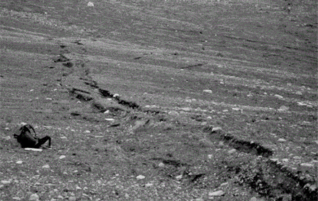 |
Figure 6. Ground breaks like this were found at Akutan in a zone about 300-500 m wide and ~ 3,000 m long on the NW flank of the volcano. Surface deposits offset by the cracks consist of course tephra and colluvium. The backpack in the lower left delineates scale (distant figures removed for clarity). Courtesy of AVO, Waythomas and others (1998). |
A permanent seismic network was installed during the summer of 1996 which currently consists of seven short-period stations and five broadband stations (figure 5).
Akutan seismicity, 2000 to 2010. According to AVO annual reports covering the interval 1997-2011, noteworthy seismicity occurred during the years 2000, 2007, 2008, 2009, and 2010.
On 19 January 2000, five earthquakes occurred in less than 30 minutes with epicenters 10-11 km E of the summit at hypocentral depths of ~5-6 km. This was the same region as the March 1996 volcanic swarm.
Akutan was one of several Alaska volcanoes with behavioral anomalies triggered by the M 8.2 earthquake generated in the Kurile Islands on 12 January 2007 at 0423 UTC (McGimsey, 2011). Seismologists located four of the seven largest triggered M 0.0-0.5 earthquakes at Akutan and found their depths in the range from +0.86 to -2.17 km (figure 7). The locations fell along the trend of intense seismicity and ground breakage that occurred in March 1996 at Akutan (Neal and others, 1997; Waythomas and others, 1998; Lu and others, 2005). The AVO Akutan seismic network recorded the triggered seismicity.
|
Figure 7. Epicenters at Akutan triggered by the 13 January 2007, M 8.2 Kurile Islands earthquake (the event occurred at 0423 UTC, 12 January 2007). The four largest events (red dots) lie along the same trend (blue line) as that of intense seismicity with accompanied ground breakage that occurred during dike intrusion in March 1996 (Waythomas and others, 1998). Open triangles mark locations of seismic stations. Plot of earthquake locations by John Power. Courtesy of AVO, McGimsey and others (2011). |
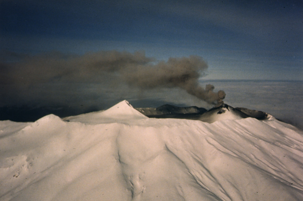
In early October 2007, AVO remote sensors detected signs of renewed inflation of the W flank during the previous month using GPS time series. This inflation was in the same area that inflated during the 1996 seismic crisis. A few days later, on 8 October 2007, the manager of the Trident seafood processing plant called to alert AVO of strong steaming near Hot Springs Bay (figure 8) at a spot significantly up slope from established hot springs in the valley. This plume location was considered "new" by local observers. The established lower-valley thermal springs rarely emit a concentrated, vertically rising steam plume and most earlier reports of steaming arose from the prominent fumarole field located at the 460 m elevation of the E flank at the headwaters of Hot Springs Bay valley. This is also the area of maximum deflation following the 1996 seismic swarms. No unusual seismic activity was noted for the period of W-flank inflation or the location of this steaming episode (McGimsey and others, 2011).
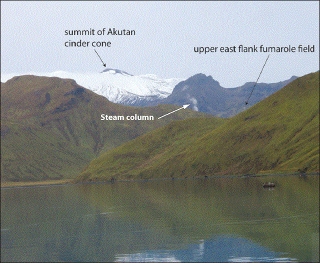 |
Figure 8. Midway up Akutan's Hot Springs Bay valley on the E flank of Akutan from a point well upslope of the previously active hot springs area, a steam column rises from a new site. AVO photo taken 8 October 2007 by David Abbasian. |
In 2008, over 100 seismic events were recorded. During the next two years, Akutan seismic events decreased to about half that number. During 2010 low frequency earthquakes doubled compared to 2009 (Table 6).
Table 6. Akutan seismic activity for 2008-2010 compiled from AVO/USGS annual reports. Total earthquakes (in the second column) summed those in the Volcano-tectonic and Low frequency columns. '--' indicates data not reported. Courtesy of AVO.
| Year | Total earthquakes | Volcano-tectonic | Low-frequency |
| 2008 | 105 | -- | -- |
| 2009 | 45 | 41 | 4 |
| 2010 | 42 | 34 | 8 |
According to AVO, Akutan seismic events during the years 2009 and 2010 were temporally spread roughly throughout the months except for a tight cluster of M 2 earthquakes reported at depths of between ~5 km to ~10 km during the first weeks of January 2010. The majority of earthquakes in 2010 were located within ~5 km of the crater along a N-trending line spanning 10 km. In 2009 the spread was longer, over 20 km.
References. Diefenbach, A.K., Guffanti, M., and Ewert, J.W., 2009, Chronology and references of volcanic eruptions and selected unrest in the United States, 1980-2008: U.S. Geological Survey Open-File Report 2009-1118, 85 p. [http://pubs.usgs.gov/of/2009/1118/].
Dixon, J.P., Stihler, S.D., Power, J.A., and Searcy, C.K., 2010, Catalog of Earthquake Hypocenters at Alaskan Volcanoes: January 1 through December 31, 2009: U.S. Geological Survey Data Series 531.
Dixon, J.P., Stihler, S.D., Power, J.A., and Searcy, C.K., 2011, Catalog of earthquake hypocenters at Alaskan Volcanoes: January 1 through December 31, 2010: U.S. Geological Survey Data Series 645.
Kent, T., 2011, Hydrothermal Alteration of Open Fractures in Prospective Geothermal Drill Cores, Akutan Island, Alaska, Fall Meeting of the American Geophysical Union, 2011, Abstract ##V13D-2637.
Lu, Z., Wicks Jr., C., Power, J.A., and Dzurisin, D., 2000, Ground deformation associated with the March 1996 earthquake swarm at Akutan volcano, Alaska, revealed by satellite radar interferometry, J. Geophys. Res., 105(B9), 21,483-21,495 (DOI:10.1029/2000JB900200).
Miller, T.P., McGimsey, R.G., Richter, D.H., Riehle, J.R., Nye, C.J., Yount, M.E., and Dumoulin, J.A., 1998, Catalog of the historically active volcanoes of Alaska: U.S. Geological Survey Open-File Report 98-582, 104 p. (Also available at http://www.avo.alaska.edu/downloads/catalog.php.)
McGimsey, R.G., Neal, C.A., Dixon, J.P., Malik, Nataliya, and Chibisova, M., 2011, 2007 Volcanic activity in Alaska, Kamchatka, and the Kurile Islands: Summary of events and response of the Alaska Volcano Observatory: U.S. Geological Survey Scientific Investigations Report 2010-5242, 110 p.
Neal, C.A. and McGimsey, R.G., 1997, 1996 Volcanic Activity In Alaska And Kamchatka: Summary Of Events And Response Of The Alaska Volcano Observatory: U.S. Geological Survey Open-File Report 97-433.
Richter, D.H., Waythomas, C.F., McGimsey, R.G., and Stelling, P.L., 1998, Geologic map of Akutan Island, Alaska: U.S. Geological Survey Open-File Report 98-135, 22 p., 1 plate.
Waythomas, C.F., Power, J.A., Richter, D.H., and McGimsey, R.G., 1998, Preliminary volcano-hazard assessment for Akutan Volcano east-central Aleutian Islands, Alaska: U.S. Geological Survey Open-File Report 98-0360, 36 p., 1 plate.
Information Contacts: Alaska Volcano Observatory (AVO), a cooperative program of a) U.S. Geological Survey, 4200 University Drive, Anchorage, AK 99508-4667, USA, b) Geophysical Institute, University of Alaska, PO Box 757320, Fairbanks, AK 99775-7320, USA, and c) Alaska Division of Geological & Geophysical Surveys.
The Global Volcanism Program has no Weekly Reports available for Akutan.
Reports are organized chronologically and indexed below by Month/Year (Publication Volume:Number), and include a one-line summary. Click on the index link or scroll down to read the reports.
Ash and steam has been erupting for several months according to pilots
Card 1643 (22 May 1973) Ash and steam has been erupting for several months according to pilots
"Reeve-Aleutian Airways pilots report that Akutan volcano has been erupting ash and steam for several months. The ERTS satellite image 1056-21331 of 17 September 1972 show the mountain to be essentially snow-free, as opposed to adjacent areas of similar altitude."
Information Contacts: D.B. Stone, Geophysical Institute, University of Alaska.
Ship crew observes ash and tephra emission and lava flow
Card 1812 (08 March 1974) Ship crew observes ash and tephra emission and lava flow
At 0900 GMT 11 February 1974, Akutan was observed to be in a state of eruption by the crew of the SS Summit. Reportedly, volcanic ash and debris were spewing several hundreds of feet into the air, and molten lava was flowing down the side of the 2,081-foot peak toward the Lava Bight for several hundred yards. The eruption flared up and died down at intermittent intervals. The Summit passes the Akutan Island area frequently, but has not observed this phenomenon at this position before.
Information Contacts: H.G. Gunderson, Third Officer, SS Summit, Kodiak, AK; David Carver, National Earthquake Information Service, USGS.
Ash eruptions observed in early May
Eruptive activity, reported from this volcano in 1973 and 1974, resumed on 5 May and was continuing four days later. Personnel aboard the USCG Cutter Ironwood observed eruptions of light brown ash clouds about every 15 minutes between 1700 and 2000 on 5 May. The ash blew to the N but only a thin layer was noted on the snow-covered N side of the island. The ash eruptions were separated by periods of white steam emission. Richard Maloney, an airline pilot, saw incandescent ash during an overflight at 1730 on 6 May and more ash eruptions on 7 May. The Ironwood returned to the island at 1900 on 9 May and activity similar to that of 5 May was observed. Villagers on Akutan report sporadic activity since last autumn.
Information Contacts: T. Miller, USGS, Anchorage.
Strombolian activity and possible lava flow
Akutan began to erupt in late September 1978. Airline pilots reported incandescent fragments, some "as big as a car," rising about 100 m above the crater. The USCG Cutter Morgenthau passed N of Akutan during the evening of 6 October. Crew members observed incandescent tephra ejection from the summit and glow reflecting upward onto an eruption column. A deep red glow about 1 km long, which appeared to be a lava flow, moved down the flanks.
Information Contacts: M. Compton, USCGC Morgenthau; D. Hoadley, Reeve Aleutian Airways; J. Kienle, Univ. of Alaska.
Steam and ash emission; recently-extruded lava flow
Akutan was observed by J. Davies on 3 July and by J. Hauptmann and G. Gunther on 8 July. The volcano was not active on the 3rd, but Davies saw a fresh-looking lava flow that had moved through a breach in the NNW caldera wall. On 8 July, the volcano was emitting steam and dark brownish-grey ash.
Information Contacts: J. Davies, J. Hauptmann, G. Gunther, and S. McNutt, LDGO.
Small steam and ash plume
A plume that was mostly steam but contained some ash was ejected on 28 April 1986. Airplane pilots reported that the plume rose to ~2.5 km altitude. Dark ash fell on the snow-covered volcano. Island residents smelled a strong sulfur odor during the following days, but weather clouds obscured the volcano.
Information Contacts: T. Miller, USGS Anchorage.
Steam and ash emission
Increased steam emission . . . was reported on 31 December and plumes rising to estimated altitudes of as much as 5.2 km . . . have been occasionally observed since then. Ash was first visible in a plume on 18 March and numerous ash columns were seen 1-7 June. No ashfalls have been reported this year in Akutan village, 12 km E of the volcano, but fresh-looking ash was observed 5 June on the upper NE flank.
John Reeder provided the following pilot and ground observations. On 31 December at about 1100, James and Abi Dickson observed an anomalously large white apparently ash-free steam plume over Akutan. From Dutch Harbor airport (46 km from the volcano), the plume height was estimated at 550 m. The plume remained visible in clear, fairly calm weather until sunset, at around 1600. On 3 February at 1000, James Dickson noted a large vertical steam plume emerging from the vicinity of the volcano and by 1400, the plume height had roughly doubled. From Unalaska (47 km from Akutan), Abi Dickson estimated the plume's maximum altitude at 5.2 km. Maximum plume width was about 900 m.
On 18 March, Aleutian Air pilot T. Madsen observed weak but steady ejection of steam and black ash from Akutan's cinder cone. During his next overflight, on 22 March, ash ejection had stopped. The crater seemed to have enlarged slightly and appeared to be more centrally located than its previous position on the NW part of the summit. Minor steam venting was occurring from the upper and lower N and S flanks, but no steam was emerging from the central crater.
On 28 April at about 1530, Reeve Aleutian captain Lee Goch observed a large billowing white plume over Akutan, reaching ~2 km altitude and extending ~8 km SW. By 1539, the end of the plume was 16 km SW of the volcano. Nothing unusual had been evident . . . when he flew past 1.5 hours earlier. Immediately after hearing Goch's radio report, AirPac pilot Nickol Sias flew to within 300 m of the active cinder cone. It was vigorously emitting a white steam column. There was no ash in the plume and no new ash deposits were evident on the cinder cone, the caldera floor, or the volcano's flanks. Most of the cinder cone was covered with fresh snow, but fairly large circular melt areas on its N and S sides extended nearly to its base. Minor steaming was occurring from both melt areas. Two days later at 1615, Goch observed a steam plume that rose only ~150 m before drifting ~50 km E. On 1 May, fisherman Halvor Ostebovik noted a long brownish horizontal haze from ~16 km N of Akutan Island.
While flying at 430 m altitude just over the NW rim of the caldera on 6 May at about 0920, T. Madsen encountered sulfur-rich volcanic gases that severely irritated his eyes. A billowing steam cloud emerged steadily from the black cinder cone. On 6 and 7 May at about 1300, MarkAir captain Jerry Chisum saw steam plumes (with no obvious ash) rising at about a 45° angle to 1,100 m height. The plume drifted WNW on the 6th and S on the 7th. Madsen saw a very light gray plume that moved ~30 km S . . . about an hour before Chisum's flight on the 7th. Activity was similar just before noon the next day. At 1530, Goch reported only a 30-m plume from the volcano, but noted two craters on the cinder cone, one N and one S of its summit. On 10 May, Madsen saw very little steam emerging from the snow-free cone.
The USGS reports that personnel from the Trident Fisheries cannery in Akutan village observed numerous eruptive episodes in a 3.5-hour period on 1 June: 0715, grayish black cloud to ~3 km altitude; 0800, black cloud to 3.5 km; 0830, steam-rich cloud to 2 km; 0912, grayish cloud to 2.5 km; 0940, light-colored steam-rich cloud to 2.5 km; 1020, dense black cloud to 3.5 km; 1038, black cloud passed through weather cloud deck at 3.5 km; 1050, dense black cloud entered weather clouds at 3.5 km, the largest episode of the sequence. Weather clouds then obscured the volcano. The USGS noted that the observed activity is above background for Akutan, but not unusual.
John Reeder reported that residents of Akutan village heard booming noises during the 1 June activity. At 0950, Steve Besroches and Jamie Kase of Akutan village saw an ash cloud rise to 2.5 km altitude in somewhat less than 2 minutes. MarkAir captain Clint Schoenleber passed the volcano at l200 and 1300 but detected no ash. Besroches and Kase saw ash plumes at about 1400 and 1600. Both plumes appeared to reach ~4 km altitude and drifted slowly NE. The second plume was visible for about an hour.
Madsen noted fresh-looking ash on the upper NE flank on 5 June. The next day at about 1400, Reeve Aleutian captain Edward Livingston saw a dark vertical plume emerge from a weather cloud layer at 2.7 km altitude and rise to 4 km within ~15 seconds. On his return flight 1 hour later no ash was visible. The following day at about 1500 the volcano was shrouded in clouds, but a gray ash layer at 2.7 km altitude appeared to have drifted about 6 km ESE. That evening at about 1830, Madsen detected an 8-km-wide zone of ash that extended ~65 km E from the volcano at 1.5 km altitude.
Information Contacts: J. Reeder, ADGGS; T. Miller and M. Yount, USGS Anchorage.
Ash plumes from caldera cinder cones
On 30 June at 1840, Reeve Aleutian Airways captain Lee Goch saw gray-black ash emission from the active cinder cone in the caldera. Weather clouds just above the summit were discolored by the ash. Fresh-looking ash had been deposited on the upper N, NW, and W flanks. No additional reports of activity have been received since the end of June.
Information Contacts: J. Reeder, ADGGS.
More June ash observations
John Reeder has received two additional June observations . . . . MarkAir captain Clint Schoenleber observed unusual amounts of black ash on the S flank on 14 June at 1315. The ash had not been present two days earlier. Only steam was emerging from the cinder cone in the caldera. Snow had fallen near the summit since the ashfall. At about 2000 the same day, Julie Hathaway of Dutch Harbor saw a dark cloud that probably emerged from Akutan and was drifting south. The cloud remained visible for ~1/2 hour. She saw a similar cloud between 2100 and 2130 and two more between then and 2400.
Information Contacts: J. Reeder, ADGGS.
Steam and ash emission
From 5 January to 11 February intermittent steam and ash plumes were reported from a cinder cone (table 1). Minor ashfall occurred at Akutan village on 1 February.
Table 1. Summary of reports of activity at Akutan, 5 January-3 March 1987, collected by J. Reeder. Observers (initials in brackets): Tom Madsen, Aleutian Air; Harold Wilson, Guy Morgan, Theresa Dubber (passenger), Nick Sias, Peninsula Airways; Lee Goch, Don Munson, Janice Reeve Ogle, Reeve Aleutian Airways; David McGlashan, Akutan village; Teddy Jepsen, Trident Sea Foods Corp., Akutan; Jerry Chisum and Ray Wells, Markair; Captain Mets and the 17th Tactical Airlift Squadron; Julie Hathaway and Abi Dickson, Unalaska; Stan Carrick and Ed Collazzi, State of Alaska Hydrologists.
| Date | Time | Activity [with observers] |
| 05 Jan 1987 | 1150 | Above-average steaming and sulfuric odors [TM]. |
| 05 Jan 1987 | 1600 | Steam plume rose 180 m above the cinder cone; melted snow left black areas on the cone [HW]. |
| 31 Jan 1987 | 1100 | Steam and ash plume drifted NW [TM]. |
| 31 Jan 1987 | 1500 | Minor steam emission [LG, DM, JO]. |
| 02 Feb 1987 | 1030 | Vertical ash plume grew to 900 m; upper N flank covered with fresh ash [TJ]. |
| 02 Feb 1987 | 1445 | No ash or steam emissions [LG, JF]. |
| 03 Feb 1987 | 1435 | 530-m-high steam-and-ash plume; most ash emitted from an upper NW-flank vent on the cinder cone; steam plume on the upper S flank [TM]. |
| 03 Feb 1987 | 1510 | 180-m-high plume drifting 9 km NE; ash covered the caldera [GM, TD]. |
| 07 Feb 1987 | 1220 | Dark-brown ash plume extended 5.5 km NE; plume was gone 1 hour later [JC]. |
| 10 Feb 1987 | 1950 | Plume reached 4,900 m altitude (summit altitude is 1,300 m) and drifted 8 km N [CM]. |
| 11 Feb 1987 | a.m. | Gray ash plume rose continuously; drifted SW; fresh black ash visible on upper N flank [TJ]. |
| 11 Feb 1987 | 1015 | Plume reached 300 m above the summit; drifted 65-75 km WSW [TM]. |
| 11 Feb 1987 | 1247 | Dark brownish-gray plume rose to 2,100 m altitude, drifted W [JC]. |
Information Contacts: J. Reeder, ADGGS.
Continuous minor ash emission
Since 11 February, airplane pilots have reported some steam and ash emission every day (table 1). The highest ash column, on 1 March, was followed by increased activity the next day that ejected ash onto the N flank and deposited fine ash on Akutan village 14 km E of the active cinder cone.
[The following was originally mis-reported as being from Makushin.] On 2 March between 1700 and 1940, a dark eruption plume rose about 900 m above the volcano and drifted SW. After the eruption a 60-m-high steam plume remained.
Information Contacts: J. Reeder, ADGGS.
Summit incandescence; ash and steam emission
On about 22 June (± 1 day), a bright red glow from the summit was seen by a fisherman a considerable distance from the volcano in the Bering Sea. On 24 June a pilot reported that the large cinder cone within the summit caldera was sending ash SW at 1,300 m altitude. Two days later pilot H. Wilson (Peninsula Airways) observed a 300-m-high steam plume from the cinder cone and fresh-looking gray-black ash that extended below the snow line on the W flank. No significant eruptive activity was occurring during several sightings from March to early June.
Information Contacts: J. Reeder, ADGGS.
Small ash eruptions
Small ash eruptions from the summit cinder cone were observed in March and April (table 2)....
Table 2. Reports of activity at Akutan, 26 March-late April 1988, compiled by John Reeder from the following observers (initials in brackets): David McGlashan (Akutan Corp.); Tom Madsen (Aleutian Air Ltd.); Grady Thomas and Nick Sias (Peninsula Airways); Anna Jones (Trident Sea Foods).
| Date | Time | Activity [with observers] |
| 26 Mar 1988 | p.m. | Stinging eyes, strong sulfur smell, minor ashfall noted on snow at Akutan village, 12.5 km E of the volcano [DM]. |
| 01 Apr 1988 | -- | Gray ash deposits visible near the summit when weather cleared [DM]. |
| 10 Apr 1988 | 1305 | Black ash rose about 450-600 m above the summit and drifted NW [TM]. |
| 14 Apr 1988 | 1003 | Steam and ash rose through clouds to 2,960 m altitude (summit elevation, 1,303 m); new ash deposit, 1 km wide later that day, extended 9 km SE to the coast [GT, NS]. |
| 14 Apr 1988 | 1000-1500 | Three to four eruptions observed; black to gray ash rose 100 m and drifted W; ash deposits visible on mountains W and SW of Akutan village [AJ, DM]. |
| 17 Apr 1988 | 0930 | 1,200-m black ash cloud ejected, developed a mushroom shape, and blew towards Akutan village, where about 1 mm fell; ashfall looked thicker to the S [AJ]. |
| 19 Apr 1988 | 1254 | Ash emission seen but visibility poor; strong sulfur smell [TM]. |
| 20 Apr 1988 | a.m. | Narrow but mushrooming black ash plume rose to 600 m height in 2 minutes at 0820; similar eruption to 900 m height at 0900; three more dark gray plumes ejected, to no more than 1,200 m, at 0920, 0930, and 1000; all drifted NE [AJ, DM]. |
| 21 Apr 1988 | 0749 | Narrow mushrooming plume rose 1,500 m and drifted NE [AJ]. |
| late April 1988 | -- | Narrow dark ash deposit extended N of the volcano to the coast [NS]. |
Information Contacts: J. Reeder, ADGGS.
Small tephra eruptions resume
During a 5 May overflight, Marsha Brown (FAA, Cold Bay) noted fairly extensive, fresh-looking, black ash deposits on Akutan's flanks. No additional activity was reported until the onset of several days of small tephra eruptions on 31 May, summarized in table 3. Peninsula Airways pilot Nick Sias, who passes over Akutan regularly, notes that he has not seen any incandescent ejecta since the activity began.
Table 3. Reports of activity at Akutan, 31 May-2 July 1988, complied by John Reeder from the following observers (initials in brackets): David, Charles, and June McGlashin, Charlotte Jones, and Richard Petre, (Akutan village); Nick Sias, William Redmond, Buddy Burnett, Rick Wilbur, Charles Rodehaver, Brian Carricaburu, and Dan Johnson, Peninsula Airways; Abi Dickson, Unalaska; Jean Robert, Clint Schoenleber, Terry Reece, Jerry Friz, MarkAir; Floyd Saltz, pilot, Anchorage; Tom Madsen, Aleutian Air; Steve Felch, Northern Air Cargo; and a member of the United States Coast Guard (USCG). All heights reported as meters above the summit.
| Date | Time | Activity [with observers] |
| 31 May 1988 | 1319 | Shock wave rattled a building in Akutan village, 12.5 km E of the volcano [DM, CM]. Very black tephra plume (1,800 m within about a minute) blown rapidly SSE by 60 km/hour winds as it continued to rise. Muffled explosion sound heard in the village {RP]. No other eruptions observed that day. |
| 01 Jun 1988 | 0854 | Gray steam and ash plume (1,700 m in just over a minute) [RP]. |
| 01 Jun 1988 | 0855 | Gray ash (1,800 m) [RP]. |
| 01 Jun 1988 | 0856 | Darker, rapidly rising column [RP]. |
| 01 Jun 1988 | 0858 | Small gray plume [RP]. |
| 01 Jun 1988 | 0859 | Small gray steam-and-ash cloud [RP]. The three largest plumes reached estimated altitudes of 3,000, 3,350, and 3,600 m [JM]. |
| 01 Jun 1988 | 0920 | Darker, mushroom-like cloud (2,000-2,400 m in just over a minute) [RP]. |
| 01 Jun 1988 | 1024 | Dark ash deposit extended to the volcano's ESE base [NS]. |
| 01 Jun 1988 | 1129 | Dark plume (1,800 m) [RP]. |
| 01 Jun 1988 | 1147 | Lighter plume (1,200-1,500 m) [RP]. |
| 01 Jun 1988 | 1342 | Brown and dark gray cloud (1,800 m) ejected for 13 minutes [RP]. |
| 01 Jun 1988 | 1517 | Similar plume, 6 minutes [RP]. |
| 01 Jun 1988 | 1614 | Similar plume (2,100-2,400 m), 4 minutes [RP]. |
| 01 Jun 1988 | 1649 | Darker plume (1,500-1,800 m), 9 minutes [RP]. |
| 01 Jun 1988 | 1913 | Lighter brown-gray plume (1,500 m), 5 min [RP]. |
| 01 Jun 1988 | 2042 | Darker brown cloud (1,800 m), 4.5 minutes [RP]. Each of the 1 June eruptions was followed by several minutes of steam emission. |
| 02 Jun 1988 | 0919 | Large plume (2,700 m, no wind [RP], 3,660 m altitude [WR]), 13 minutes. |
| 02 Jun 1988 | 1034 | Brown plume (1,500 m [RP]), with individual blocks visible from the air 1 km away [NS]. |
| 02 Jun 1988 | 1150 | Plume had reached 3,000 m altitude [JR]. |
| 02 Jun 1988 | around 1245 | Ash emitted at about 10-minute intervals, drifting S at 2,700 m altitude [JR]. |
| 02 Jun 1988 | 1305 | Plume 9-15 km wide at 4,000 m altitude, 55 km SE of the volcano [BB]. |
| 02 Jun 1988 | 1312 | Steam and ash (150 m) [FS]. |
| 02 Jun 1988 | 1413 | Ash at 2,900 m altitude, moving SE [BB]. |
| 02 Jun 1988 | 1501 | Narrow, dark gray plume, 3.5-4 minutes, then stronger black burst (2,500 m), dark gray ash until 1516 [RP]. |
| 02 Jun 1988 | 1632 | Plume drifting NW [RW]. Weather conditions prevented further observations from Akutan village. |
| 02 Jun 1988 | 1833 | Dark gray to black plume through 1850 [AD]. |
| 02 Jun 1988 | 1900 | Same plume, at 4,100 m altitude, had extended 30 km SE [FS, TM]. |
| 02 Jun 1988 | after 1900 | Another large plume, NW of Akutan at 4,100 m altitude by 1950 [FS, TM]. |
| 02 Jun 1988 | 2050 | Continuous eruption through 2110, plume to 2,300 m altitude, moving NE [TM]. |
| 03 Jun 1988 | -- | Heavy weather clouds obscured the volcano. |
| 04 Jun 1988 | 1100 | Large dark cloud that contained blocks (4 minutes) [NS]. |
| 04 Jun 1988 | 1303 | Small dark gray plume (less than 600 m), drifted W [AD]. Despite numerous observations, no further activity was observed until 6 June. |
| 06 Jun 1988 | 1115 | Minor ash emission from the summit cinder cone (100 m) [DJ]. |
Information Contacts: J. Reeder, ADGGS.
Ash and steam emission
Ash and steam have been sporadically ejected from a cinder cone in the summit caldera since 1972. Recent periods of activity include June 1987 and March-June 1988 (table 4). Most of the observed activity is reported by airline pilots. Cloudy weather commonly obscures the view of the summit from the ground.
Table 4. Reports of activity at Akutan, 7 June-2 July 1988, compiled by John Reeder from the following observers: Clint Schoenleber, Terry Reece, Jerry Friz (Mark Air Inc.), Charles Rodehaver, Rick Wilbur, Buddy Burnett, Brian Carricaburu, Nick Sias (Peninsula Airways), Tom Madsen (Aleutian Air Ltd.), Steve Felch (Northern Air Cargo), david and June McGlashan, Charlotte Jones (Akutan village), and a member of the U.S. Coast Guard (USCG). Summit elevation, 1,303 m; all heights reported as meters above the summit. Observers initials in brackets.
| Date | Time | Activity [with observers] |
| 07-10 Jun | -- | No reports due to cloudy weather. |
| 10 Jun 1988 | 1237 | No activity [CS]. |
| 10 Jun 1988 | 1248 | White steam plume (300 m) [CS]. |
| 10 Jun 1988 | 1809 | Steam and sulfur plume (1,137 m) [TR]. |
| 11 Jun 1988 | 1210 | Dark ash emission (150 m) [CS]. |
| 11 Jun 1988 | 1348 | Small transparent ash-and-steam ejection (60 m) [JR, CR]. |
| 11 Jun 1988 | 1353 | Second ejection. The first rose 120 m and drifted S [JR, CR]. |
| 11 Jun 1988 | 1404 | A third minor ash-and-steam plume began to form [JR, CR]. |
| 12 Jun 1988 | -- | No reports due to rainy, windy weather. |
| 13 Jun 1988 | 1317 | No activity [CS]. |
| 14-16 Jun 1988 | -- | No activity [JR, RW]. |
| 17 Jun 1988 | 1638 | Column of dark ash (1,800 m) [JF]. |
| 19 Jun 1988 | 1204 | Thin column of dark ash (460 m) drifted 9 km W [CS]. |
| 19 Jun 1988 | 1322 | Minor ash [CR]. |
| 20 Jun 1988 | 1324 | Three thin columns of dark ash through 1354 (797 m) [BB]. |
| 20 Jun 1988 | 1511 | Steady ash emission (2,050 m) drifted NE 4-5.5 km [TM]. |
| 21 Jun 1988 | 1052 | Dark ash emission (600 m) [unknown]. Fog at village until 1900. |
| 21 Jun 1988 | 1900 | Two large ash eruptions through 1940 [CJ and villagers]. |
| 22 Jun 1988 | 2351 | Thick, black ash plume (200 m) drifted 9-18 km SE [BC]. |
| 23-27 Jun 1988 | -- | Mostly good weather. No activity. |
| 28 Jun 1988 | 1316 | Steam-and-ash plume (1,000-1,500 m) drifted W [SF]. |
| 28 Jun 1988 | 1530 | Small ash plume (300-600 m) [USCG]. |
| 29 Jun 1988 | -- | Nearly continuous ash and steam emissions with minor "puffs" throughout the day [DM and villagers]. |
| 29 Jun 1988 | 1430 | Large, gray ash emission (400 m) lasted several minutes and drifted SE [JM from village]. |
| 30 Jun 1988 | 1420 | Mild ash emissions (450-600 m) [DM]. |
| 01 Jul 1988 | a.m. | Grayish-white cloud ("haze") seen from Akutan Harbor deposited a small amount of ash on the village [DM]. |
| 02 Jul 1988 | 1030 | Black ash plume drifted horizontally 8 km NW through 1045 [NS]. |
Information Contacts: J. Reeder, ADGGS.
Fewer ash and steam emissions
Only two ash ejections from the summit cinder cone were observed after 2 July, representing a marked decrease from March-June ejections. Steam emission was also rare. At 1243 on 4 July, MarkAir captain Norman Lee and co-pilot Myles Thomas observed black ash rising to 3,000 m altitude, drifting NE. At 1644 on 20 July, Peninsula Airways pilot Kim Post observed a dark gray plume rising to 2,400 m altitude, drifting SSE.
Information Contacts: J. Reeder, ADGGS.
Small ash ejections resume
Small ash ejections resumed in February 1989. Observer's initials, in brackets, follow their information in the chronology below.
27 February, 1200: A small, short-lived, vertical blast of ash and steam from the summit tephra cone was observed from a small boat on the N side of Akutan Island. The plume was probably <500 m high [LP].
15 March: An atmospheric shock wave was felt at 0900 by a pilot [NS] over the W shore of Akutan volcano. A black summit eruption plume rose rapidly, its top disappearing into cloud cover at 1,800 m altitude. Near Akutan village, the plume was observed at 0900 [RP] through a break in the clouds. Black ash quickly reached an estimated 2,300 m above the volcano. During the next several hours, emissions diminished and turned gray, with only a small white steam plume evident just before noon. At 1430, a small dark-gray eruption plume was observed from the village, drifting S [DM]. During an overflight at 1500, the summit tephra cone emitted dark steam [NS and HW]. Observations of the W and SW flanks revealed fresh ash covering the snow above 600 m elevation.
16 March, morning: A very light dusting of ash that had fallen the previous night was noticed in Akutan village [DM]. At 1100 the volcano's summit region was white with fresh snow [HW].
Between 17 and 31 March: A crater on the E side of the summit cone began to emit steam at some time during this period [DM]. Previously, steam had emerged only from the cone's W side.
28-29 March: Akutan's summit was black with fresh-looking ash. Minor amounts of steam were emitted [CL].
31 March, about 1945: A large white plume was observed at least 600 m above Akutan from a U.S. Coast Guard plane [SR]. The plume top had drifted 7 km S. No eruptive activity had been seen from near the village at 1900 [LL]. No further activity was observed from 31 March until the end of the report period on 7 April.
Observers (initials in brackets): Lawrence Prokopioff, Richard Petre, David McGlashan, Harold Wilson, and Linda Logan, Akutan Village and vicinity; Nick Sias, Peninsula Airways; Craig Leth, FAA; Lieutenant Commander Steve Rapalus and his crew, U.S. Coast Guard.
Information Contacts: J. Reeder, ADGGS.
Several small ash emissions
A series of small, short-lived tephra clouds from Akutan were observed in September. No ashfall was noted at Akutan village. Tephra ejection had last been reported in January. Observer's initials, in brackets, follow their information in the chronology below.
6 September: An ash plume was rising 200 m above the tephra cone in the summit caldera at 0910. By 1022, only a thin atmospheric ash layer remained, extending at least 24 km at 1,200 m altitude [RL]. At about 1220, a gray cloud reached 1,700 m altitude. Ash was again being emitted at 1330, and was drifting E [JRo].
21 September: Tephra plumes rose about 300 m above the summit at 0915 and 1345 [JRi]. Another plume was seen from Akutan village at about 1600 [MO]. At 1815, a dark gray plume rose to an altitude estimated from the ground at 2,400 m, then drifted NE [JRi]. A tephra column ejected at about 2030 that was initially black, then faded to a brown tone, grew into a mushroom-shaped cloud that reached approximately 2,400 m above the volcano [MO]. Observers from the village estimated that each of the day's plumes had risen at least 1,200 m.
22 September: A small tephra plume rose about 150 m at 1030. Steam emission was above normal through the day [JRi].
Several similar small tephra clouds were seen during the following days, but no records were kept of dates and times.
30 September: A very dark black plume ejected at 2005 rose about 1,800 m and drifted E toward Akutan village [DH].
1 October: At 1055, a dark black cloud rapidly emerged and reached 1,500 m above the summit before moving E. After the initial burst, the plume weakened to a light brown color. Activity was apparently limited to emission of a 60-m steam plume for the rest of the day [MO].
Observers (initials in brackets): David Hamilton and Mark Owen (Trident Seafood, Akutan village); Robert LeBlanc, Jerry Richardson, and Jean Robert (MarkAir).
Information Contacts: J. Reeder, ADGGS.
Summit tephra emission
Summit tephra emissions resumed in mid-September . . . . Observer's initials, in brackets, follow their information in the chronology below.
15 September: Voluminous black emissions rose ~300 m from the summit cone between 0800 and 0900. White steam with some black material was briefly emitted shortly after 0900 [F/R].
27 September: Dark gray, billowing plume to roughly 2,500 m altitude seen from an aircraft during the morning [DT]. Clouds obscured the volcano during the afternoon.
29 September: Small tephra plume to <2,500 m altitude seen from an aircraft at 1315 [JR]. Six brief tephra emissions, the first three at 1517, 1520, and 1535, fed black to light-brown plumes that rose to an estimated 3,000 m within a minute [MO]. Black plume emission was observed for 3 minutes at about 1800 [T]. Another plume rose ~4,500 m sometime between 2000 and 2100 [MO]. Snow on the volcano remained white that evening, but was ash-covered by the next afternoon, when some fine ash was evident on flat surfaces 12.5 km E of the volcano (in Akutan village) [MO & BJ].
11 October: Plumes rose briefly to about 2,400 m and 2,100 m altitudes at 1030 and 1100, respectively [DT].
13 October: Trace of ash fell on Akutan village. Ash was seen falling through clouds on the W end of Akutan Bay [MO].
14 October: Emission of gas and black ash was nearly continuous, to roughly 1,000 m above the summit. Larger explosive episodes occurred approximately hourly; the first was observed at 0935 (shortly after dawn), rising 1,500-1,800 m above the volcano [MO & NS]. Six dark plumes rose at least 500 m above the volcano between 1530 and 1730 [BJ]. One, at 1721, reached 1,500 m above the summit [JW].
18 October: Continuous steaming, with emission of at least 6 dark short-lived plumes to 450-600 m height [MO].
19 October: Ash blackened snow down to the snow-line (at about 300 m altitude) [BJ].
30 October: White gas plume about 600 m high emitted between 0800 and 1000. No gas emission was evident between 1300 and 1500, but ash had fallen N of the crater rim since the last snow, 2 days earlier [ML].
Observers (initials in brackets): F/R - unidentified fisherman aboard the Richards (Seattle); DT and JR - Darren Talmadge and Jodeann Ryan, MarkAir; MO, BJ, and ML - Mark Owen, Bret Joines, and Michael Lockhart, Trident Seafood; T - crew of the Tarpon (Petropavlovsk-Kamchatsky); NS - Nick Sias (Peninsula Airways); JW - Jack Wood, OESI Corp.
Information Contacts: J. Reeder, ADGGS.
Small steam-and-ash emissions
Small steam-and-ash emissions were observed periodically through mid-April, beginning at 1645 on 8 March, when a pilot flying near the volcano reported a small steam plume, possibly containing ash, that rose about 2 km above the summit. One hour later, only minor steaming was observed during a flight directly over the crater. A second flight at 1806 reported ash covering snow on the SW side of the crater. Minor steaming continued to be visible during flights at 1915 and 2006, rising to ~150 m. No activity was observed the following morning. Small steam and ash plumes, mostly <100 m high, were noted on 11-12 March.
Fishing vessels reported ashfall off Akutan Island on 22 March, following a pilot's report of a 4.3-km-high ash plume at 1637. No ashfall was reported 16 km NE, in Akutan village. A NOTAM was issued at 1224 on 24 March, prohibiting air traffic within 18 km of the volcano, up to 18 km altitude.
Activity was reported again on 7 April, when an Akutan village resident noted ash plumes rising 450-550 m above the volcano. Two days later, at 1000, a pilot reported an ash cloud at about 3-3.5 km altitude, drifting NW. A single lightning strike was recorded at the time of the eruption, by AVO's detection system.
Information Contacts: AVO; FAA.
Small ash plumes
Minor ash emission . . . continued through late April. Residents of Akutan village (16 km NE of the volcano) suggested that ash emission may have occurred on 20 or 21 April. A dark streak that was presumed to be ash was visible on the E flank when weather cleared 22 April. A videotape taken by Reeve Aleutian Airways personnel on 26 April showed vigorous steaming from the prominent cinder cone in the summit crater, and fresh ash on the snowfields S of the cone. That day, a pilot saw ash rising to ~2.5 km altitude (roughly 1.2 km above the summit), but no ashfall was reported from Akutan village. Activity was next seen on 21 May, when Mark Owen (Trident Seafoods, Akutan village) observed fresh ash on the snow-covered flank during the early morning, and brief emissions of dark ash that rose an estimated 250-300 m above the volcano at about 1000 and 1400.
Information Contacts: AVO.
Small ash ejection
A small ash cloud . . . rose to a maximum altitude of 1.8 km (several hundred meters above the summit) shortly after 1445 on 18 December. The plume was carried ~20 km N, then rapidly dissipated.
Information Contacts: AVO.
Several days of felt earthquakes during cloudy weather
At 1930 on 10 March, residents of the city of Akutan on Akutan Island began feeling continuous earthquakes punctuated occasionally by strong, but non-damaging shocks. The coastal city has a seasonal population of 750 and lies 13 km E of the summit. Poor weather, which prevailed for at least the next few days, hampered visual observations of the volcano.
The strongly felt seismic activity continued throughout most of 11 March. At 1700 on 11 March, continuous tremor-like shaking in Akutan city began subsiding. A similar decrease also took place in the intensity of felt shocks and, by 2000 that day, event counts were on the decline. This decline continued through the night and into the morning of 12 March. As of the afternoon of 12 March, Akutan residents reported that they felt earthquakes at a rate of ~1/hour.
An AVO seismologist with an instrument arrived in Akutan city on the night of 12 March. Seismicity increased significantly beginning about 1700 on 13 March. Felt-earthquakes began occurring at a rate of about 1 a minute, similar to the 11 March rate.
Seismic observations at distant stations, and the felt-earthquakes, suggested a very shallow volcanic source, a possible prelude to, or indication of, eruptive activity at the nearby volcano. There were, however, no reports of airborne ash or sulfurous odors. Weather cloud tops were estimated to be at about 8 km with local winds blowing toward the N. If any ash discharged, it was localized. Without direct observation, AVO postulated that if the eruptive activity took place it was characterized by periodic low-level explosions.
Forwarded reports from aviators in mid-March noted abnormal amounts of steam or possible ash coming from the crater's SE corner. Plume height estimates were from 0.9-1.2 km in one case and 3.0-4.6 km in another. At the time of one particular observation the plume's width was relatively narrow. It was given as about a quarter of the width of the volcano's base (presumably the visible base, a distance that is difficult to determine exactly). Various reports also mentioned layers of weather clouds.
Information Contacts: Alaska Volcano Observatory (AVO), a cooperative program of a) U.S. Geological Survey, 4200 University Drive, Anchorage, AK 99508-4667, USA, b) Geophysical Institute, University of Alaska, PO Box 757320, Fairbanks, AK 99775-7320, USA, and c) Alaska Division of Geological & Geophysical Surveys, 794 University Ave., Suite 200, Fairbanks, AK 99709, USA.
Seismicity declines with no eruption after two earthquake swarms
Intense seismicity was felt by Akutan residents beginning on the evening of 10 March and through the next day (BGVN 21:02). Students in Akutan (13 km E of the summit; figure 1) carefully counted the frequency and intensity of the earthquakes during the day on 11 March. The resulting information was the first quantitative dataset about the earthquakes and suggested that this was an earthquake swarm rather than a classic mainshock-aftershock sequence. The strongest shocks rattled small objects on tables and caused some cabinet doors to open; ground shaking was continuous. The largest of the earthquakes had a magnitude of about 5.1, and there were several of M 4-5, most of them were probably in the M 2.5 to 4 range. There were no operating seismometers on Akutan Island at the onset of seismic unrest; the nearest seismometer was at Sand Point, ~380 km NE. The intense seismic activity began subsiding at about 1700 on 11 March but remained at a level substantially above normal. Seismicity continued through most of that night with many events strongly felt in Akutan. Seismicity declined on 12 March, and late that day a seismologist from the Alaska Volcano Observatory (AVO) who reached Akutan with a seismometer and a portable recording system determined that the earthquakes were volcano-tectonic.
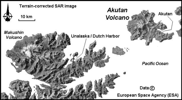 |
Figure 1. Terrain-corrected synthetic aperture radar (SAR) image showing Akutan and Makushin volcanoes in the Aleutian Islands, Alaska. Courtesy of the Alaska SAR Facility; data copyright European Space Agency. |
At about 1700 on 13 March, felt-earthquakes began occurring at a rate of greater than 1/minute, a higher rate than on 11 March. Damage associated with these earthquakes included objects tumbling off shelves, and ground shaking was again continuous. The strongest of these events were felt as far away as Dutch Harbor/Unalaska 50 km SW of Akutan. The number of earthquakes recorded in Akutan was over 800/day during the intense earthquake swarm on 13-14 March. A slight decrease in the rate of activity occurred at about 0500 on 14 March, but felt earthquakes still occurred every 2-3 minutes. There were a few earthquakes with M >= 5, and more between 4 and 5. This swarm began subsiding about 18 hours after onset. Because of the continued high seismicity AVO initiated use of a Level of Concern Color Code system and designated the current level to be Orange on 14 March, indicating an eruption was possible at any time within the next few days. On the night of 14 March, AVO's seismologist in Akutan reported 4-5 felt events.
On 15 March the rate and intensity of recorded earthquakes, although much lower than earlier in the week, remained well above background. At about 1700, a geologist flying into Akutan glimpsed a part of the N flank and summit area through broken clouds, but observed no evidence of eruptive activity. AVO scientists in Akutan felt only a few earthquakes that night. The number of earthquakes recorded on 16 March was much lower than during the swarms of 11 and 13 March. However, the rate and intensity of earthquake activity remained well above background. The weather continued to be poor, hampering visual observations. The number of daily earthquakes remained about the same through 19 March. Scientists in Akutan reported feeling only a few earthquakes each of those nights.
The Level of Concern Color Code was downgraded to Yellow on 20 March based on decreasing seismicity over the previous six days to 60-80 events/day. The Yellow code indicates that the threat of imminent eruption has declined, and the possibility that the volcano will return to quiet over a period of weeks without eruption has increased. An airline passenger reported seeing the snow-filled summit crater, with very slight normal wisps of steam from the central cinder cone, and no evidence of eruptive activity. The level of seismicity remained above background, and several earthquakes each day were felt in Akutan.
By 22 March a total of five seismic stations in four locations had been installed and all data were being sent to the Fairbanks and Anchorage laboratories in real time. Maximum separation of the stations was ~9 km. Four of the stations were located around Akutan Harbor, and the fifth was on the E slopes of the volcano about midway between the village of Akutan and the summit. The seismic array will remain in its present geometry until additional stations can be placed by helicopter this summer. By 24 March all AVO personnel had left, and around-the-clock monitoring using the new seismic stations was being conducted from AVO.
The number of earthquakes continued during 21-25 March at a rate of ~60-80/day, decreased slightly by 27 March to ~40-60/day, and remained at that level through 29 March. As of 5 April seismicity continued to slowly diminish. Earthquakes were distributed widely beneath the E half of the island with a cluster, shallower than 10 km, located ~8-10 km due E of the summit cinder cone and ~5 km W of the village of Akutan. The rate of seismicity during 6-12 April was about half that of the previous week, with ~10-20 earthquakes/day, most too small to be felt by local residents. Seismicity decreased again by half during 13-19 April, to ~5-10 small earthquakes/day.
Information Contacts: Alaska Volcano Observatory (AVO), a cooperative program of a) U.S. Geological Survey, 4200 University Drive, Anchorage, AK 99508-4667, USA (URL: http://www.avo.alaska.edu/), b) Geophysical Institute, University of Alaska, PO Box 757320, Fairbanks, AK 99775-7320, USA, and c) Alaska Division of Geological & Geophysical Surveys, 794 University Ave., Suite 200, Fairbanks, AK 99709, USA; Alaska SAR Facility, Geophysical Institute, University of Alaska Fairbanks, Fairbanks, AK 99775 USA.
Seismicity decreases and remains low
The rate of seismicity after 19 April continued to be <5 recorded earthquakes per day, a significant decrease from the number of earthquakes recorded during the seismic crisis of mid-March (BGVN 21:02 and 21:03). Background seismicity had not yet stabilized, but the small number of daily earthquakes through 3 May allowed the level of concern to be downgraded to Green at that time. The daily number of recorded earthquakes continued to be low, with some fluctuations, through 17 May.
Information Contacts: Alaska Volcano Observatory (AVO), a cooperative program of a) U.S. Geological Survey, 4200 University Drive, Anchorage, AK 99508-4667, USA (URL: http://www.avo.alaska.edu/), b) Geophysical Institute, University of Alaska, PO Box 757320, Fairbanks, AK 99775-7320, USA, and c) Alaska Division of Geological & Geophysical Surveys, 794 University Ave., Suite 200, Fairbanks, AK 99709, USA.
Low seismicity
The daily number of recorded earthquakes continued to be low (at an average rate of a few events/day) in May and June, with some fluctuations. This rate was significantly lower than the rate measured during the seismic crisis of mid-March (BGVN 21:02-21:04).
Information Contacts: Alaska Volcano Observatory (AVO), a cooperative program of a) U.S. Geological Survey, 4200 University Drive, Anchorage, AK 99508-4667, USA, b) Geophysical Institute, University of Alaska, PO Box 757320, Fairbanks, AK 99775-7320, USA, and c) Alaska Division of Geological & Geophysical Surveys.
Steaming, seismically active
We report Akutan non-eruptive seismic activity after our mid-1996 report (BGVN 21:06) through December 2010. AVO (Alaska Volcano Observatory) reporting emphasized seismicity in 2000, 2007, 2008, 2009, and 2010, including seismicity during 2007 triggered by an M 8.2 earthquake in the Kurile islands.
Background. Akutan Island is home to indigenous people located in several coastal villages, and the base of a large fish processing facility. The island resides in the Aleutian arc, a string of islands projecting ~2,000 km into the Bering Sea from the Alaskan Peninsula (figure 2).
|
Figure 2. Akutan, an island ~32 km by ~20 km, lies on the E Aleutian arc in the Bering Sea near the coast of Alaska. Courtesy of Neal and McGimsey (1996), revised by GVP. |
Akutan Island (figure 3) has a vegetated coast line dotted with spectacular bridges and caves created by the erosion of numerous lava tubes. Waythomas and others (1998) presented a map showing that much of the coastline is susceptible to rockfall avalanches and points out that these may trigger local tsunamis. The authors also analyzed the likely path of lava flows.
|
Figure 3. Akutan Island and its volcanic features, including fumaroles, hot springs, and a new steaming area. A cindercone resides in the NE quadrant of the generally circular caldera. The fumarole field, shown in red, is down slope on the E flank of the summit. The Trident seafood plant, shown as a yellow star, lays along the E coast. Courtesy of AVO, revised by GVP. |
A 2 km diameter caldera atop the 1,303 m high volcano is breached to the NW, and elsewhere encircled by crater walls 60 to 365 m high. The caldera contains a ~200 m high cinder cone, and a small lake. Fumeroles lay along the summit flank toward the E (Miller and others, 1998). The cinder cone has been the site of all historical eruptive activity (Richter and others, 1998; Waythomas and others, 1998).
The village of Akatan ( figure 4), ~ 13 km E of the volcano, hosts the Trident seafood plant, the largest such plant in North America, employing up to 900 seasonal workers (McGimsey, 2011). Akutan villagers and seafood plant employees fled the island during the 1996 seismic events (Li and others, 2000). The cited references provide many details omitted here.
|
Figure 4. Akutan coastal image with seafood plant in foreground adjacent to Akutan village. Image courtesy of AVO, created by Helena Buurman. |
According to Diefenbach and others (2009), Akutan has been the most active of the volcanoes monitored by AVO, having over 20 eruptions since 1790; more than any other Alaskan volcano.
A 2009 report by AVO noted that 11 eruptions occurred at Akutan during 1980-1992, many lasting several months (table 5). The most recent eruption started in December 2009 but the eruption's end was not clearly constrained (table 5). A seismic swarm took place in 1996, an episode without a corresponding eruption.
Table 5. Akutan eruptions tabulated from January 1980 to 2009. Courtesy of Diefenbach and others (2009).
| Start Date | End Date | VEI |
| 08 Jul 1980 | 08 Jul 1980 | 2 |
| 07 Oct 1982 | May 1983 | 2 |
| 03 Feb 1986 | 14 Jun 1986 | 2 |
| 31 Jan 1987 | 24 Jun 1987 | 2 |
| 26 Mar 1988 | 20 Jul 1988 | 2 |
| 27 Feb 1989 | 31 Mar 1989 | 2 |
| 22 Jan 1990 | 22 Jan 1990 | 2 |
| 06 Sep 1990 | 01 Oct 1990 | 2 |
| 15 Sep 1991 | 28 Nov 1991 | 2 |
| 08 Mar 1992 | 31 May 1992 | 2 |
| 18 Dec 1992 | -- | 1 |
From 1980 to 2009, Alaskan eruptions made up to 77% of the total reported in the United States (Diefenbach and others, 2009). Note that, even though during 1980-2009 Akutan erupted more times than other US volcanoes, this distinction is only one of many that can be used for comparisons. For example, in the course of that interval and the 11 recorded eruptions at Akutan, it clearly emitted less material and the eruptive intervals spanned much less time than eruptions at either Kīlauea or Mt. St. Helens.
1996 seismicity. In March 1996, two strong earthquake swarms struck the island, causing minor damage and prompting some residents and dozens of plant employees to leave the island. The seismicity, reported in BGVN 21:06, was probably the result of a magmatic intrusion (Lu and others, 2000). They stated the following:
"In March 1996 an intense swarm of volcano-tectonic earthquakes (~3,000 felt by local residents, M max = 5.1, cumulative moment of 2.7 × 10¹⁸ N m) beneath Akutan Island in the Aleutian volcanic arc, Alaska, produced extensive ground cracks but no eruption of Akutan volcano. Synthetic aperture radar interferograms that span the time of the swarm reveal complex island-wide deformation: the western part of the island including Akutan volcano moved upward, while the eastern part moved downward. The axis of the deformation approximately aligns with new ground cracks on the western part of the island and with Holocene normal faults that were reactivated during the swarm on the eastern part of the island. The axis is also roughly parallel to the direction of greatest compressional stress in the region. No ground movements greater than 2.83 cm were observed outside the volcano's summit caldera for periods of 4 years before or 2 years after the swarm. We modeled the deformation primarily as the emplacement of a shallow, E-W trending, north dipping dike plus inflation of a deep, Mogi-type [spherical] magma body beneath the volcano. The pattern of subsidence on the eastern part of the island is poorly constrained. It might have been produced by extensional tectonic strain that both reactivated preexisting faults on the eastern part of the island and facilitated magma movement beneath the western part. Alternatively, magma intrusion beneath the volcano might have been the cause of extension and subsidence in the eastern part of the island."
The 11 March 1996 swarm involved more than 80 earthquakes of M 3.0 or greater with the largest measuring M 5.2. The 13 March swarm involved more than 120 events of M 3.0 or greater with the largest measuring M 5.3 (Waythomas and others, 1998).
As a result, new ground cracks developed ( figure 5) and Waythomas and others (1998) described them as follows: "Numerous fresh, linear ground cracks were discovered in three areas on Akutan Island during field studies in the summer of 1996. Ground breaks and cracks likely formed during the strong seismic swarms in March. The ground cracks extend discontinuously from the NE side of the island near Lava Point to the island's SE side [figure 5].
"The most extensive ground cracks are between Lava Point and the volcano summit [ figure 6]. In this area, the cracks are confined to a zone 300 to 500 m wide and 3 km long. Vertical displacement of the ground surface along individual cracks is 30 to 80 cm. The ground cracks probably formed as magma moved toward the surface between the two most recently active vents on the volcano. Ground cracks on the SE side of the island occur on known faults, indicating that they probably formed in response to motion along these preexisting structures. No ground cracks were found at the head of Akutan Harbor even though this was an area where numerous earthquakes occurred from March through July, 1996."
|
Figure 5. Location of ground cracks and seismometers on Akutan, as published in 1998. Three sets of ground cracks, shown as black lines, presumably formed during the March 1996 earthquake swarm. The most extensive breaks occurred on the NW flank of the volcano near Lava Point with the other two shorter sets to the SE in line with the first. On the map, the green triangles locate seven monitoring stations, one at the summit, and others spread throughout the island as well as one at the village. Courtesy of AVO, Waythomas and others (1998), annotated by GVP. |
|
Figure 6. Ground breaks like this were found at Akutan in a zone about 300-500 m wide and ~ 3,000 m long on the NW flank of the volcano. Surface deposits offset by the cracks consist of course tephra and colluvium. The backpack in the lower left delineates scale (distant figures removed for clarity). Courtesy of AVO, Waythomas and others (1998). |
A permanent seismic network was installed during the summer of 1996 which currently consists of seven short-period stations and five broadband stations (figure 5).
Akutan seismicity, 2000 to 2010. According to AVO annual reports covering the interval 1997-2011, noteworthy seismicity occurred during the years 2000, 2007, 2008, 2009, and 2010.
On 19 January 2000, five earthquakes occurred in less than 30 minutes with epicenters 10-11 km E of the summit at hypocentral depths of ~5-6 km. This was the same region as the March 1996 volcanic swarm.
Akutan was one of several Alaska volcanoes with behavioral anomalies triggered by the M 8.2 earthquake generated in the Kurile Islands on 12 January 2007 at 0423 UTC (McGimsey, 2011). Seismologists located four of the seven largest triggered M 0.0-0.5 earthquakes at Akutan and found their depths in the range from +0.86 to -2.17 km (figure 7). The locations fell along the trend of intense seismicity and ground breakage that occurred in March 1996 at Akutan (Neal and others, 1997; Waythomas and others, 1998; Lu and others, 2005). The AVO Akutan seismic network recorded the triggered seismicity.
|
Figure 7. Epicenters at Akutan triggered by the 13 January 2007, M 8.2 Kurile Islands earthquake (the event occurred at 0423 UTC, 12 January 2007). The four largest events (red dots) lie along the same trend (blue line) as that of intense seismicity with accompanied ground breakage that occurred during dike intrusion in March 1996 (Waythomas and others, 1998). Open triangles mark locations of seismic stations. Plot of earthquake locations by John Power. Courtesy of AVO, McGimsey and others (2011). |
In early October 2007, AVO remote sensors detected signs of renewed inflation of the W flank during the previous month using GPS time series. This inflation was in the same area that inflated during the 1996 seismic crisis. A few days later, on 8 October 2007, the manager of the Trident seafood processing plant called to alert AVO of strong steaming near Hot Springs Bay (figure 8) at a spot significantly up slope from established hot springs in the valley. This plume location was considered "new" by local observers. The established lower-valley thermal springs rarely emit a concentrated, vertically rising steam plume and most earlier reports of steaming arose from the prominent fumarole field located at the 460 m elevation of the E flank at the headwaters of Hot Springs Bay valley. This is also the area of maximum deflation following the 1996 seismic swarms. No unusual seismic activity was noted for the period of W-flank inflation or the location of this steaming episode (McGimsey and others, 2011).
|
Figure 8. Midway up Akutan's Hot Springs Bay valley on the E flank of Akutan from a point well upslope of the previously active hot springs area, a steam column rises from a new site. AVO photo taken 8 October 2007 by David Abbasian. |
In 2008, over 100 seismic events were recorded. During the next two years, Akutan seismic events decreased to about half that number. During 2010 low frequency earthquakes doubled compared to 2009 (Table 6).
Table 6. Akutan seismic activity for 2008-2010 compiled from AVO/USGS annual reports. Total earthquakes (in the second column) summed those in the Volcano-tectonic and Low frequency columns. '--' indicates data not reported. Courtesy of AVO.
| Year | Total earthquakes | Volcano-tectonic | Low-frequency |
| 2008 | 105 | -- | -- |
| 2009 | 45 | 41 | 4 |
| 2010 | 42 | 34 | 8 |
According to AVO, Akutan seismic events during the years 2009 and 2010 were temporally spread roughly throughout the months except for a tight cluster of M 2 earthquakes reported at depths of between ~5 km to ~10 km during the first weeks of January 2010. The majority of earthquakes in 2010 were located within ~5 km of the crater along a N-trending line spanning 10 km. In 2009 the spread was longer, over 20 km.
References. Diefenbach, A.K., Guffanti, M., and Ewert, J.W., 2009, Chronology and references of volcanic eruptions and selected unrest in the United States, 1980-2008: U.S. Geological Survey Open-File Report 2009-1118, 85 p. [http://pubs.usgs.gov/of/2009/1118/].
Dixon, J.P., Stihler, S.D., Power, J.A., and Searcy, C.K., 2010, Catalog of Earthquake Hypocenters at Alaskan Volcanoes: January 1 through December 31, 2009: U.S. Geological Survey Data Series 531.
Dixon, J.P., Stihler, S.D., Power, J.A., and Searcy, C.K., 2011, Catalog of earthquake hypocenters at Alaskan Volcanoes: January 1 through December 31, 2010: U.S. Geological Survey Data Series 645.
Kent, T., 2011, Hydrothermal Alteration of Open Fractures in Prospective Geothermal Drill Cores, Akutan Island, Alaska, Fall Meeting of the American Geophysical Union, 2011, Abstract ##V13D-2637.
Lu, Z., Wicks Jr., C., Power, J.A., and Dzurisin, D., 2000, Ground deformation associated with the March 1996 earthquake swarm at Akutan volcano, Alaska, revealed by satellite radar interferometry, J. Geophys. Res., 105(B9), 21,483-21,495 (DOI:10.1029/2000JB900200).
Miller, T.P., McGimsey, R.G., Richter, D.H., Riehle, J.R., Nye, C.J., Yount, M.E., and Dumoulin, J.A., 1998, Catalog of the historically active volcanoes of Alaska: U.S. Geological Survey Open-File Report 98-582, 104 p. (Also available at http://www.avo.alaska.edu/downloads/catalog.php.)
McGimsey, R.G., Neal, C.A., Dixon, J.P., Malik, Nataliya, and Chibisova, M., 2011, 2007 Volcanic activity in Alaska, Kamchatka, and the Kurile Islands: Summary of events and response of the Alaska Volcano Observatory: U.S. Geological Survey Scientific Investigations Report 2010-5242, 110 p.
Neal, C.A. and McGimsey, R.G., 1997, 1996 Volcanic Activity In Alaska And Kamchatka: Summary Of Events And Response Of The Alaska Volcano Observatory: U.S. Geological Survey Open-File Report 97-433.
Richter, D.H., Waythomas, C.F., McGimsey, R.G., and Stelling, P.L., 1998, Geologic map of Akutan Island, Alaska: U.S. Geological Survey Open-File Report 98-135, 22 p., 1 plate.
Waythomas, C.F., Power, J.A., Richter, D.H., and McGimsey, R.G., 1998, Preliminary volcano-hazard assessment for Akutan Volcano east-central Aleutian Islands, Alaska: U.S. Geological Survey Open-File Report 98-0360, 36 p., 1 plate.
Information Contacts: Alaska Volcano Observatory (AVO), a cooperative program of a) U.S. Geological Survey, 4200 University Drive, Anchorage, AK 99508-4667, USA, b) Geophysical Institute, University of Alaska, PO Box 757320, Fairbanks, AK 99775-7320, USA, and c) Alaska Division of Geological & Geophysical Surveys.
|
|
||||||||||||||||||||||||||||
There is data available for 40 confirmed eruptive periods.
1992 Dec 18 - 1992 Dec 18 Confirmed Eruption (Explosive / Effusive) VEI: 1
| Episode 1 | Eruption (Explosive / Effusive) | ||||||||||||||||||||||||
|---|---|---|---|---|---|---|---|---|---|---|---|---|---|---|---|---|---|---|---|---|---|---|---|---|
| 1992 Dec 18 - 1992 Dec 18 | Evidence from Observations: Reported | |||||||||||||||||||||||
| AVO reported that a small ash cloud rose to a maximum altitude of 1.8 km (several hundred meters above the summit) shortly after 1445 on 18 December 1992. The plume was carried ~20 km N, then rapidly dissipated. | ||||||||||||||||||||||||
|
List of 3 Events for Episode 1
|
||||||||||||||||||||||||
1992 Mar 8 - 1992 May 21 Confirmed Eruption (Explosive / Effusive) VEI: 2
| Episode 1 | Eruption (Explosive / Effusive) | |||||||||||||||||||||||||||||
|---|---|---|---|---|---|---|---|---|---|---|---|---|---|---|---|---|---|---|---|---|---|---|---|---|---|---|---|---|---|
| 1992 Mar 8 - 1992 May 21 | Evidence from Observations: Reported | ||||||||||||||||||||||||||||
|
List of 4 Events for Episode 1
|
|||||||||||||||||||||||||||||
1991 Sep 15 - 1991 Oct 29 ± 1 days Confirmed Eruption (Explosive / Effusive) VEI: 2
| Episode 1 | Eruption (Explosive / Effusive) | ||||||||||||||||||||||||
|---|---|---|---|---|---|---|---|---|---|---|---|---|---|---|---|---|---|---|---|---|---|---|---|---|
| 1991 Sep 15 - 1991 Oct 29 ± 1 days | Evidence from Observations: Reported | |||||||||||||||||||||||
|
List of 3 Events for Episode 1
|
||||||||||||||||||||||||
1990 Sep 6 - 1990 Oct 1 Confirmed Eruption (Explosive / Effusive) VEI: 2
| Episode 1 | Eruption (Explosive / Effusive) | ||||||||||||||||||||||||
|---|---|---|---|---|---|---|---|---|---|---|---|---|---|---|---|---|---|---|---|---|---|---|---|---|
| 1990 Sep 6 - 1990 Oct 1 | Evidence from Observations: Reported | |||||||||||||||||||||||
|
List of 3 Events for Episode 1
|
||||||||||||||||||||||||
1990 Jan 26 ± 5 days - 1990 Jan 26 ± 5 days Confirmed Eruption (Explosive / Effusive) VEI: 2
| Episode 1 | Eruption (Explosive / Effusive) | ||||||||||||||||||||||||
|---|---|---|---|---|---|---|---|---|---|---|---|---|---|---|---|---|---|---|---|---|---|---|---|---|
| 1990 Jan 26 ± 5 days - 1990 Jan 26 ± 5 days | Evidence from Observations: Reported | |||||||||||||||||||||||
|
List of 3 Events for Episode 1
|
||||||||||||||||||||||||
1989 Feb 27 - 1989 Mar 28 (on or before) Confirmed Eruption (Explosive / Effusive) VEI: 2
| Episode 1 | Eruption (Explosive / Effusive) | ||||||||||||||||||||||||
|---|---|---|---|---|---|---|---|---|---|---|---|---|---|---|---|---|---|---|---|---|---|---|---|---|
| 1989 Feb 27 - 1989 Mar 28 (on or before) | Evidence from Observations: Reported | |||||||||||||||||||||||
|
List of 3 Events for Episode 1
|
||||||||||||||||||||||||
1988 Mar 26 - 1988 Jul 20 Confirmed Eruption (Explosive / Effusive) VEI: 2
| Episode 1 | Eruption (Explosive / Effusive) | ||||||||||||||||||||||||
|---|---|---|---|---|---|---|---|---|---|---|---|---|---|---|---|---|---|---|---|---|---|---|---|---|
| 1988 Mar 26 - 1988 Jul 20 | Evidence from Observations: Reported | |||||||||||||||||||||||
|
List of 3 Events for Episode 1
|
||||||||||||||||||||||||
1987 Jan 31 - 1987 Jun 24 Confirmed Eruption (Explosive / Effusive) VEI: 2
| Episode 1 | Eruption (Explosive / Effusive) | |||||||||||||||||||||||||||||
|---|---|---|---|---|---|---|---|---|---|---|---|---|---|---|---|---|---|---|---|---|---|---|---|---|---|---|---|---|---|
| 1987 Jan 31 - 1987 Jun 24 | Evidence from Observations: Reported | ||||||||||||||||||||||||||||
|
List of 4 Events for Episode 1
|
|||||||||||||||||||||||||||||
1986 Mar 18 - 1986 Jun 30 Confirmed Eruption (Explosive / Effusive) VEI: 2
| Episode 1 | Eruption (Explosive / Effusive) | |||||||||||||||||||||||||||||
|---|---|---|---|---|---|---|---|---|---|---|---|---|---|---|---|---|---|---|---|---|---|---|---|---|---|---|---|---|---|
| 1986 Mar 18 - 1986 Jun 30 | Evidence from Observations: Reported | ||||||||||||||||||||||||||||
|
List of 4 Events for Episode 1
|
|||||||||||||||||||||||||||||
1982 Oct 5 ± 4 days - 1983 May 16 ± 15 days Confirmed Eruption (Explosive / Effusive) VEI: 2
| Episode 1 | Eruption (Explosive / Effusive) | ||||||||||||||||||||||||
|---|---|---|---|---|---|---|---|---|---|---|---|---|---|---|---|---|---|---|---|---|---|---|---|---|
| 1982 Oct 5 ± 4 days - 1983 May 16 ± 15 days | Evidence from Observations: Reported | |||||||||||||||||||||||
|
List of 3 Events for Episode 1
|
||||||||||||||||||||||||
1980 Jul 3 (on or before) - 1980 Jul 8 (?) Confirmed Eruption (Explosive / Effusive) VEI: 2
| Episode 1 | Eruption (Explosive / Effusive) | ||||||||||||||||||||||||
|---|---|---|---|---|---|---|---|---|---|---|---|---|---|---|---|---|---|---|---|---|---|---|---|---|
| 1980 Jul 3 (on or before) - 1980 Jul 8 (?) | Evidence from Observations: Reported | |||||||||||||||||||||||
|
List of 3 Events for Episode 1
|
||||||||||||||||||||||||
1978 Sep 25 ± 5 days - 1978 Oct 16 ± 15 days Confirmed Eruption (Explosive / Effusive) VEI: 2
| Episode 1 | Eruption (Explosive / Effusive) | |||||||||||||||||||||||||||||||||||||||
|---|---|---|---|---|---|---|---|---|---|---|---|---|---|---|---|---|---|---|---|---|---|---|---|---|---|---|---|---|---|---|---|---|---|---|---|---|---|---|---|
| 1978 Sep 25 ± 5 days - 1978 Oct 16 ± 15 days | Evidence from Observations: Reported | ||||||||||||||||||||||||||||||||||||||
|
List of 6 Events for Episode 1
|
|||||||||||||||||||||||||||||||||||||||
1976 Oct 15 ± 45 days - 1977 May 9 (on or after) Confirmed Eruption (Explosive / Effusive) VEI: 2
| Episode 1 | Eruption (Explosive / Effusive) | ||||||||||||||||||||||||
|---|---|---|---|---|---|---|---|---|---|---|---|---|---|---|---|---|---|---|---|---|---|---|---|---|
| 1976 Oct 15 ± 45 days - 1977 May 9 (on or after) | Evidence from Observations: Reported | |||||||||||||||||||||||
|
List of 3 Events for Episode 1
|
||||||||||||||||||||||||
1974 Feb 11 (on or before) Confirmed Eruption (Explosive / Effusive) VEI: 2
| Episode 1 | Eruption (Explosive / Effusive) | West flank ? | ||||||||||||||||||||||||||||
|---|---|---|---|---|---|---|---|---|---|---|---|---|---|---|---|---|---|---|---|---|---|---|---|---|---|---|---|---|---|
| 1974 Feb 11 (on or before) - Unknown | Evidence from Observations: Reported | ||||||||||||||||||||||||||||
|
List of 4 Events for Episode 1 at West flank ?
|
|||||||||||||||||||||||||||||
1973 Mar 16 (?) ± 15 days - 1973 May 16 ± 15 days Confirmed Eruption (Explosive / Effusive) VEI: 2
| Episode 1 | Eruption (Explosive / Effusive) | ||||||||||||||||||||||||
|---|---|---|---|---|---|---|---|---|---|---|---|---|---|---|---|---|---|---|---|---|---|---|---|---|
| 1973 Mar 16 (?) ± 15 days - 1973 May 16 ± 15 days | Evidence from Observations: Reported | |||||||||||||||||||||||
|
List of 3 Events for Episode 1
|
||||||||||||||||||||||||
[ 1972 Sep 16 (?) ± 15 days ] Uncertain Eruption
| Episode 1 | Eruption (Explosive / Effusive) | |||||||||||||||||||
|---|---|---|---|---|---|---|---|---|---|---|---|---|---|---|---|---|---|---|---|
| 1972 Sep 16 (?) ± 15 days - Unknown | Evidence from Unknown | ||||||||||||||||||
|
List of 2 Events for Episode 1
|
|||||||||||||||||||
1962 Nov 5 ± 4 days Confirmed Eruption (Explosive / Effusive) VEI: 2
| Episode 1 | Eruption (Explosive / Effusive) | ||||||||||||||||||||||||
|---|---|---|---|---|---|---|---|---|---|---|---|---|---|---|---|---|---|---|---|---|---|---|---|---|
| 1962 Nov 5 ± 4 days - Unknown | Evidence from Observations: Reported | |||||||||||||||||||||||
|
List of 3 Events for Episode 1
|
||||||||||||||||||||||||
1953 Jul 2 ± 182 days Confirmed Eruption (Explosive / Effusive) VEI: 2
| Episode 1 | Eruption (Explosive / Effusive) | ||||||||||||||||||||||||
|---|---|---|---|---|---|---|---|---|---|---|---|---|---|---|---|---|---|---|---|---|---|---|---|---|
| 1953 Jul 2 ± 182 days - Unknown | Evidence from Observations: Reported | |||||||||||||||||||||||
|
List of 3 Events for Episode 1
|
||||||||||||||||||||||||
1951 Oct 16 ± 15 days Confirmed Eruption (Explosive / Effusive) VEI: 2
| Episode 1 | Eruption (Explosive / Effusive) | ||||||||||||||||||||||||
|---|---|---|---|---|---|---|---|---|---|---|---|---|---|---|---|---|---|---|---|---|---|---|---|---|
| 1951 Oct 16 ± 15 days - Unknown | Evidence from Observations: Reported | |||||||||||||||||||||||
|
List of 3 Events for Episode 1
|
||||||||||||||||||||||||
1948 Apr 29 - 1948 Aug 7 (on or after) Confirmed Eruption (Explosive / Effusive) VEI: 2
| Episode 1 | Eruption (Explosive / Effusive) | |||||||||||||||||||||||||||||||||||||||
|---|---|---|---|---|---|---|---|---|---|---|---|---|---|---|---|---|---|---|---|---|---|---|---|---|---|---|---|---|---|---|---|---|---|---|---|---|---|---|---|
| 1948 Apr 29 - 1948 Aug 7 (on or after) | Evidence from Observations: Reported | ||||||||||||||||||||||||||||||||||||||
|
List of 6 Events for Episode 1
|
|||||||||||||||||||||||||||||||||||||||
1946 Dec - 1947 Jan Confirmed Eruption (Explosive / Effusive) VEI: 2
| Episode 1 | Eruption (Explosive / Effusive) | |||||||||||||||||||||||||||||
|---|---|---|---|---|---|---|---|---|---|---|---|---|---|---|---|---|---|---|---|---|---|---|---|---|---|---|---|---|---|
| 1946 Dec - 1947 Jan | Evidence from Observations: Reported | ||||||||||||||||||||||||||||
|
List of 4 Events for Episode 1
|
|||||||||||||||||||||||||||||
1931 May - 1931 Aug Confirmed Eruption (Explosive / Effusive) VEI: 2
| Episode 1 | Eruption (Explosive / Effusive) | ||||||||||||||||||||||||
|---|---|---|---|---|---|---|---|---|---|---|---|---|---|---|---|---|---|---|---|---|---|---|---|---|
| 1931 May - 1931 Aug | Evidence from Observations: Reported | |||||||||||||||||||||||
|
List of 3 Events for Episode 1
|
||||||||||||||||||||||||
1929 May (?) Confirmed Eruption (Explosive / Effusive) VEI: 2
| Episode 1 | Eruption (Explosive / Effusive) | ||||||||||||||||||||||||||||||||||
|---|---|---|---|---|---|---|---|---|---|---|---|---|---|---|---|---|---|---|---|---|---|---|---|---|---|---|---|---|---|---|---|---|---|---|
| 1929 May (?) - Unknown | Evidence from Observations: Reported | |||||||||||||||||||||||||||||||||
|
List of 5 Events for Episode 1
|
||||||||||||||||||||||||||||||||||
1927 - 1928 Confirmed Eruption (Explosive / Effusive) VEI: 2
| Episode 1 | Eruption (Explosive / Effusive) | |||||||||||||||||||||||||||||
|---|---|---|---|---|---|---|---|---|---|---|---|---|---|---|---|---|---|---|---|---|---|---|---|---|---|---|---|---|---|
| 1927 - 1928 | Evidence from Observations: Reported | ||||||||||||||||||||||||||||
|
List of 4 Events for Episode 1
|
|||||||||||||||||||||||||||||
[ 1912 ] Uncertain Eruption
| Episode 1 | Eruption (Explosive / Effusive) | ||||||||||||||
|---|---|---|---|---|---|---|---|---|---|---|---|---|---|---|
| 1912 - Unknown | Evidence from Unknown | |||||||||||||
|
List of 1 Events for Episode 1
|
||||||||||||||
1911 Confirmed Eruption (Explosive / Effusive) VEI: 2
| Episode 1 | Eruption (Explosive / Effusive) | ||||||||||||||||||||||||
|---|---|---|---|---|---|---|---|---|---|---|---|---|---|---|---|---|---|---|---|---|---|---|---|---|
| 1911 - Unknown | Evidence from Observations: Reported | |||||||||||||||||||||||
|
List of 3 Events for Episode 1
|
||||||||||||||||||||||||
1908 Feb 22 Confirmed Eruption (Explosive / Effusive) VEI: 0
| Episode 1 | Eruption (Explosive / Effusive) | |||||||||||||||||||
|---|---|---|---|---|---|---|---|---|---|---|---|---|---|---|---|---|---|---|---|
| 1908 Feb 22 - Unknown | Evidence from Observations: Reported | ||||||||||||||||||
|
List of 2 Events for Episode 1
|
|||||||||||||||||||
1907 Confirmed Eruption (Explosive / Effusive)
| Episode 1 | Eruption (Explosive / Effusive) | ||||
|---|---|---|---|---|
| 1907 - Unknown | Evidence from Observations: Reported | |||
1896 Confirmed Eruption (Explosive / Effusive)
| Episode 1 | Eruption (Explosive / Effusive) | ||||||||||||||
|---|---|---|---|---|---|---|---|---|---|---|---|---|---|---|
| 1896 - Unknown | Evidence from Observations: Reported | |||||||||||||
|
List of 1 Events for Episode 1
|
||||||||||||||
1895 Aug 1 - 1895 Aug 14 Confirmed Eruption (Explosive / Effusive) VEI: 2
| Episode 1 | Eruption (Explosive / Effusive) | ||||||||||||||||||||||||
|---|---|---|---|---|---|---|---|---|---|---|---|---|---|---|---|---|---|---|---|---|---|---|---|---|
| 1895 Aug 1 - 1895 Aug 14 | Evidence from Observations: Reported | |||||||||||||||||||||||
|
List of 3 Events for Episode 1
|
||||||||||||||||||||||||
1892 Sep 23 Confirmed Eruption (Explosive / Effusive) VEI: 1
| Episode 1 | Eruption (Explosive / Effusive) | ||||||||||||||||||||||||
|---|---|---|---|---|---|---|---|---|---|---|---|---|---|---|---|---|---|---|---|---|---|---|---|---|
| 1892 Sep 23 - Unknown | Evidence from Observations: Reported | |||||||||||||||||||||||
|
List of 3 Events for Episode 1
|
||||||||||||||||||||||||
1887 Confirmed Eruption (Explosive / Effusive) VEI: 0
| Episode 1 | Eruption (Explosive / Effusive) | |||||||||||||||||||
|---|---|---|---|---|---|---|---|---|---|---|---|---|---|---|---|---|---|---|---|
| 1887 - Unknown | Evidence from Observations: Reported | ||||||||||||||||||
|
List of 2 Events for Episode 1
|
|||||||||||||||||||
1883 Confirmed Eruption (Explosive / Effusive) VEI: 2
| Episode 1 | Eruption (Explosive / Effusive) | ||||||||||||||||||||||||
|---|---|---|---|---|---|---|---|---|---|---|---|---|---|---|---|---|---|---|---|---|---|---|---|---|
| 1883 - Unknown | Evidence from Observations: Reported | |||||||||||||||||||||||
|
List of 3 Events for Episode 1
|
||||||||||||||||||||||||
1867 Confirmed Eruption (Explosive / Effusive)
| Episode 1 | Eruption (Explosive / Effusive) | ||||||||||||||||||||||||
|---|---|---|---|---|---|---|---|---|---|---|---|---|---|---|---|---|---|---|---|---|---|---|---|---|
| 1867 - Unknown | Evidence from Observations: Reported | |||||||||||||||||||||||
|
List of 3 Events for Episode 1
|
||||||||||||||||||||||||
1865 Confirmed Eruption (Explosive / Effusive)
| Episode 1 | Eruption (Explosive / Effusive) | ||||||||||||||
|---|---|---|---|---|---|---|---|---|---|---|---|---|---|---|
| 1865 - Unknown | Evidence from Observations: Reported | |||||||||||||
|
List of 1 Events for Episode 1
|
||||||||||||||
[ 1862 ] Uncertain Eruption
| Episode 1 | Eruption (Explosive / Effusive) | ||||||||||||||
|---|---|---|---|---|---|---|---|---|---|---|---|---|---|---|
| 1862 - Unknown | Evidence from Unknown | |||||||||||||
|
List of 1 Events for Episode 1
|
||||||||||||||
1852 Confirmed Eruption (Explosive / Effusive)
| Episode 1 | Eruption (Explosive / Effusive) | NW flank (Lava Point) | |||||||||||||||||||||||
|---|---|---|---|---|---|---|---|---|---|---|---|---|---|---|---|---|---|---|---|---|---|---|---|---|
| 1852 - Unknown | Evidence from Observations: Reported | |||||||||||||||||||||||
|
List of 3 Events for Episode 1 at NW flank (Lava Point)
|
||||||||||||||||||||||||
1848 Mar 5 ± 4 days Confirmed Eruption (Explosive / Effusive) VEI: 2
| Episode 1 | Eruption (Explosive / Effusive) | |||||||||||||||||||||||||||||||||||||||
|---|---|---|---|---|---|---|---|---|---|---|---|---|---|---|---|---|---|---|---|---|---|---|---|---|---|---|---|---|---|---|---|---|---|---|---|---|---|---|---|
| 1848 Mar 5 ± 4 days - Unknown | Evidence from Observations: Reported | ||||||||||||||||||||||||||||||||||||||
|
List of 6 Events for Episode 1
|
|||||||||||||||||||||||||||||||||||||||
[ 1845 ] Uncertain Eruption
| Episode 1 | Eruption (Explosive / Effusive) | ||||||||||||||
|---|---|---|---|---|---|---|---|---|---|---|---|---|---|---|
| 1845 - Unknown | Evidence from Unknown | |||||||||||||
|
List of 1 Events for Episode 1
|
||||||||||||||
[ 1838 ] Uncertain Eruption
| Episode 1 | Eruption (Explosive / Effusive) | ||||||||||||||
|---|---|---|---|---|---|---|---|---|---|---|---|---|---|---|
| 1838 - Unknown | Evidence from Unknown | |||||||||||||
|
List of 1 Events for Episode 1
|
||||||||||||||
[ 1828 ] Uncertain Eruption
| Episode 1 | Eruption (Explosive / Effusive) | ||||||||||||||
|---|---|---|---|---|---|---|---|---|---|---|---|---|---|---|
| 1828 - Unknown | Evidence from Unknown | |||||||||||||
|
List of 1 Events for Episode 1
|
||||||||||||||
[ 1790 ] Uncertain Eruption
| Episode 1 | Eruption (Explosive / Effusive) | ||||||||||||||
|---|---|---|---|---|---|---|---|---|---|---|---|---|---|---|
| 1790 - Unknown | Evidence from Unknown | |||||||||||||
|
List of 1 Events for Episode 1
|
||||||||||||||
1420 ± 100 years Confirmed Eruption (Explosive / Effusive)
| Episode 1 | Eruption (Explosive / Effusive) | ||||||||||||||||||||||||
|---|---|---|---|---|---|---|---|---|---|---|---|---|---|---|---|---|---|---|---|---|---|---|---|---|
| 1420 ± 100 years - Unknown | Evidence from Isotopic: 14C (calibrated) | |||||||||||||||||||||||
|
List of 3 Events for Episode 1
|
||||||||||||||||||||||||
0550 (?) Confirmed Eruption (Explosive / Effusive)
| Episode 1 | Eruption (Explosive / Effusive) | |||||||||||||||||||
|---|---|---|---|---|---|---|---|---|---|---|---|---|---|---|---|---|---|---|---|
| 0550 (?) - Unknown | Evidence from Isotopic: 14C (uncalibrated) | ||||||||||||||||||
|
List of 2 Events for Episode 1
|
|||||||||||||||||||
0340 (?) Confirmed Eruption (Explosive / Effusive) VEI: 5
| Episode 1 | Eruption (Explosive / Effusive) | |||||||||||||||||||||||||||||
|---|---|---|---|---|---|---|---|---|---|---|---|---|---|---|---|---|---|---|---|---|---|---|---|---|---|---|---|---|---|
| 0340 (?) - Unknown | Evidence from Isotopic: 14C (uncalibrated) | ||||||||||||||||||||||||||||
|
List of 4 Events for Episode 1
|
|||||||||||||||||||||||||||||
4150 BCE (?) Confirmed Eruption (Explosive / Effusive)
| Episode 1 | Eruption (Explosive / Effusive) | ||||||||||||||||||||||||
|---|---|---|---|---|---|---|---|---|---|---|---|---|---|---|---|---|---|---|---|---|---|---|---|---|
| 4150 BCE (?) - Unknown | Evidence from Isotopic: 14C (uncalibrated) | |||||||||||||||||||||||
|
List of 3 Events for Episode 1
|
||||||||||||||||||||||||
7620 BCE ± 300 years Confirmed Eruption (Explosive / Effusive)
| Episode 1 | Eruption (Explosive / Effusive) | ||||||||||||||||||||||||
|---|---|---|---|---|---|---|---|---|---|---|---|---|---|---|---|---|---|---|---|---|---|---|---|---|
| 7620 BCE ± 300 years - Unknown | Evidence from Isotopic: 14C (calibrated) | |||||||||||||||||||||||
|
List of 3 Events for Episode 1
|
||||||||||||||||||||||||
This compilation of synonyms and subsidiary features may not be comprehensive. Features are organized into four major categories: Cones, Craters, Domes, and Thermal Features. Synonyms of features appear indented below the primary name. In some cases additional feature type, elevation, or location details are provided.
Cones |
||||
| Feature Name | Feature Type | Elevation | Latitude | Longitude |
| Lava Peak | Cone | |||
| Lava Point | Cone | |||
Thermal |
||||
| Feature Name | Feature Type | Elevation | Latitude | Longitude |
| Hot Springs Bay | Hot Spring | 54° 8' 55.00" N | 165° 51' 43.00" W | |
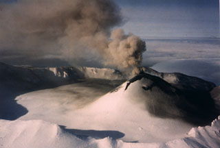 Intermittent explosive eruptions took place from the scoria cone in Akutan caldera during 31 January-2 March and 22-24 June 1987. This 11 February photo from the SE shows an ash plume rising from a crater at the top of the cone. Ash was deposited across the cone flank and the N side of the caldera floor.
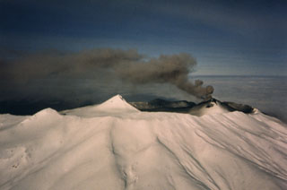 Akutan has a 2-km-wide summit caldera with a large scoria cone that rises above the caldera rim. It is seen here from the south in eruption on 11 February 1987. A small lake occupies part of the caldera floor. The caldera rim is breached narrowly on the north side through which a 1978 lava flow traveled to within 2 km of the sea.
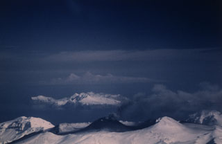 An ash plume rises above the scoria cone in the Akutan summit caldera of on 2 March 1987. This view from the WSW shows Mount Gilbert, a Pleistocene volcano on Akun Island and the peaks of Westdahl, Shishaldin, and Isanotski (left to right) on distant Unimak Island.
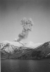 An ash plume rises about 1.5 km above the scoria cone in the Akutan summit caldera on 20 April 1988. This view from Akutan Harbor east of the volcano shows typical explosive activity. Intermittent ash eruptions began on 26 March and continued until 20 July.
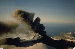 An ash plume rises about 1 km and drifts to the NW above the Akutan caldera scoria cone on 2 June 1988. Dark ash deposits on the flanks extend across the caldera floor and western rim. The snow-covered ridge in the foreground is the SW caldera rim. Intermittent eruptions such as these are typical of Akutan. The 1988 eruption lasted from 26 March to 20 July.
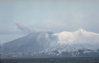 Akutan forms the west-central part of Akutan Island in the eastern Aleutians. The summit contains a 2-km-wide caldera with a large scoria cone, visible here through a low point in the northern caldera rim. The cone has been the site of frequent historical eruptive activity.
There are no samples for Akutan in the Smithsonian's NMNH Department of Mineral Sciences Rock and Ore collection.
| Alaska Volcano Observatory (Link to Akutan) | The Alaska Volcano Observatory (AVO) is a joint program of the U.S. Geological Survey (USGS), the Geophysical Institute of the University of Alaska Fairbanks (UAFGI), and the State of Alaska Division of Geological and Geophysical Surveys (ADGGS). AVO was formed in 1988, and uses federal, state, and university resources to monitor and study Alaska's hazardous volcanoes, to predict and record eruptive activity, and to mitigate volcanic hazards to life and property. |
| Copernicus Browser | The Copernicus Browser replaced the Sentinel Hub Playground browser in 2023, to provide access to Earth observation archives from the Copernicus Data Space Ecosystem, the main distribution platform for data from the EU Copernicus missions. |
| MIROVA | Middle InfraRed Observation of Volcanic Activity (MIROVA) is a near real time volcanic hot-spot detection system based on the analysis of MODIS (Moderate Resolution Imaging Spectroradiometer) data. In particular, MIROVA uses the Middle InfraRed Radiation (MIR), measured over target volcanoes, in order to detect, locate and measure the heat radiation sourced from volcanic activity. |
| MODVOLC Thermal Alerts | Using infrared satellite Moderate Resolution Imaging Spectroradiometer (MODIS) data, scientists at the Hawai'i Institute of Geophysics and Planetology, University of Hawai'i, developed an automated system called MODVOLC to map thermal hot-spots in near real time. For each MODIS image, the algorithm automatically scans each 1 km pixel within it to check for high-temperature hot-spots. When one is found the date, time, location, and intensity are recorded. MODIS looks at every square km of the Earth every 48 hours, once during the day and once during the night, and the presence of two MODIS sensors in space allows at least four hot-spot observations every two days. Each day updated global maps are compiled to display the locations of all hot spots detected in the previous 24 hours. There is a drop-down list with volcano names which allow users to 'zoom-in' and examine the distribution of hot-spots at a variety of spatial scales. |
|
WOVOdat
Single Volcano View Temporal Evolution of Unrest Side by Side Volcanoes |
WOVOdat is a database of volcanic unrest; instrumentally and visually recorded changes in seismicity, ground deformation, gas emission, and other parameters from their normal baselines. It is sponsored by the World Organization of Volcano Observatories (WOVO) and presently hosted at the Earth Observatory of Singapore.
GVMID Data on Volcano Monitoring Infrastructure The Global Volcano Monitoring Infrastructure Database GVMID, is aimed at documenting and improving capabilities of volcano monitoring from the ground and space. GVMID should provide a snapshot and baseline view of the techniques and instrumentation that are in place at various volcanoes, which can be use by volcano observatories as reference to setup new monitoring system or improving networks at a specific volcano. These data will allow identification of what monitoring gaps exist, which can be then targeted by remote sensing infrastructure and future instrument deployments. |
| Volcanic Hazard Maps | The IAVCEI Commission on Volcanic Hazards and Risk has a Volcanic Hazard Maps database designed to serve as a resource for hazard mappers (or other interested parties) to explore how common issues in hazard map development have been addressed at different volcanoes, in different countries, for different hazards, and for different intended audiences. In addition to the comprehensive, searchable Volcanic Hazard Maps Database, this website contains information about diversity of volcanic hazard maps, illustrated using examples from the database. This site is for educational purposes related to volcanic hazard maps. Hazard maps found on this website should not be used for emergency purposes. For the most recent, official hazard map for a particular volcano, please seek out the proper institutional authorities on the matter. |
| IRIS seismic stations/networks | Incorporated Research Institutions for Seismology (IRIS) Data Services map showing the location of seismic stations from all available networks (permanent or temporary) within a radius of 0.18° (about 20 km at mid-latitudes) from the given location of Akutan. Users can customize a variety of filters and options in the left panel. Note that if there are no stations are known the map will default to show the entire world with a "No data matched request" error notice. |
| UNAVCO GPS/GNSS stations | Geodetic Data Services map from UNAVCO showing the location of GPS/GNSS stations from all available networks (permanent or temporary) within a radius of 20 km from the given location of Akutan. Users can customize the data search based on station or network names, location, and time window. Requires Adobe Flash Player. |
| DECADE Data | The DECADE portal, still in the developmental stage, serves as an example of the proposed interoperability between The Smithsonian Institution's Global Volcanism Program, the Mapping Gas Emissions (MaGa) Database, and the EarthChem Geochemical Portal. The Deep Earth Carbon Degassing (DECADE) initiative seeks to use new and established technologies to determine accurate global fluxes of volcanic CO2 to the atmosphere, but installing CO2 monitoring networks on 20 of the world's 150 most actively degassing volcanoes. The group uses related laboratory-based studies (direct gas sampling and analysis, melt inclusions) to provide new data for direct degassing of deep earth carbon to the atmosphere. |
| Large Eruptions of Akutan | Information about large Quaternary eruptions (VEI >= 4) is cataloged in the Large Magnitude Explosive Volcanic Eruptions (LaMEVE) database of the Volcano Global Risk Identification and Analysis Project (VOGRIPA). |
| EarthChem | EarthChem develops and maintains databases, software, and services that support the preservation, discovery, access and analysis of geochemical data, and facilitate their integration with the broad array of other available earth science parameters. EarthChem is operated by a joint team of disciplinary scientists, data scientists, data managers and information technology developers who are part of the NSF-funded data facility Integrated Earth Data Applications (IEDA). IEDA is a collaborative effort of EarthChem and the Marine Geoscience Data System (MGDS). |