Report on Semeru (Indonesia) — October 1992

Bulletin of the Global Volcanism Network, vol. 17, no. 10 (October 1992)
Managing Editor: Lindsay McClelland.
Semeru (Indonesia) Frequent explosions eject 1-km clouds; summit morphology described
Please cite this report as:
Global Volcanism Program, 1992. Report on Semeru (Indonesia) (McClelland, L., ed.). Bulletin of the Global Volcanism Network, 17:10. Smithsonian Institution. https://doi.org/10.5479/si.GVP.BGVN199210-263300
Semeru
Indonesia
8.108°S, 112.922°E; summit elev. 3657 m
All times are local (unless otherwise noted)
During an 18-hour visit to the summit region 21-22 October by the German-Indonesian Volcano Expedition, volcanic activity was confined to the Jonggring Seloko crater (figures 2 and 3). At least 35 explosions occurred during the summit visit, most associated with steam releases from the crater bottom, sometimes forming mushroom-shaped clouds that rose ~1 km above the crater. The average time between explosions was ~22 minutes, but varied between 3 and 46 minutes.
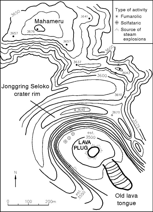 |
Figure 2. Sketch of the summit region of Semeru. The northern part of this sketch is taken from the 1941 map in Reksowirogo (1979). Relative altitude measurements taken in 1992 at the locations shown agree well with the 1941 map. The southern area is sketched from the 1992 observations. Elevations given were measured relative to the summit. All other contour lines and distances are estimates. Contour interval (heavy lines) is 25 m; intermediate contours at 12.5 m intervals are included on part of the map. Although individual values may not be exact, the sketch accurately reconstructs the summit morphology. Courtesy of Margaret Hellweg. |
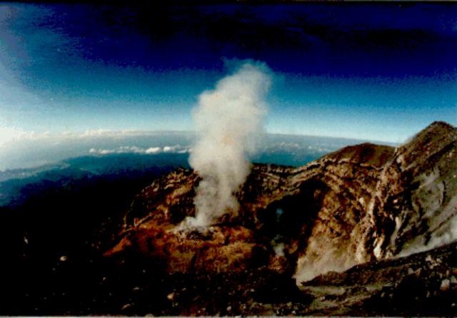 |
Figure 3. Photograph of the Jonggring Seloko crater of Semeru, 21 October 1992, taken from the N crater rim. Alternating layers of lava and ash can be seen in the crater walls; steam is rising from the lava dome. The crater, open to the SE, is ~300 m in diameter and 150 m deep. The S coast of Java is visible at left center. [Photograph taken by Horst Rademacher; originally in 19:1.] |
One phase of activity that could not be correlated with the release of steam from any particular fumarole was a rhythmic, puffing sound emitted from the bottom of the crater. The sound was reminiscent of a steam locomotive starting to pull a heavy freight train. The frequency of the "puffs" ranged from 1.5 to 0.6 Hz. Sometimes the sound sequence lasted only a short time, with as few as six separate puffs. At other times it continued for more than 3 minutes with >100 puffs. The frequency and duration of the puffs remained relatively constant during each series, no matter how long it lasted. The rhythmic sound was also heard on 23 October at Oro-oro Ombo, ~7 km N of the summit.
The features in the N region of the summit conformed well to the 1941 map in Reksowirogo (1979). However, the S part of the summit region has changed extensively. Where the 1941 map shows the N edge of the crater, there is now an E-W valley filled with ash, lapilli, tuff, and some volcanic bombs. This valley is ~50 m deep, and ends to the E in a ridge, shown as part of the crater wall on the 1941 map. The valley separates the summit (Mahameru) from the new rim of the Jonggring Seloko crater. The crater is nearly cylindrical with a diameter of roughly 300 m and an estimated depth of 150 m. The very steep crater walls exhibit fumarolic and solfataric activity. Steam explosions occurred occasionally and the rim was heaped with ash. The crater walls show alternating layers of andesitic or rhyolitic lava and ash. The N, W, and SW walls of the crater are relatively intact. The highest point of the rim in the N was measured to be 40 m lower than the Mahameru summit. The crater opens to the SSE, allowing volcanic material to flow out, and there is a shallower gap in the NE wall. Except for the gas vents in the walls, nearly all of the volcanic activity was concentrated at the bottom of the pit where a double ash ring surrounded a small lava dome or plug ~30 m in diameter. Near the SSE opening of the crater is an area of additional activity. From this inaccessible location, a small, old, aa flow seems to have been extruded.
The team also made broadband and short-period measurements of seismic activity and volcanic tremor. . . .
Reference: Reksowirogo, L.D., 1979, Semeru, in Kusumadinata, K., ed., Data Dasar Gunungapi Indonesia: Volcanological Survey of Indonesia, 820 p. (p. 304-319).
Geological Summary. Semeru, the highest volcano on Java, and one of its most active, lies at the southern end of a volcanic massif extending north to the Tengger caldera. The steep-sided volcano, also referred to as Mahameru (Great Mountain), rises above coastal plains to the south. Gunung Semeru was constructed south of the overlapping Ajek-ajek and Jambangan calderas. A line of lake-filled maars was constructed along a N-S trend cutting through the summit, and cinder cones and lava domes occupy the eastern and NE flanks. Summit topography is complicated by the shifting of craters from NW to SE. Frequent 19th and 20th century eruptions were dominated by small-to-moderate explosions from the summit crater, with occasional lava flows and larger explosive eruptions accompanied by pyroclastic flows that have reached the lower flanks of the volcano.
Information Contacts: K. Brotopuspito, GMU; M. Hellweg, USGS; H. Rademacher, Orinda CA, USA.