Report on Semeru (Indonesia) — October 1994
Bulletin of the Global Volcanism Network, vol. 19, no. 10 (October 1994)
Managing Editor: Richard Wunderman.
Semeru (Indonesia) Normal mild explosive activity in August; slow lava extrusion
Please cite this report as:
Global Volcanism Program, 1994. Report on Semeru (Indonesia) (Wunderman, R., ed.). Bulletin of the Global Volcanism Network, 19:10. Smithsonian Institution. https://doi.org/10.5479/si.GVP.BGVN199410-263300
Semeru
Indonesia
8.108°S, 112.922°E; summit elev. 3657 m
All times are local (unless otherwise noted)
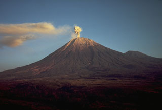
Several hours of observations were made on 7 August by J. Sesiano from the N rim of Jonggring Seloko crater. Gas-and-ash plumes rose hundreds of meters above the crater. Generally mild explosions occurred at intervals of ~15-20 minutes, each resulting in a white plume that barely rose above the crater rim. The explosions originated from the same vent where very slow lava extrusion was feeding a flow moving SE that exhibited red glow and incandescent cracks at night. Based on the movement of unique morphological features of the lava flow, a velocity of tens of meters/day was estimated. Incandescent boulders were thrown from the flow front by violent explosions that occurred an average of 4-5 times/day. Collapses of the lava flow, located on a 35° slope, sent boulders down into the valley accompanied by small pyroclastic flows. Whistles and roaring noises were heard almost continuously, similar to the noises heard at a busy airport: jets taking off, landing, turning off engines, and disappearing into the distance. Thunder-like claps, rhythmic pulses (~1 Hz frequency, for ~10 minutes), and other sounds could also be heard. Seismicity recorded by VSI during 5-14 August indicated that activity was at normal levels, with 40-100 explosion events/day (19:07).
A NOTAM issued from the Bali Flight Information Region (FIR) on 24 October noted volcanic ash from Semeru, but the cloud top and drift direction were unknown.
Geological Summary. Semeru, the highest volcano on Java, and one of its most active, lies at the southern end of a volcanic massif extending north to the Tengger caldera. The steep-sided volcano, also referred to as Mahameru (Great Mountain), rises above coastal plains to the south. Gunung Semeru was constructed south of the overlapping Ajek-ajek and Jambangan calderas. A line of lake-filled maars was constructed along a N-S trend cutting through the summit, and cinder cones and lava domes occupy the eastern and NE flanks. Summit topography is complicated by the shifting of craters from NW to SE. Frequent 19th and 20th century eruptions were dominated by small-to-moderate explosions from the summit crater, with occasional lava flows and larger explosive eruptions accompanied by pyroclastic flows that have reached the lower flanks of the volcano.
Information Contacts: J. Sesiano, Univ de Genéve; BOM Darwin, Australia.

