Report on Semeru (Indonesia) — July 1995

Bulletin of the Global Volcanism Network, vol. 20, no. 7 (July 1995)
Managing Editor: Richard Wunderman.
Semeru (Indonesia) Hazard status raised; mid-July explosion earthquakes, pyroclastic flows
Please cite this report as:
Global Volcanism Program, 1995. Report on Semeru (Indonesia) (Wunderman, R., ed.). Bulletin of the Global Volcanism Network, 20:7. Smithsonian Institution. https://doi.org/10.5479/si.GVP.BGVN199507-263300
Semeru
Indonesia
8.108°S, 112.922°E; summit elev. 3657 m
All times are local (unless otherwise noted)
Increasing seismicity, avalanches, and pyroclastic flows with runout distances over 3 km began in early June 1995 (figure 6). The local government (Lumajang Regency) issued a warning on 21 June, but on 17 July they raised the hazard status and issued a volcano alert.
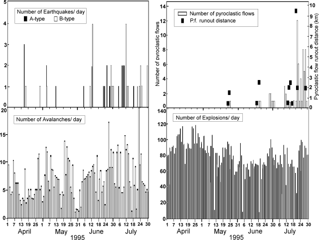 |
Figure 6. Summary of Semeru activity during April-July 1995. Courtesy of VSI. |
On 19 July, explosion earthquakes having maximum amplitudes of 35 mm were recorded. On 20 July at 1140, seismographs recorded continuous earthquakes associated with avalanche-type pyroclastic flows. At 1350 on 20 July, the Semeru Volcano Observatory informed local authorities, the Mt. Semeru Project, and the Ministry of Public Works that lava avalanches and pyroclastic flows were descending SE from Semeru's summit along the Kobokan river (figure 7). A warning was sent to local residents near the Kobokan river in the villages of Sumbersari, Renteng, Deli, and Sukosari. The 20 July pyroclastic flows advanced 9.5 km from the summit along the Sumbersari and Lengkong rivers (figure 7). The pyroclastic flows ceased at 1550 on 20 July; no one was reported injured during this most recent episode, although in a previous episode, in February 1994, lava avalanches and pyroclastic flows killed six people in Sumbersari.
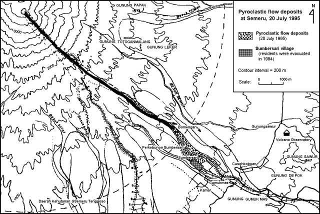 |
Figure 7. Map of Semeru's SE quadrant and 20 July 1995 pyroclastic-flow deposits. Courtesy of VSI. |
On 21 July 1995, three pyroclastic avalanches descended along the Kembar river travelling a distance of 2 km. After 22 July, seismic, avalanche, and pyroclastic flow activity decreased somewhat. Still, on 27 and 28 July, pyroclastic avalanches descended the Kembar and Kobokan rivers, reaching lengths of 1 and 2 km, respectively.
A Semeru eruption was mentioned in an aviation alert on 3 August. The alert, which was based on a report from Qantas Airlines, stated that the estimated eruption time was 1500; the column reached ~4,600 m (roughly 900 m above the summit) and was blown W at 22 km/hour. Convective cloud cover prevented the Synoptic Analysis Branch from searching for the plume.
Geological Summary. Semeru, the highest volcano on Java, and one of its most active, lies at the southern end of a volcanic massif extending north to the Tengger caldera. The steep-sided volcano, also referred to as Mahameru (Great Mountain), rises above coastal plains to the south. Gunung Semeru was constructed south of the overlapping Ajek-ajek and Jambangan calderas. A line of lake-filled maars was constructed along a N-S trend cutting through the summit, and cinder cones and lava domes occupy the eastern and NE flanks. Summit topography is complicated by the shifting of craters from NW to SE. Frequent 19th and 20th century eruptions were dominated by small-to-moderate explosions from the summit crater, with occasional lava flows and larger explosive eruptions accompanied by pyroclastic flows that have reached the lower flanks of the volcano.
Information Contacts: W. Tjetjep, VSI.