Report on Nyiragongo (DR Congo) — January 1996

Bulletin of the Global Volcanism Network, vol. 21, no. 1 (January 1996)
Managing Editor: Richard Wunderman.
Nyiragongo (DR Congo) High levels of seismicity during September 1995
Please cite this report as:
Global Volcanism Program, 1996. Report on Nyiragongo (DR Congo) (Wunderman, R., ed.). Bulletin of the Global Volcanism Network, 21:1. Smithsonian Institution. https://doi.org/10.5479/si.GVP.BGVN199601-223030
Nyiragongo
DR Congo
1.52°S, 29.25°E; summit elev. 3470 m
All times are local (unless otherwise noted)
Volcanic seismicity in the Nyamuragira/Nyiragongo area during 15-30 September was very high (figure 8). This activity was characterized by A-type (high-frequency) and C-type (low-frequency) events. Hypocenters were principally concentrated ESE of the summit of Nyamuragira, NE of Nyiragongo, at depths of 0-20 km. Depths for all of the earthquakes decreased from W to E and from S to N, suggesting a volcanic conduit rising in a generally NE direction towards the surface on the ESE flank of Nyamuragira. The level of volcanic tremor was very low. The low tremor level does not signify an overall reduction in the Nyiragongo lava lake activity, but no fresh lava was apparent in the crater.
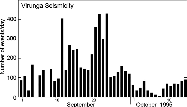 |
Figure 8. Seismicity in the Nyamuragira/Nyiragongo area, 1 September-15 October 1995. Courtesy of the Goma Volcano Observatory. |
Seismic recordings in the first half of October were severely impaired by frequent power disruptions to the observatory and the regular discharge of the batteries. The number of earthquakes decreased significantly compared to September; events were mainly centered at greater depths (5-30 km) SE of Nyiragongo. Problems with the transmitter at the Kunene seismic station prevented acquisition of better data; scientists were unable to visit the station regularly due to a lack of tires for their vehicle.
Seismicity during 15 November-2 December remained high, mainly consisting of A- and C-type earthquakes, and volcanic tremor. The distribution of hypocenters was similar to that observed during September. Each series of earthquakes was followed by up to several hours of tremor. Five seismic stations were operating during this period, four of them (Kibati, Rusayo, Buhimba, and Kunene) telemetered to the Goma observatory, and the fifth (Mt. Goma) connected by cable. However, the transmitter from Kunene was intermittent. Tremor amplitude remained low.
Monitoring of both active Virunga volcanoes is done from a small observatory building located in Goma, ~18 km S of the Nyiragongo crater. Goma is the city where the major encampment of Rwandan civil-war refugees is located. A previous lava lake in the deep summit crater of Nyiragongo, active since 1894, drained suddenly on 10 January 1977, killing about 70 people. Lava lake activity resumed in June 1982, but had ceased by early 1983. The lava lake was again activated after an eruption that began in June 1994 (BGVN 19:06-19:08). Historical eruptions from Nyamuragira (14 km NW of Nyiragongo) have occurred within the summit caldera and from numerous flank fissures and cinder cones. Twentieth century flank lava flows extend >30 km from the summit. Nyamuragira also began erupting in July 1994, producing lava fountaining, lava flows, and ash emission.
Geological Summary. The Nyiragongo stratovolcano contained a lava lake in its deep summit crater that was active for half a century before draining catastrophically through its outer flanks in 1977. The steep slopes contrast to the low profile of its neighboring shield volcano, Nyamuragira. Benches in the steep-walled, 1.2-km-wide summit crater mark levels of former lava lakes, which have been observed since the late-19th century. Two older stratovolcanoes, Baruta and Shaheru, are partially overlapped by Nyiragongo on the north and south. About 100 cones are located primarily along radial fissures south of Shaheru, east of the summit, and along a NE-SW zone extending as far as Lake Kivu. Many cones are buried by voluminous lava flows that extend long distances down the flanks, which is characterized by the eruption of foiditic rocks. The extremely fluid 1977 lava flows caused many fatalities, as did lava flows that inundated portions of the major city of Goma in January 2002.
Information Contacts: Wafula Mifundi and Mahinda Kasereka, Goma Volcano Observatory, Departement de Geophysique, Centre de Recherche en Sciences Naturelles, Lwiro, D.S. Bukavu, Zaire.