Report on Semeru (Indonesia) — January 1996

Bulletin of the Global Volcanism Network, vol. 21, no. 1 (January 1996)
Managing Editor: Richard Wunderman.
Semeru (Indonesia) Explosions, pyroclastic flows, and lava avalanches continue
Please cite this report as:
Global Volcanism Program, 1996. Report on Semeru (Indonesia) (Wunderman, R., ed.). Bulletin of the Global Volcanism Network, 21:1. Smithsonian Institution. https://doi.org/10.5479/si.GVP.BGVN199601-263300
Semeru
Indonesia
8.108°S, 112.922°E; summit elev. 3657 m
All times are local (unless otherwise noted)
Volcanic activity continued until the end of 1995 at a level of intensity comparable to August-October (BGVN 20:09). During November and December, small to moderate explosions and avalanches occurred from the Jonggring Seloko summit crater. The average plume height was 300-500 m. Pyroclastic avalanches descended along the Kembar river to a distance of 500-1,000 m from the summit. The number of lava avalanches increased during November, traveling down the Kembar river up to 300 m from the summit. On 27 December an incandescent lava flow traveled 500 m; during this event volcanic tremor was recorded with a maximum amplitude of 3 mm.
The frequency of volcanic earthquakes (both A- and B- types) during the November- December period ranged from 1 to 10 events/day. Volcanic tremor was recorded on 1, 2, 17, and 18 November; tremor from 15 to 18 December increased to 3-8 events/day (figure 9). Explosion earthquakes were variable (31-136 events/day), with two minima on 5 and 25 December (24 and 19 events/day, respectively) (figure 9).
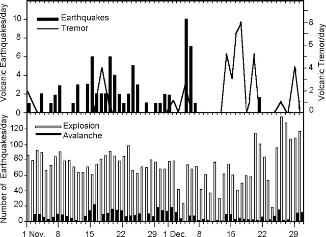 |
Figure 9. Eruptive activity at Semeru as detected by seismograph, November - December 1995: Daily number of tremor and volcanic earthquakes (top), explosions and avalanches (bottom). Courtesy of VSI. |
Typical activity for this volcano was observed by Steve O'Meara on 13 November from the rim of Tengger Caldera. Thick cauliflower-shaped columns of gray ash rose up to 200 m high every 15-20 minutes, and the sky to the SW was spotted with ash clouds from previous eruptions. One event lasted ~5 minutes, generating a dark gray ash cloud that caused ashfall on the S slopes before detaching from the summit. Another eruption cloud spilled over the SW rim and flowed downslope.
Geological Summary. Semeru, the highest volcano on Java, and one of its most active, lies at the southern end of a volcanic massif extending north to the Tengger caldera. The steep-sided volcano, also referred to as Mahameru (Great Mountain), rises above coastal plains to the south. Gunung Semeru was constructed south of the overlapping Ajek-ajek and Jambangan calderas. A line of lake-filled maars was constructed along a N-S trend cutting through the summit, and cinder cones and lava domes occupy the eastern and NE flanks. Summit topography is complicated by the shifting of craters from NW to SE. Frequent 19th and 20th century eruptions were dominated by small-to-moderate explosions from the summit crater, with occasional lava flows and larger explosive eruptions accompanied by pyroclastic flows that have reached the lower flanks of the volcano.
Information Contacts: Wimpy S. Tjetjep (Director), Volcanological Survey of Indonesia (VSI), Jalan Diponegoro 57, Bandung, Indonesia; Steve O'Meara, PO Box 218, Volcano, HI 96785, USA.