Report on Akutan (United States) — March 1996
Bulletin of the Global Volcanism Network, vol. 21, no. 3 (March 1996)
Managing Editor: Richard Wunderman.
Akutan (United States) Seismicity declines with no eruption after two earthquake swarms
Please cite this report as:
Global Volcanism Program, 1996. Report on Akutan (United States) (Wunderman, R., ed.). Bulletin of the Global Volcanism Network, 21:3. Smithsonian Institution. https://doi.org/10.5479/si.GVP.BGVN199603-311320
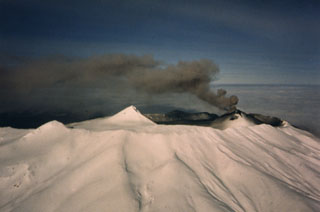
Akutan
United States
54.134°N, 165.986°W; summit elev. 1303 m
All times are local (unless otherwise noted)
Intense seismicity was felt by Akutan residents beginning on the evening of 10 March and through the next day (BGVN 21:02). Students in Akutan (13 km E of the summit; figure 1) carefully counted the frequency and intensity of the earthquakes during the day on 11 March. The resulting information was the first quantitative dataset about the earthquakes and suggested that this was an earthquake swarm rather than a classic mainshock-aftershock sequence. The strongest shocks rattled small objects on tables and caused some cabinet doors to open; ground shaking was continuous. The largest of the earthquakes had a magnitude of about 5.1, and there were several of M 4-5, most of them were probably in the M 2.5 to 4 range. There were no operating seismometers on Akutan Island at the onset of seismic unrest; the nearest seismometer was at Sand Point, ~380 km NE. The intense seismic activity began subsiding at about 1700 on 11 March but remained at a level substantially above normal. Seismicity continued through most of that night with many events strongly felt in Akutan. Seismicity declined on 12 March, and late that day a seismologist from the Alaska Volcano Observatory (AVO) who reached Akutan with a seismometer and a portable recording system determined that the earthquakes were volcano-tectonic.
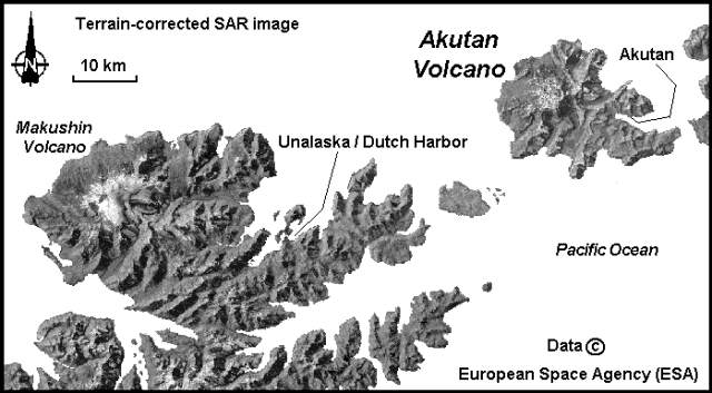 |
Figure 1. Terrain-corrected synthetic aperture radar (SAR) image showing Akutan and Makushin volcanoes in the Aleutian Islands, Alaska. Courtesy of the Alaska SAR Facility; data copyright European Space Agency. |
At about 1700 on 13 March, felt-earthquakes began occurring at a rate of greater than 1/minute, a higher rate than on 11 March. Damage associated with these earthquakes included objects tumbling off shelves, and ground shaking was again continuous. The strongest of these events were felt as far away as Dutch Harbor/Unalaska 50 km SW of Akutan. The number of earthquakes recorded in Akutan was over 800/day during the intense earthquake swarm on 13-14 March. A slight decrease in the rate of activity occurred at about 0500 on 14 March, but felt earthquakes still occurred every 2-3 minutes. There were a few earthquakes with M >= 5, and more between 4 and 5. This swarm began subsiding about 18 hours after onset. Because of the continued high seismicity AVO initiated use of a Level of Concern Color Code system and designated the current level to be Orange on 14 March, indicating an eruption was possible at any time within the next few days. On the night of 14 March, AVO's seismologist in Akutan reported 4-5 felt events.
On 15 March the rate and intensity of recorded earthquakes, although much lower than earlier in the week, remained well above background. At about 1700, a geologist flying into Akutan glimpsed a part of the N flank and summit area through broken clouds, but observed no evidence of eruptive activity. AVO scientists in Akutan felt only a few earthquakes that night. The number of earthquakes recorded on 16 March was much lower than during the swarms of 11 and 13 March. However, the rate and intensity of earthquake activity remained well above background. The weather continued to be poor, hampering visual observations. The number of daily earthquakes remained about the same through 19 March. Scientists in Akutan reported feeling only a few earthquakes each of those nights.
The Level of Concern Color Code was downgraded to Yellow on 20 March based on decreasing seismicity over the previous six days to 60-80 events/day. The Yellow code indicates that the threat of imminent eruption has declined, and the possibility that the volcano will return to quiet over a period of weeks without eruption has increased. An airline passenger reported seeing the snow-filled summit crater, with very slight normal wisps of steam from the central cinder cone, and no evidence of eruptive activity. The level of seismicity remained above background, and several earthquakes each day were felt in Akutan.
By 22 March a total of five seismic stations in four locations had been installed and all data were being sent to the Fairbanks and Anchorage laboratories in real time. Maximum separation of the stations was ~9 km. Four of the stations were located around Akutan Harbor, and the fifth was on the E slopes of the volcano about midway between the village of Akutan and the summit. The seismic array will remain in its present geometry until additional stations can be placed by helicopter this summer. By 24 March all AVO personnel had left, and around-the-clock monitoring using the new seismic stations was being conducted from AVO.
The number of earthquakes continued during 21-25 March at a rate of ~60-80/day, decreased slightly by 27 March to ~40-60/day, and remained at that level through 29 March. As of 5 April seismicity continued to slowly diminish. Earthquakes were distributed widely beneath the E half of the island with a cluster, shallower than 10 km, located ~8-10 km due E of the summit cinder cone and ~5 km W of the village of Akutan. The rate of seismicity during 6-12 April was about half that of the previous week, with ~10-20 earthquakes/day, most too small to be felt by local residents. Seismicity decreased again by half during 13-19 April, to ~5-10 small earthquakes/day.
Geological Summary. Akutan contains a 2-km-wide caldera with a large cinder cone in the NE part of the caldera that has been the source of frequent explosive eruptions and occasional lava effusion that covers the caldera floor. An older, largely buried caldera was formed during the late Pleistocene or early Holocene. Two volcanic centers are located on the NW flank. Lava Peak is of Pleistocene age, and a cinder cone lower on the flank produced a lava flow in 1852 that extended the shoreline of the island and forms Lava Point. The 60-365 m deep younger caldera was formed during a major explosive eruption about 1,600 years ago and contains at least three lakes. A lava flow in 1978 traveled through a narrow breach in the north caldera rim almost to the coast. Fumaroles occur at the base of the caldera cinder cone, and hot springs are located NE of the caldera at the head of Hot Springs Bay valley and along the shores of Hot Springs Bay.
Information Contacts: Alaska Volcano Observatory (AVO), a cooperative program of a) U.S. Geological Survey, 4200 University Drive, Anchorage, AK 99508-4667, USA (URL: http://www.avo.alaska.edu/), b) Geophysical Institute, University of Alaska, PO Box 757320, Fairbanks, AK 99775-7320, USA, and c) Alaska Division of Geological & Geophysical Surveys, 794 University Ave., Suite 200, Fairbanks, AK 99709, USA; Alaska SAR Facility, Geophysical Institute, University of Alaska Fairbanks, Fairbanks, AK 99775 USA.