Report on La Palma (Spain) — June 1996
Bulletin of the Global Volcanism Network, vol. 21, no. 6 (June 1996)
Managing Editor: Richard Wunderman.
La Palma (Spain) No surface deformation detected
Please cite this report as:
Global Volcanism Program, 1996. Report on La Palma (Spain) (Wunderman, R., ed.). Bulletin of the Global Volcanism Network, 21:6. Smithsonian Institution. https://doi.org/10.5479/si.GVP.BGVN199606-383010
La Palma
Spain
28.57°N, 17.83°W; summit elev. 2426 m
All times are local (unless otherwise noted)
A March 1996 EDM survey of the active Cumbre Vieja rift volcano indicated no significant surface deformation since installation of the network in October 1994. The network contains 11 benchmarks (incorporating two Spanish survey triangulation pillars) and was measured using the infrared EDM method. Together with one 3-component seismic station NE of the main rift, the network provides the only current means of monitoring activity on the island.
The deformation network covers the area affected by faulting associated with the July 1949 eruption (figure 1), a zone where W-facing normal faults showed a maximum vertical displacement of ~4 m. The Cumbre Vieja ridge lies between the two 1949 eruptive centers (Duraznero and San Juan). Eyewitness accounts (Bonnelli, 1950) and detailed mapping of the eruptive products showed that during the 1949 eruption, fault displacements also had westward components with downslope movement on the volcano's flanks. La Palma is comparable in form and structure to other Canary Islands that have undergone large-scale slope failure. Steep topography, together with the prospect of a future magma intrusion, cause concern for the long-term stability of the Cumbre Vieja ridge.
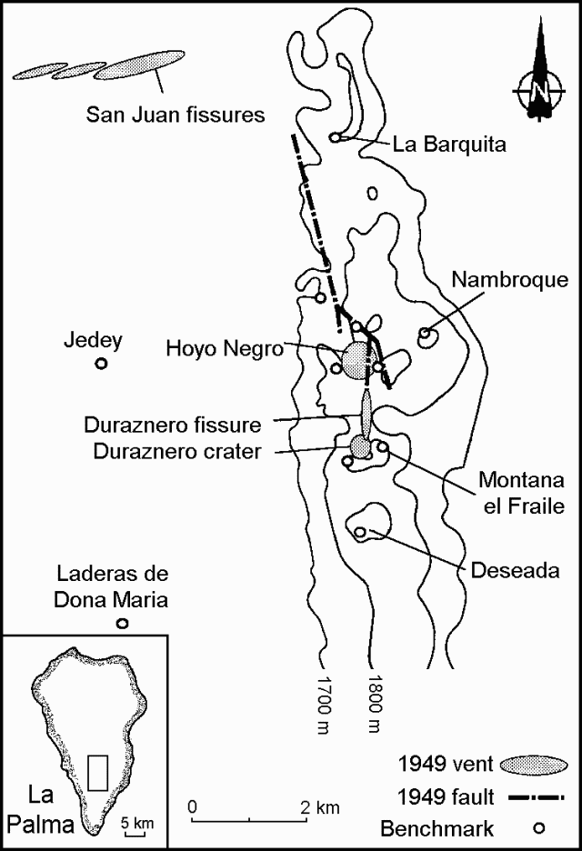 |
Figure 1. Sketch map of the Cumbre Vieja rift volcano showing the distribution of benchmarks, vents, and faults associated with the July 1949 eruption at La Palma. Courtesy of J.L. Moss and W.J. McGuire. |
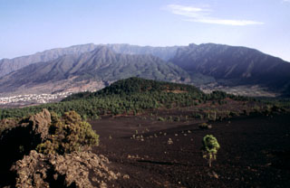
The wedge-shaped island of La Palma contains two large volcanic centers. The northern one is cut by the massive Caldera Taburiente. The southern Cumbre Vieja rift volcano, oriented N-S, has been the site of historical eruptions recorded since the 15th century. An eruption from the S tip of La Palma in 1971 produced the Teneguia cinder cone. Fissure-fed eruptions from vents ~1 km S of the 1677 San Antonio cone produced lava flows that reached the SW coast.
Reference. Bonnelli, R., 1950, Contribucion al estudio de la erupcion del volcan del Nambroque o San Juan (Isla de la Palma), 24 de Junio - Agosto de 1949: Instituto Geografico y Catastral, Madrid, Spain.
Geological Summary. The 47-km-long wedge-shaped island of La Palma, the NW-most of the Canary Islands, is composed of two large volcanic centers. The older northern one is cut by the steep-walled Caldera Taburiente, one of several massive collapse scarps produced by edifice failure to the SW. On the south, the younger Cumbre Vieja volcano is one of the most active in the Canaries. The elongated volcano dates back to about 125,000 years ago and is oriented N-S. Eruptions during the past 7,000 years have formed abundant cinder cones and craters along the axis, producing fissure-fed lava flows that descend steeply to the sea. Eruptions recorded since the 15th century have produced mild explosive activity and lava flows that damaged populated areas. The southern tip of the island is mantled by a broad lava field emplaced during the 1677-1678 eruption. Lava flows also reached the sea in 1585, 1646, 1712, 1949, 1971, and 2021.
Information Contacts: J.L. Moss, W.J. McGuire, and S.J. Day, Center for Volcanic Research, Cheltenham & Gloucester College, Francis Close Hall, Swindon Road, Cheltenham GL50 4AZ, United Kingdom; S.J. Saunders, Brunel University, Department of Geography & Earth Science, Borough Road, Isleworth, Middlesex TW7 5DU, United Kingdom; J-C. Carracedo, Estacion Volcanologica de las Canarias, Tigua Carretera de la Esperanza 3, Apartado de Correos 195, 38206 La Laguna, Tenerife, Canary Islands, Spain.