Report on Colima (Mexico) — February 1999

Bulletin of the Global Volcanism Network, vol. 24, no. 2 (February 1999)
Managing Editor: Richard Wunderman.
Colima (Mexico) Details of the 10 February explosion and fires lit by volcanic bombs
Please cite this report as:
Global Volcanism Program, 1999. Report on Colima (Mexico) (Wunderman, R., ed.). Bulletin of the Global Volcanism Network, 24:2. Smithsonian Institution. https://doi.org/10.5479/si.GVP.BGVN199902-341040
Colima
Mexico
19.514°N, 103.62°W; summit elev. 3850 m
All times are local (unless otherwise noted)
The unusually large 10 February explosion was followed by collateral reports by (a) F. Núñez-Cornú, G. Réyes-Davila, and C. Suárez-Plascenia and (b) John B. Murray. In addition, this summary of the interval 26 February to 16 March benefitted from press releases from the Colima Volcano Observatory. These three sources are discussed in separate sections below.
Geophysical signature of the 10 February explosion. F. Núñez-Cornú, G. Réyes-Davila, and C. Suárez-Plascencia provided the following report.
"On 10 February at 0145 an explosive event occurred at Colima's summit dome; this generated a shock wave that broke windows and opened gates in the small town of Juan Barragan, 8.75 km SE of the summit. The sonic wave was also heard in the towns of Tonila, Quesería, San Marcos, Atenquique, El Fresnito, Ejido de Atenquique, and up to 28 km NE of the volcano at Ciudad Guzman.
"This was the biggest explosion reported for the volcano in the last 80 years; the resulting exhalation emitted both ash and lava blocks (bombs made up of both fresh and altered components). A substantial amount of incandescent tephra fell and started fires on both the volcano's upper slopes and on Nevado de Colima's S slopes; most of the fires were extinguished by snow and rain storms during the subsequent 48 hours.
"As summarized in table 8, a seismic event took place hours before the explosion, at 2231 of 9 February; it was followed by other volcanic and tremor signals at about 0100; some of these precursory events saturated the amplitude response of analog instruments at stations EZV4 (Somma) and EZV7 (Volcancito). Four additional large, post-eruptive seismic events also occurred. These strong events were observed clearly at farther stations EZV3 (Nevado, 5.8 km from the summit), and EZV2 (Cerro Grande, 25 km from the summit)."
Table 8. Noteworthy seismic events around the time of the 10 February 1999 explosion at two Colima seismic stations (EZV3 and EZV2); the earliest reading (on the top line) took place the night before the explosion. See text for station locations. Courtesy of F. Nunez-Cornu, G. Reyes-Davila, and C. Suarez-Plascencia.
| Date | Time | EZV3 coda (sec) | EZV3 amp max (mm) | EZV2 coda (sec) | EZV2 amp max (mm) |
| 10 Feb 1999 | 2231 | 175 | saturated | 120 | 8 |
| 10 Feb 1999 | 0157 | -- | saturated | 300 | saturated |
| 10 Feb 1999 | 0359 | 160 | 16 | 65 | 3 |
| 10 Feb 1999 | 0552 | 110 | saturated | 25 | 2 |
| 10 Feb 1999 | 0730 | 140 | 30 | 70 | 3 |
| 10 Feb 1999 | 1318 | 140 | 34 | 75 | 3 |
"Currently the Jalisco civil defense operates an observational base called Nevado located 900 m NW from the summit of Nevado de Colima.
"Since the end of November 1998, three seismic instruments (MarsLite with LE3d (1 Hz) sensors) were deployed to complement the RESCO network at the volcano. To improve spatial resolution the authors moved one of these instruments to El Playon on 11 February. On the way to El Playon we observed fires on the southern slopes of Nevado out to a maximum distance of 4.5 km from the volcano's summit.
"On the road at a spot 2.9 km NE of the summit and at 3,120 m elevation we found several impact craters. The first one contained an andesite block with dimensions of 0.37 x 0.44 x 0.43 m. Several small impacts occurred nearby. We found another impact pit near the road, 100 m away from the first site but at similar distance and direction from the summit. This pit measured 1.94 x 0.70 m on the surface and had a depth of 0.60 m. It contained a partially buried andesite block (identified as R3) that measured 0.60 x 0.41 x 0.70 m. The block's temperature was 40°C. The pit sat in a spot surrounded by 10- to 15-m-tall trees; their lack of visible damage suggested a near vertical angle of impact, which we estimated as 80-85°.
"At 70 m away from block R3 we found a volcanic bomb that struck the middle of the road. The bomb consisted of hydrothermally altered volcanic breccia (identified as R4, figure 34), which had shattered on the road over an area 1.73 x 1.64 m; the bomb failed to excavate a crater.
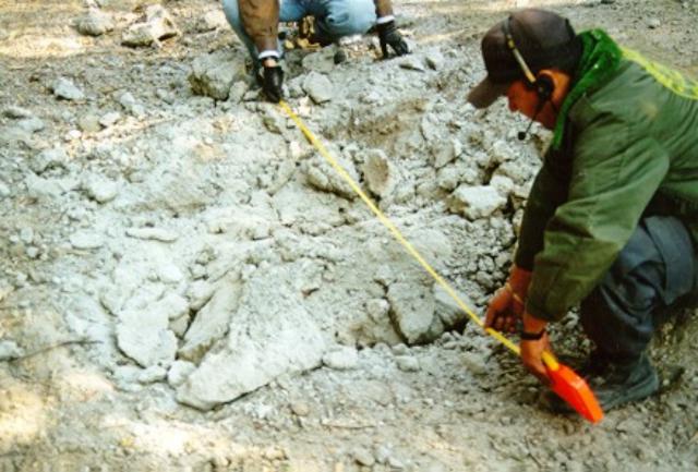 |
Figure 34. Impact crater R4, created by Colima's 10 February 1999 explosion. Courtesy of F. Nunez-Cornu, G. Reyes-Davila, and C. Suarez-Plascencia. |
"In traveling across El Playon we observed dozens of impacts, but elected to stay the minimum time possible in order to reduce exposure to hazards. Most of the bombs seen and sampled consisted of either andesite resembling the new dome or hydrothermally altered andesite, perhaps from the 1987 crater wall. When visiting the same area on 26 February, we found the small and medium impact craters difficult to identify; most of the impacts below trees were covered by newly fallen leaves."
Leveling survey and field examination of the 10 February bombs. On 28 February, John B. Murray, assisted by members of the Colima fire department (Mitchell Ventura, Filiberto de la Mora, and Juan Carlos Martinez) measured two branches of a N-flank leveling traverse last surveyed in January 1997. The first branch, which was 740 m long, left the Playon vehicle track and followed the path up Volcancito passing through stations Porte de Colima (1.3 km from the volcano's summit) and Albergue (1.9 km from the summit). The movement measured since 1997 showed subsidence at stations nearest the volcano totaling 13 mm for the entire section. This was nearly double the subsidence measured during 1995-97, an interval without any lava emission. There was also 13 mm of subsidence seen during 1990-92, an interval which included lava emission (in 1991).
The second branch of the leveling traverse began at Albergue station and ended at Voltaire station, a spot 2.3 km from the summit. Compared to 1997, the Albergue station had subsided just over 8 mm relative to the Voltaire station. Little significant change occurred here during 1995-97 (1 mm rise) and 1990-92 (0.4 mm rise). During a 15-year interval (1982-97) these two stations subsided a total of only 6 mm, and thus looks like a small though significant change in movement. Most of the change (5.6 mm) was measured between two stations 160 m apart at a distance of 2 km from the summit. The possibility of a small error cannot be ruled out, although the movement does follow the same sense throughout this section of the leveling traverse.
The total subsidence between the farthest (2.3 km) and the nearest (1.3 km) station to the summit was 22 mm. This is rather larger than during the 1991 crisis, when the subsidence between the same two stations was 13 mm. Viewing this movement as deflation of a magma chamber (Murray, 1993), this may simply be a reflection of the rather larger output of the volcano in 1998-99 compared to 1991. However, equally tenable is the hypothesis that the movement is due to volcano spreading, or even to Colima's slow slipping down the southern flanks of the larger Nevado volcano, on whose southern slopes Colima is situated. Increases in the rate of subsidence were also observed following the Mexican earthquake of 1985, as well as during the 1991 crisis described above. Although the subsidence during 1997-99 is greater than previously measured, there is nothing in the measurements to suggest that the volcano is building up to a bigger eruption, or to distinguish between the Mogi deflation or downslope slipping models.
The distribution of volcanic bombs from the 10 February explosion was noted at sites along the leveling traverse. Table 9 lists the estimated average distance between impact craters at the various sites where measurements were made. Murray and co-worker identified fragments that varied in size between 10 and 70 cm in diameter, there being no noticeable trend in size between bombs found in the region 1.3 to 2.8 km from the summit. The largest bomb crater found had taken away one third of the road on the north edge of the 1869 lava flow near station Hector, a spot 2.1 km from the summit. This crater was at least 2 m in diameter. However, the numbers of impacts per unit area decreased as distance from the volcano increased.
There is also some evidence of directed blast in table 9, there being distinctly higher concentrations of bombs NNE of the volcano (station Esteban) than at similar distances NE (station C15). Bombs appeared to be of two distinct types: 1) solid, dark, fresh-looking andesitic rocks with high density and no sign of vesiculation, and 2) crumbly, light-colored, altered, vesicular, pumice-like ejecta with low density (guessed at around 1,000 kg/m3) There did not appear to be any predominance of one type or the other with distance from the volcano.
Table 9. Average spacing of N-flank bomb strikes that were found after Colima's 10 February 1999 explosion. Courtesy of John B. Murray.
| Site | Distance from summit | Distance between impacts |
| Volcancito foot | 1.4 km | 3 m |
| Playon (Campsite) | 1.7 km | 5 m |
| Playon (Esteban station) | 2.0 km | 45 m |
| 1869 flow edge (Fire Station) | 2.1 km | 20 m |
| Caldera Wall (C15 station) | 2.1 km | 45 m |
A bomb found near the campsite, 1.75 km from the summit, left evidence of its trajectory as it had smashed a 10 cm branch of a tree just before landing. The bomb itself was of solid andesite, and had fractured into several pieces on landing, but it appeared to have had an original diameter of about 40 cm. It had made an impact crater ~1 m in diameter and 50 cm deep. Using the level as a horizontal marker, three measurements of the angle between the broken branch and the crater bottom gave 44 ± 3° from the horizontal.
Six fire sites were inspected and described; usually these were associated with a bomb, but not always. At first, these fire sites went unnoticed because they chiefly consumed low-growing vegetation, and in no case was a completely burned tree to be found. The view towards the volcano from the Playon was unaffected, as green bushes and trees were seen as usual.
For example, at fire site 3, located 2 km NNE of the summit (N side of road, just past bend near station Esteban) we found an isolated pumice bomb 20 cm across, but without burnt vegetation in contact. However, the bomb ignited grass clumps 2 and 3.5 m away; none of the grass between the bomb and the clumps had been affected.
Most fire sites were close to bombs, usually burning on the side away from the volcano. However, most were not in direct contact with the bomb in question, but centered around dry vegetation, particularly tall grass clumps, succulents, small bushes, and (occasionally) trees. The grass and succulents were not dead, but had fresh green shoots sprouting from the top. Presumably because of the high water content, only the dry, dead leaves at the base of the succulents were burned, but there were large areas where succulents were affected in this way, the adjacent vegetation being quite unaffected. There was often no obvious associated bomb in the vicinity. Similarly with grass clumps, there would be gaps of 2 or 3 m between burned clumps, from which the fire had apparently spread radially for a short distance before going out, with no sign of burning of the dry, low grass cover in between. However, not all bombs in the same area had the same effect. In some cases, the only sign of burning was directly beneath the bomb itself, where the grass was singed black but still fairly intact. Yet in places nearby, the landscape had clearly been very slowly burned over an extensive area 10 to 30 m wide, and in one case discussed below, it was still burning.
Murray goes on to comment: "The odd characteristics of these fire sites suggests the possibility of an abnormal ignition mechanism. It seems that ignition depended in many cases not on the proximity to the source of heat (bombs) but rather on the characteristics of the ignited vegetation. It was as if in certain (sometimes quite extensive) areas those low-growing plants below a certain water content, or containing appropriate oils would ignite, and the rest would not. This implies a very high air temperature close to the ground over areas in some cases tens of meters across. The most obvious source of these high temperatures would seem to be hot gas, usually emanating from bombs but not always so. Where associated with bombs, the isolated fire sites would always be on the side facing away from the summit. In other words, there is evidence that extensive degassing took place from bombs upon impact; and that there might also have been some local associated ground-hugging nuees of a weak and intermittent type."
Explosion on 28 February 1999. Murray also noted that "At 1715 on 28 February, while examining the distant bombs and impact craters 2.8 km NE of the summit on the forest road outside the caldera, we heard a distant, faint rushing sound coming from the summit, resembling a large rockfall or an aircraft. On looking up, a large whitish-grey convective cloud, like a cumulus cloud, could be seen rising from the summit and blowing in our direction. It had clearly started some time previously and was already stretching some distance towards us. A heavy rain of ash began nine minutes later, at 1724, ceasing at ~1731. The ashfall, which was sampled, sounded like large raindrops hitting the leaves in the nearby forest but on spreading out a sheet of paper on the ground, only sand-sized ash particles could be seen accumulating on it. At the end of the shower, there was one particle every centimeter approximately, the largest particle being ~ 2 mm across, and the smallest just under 0.5 mm. From the sound of the particles falling in the trees round about, it sounded as if much larger particles were involved in the shower, but none of these fell on the spread-out paper."
Official press releases. A 26 February update by the Colima Volcano Observatory stated that chemical analysis of Colima's water and ash had indicated insignificant risk to human health. At this time the established security limit was set at 10-10.5 km from the summit. Evacuated settlements included Yerbabuena, Causenta, Atenguillo, El Fresnal, La Cofradía, Juan Barragán, El Agostadero, Los Machos, El Alpizahue, El Saucillo, and El Borbollón. The local populations were advised to avoid a long list of drainages, as well as to hand-carry important documents, and to advise authorities of those requiring help in order to secure transport in case of more extensive evacuations. Meanwhile, during the previous 24 hours the monitored parameters indicated relative quiet, suggesting possible voluntary return to evacuated areas at noon on 2 March if these conditions persisted. The 5 March update noted degassing events during the previous 24 hours, the majority of these around 1400 on 5 March. The 16 March update mentioned the recent occurrence of both degassing and minor ash emissions.
Reference. Murray, J.B., 1993, Ground deformation at Colima Volcano, Mexico, 1982 to 1991: Geofisica Internacional, v. 32, no. 4, p. 659-669.
Geological Summary. The Colima complex is the most prominent volcanic center of the western Mexican Volcanic Belt. It consists of two southward-younging volcanoes, Nevado de Colima (the high point of the complex) on the north and the historically active Volcán de Colima at the south. A group of late-Pleistocene cinder cones is located on the floor of the Colima graben west and east of the complex. Volcán de Colima (also known as Volcán Fuego) is a youthful stratovolcano constructed within a 5-km-wide scarp, breached to the south, that has been the source of large debris avalanches. Major slope failures have occurred repeatedly from both the Nevado and Colima cones, producing thick debris-avalanche deposits on three sides of the complex. Frequent recorded eruptions date back to the 16th century. Occasional major explosive eruptions have destroyed the summit (most recently in 1913) and left a deep, steep-sided crater that was slowly refilled and then overtopped by lava dome growth.
Information Contacts: F. Nunez-Cornu1,4, G. Reyes-Davila2, and C. Suarez-Plascencia3,4; 1) Laboratoria Sismologia, University of Guadelajara, Guadelajara, Mexico; 2) RESCO, University of Colima, Colima, Mexico; 3) Department of Geology, University of Guadelajara, Guadelajara, Mexico; 4) U. Est. Proteccion Civil Jalisco; Colima Volcano Observatory, Universidad de Colima, Av. Gonzalo de Sandoval 444, Colima, Colima 28045, Mexico (URL: https://portal.ucol.mx/cueiv/); J.B. Murray, Department of Earth Sciences, The Open University, Milton Keynes MK7 6AA, England.