Report on Shishaldin (United States) — August 1999
Bulletin of the Global Volcanism Network, vol. 24, no. 8 (August 1999)
Managing Editor: Richard Wunderman.
Shishaldin (United States) Eruption ends after long ash plumes are emitted in late May
Please cite this report as:
Global Volcanism Program, 1999. Report on Shishaldin (United States) (Wunderman, R., ed.). Bulletin of the Global Volcanism Network, 24:8. Smithsonian Institution. https://doi.org/10.5479/si.GVP.BGVN199908-311360
Shishaldin
United States
54.756°N, 163.97°W; summit elev. 2857 m
All times are local (unless otherwise noted)
The eruption that began in mid-April (BGVN 24:03 and 24:04) ended in late May following blasts that sent ash plumes to 6 km altitude. No eruptive activity was observed or reported the week of 15-21 May, but the hazard status remained at Yellow due to persistent low-level seismicity and a summit thermal anomaly. A pilot report at 2311 on 24 May indicated an eruption plume up to 6 km altitude. A narrow ash-rich plume was seen in satellite imagery at 0659 on 25 May, extending about 160 km S from Shishaldin at an estimated altitude of 4.5 km. Following these observations the hazard status was raised to Orange, indicating that the volcano was in eruption. The plume continued to be seen on imagery at 1530, extending 175 km S, with low to moderate levels of seismicity being recorded.
Satellite imagery at 1000 on 26 May indicated that a narrow ash-rich plume continued to be emitted from the volcano, extending ~110 km SE at altitudes of up to 6 km; a pilot report at 1603 on 25 May indicated an ash-rich plume at ~5.5 km altitude. The plume seen on satellite imagery at 1645 extended at least 160 km ESE. Seismicity was at low to moderate levels beneath the volcano. Satellite imagery during the night of 26-27 May showed a continuous narrow ash-rich plume extending ~800 km ESE from the volcano at altitudes of 4.5-6 km until about 0100 on 27 May. After that time the plume became detached from the volcano and had diminished significantly by 0300. A small thermal anomaly in the summit crater was visible in a satellite image at 0908. A ground crew from AVO on the N flank of the volcano reported only white steam from the summit crater during 28 May.
Seismicity remained low through 1 June, and although the top of the volcano was visible no ash plume or thermal anomaly was seen in satellite imagery. The Level of Concern Color Code was therefore downgraded to Yellow. Although low-level seismicity continued, on 18 June AVO lowered the Level of Concern Color Code to Green based on the decline in activity over the previous month.
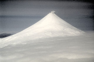
Geological Summary. The symmetrical glacier-covered Shishaldin in the Aleutian Islands is the westernmost of three large stratovolcanoes in the eastern half of Unimak Island. The Aleuts named the volcano Sisquk, meaning "mountain which points the way when I am lost." Constructed atop an older glacially dissected edifice, it is largely basaltic in composition. Remnants of an older edifice are exposed on the W and NE sides at 1,500-1,800 m elevation. There are over two dozen pyroclastic cones on its NW flank, which is covered by massive aa lava flows. Frequent explosive activity, primarily consisting of Strombolian ash eruptions from the small summit crater, but sometimes producing lava flows, has been recorded since the 18th century. A steam plume often rises from the summit crater.
Information Contacts: Alaska Volcano Observatory (AVO), a cooperative program of a) U.S. Geological Survey, 4200 University Drive, Anchorage, AK 99508-4667, USA (URL: http://www.avo.alaska.edu/), b) Geophysical Institute, University of Alaska, PO Box 757320, Fairbanks, AK 99775-7320, USA, and c) Alaska Division of Geological & Geophysical Surveys, 794 University Ave., Suite 200, Fairbanks, AK 99709, USA.