

The Alaska Volcano Observatory (AVO) reported that on 13 December strong winds in the vicinity of Shishaldin dispersed unconsolidated ash up to 2.7 km (9,000 ft) a.s.l. to the SSW. This phenomenon was not the result of recent volcanic activity and occurs during times of strong winds and dry snow-free conditions. The Anchorage Volcanic Ash Advisory Center and AVO reported that plumes of unconsolidated ash were visible in satellite images the next day, rising to the same altitude. Lower-level plumes of unconsolidated ash were also visible the week before, on 6 December, rising to 1.2 km (4,000 ft) a.s.l. The Volcano Alert Level remained at Advisory (the second lowest level on a four-level scale) and the Aviation Color Code remained at Yellow (the second lowest level on a four-color scale).
Sources: US Geological Survey Alaska Volcano Observatory (AVO), Anchorage Volcanic Ash Advisory Center (VAAC)
New eruption with significant Strombolian explosions, ash plumes, and ashfall
Shishaldin is located on the eastern half of Unimak Island, one of the Aleutian Islands. Frequent explosive activity, primarily consisting of Strombolian ash eruptions from the small summit crater, but sometimes producing lava flows, has been recorded since the 18th century. The previous eruption ended in May 2020 and was characterized by intermittent thermal activity, increased seismicity and surface temperatures, ash plumes, and ash deposits (BGVN 45:06). This report covers a new eruption during July through November 2023, which consisted of significant explosions, ash plumes, ashfall, and lava fountaining. Information comes from daily, weekly, and special reports from the Alaska Volcano Observatory (AVO) and various satellite data. AVO monitors the volcano using local seismic and infrasound sensors, satellite data, web cameras, and remote infrasound and lightning networks.
AVO reported that intermittent tremor and low-frequency earthquakes had gradually become more regular and consistent during 10-13 July. Strongly elevated surface temperatures at the summit were identified in satellite images during 10-13 July. On 11 July AVO raised the Aviation Color Code (ACC) to Yellow (the second color on a four-color scale) and Volcano Alert Level (VAL) to Advisory (the second level on a four-level scale) at 1439. Later in the day on 11 July summit crater incandescence was observed in webcam images. Observations of the summit suggested that lava was likely present at the crater, which prompted AVO to raise the ACC to Orange (the second highest color on a four-color scale) and the VAL to Watch (the second highest level on a four-level scale). The US Coast Guard conducted an overflight on 12 July and confirmed that lava was erupting from the summit. That same day, sulfur dioxide emissions were detected in satellite images.
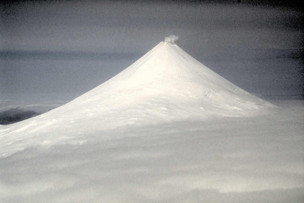
A significant explosion began at 0109 on 14 July that produced an ash plume that rose to 9-12 km altitude and drifted S over the Pacific Ocean (figure 43). Webcam images and photos taken around 0700 from a ship SW off Unimak Island showed small lahar deposits, which were the result of the interaction of hot pyroclastic material and snow and ice on the flanks. There was also ashfall on the SW and N flanks. A smaller explosion at 0710 generated an ash plume that rose to 4.5 km altitude. Webcam images and pilot reports showed continued low-level ash emissions during the morning, rising to less than 4.6 km altitude; those emissions included a small ash plume near the summit around 1030 resulting from a small explosion.
 |
Figure 43. Photo of a strong ash plume that rose to 9-12 km altitude on the morning of 14 July 2023. Lahar deposits were visible on the SW flank (white arrows). Photo has been color corrected. Courtesy of Christopher Waythomas, AVO. |
Seismic tremor amplitude began increasing at around 1700 on 15 July; strongly elevated surface temperatures were also reported. An ash plume rose to 4.6 km altitude and drifted SSE at 2100, based on a satellite image. A continuous ash plume during 2150 through 2330 rose to 5 km altitude and extended 125 km S. At 2357 AVO raised the ACC to Red (the highest color on a four-color scale) and the VAL to Warning (the highest level on a four-level scale), noting that seismicity remained elevated for more than six hours and explosion signals were frequently detected by regional infrasound (pressure sensor) networks. Explosions generated an ash plume that rose to 4.9 km altitude and drifted as far as 500 km SE. Activity throughout the night declined and by 0735 the ACC was lowered to Orange and the VAL to Watch. High-resolution satellite images taken on 16 July showed pyroclastic deposits extending as far as 3 km from the vent; these deposits generated lahars that extended further down the drainages on the flanks. Ash deposits were mainly observed on the SSE flank and extended to the shore of Unimak Island. During 16-17 July lava continued to erupt at the summit, which caused strongly elevated surface temperatures that were visible in satellite imagery.
Lava effusion increased at 0100 on 18 July, as noted in elevated surface temperatures identified in satellite data, increasing seismic tremor, and activity detected on regional infrasound arrays. A significant ash plume at 0700 rose to 7 km altitude and continued until 0830, eventually reaching 9.1 km altitude and drifting SSE (figure 44). As a result, the ACC was raised to Red and the VAL to Warning. By 0930 the main plume detached, but residual low-level ash emissions continued for several hours, remaining below 3 km altitude and drifting S. The eruption gradually declined and by 1208 the ACC was lowered to Orange and the VAL was lowered to Watch. High-resolution satellite images showed ash deposits on the SW flank and pyroclastic deposits on the N, E, and S flanks, extending as far as 3 km from the vent; lahars triggered by the eruption extended farther down the flanks (figure 45). Lava continued to erupt from the summit crater on 19 July.
 |
Figure 44. Photo of an ash-rich plume rising above Shishaldin to 9.1 km altitude on 18 July 2023 that drifted SE. View is from the N of the volcano and Isanotski volcano is visible on the left-hand side of the image. Photo has been color corrected. Courtesy of Chris Barnes, AVO. |
 |
Figure 45. Near-infrared false-color satellite image of Shishaldin taken on 18 July 2023 showing ash deposits on the N, E, and S flanks extending as far as 3 km from the vent due to recent eruption events. Courtesy of Matthew Loewen, AVO. |
Elevated surface temperatures were detected in satellite images during 19-25 July, despite occasional weather cloud cover, which was consistent with increased lava effusion. During 22-23 July satellite observations acquired after the eruption from 18 July showed pyroclastic flow and lahar deposits extending as far as 3 km down the N, NW, and NE flanks and as far as 1.5 km down the S and SE flanks. Ash deposits covered the SW and NE flanks. No lava flows were observed outside the crater. On 22 July a sulfur dioxide plume was detected in satellite data midday that had an estimated mass of 10 kt. In a special notice issued at 1653 on 22 July AVO noted that eruptive activity had intensified over the previous six hours, which was characterized by an hours-long steady increase in seismic tremor, intermittent infrasound signals consistent with small explosions, and an increase in surface temperatures that were visible in satellite data. Pilots first reported low-level ash plumes at around 1900. At 2320 an ash plume had risen to 9 km altitude based on additional pilot reports and satellite images. The ACC was increased to Red and the VAL to Warning at 2343. Satellite images indicated growth of a significantly higher ash plume that rose to 11 km altitude continued until 0030 and drifted NE. During the early morning hours of 23 July ash plumes had declined to 4.6 k altitude. Seismic tremor peaked at 0030 on 23 July and began to rapidly decline at 0109; active ash emissions were no longer visible in satellite data by 0130. The ACC was lowered to Orange and the VAL to Watch at 0418; bursts of increased seismicity were recorded throughout the morning, but seismicity generally remained at low levels. Elevated surface temperatures were visible in satellite data until about 0600. On 24 July pilots reported seeing vigorous gas-and-steam plumes rising to about 3 km altitude; the plumes may have contained minor amounts of ash.
During 24-25 July low level seismicity and volcanic tremor were detected at low levels following the previous explosion on 23 July. Strongly elevated surface temperatures were observed at the summit crater in satellite data. Around 2200 on 25 July seismicity began to increase, followed by infrasound signals of explosions after 0200 on 26 July. An ash plume rose to 3 km altitude at 0500 and drifted ENE, along with an associated sulfur dioxide plume that drifted NE and had an estimated mass of 22 kt. Diffuse ash emissions were visible in satellite data and rose to 6.1-7.6 km altitude and extended 125 km from the volcano starting around 1130. These ash events were preceded by about seven hours of seismic tremor, infrasound detections of explosions, and five hours of increased surface temperatures visible in satellite data. Activity began to decline around 1327, which included low-frequency earthquakes and decreased volcanic tremor, and infrasound data no longer detected significant explosions. Surface temperatures remained elevated through the end of the month.
Seismicity, volcanic tremor, and ash emissions remained at low levels during early August. Satellite images on 1 August showed that some slumping had occurred on the E crater wall due to the recent explosive activity. Elevated surface temperatures continued, which was consistent with cooling lava. On 2 August small explosive events were detected, consistent with low-level Strombolian activity. Some episodes of volcanic tremor were reported, which reflected low-level ash emissions. Those ash emissions rose to less than 3 km altitude and drifted as far as 92.6 km N. Pilots that were located N of the volcano observed an ash plume that rose to 2.7 km altitude. Seismicity began to increase in intensity around 0900 on 3 August. Seismicity continued to increase throughout the day and through the night with strongly elevated surface temperatures, which suggested that lava was active at the surface.
An ash cloud that rose to 7.6-7.9 km altitude and drifted 60-75 km NE was visible in a satellite image at 0520 on 4 August. Pilots saw and reported the plume at 0836 (figure 46). By 0900 the plume had risen to 9.1 km altitude and extended over 100 km NE. AVO raised the ACC to Red and the VAL to Warning as a result. Seismic tremor levels peaked at 1400 and then sharply declined at 1500 to slightly elevated levels; the plume was sustained during the period of high tremor and drifted N and NE. The ACC was lowered to Orange and the VAL to Watch at 2055. During 5-14 August seismicity remained low and surface temperatures were elevated based on satellite data due to cooling lava. On 9 August a small lava flow was observed that extended from the crater rim to the upper NE flank. It had advanced to 55 m in length and appeared in satellite imagery on 11 August. Occasional gas-and-steam plumes were noted in webcam images. At 1827 AVO noted that seismic tremor had steadily increased during the afternoon and erupting lava was visible at the summit in satellite images.
 |
Figure 46. Photo showing an ash plume rising above Shishaldin during the morning of 4 August 2023 taken by a passing aircraft. The view is from the N showing a higher gas-rich plume and a lower gray ash-rich plume and dark tephra deposits on the volcano’s flank. Photo has been color corrected. Courtesy of Chris Barnes, AVO. |
Strong explosion signals were detected at 0200 on 15 August. An ash cloud that was visible in satellite data extended 100 km NE and may have risen as high as 11 km altitude around 0240. By 0335 satellite images showed the ash cloud rising to 7.6 km altitude and drifting NE. Significant seismicity and explosions were detected by the local AVO seismic and infrasound networks, and volcanic lightning was detected by the World Wide Lightning Location Network (WWLLN). A sulfur dioxide plume associated with the eruption drifted over the S Bering Sea and parts of Alaska and western Canada. Seismicity was significantly elevated during the eruption but had declined by 1322. A pilot reported that ash emissions continued, rising as high as 4.9 km altitude. Elevated surface temperatures detected in satellite data were caused by hot, eruptive material (pyroclastic debris and lava) that accumulated around the summit. Eruptive activity declined by 16 August and the associated sulfur dioxide plume had mostly dissipated; remnants continued to be identified in satellite images at least through 18 August. Surface temperatures remained elevated based on satellite images, indicating hot material on the upper parts of the volcano. Small explosions were detected in infrasound data on the morning of 19 August and were consistent with pilot reports of small, short-lived ash plumes that rose to about 4.3 km altitude. Low-level explosive activity was reported during 20-24 August, according to seismic and infrasound data, and weather clouds sometimes prevented views. Elevated surface temperatures were observed in satellite images, which indicated continued hot material on the upper parts of the volcano.
Seismic tremor began to increase at around 0300 on 25 August and was followed by elevated surface temperatures identified in satellite images, consistent with erupting lava. Small explosions were recorded in infrasound data. The ACC was raised to Red and the VAL to Warning at 1204 after a pilot reported an ash plume that rose to 9.1 km altitude. Seismicity peaked at 1630 and began to rapidly decline at around 1730. Ash plumes rose as high as 10 km altitude and drifted as far as 400 km NE. By 2020 the ash plumes had declined to 6.4 km altitude and continued to drift NE. Ash emissions were visible in satellite data until 0000 on 26 August and seismicity was at low levels. AVO lowered the ACC to Orange and the VAL to Watch at 0030. Minor explosive activity within the summit crater was detected during 26-28 August and strongly elevated surface temperatures were still visible in satellite imagery through the rest of the month. An AVO field crew working on Unimak Island observed a mass flow that descended the upper flanks beginning around 1720 on 27 August. The flow produced a short-lived ash cloud that rose to 4.5 km altitude and rapidly dissipated. The mass flow was likely caused by the collapse of spatter that accumulated on the summit crater rim.
Similar variable explosive activity was reported in September, although weather observations sometimes prevented observations. A moderate resolution satellite image from the afternoon of 1 September showed gas-and-steam emissions filling the summit crater and obscuring views of the vent. In addition, hot deposits from the previous 25-26 August explosive event were visible on the NE flank near the summit, based on a 1 September satellite image. On 2 and 4 September seismic and infrasound data showed signals of small, repetitive explosions. Variable gas-and-steam emissions from the summit were visible but there was no evidence of ash. Possible summit crater incandescence was visible in nighttime webcam images during 3-4 September.
Seismicity began to gradually increase at around 0300 on 5 September and activity escalated at around 0830. A pilot reported an ash plume that rose to 7.6 km altitude at 0842 and continued to rise as high as possibly 9.7 km altitude and drifted SSE based on satellite images (figure 47). The ACC was raised to Red and the VAL to Warning at 0900. In addition to strong tremor and sustained explosions, the eruption produced volcanic lightning that was detected by the WWLLN. Around 1100 seismicity decreased and satellite data confirmed that the altitude of the ash emissions had declined to 7.6 km altitude. By 1200 the lower-altitude portion of the ash plume had drifted 125 km E. Significant ash emissions ended by 1330 based on webcam images. The ACC was lowered to Orange and the VAL to Watch at 1440. Satellite images showed extensive pyroclastic debris flows on most of the flanks that extended 1.2-3.3 km from the crater rim.
 |
Figure 47. Webcam image taken from the S of Shishaldin showing a vertical ash plume on 5 September 2023. Courtesy of AVO. |
During 6-13 September elevated surface temperatures continued to be observed in satellite data, seismicity remained elevated with weak but steady tremor, and small, low-frequency earthquakes and small explosions were reported, except on 12 September. On 6 September a low-level ash plume rose to 1.5-1.8 km altitude and drifted SSE. Occasional small and diffuse gas-and-steam emissions at the summit were visible in webcam images. Around 1800 on 13 September seismic tremor amplitudes began to increase, and small explosions were detected in seismic and infrasound data. Incandescent lava at the summit was seen in a webcam image taken at 0134 on 14 September during a period of elevated tremor. No ash emissions were reported during the period of elevated seismicity. Lava fountaining began around 0200, based on webcam images. Satellite-based radar observations showed that the lava fountaining activity led to the growth of a cone in the summit crater, which refilled most of the crater. By 0730 seismicity significantly declined and remained at low levels.
Seismic tremor began to increase around 0900 on 15 September and rapidly intensified. An explosive eruption began at around 1710, which prompted AVO to raise the ACC to Red and the VAL to Warning. Within about 30 minutes ash plumes drifted E below a weather cloud at 8.2 km altitude. The National Weather Service estimated that an ash-rich plume rose as high as 12.8 km altitude and produced volcanic lightning. The upper part of the ash plume detached from the vent around 1830 and drifted E, and was observed over the Gulf of Alaska. Around the same time, seismicity dramatically decreased. Trace ashfall was reported in the community of False Pass (38 km ENE) between 1800-2030 and also in King Cove and nearby marine waters. Activity declined at around 1830 although seismicity remained elevated, ash emissions, and ashfall continued until 2100. Lightning was again detected beginning around 1930, which suggested that ash emissions continued. Ongoing explosions were detected in infrasound data, at a lower level than during the most energetic phase of this event. Lightning was last detected at 2048. By 2124 the intensity of the eruption had decreased, and ash emissions were likely rising to less than 6.7 km altitude. Seismicity returned to pre-eruption levels. On 16 September the ACC was lowered to Orange and the VAL to Watch at 1244; the sulfur dioxide plume that was emitted from the previous eruption event was still visible over the northern Pacific Ocean. Elevated surface temperatures, gas-and-steam emissions from the vent, and new, small lahars were reported on the upper flanks based on satellite and webcam images. Minor deposits were reported on the flanks which were likely the result of collapse of previously accumulated lava near the summit crater.
Elevated seismicity with tremor, small earthquakes, and elevated surface temperatures were detected during 17-23 September. Minor gas-and-steam emissions were visible in webcam images. On 20 September small volcanic debris flows were reported on the upper flanks. On 21 September a small ash deposit was observed on the upper flanks extending to the NE based on webcam images. Seismic tremor increased significantly during 22-23 September. Regional infrasound sensors suggested that low-level eruptive activity was occurring within the summit crater by around 1800 on 23 September. Even though seismicity was at high levels, strongly elevated surface temperatures indicating lava at the surface were absent and no ash emissions were detected; weather clouds at 0.6-4.6 km altitude obscured views. At 0025 on 24 September AVO noted that seismicity continued at high levels and nearly continuous small infrasound signals began, likely from low-level eruptive activity. Strongly elevated surface temperatures were identified in satellite images by 0900 and persisted throughout the day; the higher temperatures along with infrasound and seismic data were consistent with lava erupting at the summit. Around 1700 similarly elevated surface temperatures were detected from the summit in satellite data, which suggested that more vigorous lava fountaining had started. Starting around 1800 low-level ash emissions rose to altitudes less than 4.6 km altitude and quickly dissipated.
Beginning at midnight on 25 September, a series of seismic signals consistent with volcanic flows were recorded on the N side of the volcano. A change in seismicity and infrasound signals occurred around 0535 and at 0540 a significant ash cloud formed and quickly reached 14 km altitude and drifted E along the Alaska Peninsula. The cloud generated at least 150 lightning strokes with thunder that could be heard by people in False Pass. Seismicity rapidly declined to near background levels around 0600. AVO increased the ACC to Red and the VAL to Warning at 0602. The ash cloud detached from the volcano at around 0700, rose to 11.6 km altitude, and drifted ESE. Trace to minor amounts of ashfall were reported by the communities of False Pass, King Cove, Cold Bay, and Sand Point around 0700. Ash emissions continued at lower altitudes of 6-7.6 km altitude at 0820. Small explosions at the vent area continued to be detected in infrasound data and likely represented low-level eruptive activity near the vent. Due to the significant decrease in seismicity and ash emissions the ACC was lowered to Orange and the VAL to Watch at 1234. Radar data showed significant collapses of the crater that occurred on 25 September. Satellite data also showed significant hot, degassing pyroclastic and lahar deposits on all flanks, including more extensive flows on the ENE and WSW sections below two new collapse scarps. Following the significant activity during 24-25 September, only low-level activity was observed. Seismicity decreased notably near the end of the strong activity on 25 September and continued to decrease through the end of the month, though tremor and small earthquakes were still reported. No explosive activity was detected in infrasound data through 2 October. Gas-and-steam emissions rose to 3.7 km altitude, as reported by pilots and seen in satellite images. Satellite data from 26 September showed that significant collapses had occurred at the summit crater and hot, steaming deposits from pyroclastic flows and lahars were present on all the flanks, particularly to the ENE and WSW. A small ash cloud was visible in webcam images on 27 September, likely from a collapse at the summit cone. High elevated surface temperatures were observed in satellite imagery during 27-28 September, which were likely the result of hot deposits on the flanks erupted on 25 September. Minor steaming at the summit crater and from an area on the upper flanks was visible in webcam images on 28 September.
During October, explosion events continued between periods of low activity. Seismicity significantly increased starting at around 2100 on 2 October; around the same time satellite images showed an increase in surface temperatures consistent with lava fountaining. Small, hot avalanches of rock and lava descended an unspecified flank. In addition, a distinct increase in infrasound, seismicity, and lightning detections was followed by an ash plume that rose to 12.2 km altitude and drifted S and E at 0520 on 3 October, based on satellite images. Nighttime webcam images showed incandescence due to lava fountaining at the summit and pyroclastic flows descending the NE flank. AVO reported that a notable explosive eruption started at 0547 and lasted until 0900 on 3 October, which prompted a rise in the ACC to Red and the VAL to Warning. Subsequent ash plumes rose to 6-7.6 km altitude by 0931. At 1036 the ACC was lowered back to Orange and the VAL to Watch since both seismic and infrasound data quieted substantially and were slightly above background levels. Gas-and-steam emissions were observed at the summit, based on webcam images. Trace amounts of ashfall were observed in Cold Bay. Resuspended ash was present at several kilometers altitude near the volcano. During the afternoon, low-level ash plumes were visible at the flanks, which appeared to be largely generated by rock avalanches off the summit crater following the explosive activity. These ash plumes rose to 3 km altitude and drifted W. Trace amounts of ashfall were reported by observers in Cold Bay and Unalaska and flights to these communities were disrupted by the ash cloud. Satellite images taken after the eruption showed evidence of pyroclastic flows and lahar deposits in drainages 2 km down the SW flank and about 3.2 km down the NE flank, and continued erosion of the crater rim. Small explosion craters at the end of the pyroclastic flows on the NE flank were noted for the first time, which may have resulted from gas-and-steam explosions when hot deposits interact with underlying ice.
During 4 October seismicity, including frequent small earthquakes, remained elevated, but was gradually declining. Ash plumes were produced for over eight hours until around 1400 that rose to below 3.7 km altitude. These ash plumes were primarily generated off the sides of the volcano where hot rock avalanches from the crater rim had entered drainages to the SW and NE. Two explosion craters were observed at the base of the NE deposits about 3.2 km from the crater rim. Webcam images showed the explosion craters were a source of persistent ash emissions; occasional collapse events also generated ash. Seismicity remained elevated with sulfur dioxide emissions that had a daily average of more than 1,000 tons per day, and frequent small earthquakes through the end of the month. Frequent elevated surface temperatures were identified in satellite images and gas-and-steam plumes were observed in webcam images, although weather conditions occasionally prevented clear views of the summit. Emissions were robust during 14-16 October and were likely generated by the interaction of hot material and snow and ice. During the afternoon of 21 October a strong gas-and-steam plume rose to 3-4.6 km altitude and extended 40 km WSW, based on satellite images and reports from pilots. On 31 October the ACC was lowered to Yellow and the VAL was lowered to Advisory.
Activity in November was characterized by elevated seismicity with ongoing seismic tremor and small, low-frequency earthquakes, elevated surface temperatures, and gas-and-steam emissions. There was an increase in seismic and infrasound tremor amplitudes starting at 1940 on 2 November. As a result, the ACC was again raised to Orange and the VAL was increased to Watch, although ash was not identified in satellite data. An ash cloud rose to 6.1 km altitude and drifted W according to satellite data at 2000. By 0831 on 3 November ash emissions were no longer visible in satellite images. On 6 and 9 November air pressure sensors detected signals consistent with small explosions. Small explosions were detected in infrasound data consistent with weak Strombolian activity on 19 and 21 November. Seismicity started to decrease on 21 November. On 25 November gas-and-steam emissions were emitted from the vent as well as from a scarp on the NE side of the volcano near the summit. A gas-and-steam plume extended about 50 km SSE and was observed in satellite and webcam images on 26 November. On 28 November small explosions were observed in seismic and local infrasound data and gas-and-steam emissions were visible from the summit and from the upper NE collapse scarp based on webcam images. Possible small explosions were observed in infrasound data on 30 November. Weakly elevated surface temperatures and a persistent gas-and-steam plume from the summit and collapse scarps on the upper flanks. A passing aircraft reported the gas-and-steam plume rose to 3-3.4 km altitude on 30 November, but no significant ash emissions were detected.
Satellite data. MODIS thermal anomaly data provided through MIROVA (Middle InfraRed Observation of Volcanic Activity) showed a strong pulse of thermal activity beginning in July 2023 that continued through November 2023 (figure 48). This strong activity was due to Strombolian explosions and lava fountaining events at the summit crater. According to data from MODVOLC thermal alerts, a total of 101 hotspots were detected near the summit crater in July (11-14, 16-19, 23-24 and 26), August (4, 25-26, and 29), September (5, 12, and 17), and October (3, 4, and 8). Infrared satellite data showed large lava flows descending primarily the northern and SE flanks during the reporting period (figure 49). Sulfur dioxide plumes often exceeded two Dobson Units (DUs) and drifted in different directions throughout the reporting period, based on satellite data from the TROPOMI instrument on the Sentinel-5P satellite (figure 50).
 |
Figure 48. Graph of Landsat 8 and 9 OLI thermal data from 1 June 2024 showing a strong surge in thermal activity during July through November 2023. During mid-October, the intensity of the hotspots gradually declined. Courtesy of MIROVA. |
 |
Figure 49. Infrared (bands B12, B11, B4) satellite images show several strong lava flows (bright yellow-orange) affecting the northern and SE flanks of Shishaldin on 18 July 2023 (top left), 4 June 2023 (top right), 26 September 2023 (bottom left), and 3 October 2023 (bottom right). Courtesy of Copernicus Browser. |
 |
Figure 50. Strong sulfur dioxide plumes were detected at Shishaldin and drifted in different directions on 15 August 2023 (top left), 5 September 2023 (top right), 25 September 2023 (bottom left), and 6 October 2023 (bottom right). Courtesy of NASA Global Sulfur Dioxide Monitoring Page. |
Information Contacts: Alaska Volcano Observatory (AVO), a cooperative program of a) U.S. Geological Survey, 4200 University Drive, Anchorage, AK 99508-4667 USA (URL: https://avo.alaska.edu/), b) Geophysical Institute, University of Alaska, PO Box 757320, Fairbanks, AK 99775-7320, USA, and c) Alaska Division of Geological & Geophysical Surveys, 794 University Ave., Suite 200, Fairbanks, AK 99709, USA (URL: http://dggs.alaska.gov/); MIROVA (Middle InfraRed Observation of Volcanic Activity), a collaborative project between the Universities of Turin and Florence (Italy) supported by the Centre for Volcanic Risk of the Italian Civil Protection Department (URL: http://www.mirovaweb.it/); Hawai'i Institute of Geophysics and Planetology (HIGP) - MODVOLC Thermal Alerts System, School of Ocean and Earth Science and Technology (SOEST), Univ. of Hawai'i, 2525 Correa Road, Honolulu, HI 96822, USA (URL: http://modis.higp.hawaii.edu/); NASA Global Sulfur Dioxide Monitoring Page, Atmospheric Chemistry and Dynamics Laboratory, NASA Goddard Space Flight Center (NASA/GSFC), 8800 Greenbelt Road, Goddard, Maryland, USA (URL: https://so2.gsfc.nasa.gov/); Copernicus Browser, Copernicus Data Space Ecosystem, European Space Agency (URL: https://dataspace.copernicus.eu/browser/).
2025: August
| December
2024: February
| August
2023: July
| August
| September
| October
| November
| December
2021: January
| March
| October
2020: January
| February
| March
| April
| June
2019: July
| August
| September
| October
| November
| December
2018: February
2017: December
2016: March
2015: January
| February
| March
| April
| May
| June
| July
| August
| September
| October
| November
2014: January
| February
| March
| April
| May
| June
| July
| August
| September
| October
| November
| December
2009: January
| February
| July
| October
2008: February
| December
2004: April
| May
| June
| July
| September
| October
2002: May
The Alaska Volcano Observatory (AVO) reported that on 13 December strong winds in the vicinity of Shishaldin dispersed unconsolidated ash up to 2.7 km (9,000 ft) a.s.l. to the SSW. This phenomenon was not the result of recent volcanic activity and occurs during times of strong winds and dry snow-free conditions. The Anchorage Volcanic Ash Advisory Center and AVO reported that plumes of unconsolidated ash were visible in satellite images the next day, rising to the same altitude. Lower-level plumes of unconsolidated ash were also visible the week before, on 6 December, rising to 1.2 km (4,000 ft) a.s.l. The Volcano Alert Level remained at Advisory (the second lowest level on a four-level scale) and the Aviation Color Code remained at Yellow (the second lowest level on a four-color scale).
Sources: US Geological Survey Alaska Volcano Observatory (AVO); Anchorage Volcanic Ash Advisory Center (VAAC)
The Alaska Volcano Observatory (AVO) reported that signs of volcanic unrest at Shishaldin had been gradually increasing during the previous month. Specifically, sulfur dioxide emissions had increased, observers noted a more vigorous steam plume rising from the summit crater, and seismic and infrasound data showed moderate increases in both the number and amplitude of events. At 1148 on 25 August the Volcano Alert Level was raised to Advisory (the second lowest level on a four-level scale) and the Aviation Color Code was raised Yellow (the second lowest color on a four-color scale).
Source: US Geological Survey Alaska Volcano Observatory (AVO)
AVO reported that volcanic unrest at Shishaldin declined over the past several months. Slightly elevated seismicity, small infrasound signals, and weak gas emissions persisted, but there were no signs of explosivity nor the presence of lava in the summit crater. AVO noted that the activity was at background levels, and at 0900 on 30 August the Volcano Alert Level was lowered to Normal (the lowest level on a four-level scale) and the Aviation Color Code was lowered to Green (the lowest color on a four-color scale).
Source: US Geological Survey Alaska Volcano Observatory (AVO)
AVO reported that low-level unrest at Shishaldin continued during 13-20 February. Occasional small volcanic earthquakes were recorded daily by the seismic network. Robust steaming was observed in satellite and webcam images and reported by local pilots on 13 February, and minor steaming was visible in satellite and webcam images during 14-15 February. AVO noted that steam emissions were not uncommon at Shishaldin. At 1126 on 17 February AVO lowered the Volcano Alert Level to Advisory (the second lowest level on a four-level scale) and the Aviation Color Code to Yellow (the second lowest color on a four-color scale) noting that there were no signs of eruptive activity.
Source: US Geological Survey Alaska Volcano Observatory (AVO)
AVO raised the Volcano Alert Level for Shishaldin to Watch (the third level on a four-level scale) and the Aviation Color Code to Orange (the third color on a four-color scale) at 1246 on 11 February due to a slight increase in volcanic activity. Minor ash emissions were observed in a webcam image timestamped at 0925 on 11 February. The low-level ash cloud extended from the summit crater and draped over the N flank. AVO posited that since seismic signals typically associated with surficial mass flows were recorded at the same time as the ash emission event, a collapse event of previously deposited material on the upper area of the cone could have occurred. After the minor ash episode occurred, weather clouds obscured views of the summit and there was no evidence of ash in satellite images.
Source: US Geological Survey Alaska Volcano Observatory (AVO)
On 2 January AVO lowered the Volcano Alert Level for Shishaldin to Advisory (the second level on a four-level scale) and the Aviation Color Code to Yellow (the second color on a four-color scale), noting that activity had declined over the past two months since the last significant explosive event on 3 November. Small explosions continued to be periodically detected in infrasound data, though no new deposits inside or outside the crater had recently been observed. Surface temperatures detected in satellite data were low, suggesting that no fresh lava was present in the summit crater. Steaming from the crater continued to be observed in webcam images.
Source: US Geological Survey Alaska Volcano Observatory (AVO)
AVO reported that unrest continued at Shishaldin during 20-26 December. Seismicity was slightly elevated and consisted of small low-frequency earthquakes and tremor. Minor steaming was visible in a webcam image during 20-21 December. The Volcano Alert Level remained at Watch (the third level on a four-level scale) and the Aviation Color Code remained at Orange (the third color on a four-color scale).
Source: US Geological Survey Alaska Volcano Observatory (AVO)
AVO reported that unrest continued at Shishaldin during 12-19 December. Seismicity remained low and was characterized by small low-frequency earthquakes recorded daily and tremor recorded during 15-19 December. Barely elevated surface temperatures identified in satellite images during 13-14 December were likely associated with cooling deposits on the upper flanks. Minor steaming at the summit was visible in webcam images on 15 December. Infrasound signals indicating weak explosions were detected during 17-18 December but did not produce ash emissions; only minor steaming at the summit was visible in clear webcam images. The Volcano Alert Level remained at Watch (the third level on a four-level scale) and the Aviation Color Code remained at Orange (the third color on a four-color scale).
Source: US Geological Survey Alaska Volcano Observatory (AVO)
AVO reported that unrest continued at Shishaldin during 6-12 December. Seismicity remained low with small, frequent, low-frequency earthquakes recorded daily. Weak explosions were detected in infrasound data during 6 and 8-9 December, though none produced ash. Elevated surface temperatures were identified in a clear satellite image during 8-9 December, and minor steaming at the summit was observed in webcam images during 8-10 December. Cloudy weather sometimes prevented views of the summit. The Volcano Alert Level remained at Watch (the third level on a four-level scale) and the Aviation Color Code remained at Orange (the third color on a four-color scale).
Source: US Geological Survey Alaska Volcano Observatory (AVO)
AVO reported that unrest continued at Shishaldin during 29 November-5 December. Seismicity remained elevated, with frequent small low-frequency earthquakes. Weak explosions were identified in infrasound data during 29 November-3 December. Activity observed at the summit and upper NE flank collapse scarp consisted of weakly elevated surface temperatures detected in satellite images and gas-and-steam plumes seen in webcam images. Persistent degassing activity was observed during 29 November-3 December. Weak degassing activity produced steam plumes that drifted S of Unimak Island during 4-5 December. The Volcano Alert Level remained at Watch (the third level on a four-level scale) and the Aviation Color Code remained at Orange (the third color on a four-color scale).
Source: US Geological Survey Alaska Volcano Observatory (AVO)
AVO reported that unrest continued at Shishaldin during 22-28 November. Seismicity began to decrease on 21 November, though remained elevated with ongoing seismic tremor and small, low-frequency earthquakes recorded during the week. Elevated surface temperatures were identified in satellite images during 22 and 25-26 November. Robust steam emissions rising from the summit vent as well as from a scarp on the upper NE flank, near the summit were visible in satellite and webcam images drifting 50 km SSE during 25-26 November. During 27-28 November steam plumes were visible in webcam images and small explosions were observed in seismic and local infrasound data. Weather clouds often prevented views of the volcano. The Volcano Alert Level remained at Watch (the third level on a four-level scale) and the Aviation Color Code remained at Orange (the third color on a four-color scale).
Source: US Geological Survey Alaska Volcano Observatory (AVO)
AVO reported that unrest continued at Shishaldin during 15-21 November. Seismicity remained elevated with ongoing seismic tremor and small, low-frequency earthquakes. Elevated surface temperatures were identified in satellite images during 15-16 and 19-20 November. Robust steam emissions were visible in satellite and webcam images during 17-20 November. Small explosions were observed in infrasound data during 18-21 November, consistent with weak Strombolian activity. Sulfur dioxide emissions were also identified in satellite images. The Volcano Alert Level remained at Watch (the third level on a four-level scale) and the Aviation Color Code remained at Orange (the third color on a four-color scale).
Source: US Geological Survey Alaska Volcano Observatory (AVO)
AVO reported that eruptive activity continued at Shishaldin during 8-14 November. Seismicity remained elevated; the seismic network recorded ongoing tremor events and small, low-frequency earthquakes. During 8 November, infrasound sensors detected signals associated with small explosions, and a sulfur dioxide plume was detected by satellite sensors; material ejected during the explosions likely remained confined within the summit crater. Elevated surface temperatures of the summit crater were detected in satellite data during the nights of 11-13 November. Gas-and-steam emissions were occasionally seen in webcam and satellite images; views were obscured by weather clouds most days.
Source: US Geological Survey Alaska Volcano Observatory (AVO)
AVO reported that the thirteenth significant explosive event since 12 July was recorded at Shishaldin on 2 November. An increase in seismic and infrasound tremor amplitudes began at 1940 on 2 November, indicating a likely eruption. The Volcano Alert Level was raised to Watch (the third level on a four-level scale) and the Aviation Color Code was raised to Orange (the third color on a four-color scale), though ash was not identified in satellite data. At 2000 a sustained ash cloud drifting W was identified in satellite data at an altitude of 6.1 km (20,000 ft) a.s.l. By 0831 on 3 November ash emissions were no longer visible in satellite images and seismic and infrasound data indicated a decline in activity. During 4-7 November seismic activity remained elevated with ongoing tremor and small, low-frequency earthquakes. Minor emissions of steam and sulfur dioxide were visible in webcam and satellite images. Elevated surface temperatures were identified in satellite images on a few occasions. Infrasound signals consistent with small explosions were recorded during 5-7 November.
Source: US Geological Survey Alaska Volcano Observatory (AVO)
AVO reported that unrest at Shishaldin continued during 25-31 October with observations suggesting ongoing degassing of magma at shallow levels beneath the summit. Seismicity was elevated, consisting of seismic tremor and small, low-frequency earthquakes, though activity had begun to slowly decline after the last explosive event on 3 October. Minor steam emissions were visible in webcam images during 24-25 October. Elevated surface temperatures were identified in satellite data during 28-29 October, though they did not indicate lava at the surface. On 31 October the Volcano Alert Level was lowered to Advisory (the second level on a four-level scale) and the Aviation Color Code was lowered to Yellow (the second color on a four-color scale).
Source: US Geological Survey Alaska Volcano Observatory (AVO)
AVO reported that activity at Shishaldin through 24 October had remained elevated since the last explosive event which occurred on 3 October. Sulfur dioxide emissions were elevated with daily averages of more than 1,000 tons per day based on satellite data; during periods in between previous explosive events, sulfur dioxide emissions were either low or were not detected. Abundant amounts of steam rose from the summit as well as from a liner feature that extended about 400 m from the summit down the NE flank. Seismicity remained elevated and was characterized by nearly constant seismic tremor and frequent, small, long-period, or low-frequency earthquakes. The seismicity was indicative of the movement of volcanic fluids and gases within the volcano and had been typically low in between previous explosive events. Daily elevated surface temperatures were identified in satellite data, though temperatures were inconsistent with lava at the surface. Pilots reported a prominent steam plume drifting 40 km WSW at altitudes of 3-4.6 km (10,000-15,000 ft) a.s.l. during the afternoon of 21 October. Minor steam emissions were visible in webcam images during 22-24 October. The Volcano Alert Level remained at Watch (the third level on a four-level scale) and the Aviation Color Code remained at Orange (the third color on a four-color scale).
Source: US Geological Survey Alaska Volcano Observatory (AVO)
AVO reported that activity at Shishaldin during 10-17 October was characterized by daily sulfur dioxide gas emissions (except on 12 October) and frequent small earthquakes. Daily elevated surface temperatures were identified in satellite images. Steam-and-gas plumes observed in webcam images were reported each day, though weather conditions occasionally prevented views. The emissions were robust during 14-16 October, likely generated by the interaction of hot material and snow and ice. The Volcano Alert Level remained at Watch (the third level on a four-level scale) and the Aviation Color Code remained at Orange (the third color on a four-color scale).
Source: US Geological Survey Alaska Volcano Observatory (AVO)
AVO reported that the eruption at Shishaldin continued during 4-10 October. After the significant explosive event on 3 October, ash plumes continued to be produced for over eight hours until around 1400. Hot rock avalanches had descended the SW and NE flanks; two explosion craters located at the base of the NE deposits, about 3.2 km from the crater rim, were the sources of persistent ash. During 3-4 October small, local ash plumes from occasional collapse events were visible in webcam images. Seismicity remained elevated during 4-10 October with small frequent earthquakes. Gas emissions were occasionally visible, though weather clouds occasionally prevented views. Elevated surface temperatures were identified in satellite images during 8-10 October. The Volcano Alert Level remained at Watch (the third level on a four-level scale) and the Aviation Color Code remained at Orange (the third color on a four-color scale).
Source: US Geological Survey Alaska Volcano Observatory (AVO)
AVO reported that the significant explosive eruption at Shishaldin that occurred on 25 September was the eleventh that had occurred since 14 July, and among the most impactful. Ashfall was reported in several communities downwind and flight cancellations occurred in the region. A large ash cloud quickly rose to 14 km (45,000 ft) a.s.l., produced at least 150 lightning strokes with thunder heard in False Pass, and drifted E along the Alaska Peninsula. Seismicity decreased notably near the end of the strong activity on 25 September and continued to decrease during 26 September-3 October. Satellite data from 26 September showed that significant collapses had occurred at the summit crater and hot, steaming, deposits from pyroclastic flows and lahars were present on all flanks, particularly to the ENE and WSW. A small ash cloud was visible in webcam images on 27 September, likely from a collapse at the summit cone. Elevated surface temperatures were intense during 27-28 September. Minor steaming at the summit crater and from an area on the upper flanks was visible in webcam images on 28 September. Weakly elevated surface temperatures were identified in satellite data during 30 September-1 October and a pilot reported steaming from the vent on 1 October.
Seismicity significantly increased starting at around 2100 on 2 October and around the same time satellite images showed an increase in surface temperature consistent with lava fountaining. Small hot avalanches of rock and lava descended the flank. A distinct increase in infrasound, seismicity, and lighting detections was followed by the identification of an ash plume at 12 km (40,000 ft) a.s.l. at 0520 on 3 October in satellite images. The Aviation Color Code was raised to Red (the highest color on a four-color scale) and the Volcano Alert Level was raised to Warning (the highest level on a four-level scale). By 0931 ash plumes were only rising to altitudes of 6.1-7.6 km (20,000-25,000 ft) a.s.l. and both seismicity and infrasound levels had decreased. At 1036 the Aviation Color Code was lowered to Orange and the Volcano Alert Level was lowered to Watch; seismic and infrasound activity were slightly above background levels and steaming at the summit was observed in webcam images.
Source: US Geological Survey Alaska Volcano Observatory (AVO)
AVO reported that the eruption at Shishaldin continued during 20-26 September with activity increasing during the week and culminating in a notable eruption during 24-25 September. Seismicity remained elevated during 19-22 September, with tremor and small earthquakes detected by the seismic network. Elevated surface temperatures were identified in satellite images. Minor steaming and small volcanic debris flows on the upper flanks were visible in webcam images on 20 September, a small ash deposit on the upper flank was visible in images the next day.
Seismic tremor increased significantly during 22-23 September. Regional infrasound sensors suggested that low-level eruptive activity was likely occurring within the summit crater by around 1800 on 23 September. Even though seismicity was at high levels, strongly elevated surface temperatures indicating lava at the surface were absent and no ash emissions were detected, though weather clouds at 0.6-4.6 km a.s.l. obscured views. At 0025 on 24 September AVO noted that seismicity was continuing at high levels and nearly continuous small infrasound signals had begun to be detected, likely from low-level eruptive activity. Strongly elevated surface temperatures were identified in satellite images at least by 0900 and persisted throughout the day; the higher temperatures along with infrasound and seismic data were consistent with lava erupting at the summit. Highly elevated surface temperatures detected at around 1700 suggested the start of more vigorous lava fountaining. Beginning at around 1800 low-level ash emissions rose to altitudes less than 4.6 km (15,000 ft) a.s.l. and quickly dissipated. At around midnight seismic data indicated that lava flows were active on the N flank, and lava fountaining over the crater rim was visible during early morning hours on 25 September. At 0540 a significant ash plume began to rise from the summit prompting AVO to raise the Aviation Color Code to Red (the highest color on a four-color scale) and the Volcano Alert Level to Warning (the highest level on a four-level scale). The ash cloud produced lightning, quickly rose to 14 km (45,000 ft) a.s.l., and drifted E along the Alaska Peninsula. Seismicity dropped rapidly to near-background levels at around 0600. The ash plume detached from the summit at around 0700 and drifted ESE at an altitude of 11.6 km (38,000 ft) a.s.l. Ash emissions continued until about 0820, rising to 6.1-7.6 km (20,000-25,000 ft) a.s.l. Small explosions at the vent area continued to be detected in infrasound data. At noon the Volcano Alert Level was lowered to Watch and the Aviation Color Code was lowered to Orange. Trace to minor amounts of ashfall were reported by the communities of False Pass, King Cove, Cold Bay, and Sand Point.
Source: US Geological Survey Alaska Volcano Observatory (AVO)
AVO reported that the eruption at Shishaldin continued during 13-19 September. Eruptive activity increased during 13-14 September. Elevated surface temperatures began to be identified in satellite images during the afternoon of 13 September and they increased later that night. Seismic tremor amplitudes began to increase at around 1800 and small explosions were detected in seismic and infrasound data. Incandescent lava at the summit was seen in a webcam image at 0134 on 14 September during a period of elevated tremor. No ash emissions were visible though high weather clouds may have obscured them.
Seismic tremor began to increase sometime around 0900 on 15 September and rapidly intensified. An explosive eruption began at around 1710, prompting AVO to the Aviation Color Code to Red (the highest color on a four-color scale) and the Volcano Alert Level to Warning (the highest level on a four-level scale). Within about 30 minutes ash plumes drifted E below a weather cloud deck at 8.2 km (27,000 ft) a.s.l., unseen in satellite views. The National Weather Service estimated that an ash-rich plume rose as high as 12.8 km (42,000 ft) a.s.l. and produced volcanic lightning. The upper parts of the plume detached by 1830, at about the same time that seismicity dramatically decreased. Lightning was again detected beginning around 1930, suggesting that ash emissions continued. Ongoing explosions were detected in infrasound data, at a lower level than during the most energetic phase of this event. Trace amounts of ash fell in False Pass (38 km ENE) during 1800-2030. Lightning was last detected at 2048. By 2124 the intensity of the eruption had decreased, and ash emissions were likely rising to altitudes less than 6.7 km (22,000 ft) a.s.l. Seismicity returned to pre-eruption levels; at 1244 on 16 September AVO lowered the Volcano Alert Level to Watch and the Aviation Color Code to Orange. A plume of sulfur dioxide emitted during 14-15 September was detected over the North Pacific. Seismicity remained elevated with tremor and small daily earthquakes occurring over 16-18 September. Elevated surface temperatures at the summit were identified in satellite data and minor steam emissions were visible in webcam views.
Source: US Geological Survey Alaska Volcano Observatory (AVO)
AVO reported that the eruption at Shishaldin continued during 6-12 September. Seismicity remains elevated and characterized by weak but steady tremor, small low-frequency earthquakes, and small explosions; explosions were not reported on 12 September. Elevated surface temperatures were identified daily in satellite images and were sometimes intense. A Significant Meteorological Information (SIGMET) notice issued on 6 September advised aircraft of a low-level ash plume drifting SSE at 1.5-1.8 km (5,000-6,000 ft) a.s.l. Small plumes visible in webcam images drifted ESE and SSE during 6-7 September. Additional small diffuse steam-and-gas plumes from the summit were observed in web camera images during 9-11 September. The Volcano Alert Level remained at Watch (the third level on a four-level scale) and the Aviation Color Code remained at Orange (the third color on a four-color scale).
Source: US Geological Survey Alaska Volcano Observatory (AVO)
AVO reported that the eruption at Shishaldin continued during 30 August-5 September. Weather conditions sometimes prevented observations. Daily, small, repetitive explosions were recorded in seismic and infrasound data, though high winds occasionally masked the signals. Elevated surface temperatures at the summit were identified in satellite data on most days. Hot deposits on the NE flank, emplaced during 25-26 August, were visible in a 1 September satellite image, along with steam emissions obscuring the summit vent. Possible incandescence at the summit was visible in nighttime webcam images during 3-4 September, and small steam emissions were visible in daytime images.
Seismicity began to gradually increase at around 0300 on 5 September and activity escalated around 0830. A pilot in the vicinity of the volcano reported an ash plume at about 7.6 km (25,000 ft) a.s.l. at 0842 that was continuing to rise. The ash plume was large and may have risen as high as 9.7 km (32,000 ft) a.s.l. and drifted SSE based on satellite images. AVO raised the Aviation Color Code to Red (the highest color on a four-color scale) and the Volcano Alert Level to Warning (the highest level on a four-level scale) at 0901. Seismic amplitude decreased rapidly at around 1100, and remained low, and the altitude of ash emissions observed in satellite images also decreased to an estimated 4.5 km (15,000 ft) a.s.l. By 1200 the lower-altitude portion of the ash plume had drifted 125 km E. Significant ash emissions ended by 1330 based on webcam images. At 1440 AVO lowered the Aviation Color Code to Orange and the Volcano Alert Level to Watch. This event marks the ninth period of elevated eruptive activity resulting in significant ash emissions and mass flows of volcanic debris on the volcano's flanks since the onset of the current eruption.
Source: US Geological Survey Alaska Volcano Observatory (AVO)
AVO reported that the eruption at Shishaldin continued during 23-29 August. Low-level explosive activity likely continued during 23-24 August based on seismic and infrasound data. Elevated surface temperatures at the summit were identified in satellite data; webcam images were obscured by weather clouds. Seismic tremor began increasing at around 0300 on 25 August and was followed by elevated surface temperatures identified in satellite images, consistent with lava erupting at the summit. Small explosions were recorded in infrasound data. At 1204 AVO raised the Aviation Color Code to Red (the highest color on a four-color scale) and the Volcano Alert Level to Warning (the highest level on a four-level scale) in response to a pilot report of an ash plume at 8.5 km (28,000 ft) a.s.l. Seismicity peaked at 1630 and then began to rapidly decline at around 1730. Ash plumes rose as high as 10 km (32,000 ft) a.s.l. and drifted as far as 400 km NE. Ash plume altitudes began to decrease and by 2020 the plumes were rising as high 6.4 km (21,000 ft) a.s.l. and drifting NE. Ash emissions ended at 0000 on 26 August and seismicity was at low levels; AVO lowered the Aviation Color Code to Orange and the Volcano Alert Level to Watch. This large, ash-producing explosive event was the eighth to occur since the eruption started. Minor explosive activity within the summit crater was detected during 26-28 August and strongly elevated surface temperatures visible in satellite imagery. On 26 August a gas plume drifted NE. An AVO field crew working on Unimak Island observed a mass flow that descended the upper flanks beginning around 1720 on 27 August. The flow produced a short-lived ash cloud that rose to around 4.5 km (15,000 ft) a.s.l. and rapidly dissipated. The mass flow was likely caused by the collapse of lava spatter that had accumulated on the summit crater rim.
Source: US Geological Survey Alaska Volcano Observatory (AVO)
AVO reported that a vigorous eruption at Shishaldin on 15 August produced ash plumes that rose 9.1-11 km (30,000-36,000 ft) a.s.l. and drifted 100 km NE. Seismicity declined by 1322. An associated sulfur dioxide cloud that drifted over parts of Alaska and western Canada had mostly dissipated by 16 August, though remnants continued to be identified in satellite images at least through 18 August.
Seismicity was low during 16-22 August. Elevated surface temperatures observed daily in satellite images indicated hot material on the upper parts of the volcano. Small steam plumes with minor amounts of ash were visible in webcam images during 16-19 August. Small explosions were detected in infrasound data on the morning of 19 August and were consistent with pilot reports of small, short-lived ash plumes rising about 4.3 km (14,000 ft) a.s.l. Low-level explosive activity continued to be recorded during 20-21 August, though weather clouds sometimes prevented views; no emissions were visible in clear webcam images on the morning of 20 August. A billowing white plume was observed by an AVO field crew working nearby on 21 August. The Volcano Alert Level remained at Watch (the third level on a four-level scale) and the Aviation Color Code remained at Orange (the third color on a four-color scale).
Source: US Geological Survey Alaska Volcano Observatory (AVO)
AVO reported that the effusive and explosive eruption at Shishaldin continued during 9-15 August. Seismicity was generally low during 9-14 August with a few local earthquakes detected on some days; no significant explosive activity was observed in seismic or infrasound data. Elevated surface temperatures were observed in satellite images caused by a small lava flow at the summit. Minor steam-and-gas emissions were visible in webcam or satellite images, though weather clouds sometimes prevented views. At 1827 on 14 August AVO noted that seismic tremor had steadily increased during the afternoon and erupting lava at the summit was evident in a satellite image. Explosion signals began to be detected at 0200 on 15 August. By 0335 satellite images showed an ash cloud drifting NE at 7.6 km (25,000 ft) a.s.l. and lightning was detected in the vicinity of the volcano. The ash cloud drifted 100 km NE over the Bering Sea and may have risen as high as 11 km (36,000 ft) a.s.l. Seismicity was significantly elevated during the eruption but had declined by 1322, though levels continued to indicate ongoing, low-level activity; a pilot reported that ash emissions continued, rising as high as 4.9 km (16,000 ft) a.s.l. The Volcano Alert Level remained at Watch (the third level on a four-level scale) and the Aviation Color Code remained at Orange (the third color on a four-color scale).
Source: US Geological Survey Alaska Volcano Observatory (AVO)
AVO reported that the effusive and explosive eruption at Shishaldin continued during 1-8 August. Low-level ash emissions rose to below 3 km (10,000 ft) a.s.l. and drifted over 90 km N during 1-2 August. Seismicity was low but punctuated by a few episodes of volcanic tremor associated with the ash emissions. Elevated surface temperatures were consistent with cooling lava over a few days but had begun to increase and were visible though moderate weather cloud cover during 2-3 August; the increasing temperatures were consistent with lava effusion. Seismic tremor began to steadily increase at around 1036 on 3 August. Explosive activity about 20 hours later was detected using infrasound and seismic data. An ash cloud was visible in a satellite image at 0520 on 4 August rising to 7.6 km (25,000 ft) a.s.l. and drifting 60-75 km NE. Pilots saw and reported the plume at 0836. By 0900 the plume had risen to 9 km (30,000 ft) a.s.l., prompting AVO to raise the Aviation Color Code to Red (the highest color on a four-color scale) and the Volcano Alert Level to Warning (the highest level on a four-level scale) at 1017. The National Weather Service issued a Significant Meteorological Information (SIGMET) statement for the ash cloud and a Special Weather Statement warned of possible trace amounts of ash on marine waters downwind of Shishaldin. Seismic tremor levels peaked at 1400 and then sharply declined at 1500 to slightly elevated levels; the plume was sustained during the period of high tremor and drifted N and NE. AVO lowered the Volcano Alert Level to Watch and the Aviation Color Code to Orange at 1955. Seismic tremor levels were low. Ash emissions were possibly continuing but they could not be confirmed due to meteorological clouds cover. Elevated surface temperatures observed in satellite data during 5-8 August were consistent with cooling lava. Seismicity has remained low with a few daily local earthquakes.
Source: US Geological Survey Alaska Volcano Observatory (AVO)
AVO reported that the eruption at Shishaldin was continuing during 26 July through 1 August. Seismicity began to increase around 2200 on 25 July, followed by explosion signals detected using infrasound after 0200 on the 26th. A sustained ash cloud was reported at 6 km (15,000 ft) a.s.l. at 0351 on 26 July that drifted ENE, along with an associated sulfur dioxide plume that drifted NE. Diffuse ash emissions were seen in satellite imagery extending about 125 km from the volcano, though weather clouds began to obscure views beginning around 1130. Low-frequency earthquakes and volcanic tremor decreased, and significant explosions were no longer detected in infrasound data, following the activity early on 26 July. Gas-and-steam emissions from the summit crater were observed in webcam images during 29-30 July. Strong-to-moderately elevated surface temperatures continued to be observed in satellite data throughout the week. Satellite images on 1 August showed that some slumping had occurred on the E crater wall. The Volcano Alert Level remained at Watch (the second highest on a four-level scale) and the Aviation Color Code remained at Orange (the second highest on a four-level scale).
Source: US Geological Survey Alaska Volcano Observatory (AVO)
AVO reported that the effusive and explosive eruption at Shishaldin was continuing during 18-25 July. Satellite images acquired on 18 July, after a period of activity where ash plumes rose to 9.1 km (30,000 ft) a.s.l., showed ash deposits extending to the SW as well as to the SSE where they reached the shore of Unimak Island. Pyroclastic flow deposits up to 3 km long were visible on the N, E, and S flanks, and deposits from lahars triggered by those events extended farther down the flanks. Weather clouds often obscured webcam and satellite views of the summit during 19-21 July, though elevated surface temperatures consistent with low-level eruptive activity in the summit crater were visible in some clear images. Seismicity was low and no infrasound signals indicating explosive activity were detected.
Elevated surface temperatures detected in satellite images overnight during 21-22 July, despite weather cloud cover, were consistent with increased lava effusion. Sulfur dioxide emissions were detected in satellite data midday on 22 July. In a special notice issued at 1653 on 22 July AVO noted that eruptive activity had intensified over the previous six hours, characterized by a steady increase in seismic tremor and intermittent infrasound signals consistent with small explosions. Pilots first reported low-level ash plumes at around 1900. By 2330 the ash plume had risen to 9 km (30,000 ft) a.s.l. based on additional pilot reports and satellite images. The Aviation Color Code was raised to Red (the highest color on a four-color scale) and the Volcano Alert Level was raised to Warning (the highest level on a four-level scale) at 2343. Ash emissions were sustained for just over an hour (from 2320 on 22 July to 0030 on 23 July) and rose as high as 11 km (36,100 ft) a.s.l.; by the end of the period ash plume altitudes had declined to 4.6 km (15,000 ft) a.s.l. Seismic tremor peaked at 0030 on 23 July and then began to rapidly decline at 0109. Activity had significantly declined, and tremor levels were low, by 0418; AVO lowered the Volcano Alert Level to Watch and the Aviation Color Code to Orange. The ash plume had detached and was drifting NE along the Alaska Peninsula. Bursts of increased seismicity were detected by the seismic network throughout the morning but overall remained at low levels. Elevated surface temperatures were identified in satellite images until about 0600. During 23-24 July pilots reported seeing vigorous steam-and-gas plumes rising to about 3 km (10,000 ft) a.s.l.; the plumes may have contained minor amounts of ash. Seismicity was low.
Source: US Geological Survey Alaska Volcano Observatory (AVO)
AVO reported that a new eruption at Shishaldin began after increasing activity. Intermittent tremor and low-frequency earthquakes had gradually become more regular and consistent during 10-11 July, and strongly elevated surface temperatures at the summit were identified in satellite images those same days. The Volcano Alert Level was raised to Advisory (the second level on a four-level scale) and the Aviation Color Code was raised to Yellow (the second color on a four-color scale). Late on 11 July incandescence at the summit was observed in web camera images. Strongly elevated surface temperatures continued to be observed in satellite data and seismic tremor amplitudes increased during 11-12 July; sulfur dioxide emissions were also detected. The observations suggested that lava was likely present at the summit crater, so AVO raised the Volcano Alert Level to Watch and the Aviation Color Code to Orange. The US Coast Guard conducted an overflight on 12 July and confirmed that lava was erupting at the summit.
A significant explosion at 0109 on 14 July produced an ash plume that rose 9-12 km (30,000-40,000 ft) a.s.l. and drifted S. Webcam images and photos taken at around 0700 from a ship SW of Unimak Island showed small lahar deposits (from the interaction of hot pyroclastic material and snow and ice) on the flanks as well as ashfall on the SW and N flanks. A smaller explosion at 0710 generated an ash plume that rose 4.5 km (14,800 ft) a.s.l. Low-level ash emissions continued during the morning based on webcam images and pilot reports.
Seismic tremor amplitude began increasing at around 1700 and remained elevated. An ash plume at an altitude of 4.6 km (15,000 ft) a.s.l. and drifting SSE was visible in a satellite image at 2100. AVO stated that activity had intensified. At 2357 AVO raised the Aviation Color Code to Red and noted that seismicity had remained elevated for over six hours and explosion signals were frequently detected by regional infrasound (pressure sensor) networks. A continuous ash plume extended more than 125 km SSE at an altitude of 4.9 km (16,100 ft) a.s.l., though some of the explosions sent ash plumes as high as 6 km (19,700 ft) a.s.l. Strongly elevated surface temperatures were observed in satellite data during 15-16 July. By 0734 on 16 July explosive activity had declined and seismicity had significantly declined. The Aviation Color Code was lowered to Orange. A remnant ash cloud drifted about 500 km SE before dissipating. Lava continued to erupt at the summit during 16-17 July and produced strongly elevated surface temperatures visible in satellite images. Lava effusion increased at 0100 on 18 July, shown by elevated surface temperatures identified satellite data, increasing seismic tremor, and activity detected on regional infrasound arrays. Activity again intensified and at 0700 a rapidly expanding ash cloud was visible drifting SSE, eventually reaching 9.1 km (30,000 ft) a.s.l. The Aviation Color Code was raised to Red and the Volcano Alert Level was raised to Warning. A Volcano Observatory Notice to Aviation (VONA) issued at 0837 noted that the plume was rising to 7.3 km (24,000 ft) a.s.l. based on recent pilot observations. By 0930 the main ash plume had detached. The eruption gradually declined, so at 1208 the Volcano Alert Level was lowered to Watch and the Aviation Color Code was lowered to Orange. Continuing ash emissions generated plumes that drifted S at altitudes below 3 km (10,000 ft) a.s.l.
Source: US Geological Survey Alaska Volcano Observatory (AVO)
AVO reported that intermittent tremor and low-frequency earthquakes recorded at Shishaldin over the past week had gradually become more regular and consistent during 10-11 July. Strongly elevated surface temperatures at the summit were identified in satellite images during 10-11 July. The Volcano Alert Level was raised to Advisory (the second level on a four-level scale) and the Aviation Color Code was raised to Yellow (the second color on a four-color scale) at 1439 on 11 July, but AVO noted that the increased activity may or may not lead to an eruption.
Source: US Geological Survey Alaska Volcano Observatory (AVO)
AVO reported that several outages affected GPS, seismic, and infrasound stations used to monitor Shishaldin. On 20 October AVO changed both the Aviation Color Code and the Volcano Alert Level to Unassigned, reflecting the lack of this data to detect unrest. The volcano continued to be monitored with webcams, satellite data, remote infrasound, seismic, and GPS networks.
Source: US Geological Survey Alaska Volcano Observatory (AVO)
AVO reinstated the Green Aviation Color Code and the Normal Volcano Alert Level for Shishaldin on 2 April, after several seismic stations again became operational following a months-long outage, thus improving the observatory’s monitoring capability.
Source: US Geological Survey Alaska Volcano Observatory (AVO)
AVO reported that several outages affected GPS, seismic, and infrasound stations used to monitor Shishaldin. On 15 January AVO changed both the Aviation Color Code and the Volcano Alert Level to Unassigned, reflecting the lack of this data to detect unrest. The volcano continued to be monitored with local webcams, satellite data, and remote infrasound, seismic, and lightning networks.
Source: US Geological Survey Alaska Volcano Observatory (AVO)
On 24 June AVO reported that seismicity at Shishaldin had decreased to background levels. Additionally, satellite images showed no new lava in the crater area, typical surface temperatures, and minor steaming. The Volcano Alert Level was lowered to Normal and the Aviation Color Code was lowered to Green.
Source: US Geological Survey Alaska Volcano Observatory (AVO)
On 16 April AVO reported that seismicity at Shishaldin had decreased during the past two weeks, though it remained slightly above background levels. Additionally, satellite images showed no new lava nor changes in the crater area, and a decrease in surface temperatures. The Volcano Alert Level was lowered to Advisory and the Aviation Color Code was lowered to Yellow.
Source: US Geological Survey Alaska Volcano Observatory (AVO)
AVO reported elevated seismicity at Shishaldin during 8-13 April characterized by occasional low-frequency earthquakes. Minor steaming from the summit crater was sometimes seen in satellite and webcam data. A small thermal anomaly was visible in satellite data during 8-9 April. The Volcano Alert Level remained at Watch and the Aviation Color Code remained at Orange.
Source: US Geological Survey Alaska Volcano Observatory (AVO)
AVO reported elevated seismicity at Shishaldin during 1-7 April characterized by weak continuous tremor and occasional low-frequency earthquakes. The webcam recorded steam plumes rising from the summit crater on 1 April. Weakly elevated surface temperatures were visible in satellite images on a few days. The Volcano Alert Level remained at Watch and the Aviation Color Code remained at Orange.
Source: US Geological Survey Alaska Volcano Observatory (AVO)
AVO reported elevated seismicity at Shishaldin during 25-31 March characterized by continuous low-level tremor. Steam-and-gas plumes rising from the summit crater were occasionally recorded by the webcam and identified in satellite images. Weakly- to- moderately elevated surface temperatures were identified in satellite images during 29-30 March. The Volcano Alert Level remained at Watch and the Aviation Color Code remained at Orange.
Source: US Geological Survey Alaska Volcano Observatory (AVO)
AVO reported that seismicity at Shishaldin was characterized as near-continuous tremor during 18-20 March and continuous tremor during 21-24 March. Steam-and-gas plumes rising from the summit crater were recorded daily by the webcam and sometimes identified in satellite images. Elevated surface temperatures, consistent with lava in the summit crater, were also identified in satellite images. The Volcano Alert Level remained at Watch and the Aviation Color Code remained at Orange.
Source: US Geological Survey Alaska Volcano Observatory (AVO)
Lava and a possible new cone in Shishaldin’s summit crater were visible in a satellite image on 14 March prompting AVO to raise the Volcano Alert Level to Watch and the Aviation Color Code to Orange. Weak but elevated seismicity was also recorded along with small explosion signals during 14-17 March. Elevated surface temperatures, consistent with lava in the summit crater, were identified in satellite images during 15-17 March. A small steam plume rising from the summit crater was visible in a webcam image on 17 March.
Source: US Geological Survey Alaska Volcano Observatory (AVO)
On 6 February AVO reported that seismicity at Shishaldin decreased during the previous week (though remained slightly above background levels), along with the surface temperatures at the summit identified in satellite data. AVO lowered the Aviation Color Code to Yellow and the Volcano Alert Level to Advisory since the eruption appeared to have paused or ceased.
Source: US Geological Survey Alaska Volcano Observatory (AVO)
AVO reported that seismic activity at Shishaldin remained above background levels during 29 January-4 February. Weakly- to moderately-elevated surface temperatures were sometimes identified in satellite images. The Aviation Color Code remained at Orange and the Volcano Alert Level remained at Watch.
Source: US Geological Survey Alaska Volcano Observatory (AVO)
AVO reported that seismic activity at Shishaldin remained above background levels during 22-28 January. Elevated surface temperatures continued to be identified in satellite images, though became weak during 26-28 January. Infrasound data suggested that minor explosions were occurring at the summit during 22-23 January. Small steam plumes from the summit were visible on 22, 23, and 26 January. The Aviation Color Code remained at Orange and the Volcano Alert Level remained at Watch.
Source: US Geological Survey Alaska Volcano Observatory (AVO)
AVO reported that after almost a week of relatively quiet conditions at Shishaldin, during 16-17 January seismicity began to climb and the temperature of the thermal anomaly slightly increased. Activity intensified at 0030 on 19 January and by around 0630 the plume became more ash-rich. By around 0828 the ash plume rose to 6.1 km (20,000 ft) a.s.l. and drifted 150 km E, prompting AVO to raise the Aviation Color Code to Red and the Volcano Alert Level to Warning. Lava flows descended the NE and N flanks and generated lahars. By 1530 seismicity abruptly decreased, though around the same time the robust steam-and-ash plume (visible to pilots and in webcam and satellite images) rose as high as 9.1 km (30,000 ft) a.s.l. and continued to drift 150 km SSE. Minor amounts of ash fell in False Pass. Ash emissions had significantly declined by 2200 and seismicity was low; the Aviation Color Code was lowered to Orange and the Volcano Alert Level was lowered to Watch just after midnight the next morning. A detached volcanic cloud was identified in satellite images drifting ESE over the Pacific Ocean. During 20-21 January elevated surface temperatures were identified in satellite images, though the N-flank flow was not active. Seismicity remained above background levels, and coincided with detections in infrasound data that suggested small explosions at the vent. Steaming from the summit was visible in webcam images.
Source: US Geological Survey Alaska Volcano Observatory (AVO)
AVO summarized the 7 January eruptive activity at Shishaldin, characterizing the period of activity during 0500-1200 as the most sustained explosive activity of the eruptive sequence so far. Ash plumes drifted over 200 km ENE, were ash rich during 0900-1200, and caused several flight cancellations and minor ashfall in Cold Bay. Elevated surface temperatures continued to be identified in satellite images during 7-10 January, indicating lava effusion; seismicity decreased but remained above background levels. Satellite images acquired during 10-14 January showed weak surface temperatures, indicated cooling lava; seismicity remained above background levels.
Source: US Geological Survey Alaska Volcano Observatory (AVO)
AVO reported that the eruption at Shishaldin continued during 1-7 January. Seismicity was low during 1-2 January and elevated surface temperatures identified in several satellite images indicated continuing lava effusion. Seismicity began increasing at 0930 on 3 January and within several hours a brief period of sustained ash emissions produced plumes that rose as high as 8.2 km (27,000 ft) a.s.l. and drifted about 120 km SE. The ash plume produced minor amounts of volcanic lightning. Seismicity declined abruptly after the event. Satellite images acquired the next day showed no noteworthy activity; ash deposits from the day before mantled the upper flanks, lahars on the upper parts of the edifice and on the SW flank were visible, and lava flows on the upper NW and NE flanks were 1-2 km long. During 5-6 January seismicity was low but above background levels and elevated surface temperatures were visible in satellite images. A photo taken from Cold Bay (93 km NE) on 6 January showed glowing lava flows on the flank.
Seismicity increased at around 0500 on 7 January and was followed by observations of an ash plume drifting NE at an altitude of about 5.8 km (19,000 ft) a.s.l. Seismicity then decreased for a few hours. Another episode of elevated seismicity was accompanied by an increase in the altitude of the ash plume; it rose to 7.6 km (25,000 ft) a.s.l. and seemed to have a denser ash content. The Aviation Color Code was raised to Red and the Volcano Alert Level was raised to Warning. Volcanic lighting was detected in the cloud and volcanic infrasound signals were detected at regional stations. Seismcity significantly decreased around 1200 and remained low. Later that day the Aviation Color Code was lowered to Orange and the Volcano Alert Level was lowered to Watch.
Source: US Geological Survey Alaska Volcano Observatory (AVO)
AVO reported that the eruption at Shishaldin continued during 25-31 December. Seismicity was elevated with weak explosions recorded by the network during 26-27 December. The seismicity decreased to relatively low levels on 27 December and remained low through 31 December. Strongly elevated surface temperatures were periodically identified in satellite images, indicating continuing lava effusion; images acquired during 25-26 December confirmed a 1.5-km-long lava flow on the NW flank and tephra deposits on the upper flanks. The Aviation Color Code remained at Orange and the Volcano Alert Level remained at Watch.
Source: US Geological Survey Alaska Volcano Observatory (AVO)
AVO reported that the eruption at Shishaldin continued during 18-24 December. Elevated surface temperatures were identified in satellite images, though clouds sometimes prevented views. Seismicity remained elevated and was characterized by ongoing tremor and periodic weak explosions. Satellite imagery indicated that the active summit cone had grown after collapsing the week before. Minor ash emissions drifted S on 19 December and E at 4.6 km (15,000 ft) a.s.l. on 21 December. The Aviation Color Code remained at Orange and the Volcano Alert Level remained at Watch.
Source: US Geological Survey Alaska Volcano Observatory (AVO)
AVO reported that seismicity at Shishaldin remained elevated during 10-11 December; low-level tremor was detected along with three small explosions. Elevated surface temperatures were identified in satellite images and a steam plume drifting from the summit was visible in webcam images. A short-lived explosion began at 0710 on 12 December and lasted about three minutes, coincident with a three-minute long period of elevated tremor. The event generated an ash plume that rose to altitudes of 6.1-7.6 km (20,000-25,000 ft) a.s.l., drifted almost 85 km/hour WNW, and then dissipated a few hours later. Three lightning strokes were detected between 0715 and 0717. The explosion may have collapsed the summit spatter cone. Highly elevated surface temperatures were visible in satellite images during 12-13 December, and the webcam showed nighttime incandescence and a robust steam plume emanating from the summit. Seismicity remained elevated through 16 December and elevated surface temperatures continued to be detected. A plume appearing to contain ash drifted from the summit on 14 December. A lava flow was reported by a pilot on 16 December; the next day satellite images showed a 2-km-long flow on the NW flank. The Aviation Color Code remained at Orange and the Volcano Alert Level remained at Watch.
Source: US Geological Survey Alaska Volcano Observatory (AVO)
AVO reported that elevated surface temperatures at Shishaldin were identified in satellite images during 3-4 December consistent with lava effusion, and a pilot confirmed active lava flows on the flank. Continuous tremor was recorded by the seismic network during 4-5 December. Seismicity, including Strombolian explosion signals, continued to increase until 2100 on 5 December and then afterwards was characterized by episodic tremor bursts and occasional Strombolian activity. Intermittent, very minor, and low-level ash or steam emissions near the summit and along the N flank were visible in clear webcam views on 5 December. A new lava flow had traveled 1.4 km down the NW flank. The eruption either slowed or paused during 6-7 December as evidenced by decreased seismicity and slightly elevated surface temperatures in satellite data. Temperatures again increased and were slightly elevated during 7-9 December, likely signifying renewed lava effusion. The Aviation Color Code remained at Orange and the Volcano Alert Level remained at Watch.
Source: US Geological Survey Alaska Volcano Observatory (AVO)
AVO reported that seismic levels at Shishaldin were variable but elevated during 26 November-3 December. Weather clouds sometimes obscured satellite image views and mostly prevented webcam views, though elevated surface temperatures were still visible in multiple satellite images. An active 1.5-km-long lava flow on the NW flank was visible in satellite images on 1 December. Continuous tremor transitioned to episodic bursts during the morning of 2 December, but by 3 December a decrease in seismic activity and surface temperatures suggested another pause in lava effusion. The Aviation Color Code remained at Orange and the Volcano Alert Level remained at Watch.
Source: US Geological Survey Alaska Volcano Observatory (AVO)
AVO reported that increased seismicity and higher surface temperatures at Shishaldin during 19-20 November indicated elevated eruptive activity. Seismicity abruptly dropped at 0340 on 20 November and remained low, heralding another pause in activity. Tremor and surface temperatures remained low through 23 November. Seismicity again increased during 24-25 November and small explosions were detected in local and regional infrasound stations. Strongly elevated surface temperatures were observed in multiple satellite images. A partial collapse of the summit cone sometime around 1430 on 24 November produced a pyroclastic flow that traveled as far as 3 km down the NW flank. A new lava flow on the NW flank was several hundred meters long. Seismicity decreased but remained elevated during 25-26 November. Strongly elevated surface temperatures were identified in multiple satellite images, and incandescence from the summit was occasionally visible in web camera images overnight. The Aviation Color Code remained at Orange and the Volcano Alert Level remained at Watch.
Source: US Geological Survey Alaska Volcano Observatory (AVO)
AVO reported that the eruption at Shishaldin continued at variable levels during 13-19 November. Seismicity increased during 13-14 November, and elevated surface temperatures were visible in satellite and webcam data. Minor ash emissions were visible and likely resulting from spatter cone collapses. Lava and debris flows had not advanced since 8 November; lava flows had traveled as far as 1.2 km and a large branched network of debris flows extended at least 5.5 km NE. Strongly elevated surface temperatures and a steam plume drifting more than 100 km SE were visible on 15 November. An incandescent lava flow on the NE flank was recorded in webcam images. Activity during 17-18 November was characterized by low seismic tremor and weakly-to-moderately elevated surface temperatures, consistent with cooling lava flows. Seismicity and surface temperatures again increased during 18-19 November. The Aviation Color Code remained at Orange and the Volcano Alert Level remained at Watch.
Source: US Geological Survey Alaska Volcano Observatory (AVO)
AVO reported that the eruption at Shishaldin continued at variable levels during 5-12 November. Periods of high-amplitude tremor during 5-6 November were likely related to increased lava effusion and fountaining, though weather clouds prevented visual confirmation. Intermittent advancement of active lava flows and lahars on the N flank were confirmed in RADAR data, and by 7 November the lava flow was 1.3 km long and the debris flow runout was 5 km. Seismic tremor was low during 8-9 November suggesting lava effusion was less likely; weather cloud cover continued to obscure views, though elevated surface temperatures were sometimes detected during brief periods of clear weather. Activity significantly increased during 10-11 November with lava fountaining visible in webcam views throughout the evening and night. Strongly elevated surface temperatures at the summit and along the flanks were visible in satellite data. Ash emissions reported by pilots and visible on webcam images rose as high as 3.7 km (12,000 ft) a.s.l. and drifted N. Activity decreased during 11-12 November. Strongly elevated surface temperatures were consistent with cooling lava flows. Seismicity decreased during the evening of 11 November and remained low. Minor steam-and-ash emissions were visible in webcam images. The Aviation Color Code remained at Orange and the Volcano Alert Level remained at Watch.
Source: US Geological Survey Alaska Volcano Observatory (AVO)
AVO reported that by 28 October two stalled lava flows extended as far as 1.8 km down Shishaldin’s NW flank, lahars had traveled at least 4 km down the NW flank, and trace ash deposits on the N flank were identified in satellite images. Activity paused during 29-30 October but resumed on 31 October. Numerous small explosions were detected by the local seismic network during 31 October-1 November and incandescence was visible in webcam images. There was no evidence of active lava flows outside of the summit crater. During 1-2 November seismicity remained elevated characterized by periods of high-amplitude tremor. Small explosions were recorded in seismic and infrasound data. Elevated surface temperatures were detected in satellite images and incandescence was observed in webcam images overnight. A pilot observed a lava flow in the morning of 2 November. Sporadic incandescence recorded by the webcam overnight during 2-3 November suggested minor explosive activity and/or lava fountaining. On 3 November lava overflowed the summit crater and traveled at least 400 m down the NW flank and 300 m down the SE flank. By 4 November the flow on the NW flank had branched and lengthened to 1 km. Lahars were as long as 2 km on the N and S flanks. Spatter deposits from explosions or fountaining were visible on the summit cone. The Aviation Color Code remained at Orange and the Volcano Alert Level remained at Watch.
Source: US Geological Survey Alaska Volcano Observatory (AVO)
Pilot and local observations as well as webcam views all indicated that the incandescence at Shishaldin’s summit crater was from low-level Strombolian activity during 21-22 October. Seismicity and infrasound signals were consistent with low-level eruptive activity, and a steam plume was persistent. By 23 October lava had filled the crater and during 23-24 October overflowed the N crater rim. A 200-m-long lava flow on the N flank melted snow and caused a lahar which traveled 2.9 km and stopped at about 1,230 m elevation. A smaller lava flows caused a 1-km-long lahar to descend the NE flank. Spatter accumulated around the crater rim and melted snow. On 25 October AVO noted that trace ash deposits had extended at least 8.5 km SE.
Low-level eruptive activity continued during 26-29 October. Seismicity remained elevated, with periods of high-amplitude tremor. Small explosions were recorded during 27-28 October. A satellite image from 28 October showed a 850-m-long SWIR anomaly on the NW flank from a lava flow. A central spatter cone was visible. Spatter deposits on the snow at the upper flanks was evident, and tephra deposits extended about 2.5 km N. The lahar on the NW flank branched extensively at lower elevations and was at least 5 km long. The Aviation Color Code remained at Orange and the Volcano Alert Level remained at Watch.
Source: US Geological Survey Alaska Volcano Observatory (AVO)
On 17 October AVO raised the Aviation Color Code for Shishaldin to Orange and the Volcano Alert Level to Watch noting that new lava effusion in the summit crater had begun on 13 October. Weather clouds had mostly prevented views of the crater during 12-18 October; elevated surface temperatures were detected during 13 and 17-20 October. A steam plume was visible in webcam images on 19 October.
Source: US Geological Survey Alaska Volcano Observatory (AVO)
On 26 September AVO reported that seismicity at Shishaldin had decreased during the previous few weeks to levels slightly above background. Satellite images indicated decreased surface temperatures at the summit over the same period and showed collapse and slumping of the floor of the summit crater, suggesting a withdrawal of magma. Tiltmeter data suggested that the collapse may have occurred on 19 September. The Aviation Color Code was lowered to Yellow and the Volcano Alert Level was lowered to Advisory.
Source: US Geological Survey Alaska Volcano Observatory (AVO)
AVO reported that during 18-24 September low-level tremor at Shishaldin continued to be recorded, along with elevated surface temperatures at the summit crater visible in satellite images when views were not obscured by clouds. The data suggested ongoing, slight growth of the scoria cone and lava flows within the summit crater. The Aviation Color Code remained at Orange and the Volcano Alert Level remained at Watch.
Source: US Geological Survey Alaska Volcano Observatory (AVO)
Low-level lava fountaining and minor explosive activity within Shishaldin’s summit crater was last observed on 17 August and likely continued during 11-17 September; continuous tremor was recorded by the seismic network and elevated surface temperatures were visible in satellite images. The webcam possibly recorded a steam emission on 16 September. The Aviation Color Code remained at Orange and the Volcano Alert Level remained at Watch.
Source: US Geological Survey Alaska Volcano Observatory (AVO)
Low-level lava fountaining and minor explosive activity within Shishaldin’s summit crater was last observed on 17 August and likely continued during 4-10 September; continuous tremor was recorded by the seismic network and moderately-elevated surface temperatures were visible in satellite images. Elevated surface temperatures on the upper SE flank suggested that minor amounts of lava spatter may have extended beyond the summit crater; clear webcam images showed no evidence of hot deposits on the upper flank the next day. The Aviation Color Code remained at Orange and the Volcano Alert Level remained at Watch.
Source: US Geological Survey Alaska Volcano Observatory (AVO)
Low-level lava fountaining and minor explosive activity within Shishaldin’s summit crater was last observed on 17 August and likely continued during 28 August-2 September; continuous tremor was recorded by the seismic network and moderately-elevated surface temperatures were visible in satellite images. The Aviation Color Code remained at Orange and the Volcano Alert Level remained at Watch.
Source: US Geological Survey Alaska Volcano Observatory (AVO)
AVO reported that during 21-28 August continuous, low-level tremor at Shishaldin was recorded by the seismic network and elevated surface temperatures were often visible in satellite images. The spatter cone in the crater had grown and partially filled the summit crater. NOAA scientists took video of the eruption during an overflight on 17 August and noted repetitive minor explosive activity within the summit crater. The Aviation Color Code remained at Orange and the Volcano Alert Level remained at Watch.
Source: US Geological Survey Alaska Volcano Observatory (AVO)
AVO reported that during 14-20 August continuous, low-level tremor at Shishaldin was recorded by the seismic network and elevated surface temperatures were visible in infrared satellite images. The spatter cone in the crater had grown and partially filled the summit crater. The Aviation Color Code remained at Orange and the Volcano Alert Level remained at Watch.
Source: US Geological Survey Alaska Volcano Observatory (AVO)
AVO reported that during 7-13 August continuous, low-level tremor at Shishaldin was recorded by the seismic network and elevated surface temperatures were visible in satellite images. The Aviation Color Code remained at Orange and the Volcano Alert Level remained at Watch.
Source: US Geological Survey Alaska Volcano Observatory (AVO)
AVO reported that satellite images of Shishaldin acquired on 28 July showed a small spatter cone with lava flows in the summit crater. During 31 July-6 August continuous weak tremor was recorded by the seismic network and elevated surface temperatures were sometimes visible in satellite images. A small steam plume was observed in a few satellite and web camera images. The Aviation Color Code remained at Orange and the Volcano Alert Level remained at Watch.
Source: US Geological Survey Alaska Volcano Observatory (AVO)
On 23 July field crews observed minor spattering and surface lava flows in Shishaldin’s summit crater during an overflight, prompting AVO to raise the Aviation Color Code to Orange and the Volcano Alert Level to Watch. Elevated surface temperatures were observed in multiple satellite images during 24-30 July, though views were sometimes obscured by weather clouds. Nearly continuous weak seismic tremor was detected, and occasional infrasound signals consistent with small Strombolian explosions were recorded during 26-27 July.
Source: US Geological Survey Alaska Volcano Observatory (AVO)
AVO reported that weak tremor continued to be recorded at Shishaldin during 17-23 July and elevated surface temperatures were observed in multiple satellite images. Cloudy conditions typically obscured webcam views of the volcano, but when conditions were clear a small steam plume at the summit was visible. The Aviation Color Code remained at Yellow and the Volcano Alert Level remained at Advisory.
Source: US Geological Survey Alaska Volcano Observatory (AVO)
AVO increased the Aviation Color Code for Shishaldin to Yellow and the Volcano Alert Level to Advisory on 12 July following several weeks of increasing seismicity and elevated temperatures in the summit crater identified in satellite images. In addition incandescence in the crater was visible during an overflight. Seismic tremor continued to be elevated at least through 16 July.
Source: US Geological Survey Alaska Volcano Observatory (AVO)
On 7 February AVO reported that seismic and infrasound activity from Shishaldin declined to background levels during the previous month, prompting the observatory to lower the Aviation Color Code to Green and the Volcano Alert Level to Normal.
Source: US Geological Survey Alaska Volcano Observatory (AVO)
AVO reported that seismic and infrasound data from Shishaldin continued to indicate elevated activity during 13-19 December. Robust steaming was recorded by a webcam during 13-14 December; ice and poor weather conditions prevented views during the rest of the period. The Aviation Color Code remained at Yellow and the Volcano Alert Level remained at Advisory.
Source: US Geological Survey Alaska Volcano Observatory (AVO)
AVO increased the Aviation Color Code for Shishaldin to Yellow and the Volcano Alert Level to Advisory on 6 December following several weeks of increasing seismicity and pressure waves recorded by infrasound sensors. Continuous infrasound waves were detected for more than 10 hours on instruments located in Sand Point, ~230 km E. Steam emissions visible in satellite and webcam images during 5 and 8-12 December were rising hundreds of feet above the summit crater. The steam emissions were occasionally accompanied by infrasound signals indicating episodes of short-duration energetic gas emissions and/or small explosions.
Source: US Geological Survey Alaska Volcano Observatory (AVO)
On 10 March AVO reported that there had been a continual decrease in thermal activity at Shishaldin over the past several months; no anomalous activity had been observed in several clear satellite images since 13 January, when moderately elevated surface temperatures were detected. Airwaves generated by low-level explosive degassing had not been detected in infrasound data since 7 February. Low-amplitude seismic tremor was at background levels. The Aviation Color Code was lowered to Green and the Volcano Alert Level was lowered to Normal.
Source: US Geological Survey Alaska Volcano Observatory (AVO)
AVO reported that no anomalous activity at Shishaldin had been observed in satellite data since weakly elevated surface temperatures were detected on 16 October. In addition, low-amplitude seismic tremor continued but was likely not indicative of a continuing eruption. The Aviation Color Code was lowered to Yellow and the Volcano Alert Level was lowered to Advisory.
Source: US Geological Survey Alaska Volcano Observatory (AVO)
AVO reported that seismicity at Shishaldin continued to be slightly elevated over background levels during 11-17 November, indicating that low-level eruptive activity confined to the summit crater continued. The Aviation Color Code remained at Orange and the Volcano Alert Level remained at Watch.
Source: US Geological Survey Alaska Volcano Observatory (AVO)
AVO reported that seismicity at Shishaldin continued to be slightly elevated over background levels during 4-10 November, indicating that low-level eruptive activity confined to the summit crater continued. The Aviation Color Code remained at Orange and the Volcano Alert Level remained at Watch.
Source: US Geological Survey Alaska Volcano Observatory (AVO)
AVO reported that seismicity at Shishaldin continued to be slightly elevated over background levels during 28 October-2 November, indicating that low-level eruptive activity confined to the summit crater continued. The Aviation Color Code remained at Orange and the Volcano Alert Level remained at Watch.
Source: US Geological Survey Alaska Volcano Observatory (AVO)
AVO reported that seismicity at Shishaldin continued to be slightly elevated over background levels during 21-27 October, indicating that low-level eruptive activity confined to the summit crater continued. The Aviation Color Code remained at Orange and the Volcano Alert Level remained at Watch.
Source: US Geological Survey Alaska Volcano Observatory (AVO)
AVO reported that seismicity at Shishaldin continued to be elevated over background levels during 14-20 October, indicating that low-level eruptive activity confined to the summit crater continued. Cloud cover often prevented satellite and webcam observations; weakly elevated surface temperatures were detected in satellite images on 16 October. The Aviation Color Code remained at Orange and the Volcano Alert Level remained at Watch.
Source: US Geological Survey Alaska Volcano Observatory (AVO)
AVO reported that seismicity at Shishaldin continued to be elevated over background levels during 7-13 October, indicating that low-level eruptive activity confined to the summit crater continued. Cloud cover often prevented satellite and webcam observations; minor steam emissions were visible on 7 October, and weakly elevated surface temperatures were detected in satellite images during 7-8 October. The Aviation Color Code remained at Orange and the Volcano Alert Level remained at Watch.
Source: US Geological Survey Alaska Volcano Observatory (AVO)
AVO reported that seismicity at Shishaldin continued to be elevated over background levels during 30 September-4 October, indicating that low-level eruptive activity confined to the summit crater continued. Cloud cover often prevented satellite and webcam observations. The Aviation Color Code remained at Orange and the Volcano Alert Level remained at Watch.
Source: US Geological Survey Alaska Volcano Observatory (AVO)
AVO reported that seismicity at Shishaldin continued to be elevated over background levels during 23-29 September, indicating that low-level eruptive activity confined to the summit crater continued. Cloud cover often prevented satellite and webcam observations; weakly elevated surface temperatures were detected in satellite images on 23 September. The Aviation Color Code remained at Orange and the Volcano Alert Level remained at Watch.
Source: US Geological Survey Alaska Volcano Observatory (AVO)
AVO reported that seismicity at Shishaldin was only slightly above background levels during 16-22 September. No activity was observed in satellite or webcam images during clear periods. The Aviation Color Code remained at Orange and the Volcano Alert Level remained at Watch.
Source: US Geological Survey Alaska Volcano Observatory (AVO)
AVO reported that seismicity at Shishaldin continued to be elevated over background levels during 9-15 September, indicating that low-level eruptive activity confined to the summit crater continued. The Aviation Color Code remained at Orange and the Volcano Alert Level remained at Watch.
Source: US Geological Survey Alaska Volcano Observatory (AVO)
AVO reported that seismicity at Shishaldin continued to be elevated over background levels during 2-8 September, indicating that low-level eruptive activity confined to the summit crater continued. Cloud cover often prevented satellite and webcam observations; elevated surface temperatures were periodically detected in satellite images. The Aviation Color Code remained at Orange and the Volcano Alert Level remained at Watch.
Source: US Geological Survey Alaska Volcano Observatory (AVO)
AVO reported that seismicity at Shishaldin continued to be elevated over background levels during 26 August-1 September, indicating that low-level eruptive activity confined to the summit crater continued. Cloud cover often prevented satellite and webcam observations; elevated surface temperatures were periodically detected in satellite images. The Aviation Color Code remained at Orange and the Volcano Alert Level remained at Watch.
Source: US Geological Survey Alaska Volcano Observatory (AVO)
AVO reported that on 18 August a field crew conducting gas measurements at Shishaldin observed a low-level plume from the summit drifting several kilometers downwind. Seismicity continued to be elevated over background levels during 19-25 August indicating that low-level eruptive activity confined to the summit crater continued. Cloud cover mostly prevented satellite and webcam observations; elevated surface temperatures were occasionally detected in satellite images. The Aviation Color Code remained at Orange and the Volcano Alert Level remained at Watch.
Source: US Geological Survey Alaska Volcano Observatory (AVO)
AVO reported that seismicity at Shishaldin continued to be elevated over background levels during 12-18 August, indicating that low-level eruptive activity confined to the summit crater continued. Cloud cover mostly prevented satellite and webcam observations; elevated surface temperatures were detected in satellite images on 13 August. The Aviation Color Code remained at Orange and the Volcano Alert Level remained at Watch.
Source: US Geological Survey Alaska Volcano Observatory (AVO)
AVO reported that seismicity at Shishaldin continued to be elevated over background levels during 5-11 August indicating that low-level eruptive activity confined to the summit crater continued. Cloud cover sometimes prevented satellite and webcam observations; elevated surface temperatures were sometimes detected in satellite images and steaming from the crater was occasionally recorded by the webcam. The Aviation Color Code remained at Orange and the Volcano Alert Level remained at Watch.
Source: US Geological Survey Alaska Volcano Observatory (AVO)
AVO reported that seismicity at Shishaldin continued to be elevated over background levels 28 July-4 August indicating that low-level eruptive activity confined to the summit crater continued. Cloud cover sometimes prevented satellite and webcam observations; elevated surface temperatures were sometimes detected in satellite images. Satellite images detected a 24-km-long steam plume drifting SE on 28 July and vigorous steaming and plumes drifting SW on 31 July. A steam plume was recorded by the webcam on 2 August. The Aviation Color Code remained at Orange and the Volcano Alert Level remained at Watch.
Source: US Geological Survey Alaska Volcano Observatory (AVO)
AVO reported that seismicity at Shishaldin continued to be elevated over background levels 22-28 July, indicating that low-level eruptive activity confined to the summit crater likely continued. Cloud cover prevented satellite and webcam observations. The Aviation Color Code remained at Orange and the Volcano Alert Level remained at Watch.
Source: US Geological Survey Alaska Volcano Observatory (AVO)
AVO reported that seismicity at Shishaldin continued to be elevated over background levels 15-21 July indicating that low-level eruptive activity confined to the summit crater likely continued. Cloud cover prevented satellite and webcam observations. Elevated surface temperatures were detected in satellite images during 19-20 July. The Aviation Color Code remained at Orange and the Volcano Alert Level remained at Watch.
Source: US Geological Survey Alaska Volcano Observatory (AVO)
AVO reported that seismicity at Shishaldin continued to be elevated over background levels 8-14 July indicating that low-level eruptive activity confined to the summit crater likely continued. Cloud cover prevented satellite and webcam observations. The Aviation Color Code remained at Orange and the Volcano Alert Level remained at Watch.
Source: US Geological Survey Alaska Volcano Observatory (AVO)
AVO reported that seismicity at Shishaldin continued to be elevated over background levels 1-7 July indicating that low-level eruptive activity confined to the summit crater likely continued. Although cloud cover often prevented visual observations, webcam images showed periodic steaming, and ash at the summit during 2-3 July. Elevated surface temperatures at the summit were detected in satellite images on 3 and 7 July. The Aviation Color Code remained at Orange and the Volcano Alert Level remained at Watch.
Source: US Geological Survey Alaska Volcano Observatory (AVO)
AVO reported that seismicity at Shishaldin continued to be elevated over background levels 24-30 June, indicating that low-level eruptive activity confined to the summit crater likely continued. Elevated surface temperatures were periodically detected in satellite images. Webcam images showed ash deposits around the summit crater rim on 29 and 30 June. The Aviation Color Code remained at Orange and the Volcano Alert Level remained at Watch.
Source: US Geological Survey Alaska Volcano Observatory (AVO)
AVO reported that seismicity at Shishaldin continued to be elevated over background levels 17-23 June, indicating that low-level eruptive activity confined to the summit crater likely continued. Elevated surface temperatures were periodically detected in satellite images, and minor steaming was recorded by the webcam. On 18 June pilot and satellite observations indicated a weak ash plume rising around 100 m above the summit crater, resulting in ash deposits on the upper flanks. Weak ash emissions were also visible with the webcam the next day. The Aviation Color Code remained at Orange and the Volcano Alert Level remained at Watch.
Source: US Geological Survey Alaska Volcano Observatory (AVO)
AVO reported that seismicity at Shishaldin continued to be elevated over background levels 10-16 June indicating that low-level eruptive activity confined to the summit crater likely continued. Elevated surface temperatures were periodically detected in satellite images, and minor steaming was recorded by the webcam. The Aviation Color Code remained at Orange and the Volcano Alert Level remained at Watch.
Source: US Geological Survey Alaska Volcano Observatory (AVO)
AVO reported that seismicity at Shishaldin continued to be elevated over background levels during 3-9 June, indicating that low-level eruptive activity confined to the summit crater likely continued. Elevated surface temperatures were periodically detected in satellite images, and minor steaming was recorded by the webcam. The Aviation Color Code remained at Orange and the Volcano Alert Level remained at Watch.
Source: US Geological Survey Alaska Volcano Observatory (AVO)
AVO reported that seismicity at Shishaldin continued to be elevated over background levels 27 May-2 June, indicating that low-level eruptive activity confined to the summit crater likely continued. Elevated surface temperatures were periodically detected in satellite images, and minor steaming was recorded by the webcam during 27-28 May. The Aviation Color Code remained at Orange and the Volcano Alert Level remained at Watch.
Source: US Geological Survey Alaska Volcano Observatory (AVO)
AVO reported that seismicity at Shishaldin continued to be elevated over background levels 20-26 May indicating that low-level eruptive activity confined to the summit crater likely continued. Elevated surface temperatures were periodically detected in satellite images. The Aviation Color Code remained at Orange and the Volcano Alert Level remained at Watch.
Source: US Geological Survey Alaska Volcano Observatory (AVO)
AVO reported that seismicity at Shishaldin continued to be elevated over background levels 13-19 May, indicating that low-level eruptive activity confined to the summit crater likely continued. On 15 May a low-level vigorous gas-and-steam plume possibly containing ash was recorded by the webcam. Elevated surface temperatures were detected in satellite images. The Aviation Color Code remained at Orange and the Volcano Alert Level remained at Watch.
Source: US Geological Survey Alaska Volcano Observatory (AVO)
AVO reported that seismicity at Shishaldin continued to be elevated over background levels 6-12 May indicating that low-level eruptive activity confined to the summit crater likely continued. Periodically, elevated temperatures in the crater were detected and steaming was recorded by the webcam, although cloud cover sometimes prevented views of the volcano. The Aviation Color Code remained at Orange and the Volcano Alert Level remained at Watch.
Source: US Geological Survey Alaska Volcano Observatory (AVO)
AVO reported that seismicity at Shishaldin continued to be elevated over background levels 29 April-5 May indicating that low-level eruptive activity confined to the summit crater likely continued. Cloud cover frequently prevented satellite and webcam observations. Weakly elevated temperatures in the crater were detected on 4 May. The Aviation Color Code remained at Orange and the Volcano Alert Level remained at Watch.
Source: US Geological Survey Alaska Volcano Observatory (AVO)
AVO reported that seismicity at Shishaldin continued to be elevated over background levels 22-28 April, indicating that low-level eruptive activity confined to the summit crater likely continued. Cloud cover frequently prevented satellite and webcam observations. Slight steaming was recorded by the webcam on 26 April and elevated temperatures were detected in satellite images during 27-28 April. The Aviation Color Code remained at Orange and the Volcano Alert Level remained at Watch.
Source: US Geological Survey Alaska Volcano Observatory (AVO)
AVO reported that seismicity at Shishaldin continued to be elevated over background levels 15-21 April indicating that low-level eruptive activity confined to the summit crater likely continued. Cloud cover frequently prevented satellite and webcam observations. On 16 April the webcam periodically recorded a white steam plume rising about 500 m above the summit. Several pilot reports indicated ash emissions, prompting a SIGMET, however no ash was visible in satellite or webcam images, and seismicity remained unchanged. The Aviation Color Code remained at Orange and the Volcano Alert Level remained at Watch.
Source: US Geological Survey Alaska Volcano Observatory (AVO)
AVO reported that seismicity at Shishaldin continued to be elevated over background levels during 8-14 April. They interpreted those data as indicating that low-level eruptive activity confined to the summit crater likely continued. Cloud cover frequently prevented satellite and webcam observations. The Aviation Color Code remained at Orange and the Volcano Alert Level remained at Watch.
Source: US Geological Survey Alaska Volcano Observatory (AVO)
AVO reported that seismicity at Shishaldin continued to be elevated over background levels during 1-7 April indicating that low-level eruptive activity confined to the summit crater likely continued. Highly elevated surface temperatures in the crater were detected during 1-3 April, suggesting the presence of lava within the crater. The Aviation Color Code remained at Orange and the Volcano Alert Level remained at Watch.
Source: US Geological Survey Alaska Volcano Observatory (AVO)
AVO reported that seismicity at Shishaldin continued to be elevated over background levels during 25-31 March, indicating that low-level eruptive activity confined to the summit crater likely continued. Nothing significant was observed in partly-to-mostly cloudy satellite and web camera images. Vigorous steaming at the summit was visible during 28 and 30-31 March; steam plumes, also reported by a pilot, rose several hundred feet above the crater on 30 March, and on 31 March observers on a Coast Guard ship reported that a steam-rich plume drifted 15-30 km S. The Aviation Color Code remained at Orange and the Volcano Alert Level remained at Watch.
Source: US Geological Survey Alaska Volcano Observatory (AVO)
AVO reported that seismicity at Shishaldin continued to be elevated over background levels during 18-24 March, indicating that low-level eruptive activity confined to the summit crater likely continued. Nothing significant was observed in mostly cloudy satellite and web camera images; slight steaming at the summit was visible during 22-23 March. The Aviation Color Code remained at Orange and the Volcano Alert Level remained at Watch.
Source: US Geological Survey Alaska Volcano Observatory (AVO)
AVO reported that seismicity at Shishaldin continued to be elevated over background levels during 11-17 March, indicating that low-level eruptive activity confined to the summit crater likely continued. Minor steaming from the summit was observed in webcam images on 11 March. The Aviation Color Code remained at Orange and the Volcano Alert Level remained at Watch.
Source: US Geological Survey Alaska Volcano Observatory (AVO)
AVO reported that seismicity at Shishaldin continued to be elevated over background levels during 4-10 March. Elevated surface temperatures were sometimes detected in satellite images. Low-level eruptive activity confined to the summit crater likely continued. The Aviation Color Code remained at Orange and the Volcano Alert Level remained at Watch.
Source: US Geological Survey Alaska Volcano Observatory (AVO)
AVO reported that seismicity at Shishaldin continued to be elevated over background levels during 25 February-3 March. Elevated surface temperatures, sometimes that were highly elevated, were detected in satellite images almost daily. The webcam recorded minor degassing on 25 February and a low-level plume during 28 February-1 March. Low-level eruptive activity confined to the summit crater likely continued. The Aviation Color Code remained at Orange and the Volcano Alert Level remained at Watch.
Source: US Geological Survey Alaska Volcano Observatory (AVO)
AVO reported that seismicity at Shishaldin continued to be elevated over background levels during 18-24 February. Cloud cover often prevented webcam and satellite-image views of the volcano. Weakly elevated surface temperatures were detected in satellite images during 22-24 February. Low-level eruptive activity confined to the summit crater likely continued. The Aviation Color Code remained at Orange and the Volcano Alert Level remained at Watch.
Source: US Geological Survey Alaska Volcano Observatory (AVO)
AVO reported that seismicity at Shishaldin continued to be elevated over background levels during 11-17 February. Elevated surface temperatures were observed in satellite images on most days, and minor steam emissions were recorded by the web cam on 11 February. Low-level eruptive activity confined to the summit crater likely continued. The Aviation Color Code remained at Orange and the Volcano Alert Level remained at Watch.
Source: US Geological Survey Alaska Volcano Observatory (AVO)
AVO reported that seismicity at Shishaldin continued to be slightly elevated over background levels during 4-10 February. Elevated surface temperatures were observed in satellite images on most days, and minor steam emissions were recorded by the web cam during 6-9 February. Low-level eruptive activity confined to the summit crater likely continued. The Aviation Color Code remained at Orange and the Volcano Alert Level remained at Watch.
Source: US Geological Survey Alaska Volcano Observatory (AVO)
AVO reported that seismicity at Shishaldin continued to be slightly elevated over background levels during 28 January-3 February. Nothing significant was observed in mostly cloudy satellite and web camera images, although minor steaming from the summit was recorded by the webcam during 30 January-3 February. During 31 January-3 February elevated surface temperatures were observed in satellite images, and during 1-2 February low-level ash emissions drifted WSW. The Aviation Color Code remained at Orange and the Volcano Alert Level remained at Watch.
Source: US Geological Survey Alaska Volcano Observatory (AVO)
AVO reported that on 21 January webcam images taken in partly cloudy conditions at Shishaldin possibly showed a dusting of fresh ash on the snowy upper flanks. During 21-22 January seismicity continued to be slightly elevated over background levels. Strongly elevated temperatures at the summit detected in overnight satellite images were consistent with possible lava in the crater. Clear webcam views during 23-25 January showed a small steam plume, indicating that the current activity was mostly contained in the deep summit crater. The Aviation Color Code remained at Orange and the Volcano Alert Level remained at Watch.
Source: US Geological Survey Alaska Volcano Observatory (AVO)
AVO reported that seismicity at Shishaldin continued to be slightly elevated over background levels during 14-20 January. Nothing significant was observed in clear-to-cloudy satellite and web camera images, although weakly elevated temperatures were detected in one satellite image on two different days. The Aviation Color Code remained at Orange and the Volcano Alert Level remained at Watch.
Source: US Geological Survey Alaska Volcano Observatory (AVO)
AVO reported that seismicity at Shishaldin continued to be slightly elevated over background levels during 7-13 January. Nothing significant was observed in clear-to-partly cloudy satellite and web camera images. In a report from 9 January AVO noted that a small number of air-pressure waves from minor explosions within the summit crater were detected in seismic data intermittently during the previous week; there was no evidence of ash emissions outside of the crater. The Aviation Color Code remained at Orange and the Volcano Alert Level remained at Watch.
Source: US Geological Survey Alaska Volcano Observatory (AVO)
AVO reported that seismicity at Shishaldin continued to be slightly elevated over background levels during 31 December-6 January. Nothing significant was observed in partly-to-mostly cloudy satellite and web camera images. Minor steam emissions were occasionally recorded by the webcam. The Aviation Color Code remained at Orange and the Volcano Alert Level remained at Watch.
Source: US Geological Survey Alaska Volcano Observatory (AVO)
AVO reported that seismicity at Shishaldin continued to be slightly elevated over background levels during 23-30 December. Nothing significant was observed in partly-to-mostly cloudy satellite and web camera images. The Aviation Color Code remained at Orange and the Volcano Alert Level remained at Watch.
Source: US Geological Survey Alaska Volcano Observatory (AVO)
AVO reported that seismicity at Shishaldin continued to be elevated during 17-23 December. Nothing significant was observed in partly-to-mostly cloudy satellite and web camera images. Occasional steam emissions were recorded by the web camera. The Aviation Color Code remained at Orange and the Volcano Alert Level remained at Watch.
Source: US Geological Survey Alaska Volcano Observatory (AVO)
AVO reported that seismicity at Shishaldin continued to be elevated during 10-16 December. Nothing significant was observed in partly-to-mostly cloudy satellite and web camera images. A low-level lava eruption was likely still occurring within the summit crater of the volcano. The Aviation Color Code remained at Orange and the Volcano Alert Level remained at Watch.
Source: US Geological Survey Alaska Volcano Observatory (AVO)
AVO reported that seismicity at Shishaldin continued to be elevated during 3-9 December. Thermal anomalies were often detected in satellite images during periods of clear weather. Webcam images on 9 December showed minor steam emissions. A low-level lava eruption was likely still occurring within the summit crater of the volcano. The Aviation Color Code remained at Orange and the Volcano Alert Level remained at Watch.
Source: US Geological Survey Alaska Volcano Observatory (AVO)
AVO reported that although seismicity at Shishaldin continued to be elevated, levels declined during 26 November-2 December. Elevated crater temperatures were detected in satellite images during periods of clear weather from 26 to 28 November. A low-level lava eruption was likely still occurring within the summit crater of the volcano. The Aviation Color Code remained at Orange and the Volcano Alert Level remained at Watch.
Source: US Geological Survey Alaska Volcano Observatory (AVO)
AVO reported that intermittent volcanic tremor at Shishaldin continued to be detected during 19-23 November. Elevated crater temperatures were detected in satellite images during periods of clear weather; thermal anomalies were reported during 21-22 November. Seismic activity increased sharply on 24 November, suggesting that the eruption had intensified. Strong thermal anomalies near the summit were detected in satellite images. On 25 November seismicity remained elevated and strongly elevated surface temperatures continued to be detected in satellite images. The Aviation Color Code remained at Orange and the Volcano Alert Level remained at Watch.
Source: US Geological Survey Alaska Volcano Observatory (AVO)
AVO reported that seismicity at Shishaldin remained elevated during 12-18 November. Elevated crater temperatures were detected in satellite images during periods of clear weather. The Aviation Color Code remained at Orange and the Volcano Alert Level remained at Watch.
Source: US Geological Survey Alaska Volcano Observatory (AVO)
AVO reported that seismicity at Shishaldin remained elevated during 5-11 November. Satellite and webcam views showed nothing unusual; temperatures at the summit were elevated on 5 November. The Aviation Color Code remained at Orange and the Volcano Alert Level remained at Watch.
Source: US Geological Survey Alaska Volcano Observatory (AVO)
AVO reported that mostly cloudy satellite and webcam views showed nothing unusual at Shishaldin during 29 October-4 November, although the low-level eruptive activity continued. Periods of tremor were detected and overall seismicity remained elevated. The Aviation Color Code remained at Orange and the Volcano Alert Level remained at Watch.
Source: US Geological Survey Alaska Volcano Observatory (AVO)
AVO reported that partly cloudy satellite images and mostly cloudy webcam views showed nothing unusual at Shishaldin during 21-24 October. Seismicity increased on 25 October, and was followed by a tremor event and elevated surface temperatures detected at the summit in satellite images. Tephra deposits at the summit were noted in clear webcam images on 26 October, indicating that the event was energetic enough to eject material onto the flank from a depth of several hundred meters within the summit crater. The Aviation Color Code remained at Orange and the Volcano Alert Level remained at Watch.
Source: US Geological Survey Alaska Volcano Observatory (AVO)
AVO reported that, although cloud cover often obscured views of Shishaldin during 15-21 October, seismicity indicated that a low-level eruption was likely continuing. Elevated surface temperatures at the summit were periodically detected in cloud-free satellite images. Tremor and ground-coupled airwaves from small explosions were occasionally detected in seismic data. The Aviation Color Code remained at Orange and the Volcano Alert Level remained at Watch.
Source: US Geological Survey Alaska Volcano Observatory (AVO)
AVO reported that, although cloud cover often obscured views of Shishaldin during 8-14 October, seismicity indicated a low-level eruption was likely continuing. Strongly elevated surface temperatures at the summit were periodically detected in cloud-free satellite images during 10-11 and 13-14 October. Tremor and ground-coupled airwaves from small explosions were occasionally detected in seismic data. The Aviation Color Code remained at Orange and the Volcano Alert Level remained at Watch.
Source: US Geological Survey Alaska Volcano Observatory (AVO)
AVO reported that seismicity at Shishaldin indicated that a low-level eruption likely continued during 1-7 October. Strongly elevated surface temperatures at the summit were periodically detected in satellite images; cloud cover sometimes obscured satellite and webcam observations. The Aviation Color Code remained at Orange and the Volcano Alert Level remained at Watch.
Source: US Geological Survey Alaska Volcano Observatory (AVO)
AVO reported that, although cloud cover sometimes obscured views of Shishaldin during 24-30 September, seismicity indicated that a low-level eruption was possibly continuing. Elevated surface temperatures at the summit were periodically detected in satellite images. The Aviation Color Code remained at Orange and the Volcano Alert Level remained at Watch.
Source: US Geological Survey Alaska Volcano Observatory (AVO)
AVO reported that, although cloud cover sometimes obscured views of Shishaldin during 17-22 September, seismicity indicated that a low-level eruption was possibly continuing. Elevated surface temperatures at the summit were periodically detected in satellite images. Minor steam emissions were recorded by the web cam on 17 September. The Aviation Color Code remained at Orange and the Volcano Alert Level remained at Watch.
Source: US Geological Survey Alaska Volcano Observatory (AVO)
AVO reported that low-level seismicity and eruptive activity continued from Shishaldin during 10-16 September. Observations were frequently restricted due to cloudy conditions, although elevated temperatures were observed on 15 September in one satellite image.
Source: US Geological Survey Alaska Volcano Observatory (AVO)
AVO reported that low-level seismicity and eruptive activity continued from Shishaldin during 3-7 September. When weather conditions were favorable, satellite images detected elevated surface temperatures. Observations were restricted on 8-9 September due to cloudy conditions.
Source: US Geological Survey Alaska Volcano Observatory (AVO)
AVO reported that during 27 August-2 September low-level eruptive activity continued at Shishaldin volcano. On 28 August a thermal feature was observed and on 31 August a small steam plume was seen in satellite images. During clear weather on 1 September no activity was observed. On 2 September elevated surface temperatures at the summit crater were noted from satellite data. Clouds prevented observations the other days of the week. The Aviation Color Code remained at Orange and the Volcano Alert Level remained at Watch.
Source: US Geological Survey Alaska Volcano Observatory (AVO)
AVO reported that during 20-26 August low-level eruptive activity continued at Shishaldin volcano. A steam and gas plume was visible in web camera and satellite images occasionally during the week. On 20 August satellite images showed a steam plume extending 60 km N of the volcano. On 23 August a pilot reported a steam-and-ash plume rose about 300 m (1,000 ft) above the summit and drifted NE. On 20-22 and 26 August elevated surface temperatures at the summit were detected in clear satellite views. Infrasound sensors located in Dillingham and on Akutan Island detected sound waves from the direction of Shishaldin that were consistent with low-level eruptive activity. No significant activity noted in seismic data. The Aviation Color Code remained at Orange and the Volcano Alert Level remained at Watch.
Source: US Geological Survey Alaska Volcano Observatory (AVO)
AVO reported that during 13-19 August eruptive activity continued at Shishaldin volcano. Infrasound sensors located at Dillingham and on Akutan Island detected sound waves from the direction of Shishaldin that are consistent with low-level activity at the volcano. On 13 August a pilot reported a low-level plume from Shishaldin. On the evening of 16 August web camera views showed a steam and gas plume. On 17-19 August elevated surface temperatures were detected in partly cloudy satellite views. Other days satellite and web camera views were obscured by weather. No significant activity was noted in seismic data. The Aviation Color Code remained at Orange and the Volcano Alert Level remained at Watch.
Source: US Geological Survey Alaska Volcano Observatory (AVO)
AVO reported that during 6-12 August low-level eruptive activity continued at Shishaldin volcano. Web camera and satellite images showed the volcano was mostly cloudy over the past week, but intermittent web camera views showed a steam plume above the summit. On 9-10 August sound waves were detected from the direction of Shishaldin on infrasound sensors in Dillingham, consistent with the low-level activity. On 10 August an area of hot, glowing material was observed in the crater during an overflight of the Shishaldin summit. On 11 August elevated surface temperatures were observed in the summit crater. The Aviation Color Code remained at Orange and the Volcano Alert Level remained at Watch.
Source: US Geological Survey Alaska Volcano Observatory (AVO)
AVO reported that during 30 July-5 August low-level eruptive activity continued at Shishaldin volcano. Elevated surface temperatures at the summit were detected from satellite data most days except for cloudy conditions 4-5 August. Steaming from the summit crater was visible in web cam images 30 July-1 August and 5 August. The Aviation Color Code remained at Orange and the Volcano Alert Level remained at Watch.
Source: US Geological Survey Alaska Volcano Observatory (AVO)
AVO reported that during 23-29 July low-level eruptive activity continued at Shishaldin volcano. Elevated surface temperatures at the summit were detected daily from satellite data. On 26 July satellite and web camera images showed trace dustings of ash over fresh snow in the immediate vicinity of the crater. Web camera images showed short dark streaks of possible debris flow deposits extending from the summit crater on the southeast flank, possibly the result of the melting of snow and ice near the summit due to the increased temperatures in the vicinity of the crater. Web camera and satellite images were mostly obscured due to clouds other days. The Aviation Color Code remained at Orange and the Volcano Alert Level remained at Watch.
Source: US Geological Survey Alaska Volcano Observatory (AVO)
AVO reported that during 16-22 July low-level eruptive activity continued at Shishaldin volcano. Elevated surface temperatures at the summit were detected from satellite data daily, slightly increasing 18 July. Steaming from the summit crater was visible in satellite imagery on 16 July. Web-camera images were mostly obscured due to clouds. The Aviation Color Code remained at Orange and the Volcano Alert Level remained at Watch.
Source: US Geological Survey Alaska Volcano Observatory (AVO)
AVO reported that during 2-15 July low-level seismicity continued at Shishaldin volcano. Elevated surface temperatures at the summit were detected. A steam and gas plume was intermittently visible rising from the summit and drifting downwind, although satellite and web-camera images were mostly obscured due to clouds. On 9 July small explosions, probably within the summit cone, were detected on seismic and infrasound networks. The Aviation Color Code remained at Orange and the Volcano Alert Level remained at Watch.
Source: US Geological Survey Alaska Volcano Observatory (AVO)
AVO reported that during 25 June – 1 July, low-level seismicity continued at Shishaldin volcano. Elevated surface temperatures at the summit were detected. A steam and gas plume was intermittently visible rising from the summit and drifting downwind, although satellite and web-camera images have been mostly cloudy. The Aviation Color Code remained at Orange and the Volcano Alert Level remained at Watch.
Source: US Geological Survey Alaska Volcano Observatory (AVO)
AVO reported that Shishaldin’s low-level eruptive activity continued during 18-23 June and elevated surface temperatures were detected in satellite data (20-23 June). The volcano was frequently obscured by clouds and fog, but minor low-level steam plumes were observed in web camera images. The Aviation Color Code remained at Orange and the Volcano Alert Level remained at Watch.
Source: US Geological Survey Alaska Volcano Observatory (AVO)
AVO reported that, although cloudy conditions frequently obscured webcam and satellite views of Shishaldin during 11-16 June, seismicity indicated that the low-level eruption continued. Strongly elevated surface temperatures at the summit were detected in satellite data on the morning of 16 June. The Aviation Color Code remained at Orange and the Volcano Alert Level remained at Watch.
Source: US Geological Survey Alaska Volcano Observatory (AVO)
AVO reported that, although cloud cover frequently obscured views of Shishaldin during 4-9 June, seismicity indicated that the low-level eruption continued. Elevated surface temperatures at the summit were detected in mostly cloudy satellite images during 7-9 June. The Aviation Color Code remained at Orange and the Volcano Alert Level remained at Watch.
Source: US Geological Survey Alaska Volcano Observatory (AVO)
AVO reported that, although cloud cover frequently obscured views of Shishaldin during 28 May-3 June, elevated surface temperatures at the summit were detected in satellite images, and minor steam emissions were observed in webcam images. The Aviation Color Code remained at Orange and the Volcano Alert Level remained at Watch.
Source: US Geological Survey Alaska Volcano Observatory (AVO)
AVO reported that on most days during 21-27 May elevated surface temperatures at Shishaldin's summit were detected in satellite images, and minor steam emissions were observed in webcam images on 21 May. Cloud cover often prevented observations. Seismometers near the volcano detected brief explosion signals during 21-26 May. The Aviation Color Code remained at Orange and the Volcano Alert Level remained at Watch.
Source: US Geological Survey Alaska Volcano Observatory (AVO)
AVO reported that during 14-20 May elevated surface temperatures at Shishaldin's summit were detected in satellite images, and minor steam emissions were observed in webcam images. A report from 16 May noted that dark ash-covered snow near the summit was visible on an unspecified day during the past week. Seismometers near the volcano detected brief explosion signals during 17-20 May. The Aviation Color Code remained at Orange and the Volcano Alert Level remained at Watch.
Source: US Geological Survey Alaska Volcano Observatory (AVO)
AVO reported that although cloud cover occasionally prevented web-cam and satellite observations of Shishaldin's summit area during 7-13 May, periods of elevated surface temperatures and minor steaming were observed. A report from 9 May noted that dark ash-covered snow near the summit was visible on an unspecified day during the past week. A continuous “tremor-like” signal detected during 0430-0630 on 13 May coincided with a distinct increase in surface temperatures, possibly indicating a Strombolian eruption. The Aviation Color Code remained at Orange and the Volcano Alert Level remained at Watch.
Source: US Geological Survey Alaska Volcano Observatory (AVO)
AVO reported that although cloud cover occasionally prevented web-cam and satellite observations of Shishaldin's summit area during 30 April-6 May, periods of elevated surface temperatures and minor steaming were observed. The Aviation Color Code remained at Orange and the Volcano Alert Level remained at Watch.
Source: US Geological Survey Alaska Volcano Observatory (AVO)
AVO reported that although cloud cover occasionally prevented web-cam and satellite observations of Shishaldin's summit area during 23-29 April, periods of elevated surface temperatures and minor steaming were observed. No significant changes were detected in seismic data. The Aviation Color Code remained at Orange and the Volcano Alert Level remained at Watch.
Source: US Geological Survey Alaska Volcano Observatory (AVO)
AVO reported that although cloud cover often prevented web-cam and satellite observations of Shishaldin's summit area during 16-22 April, weakly elevated surface temperatures and minor steaming were occasionally observed. No significant changes were detected in seismic data. The Aviation Color Code remained at Orange and the Volcano Alert Level remained at Watch.
Source: US Geological Survey Alaska Volcano Observatory (AVO)
AVO reported that elevated surface temperatures over Shishaldin's summit area were detected in satellite images on most days during 9-15 April; cloud cover occasionally prevented observations. Ground-coupled air waves from small explosions detected by the seismic network decreased during 9-10 April. Minor ash deposits were observed several hundred meters down flanks. The Aviation Color Code remained at Orange and the Volcano Alert Level remained at Watch.
Source: US Geological Survey Alaska Volcano Observatory (AVO)
AVO reported that elevated surface temperatures over Shishaldin's summit area were detected in satellite images during 2-8 April. No activity was detected in the seismic data. The webcam showed a steam plume rising from the crater on 6 April. The Aviation Color Code remained at Orange and the Volcano Alert Level remained at Watch.
Source: US Geological Survey Alaska Volcano Observatory (AVO)
AVO reported that ground-coupled air waves from small explosions at Shishaldin's summit area were detected in seismic data during 25-27 March, although the energy and rate of occurrence both declined over that time. Elevated surface temperatures were identified in satellite images on 27 March. Based on the elevated surface temperatures and explosions persistent since 18 March AVO raised the Aviation Color Code to Orange and the Volcano Alert Level to Watch on 28 March. Analysis of the data showed that the temperatures were consistent with an eruption of lava within the summit crater. Web-camera images, satellite data, and pilot observations during the previous week indicated only minor steam emissions from the summit crater; there had been no evidence of ash emissions. Explosions were detected during 29-30 March; elevated surface temperatures were identified during 30-31 March.
Source: US Geological Survey Alaska Volcano Observatory (AVO)
AVO reported that ground-coupled air waves from small explosions at Shishaldin's summit area were detected in seismic data during 19-25 March. Elevated surface temperatures were identified on most days during this period. The Aviation Color Code remained at Yellow and the Volcano Alert Level remained at Advisory.
Source: US Geological Survey Alaska Volcano Observatory (AVO)
AVO reported that no activity from Shishaldin was observed in party-to-mostly-cloudy satellite images during 12-18 February. The nearest working seismic station detected low seismicity. The Aviation Color Code remained at Yellow and the Volcano Alert Level remained at Advisory.
Source: US Geological Survey Alaska Volcano Observatory (AVO)
AVO reported that elevated surface temperatures in Shishaldin's summit crater were detected in satellite images during 5-6 February. No unusual seismicity was detected by the nearest working station off the flanks of the volcano. A possible ash-poor gas cloud was detected in satellite images beginning at 0645 on 7 February that may have been from a small explosion, too small to be detected by the seismometer but coinciding with a local tiltmeter signal. Satellite image analysis suggested that the short-lived cloud may have risen to an altitude of 7.6 km (25,000 ft) a.s.l. Elevated surface temperatures were not detected after the event, so very little if any hot material was ejected. During 9-11 February elevated surface temperatures were detected in satellite images and a tiltmeter 5.4 km SW of the volcano recorded a small signal. Clear or partly clear web cam images showed no activity. The Aviation Color Code remained at Yellow and the Volcano Alert Level remained at Advisory.
Source: US Geological Survey Alaska Volcano Observatory (AVO)
On 30 January, AVO raised the Aviation Color Code for Shishaldin to Yellow and the Volcano Alert Level to Advisory based on increased surface temperatures detected at the summit crater by satellite images over the previous few days, as well as increased steam emissions observed on 29 January in satellite and web-camera images. No steam emissions were observed during 30-31 January. Elevated surface temperatures were again detected on 1 February.
Source: US Geological Survey Alaska Volcano Observatory (AVO)
On 19 October, AVO reported that recent clear satellite views of Shishaldin showed no activity; the last thermal anomaly was detected on 16 August. Seismicity was variable, but within background levels. The Aviation Color Code was lowered to Green and the Volcano Alert Level was lowered to Normal.
Source: US Geological Survey Alaska Volcano Observatory (AVO)
On 10 July, AVO reported that a distinct thermal anomaly in Shishaldin's summit crater observed intermittently since January 2009 became more intense during the previous month. AVO raised the Aviation Color Code to Yellow and the Volcano Alert Level to Advisory. AVO also noted that seismicity had not increased, deformation was unchanged, and satellite observations showed no significant sulfur dioxide gas emissions. Some reports of steaming from the summit crater were received.
Source: US Geological Survey Alaska Volcano Observatory (AVO)
AVO reported that seismic activity from Shishaldin had returned to background levels in December 2008 and remained low. On 3 February, a weak thermal anomaly was detected on satellite imagery. The Aviation Color Code was lowered to Green and the Volcano Alert Level was lowered to Normal on 11 February.
Source: US Geological Survey Alaska Volcano Observatory (AVO)
AVO reported that thermal anomalies over Shishaldin's summit were detected in satellite imagery during 7-10 January. Clouds prevented observations on 11, 12, and 13 January. The Aviation Color Code remained at Yellow and the Volcano Alert Level remained at Advisory.
Source: US Geological Survey Alaska Volcano Observatory (AVO)
AVO reported that significant thermal anomalies over Shishaldin's summit were detected in satellite imagery during 5-6 January. Seismic activity had also increased slightly. AVO raised the Aviation Color Code to Yellow and the Volcano Alert Level to Advisory.
Source: US Geological Survey Alaska Volcano Observatory (AVO)
Based on pilot reports, the Anchorage VAAC reported that a small ash plume from Shishaldin rose to an altitude of 3 km (10,000 ft) a.s.l. on 12 February. Ash was not observed on satellite imagery. [Note: AVO received no other reports of an ash plume and did not detect ash on satellite imagery.]
Source: Anchorage Volcanic Ash Advisory Center (VAAC)
On 26 October, AVO lowered the Concern Color Code at Shishaldin from Yellow to Green. Volcanic tremor at the volcano had remained at a relatively constant and low level for more than a month. No new satellite observations indicative of significant activity in the summit crater had been received by AVO, and there had been no recent reports of ash emissions or ash on the snow near the summit. The low-level seismic tremor that continued to be recorded at the volcano was considered to be representative of the background rate of activity at Shishaldin.
Source: US Geological Survey Alaska Volcano Observatory (AVO)
Low-level seismic tremor continued to be recorded at Shishaldin during 10-17 September. This level of activity is similar to that observed over the past several months. Shishaldin remained at Concern Color Code Yellow.
Source: US Geological Survey Alaska Volcano Observatory (AVO)
Low-level seismic tremor continued at Shishaldin during 22-30 July as it had for several months. On 24 July an AVO field crew observed vigorous steaming at the summit and what may have been ash deposits on the volcano's upper slopes. Shishaldin remained at Concern Color Code Yellow.
Source: US Geological Survey Alaska Volcano Observatory (AVO)
Low-level seismic activity characterized by weak but continuous tremor continued at Shishaldin during 7-13 July. No volcanic activity was observed at the volcano during clear weather, but AVO reported that satellite data indicated the crater to be warmer than the surrounding ground surface. Shishaldin remained at Concern Color Code Yellow.
Source: US Geological Survey Alaska Volcano Observatory (AVO)
Seismic unrest continued at Shishaldin during 18-25 June, with weak tremor and occasional discrete low-frequency earthquakes occurring. A pilot reported seeing steam rise to low levels above Shishaldin's cone. Around that time, a possible weak thermal anomaly was visible on satellite imagery. Shishaldin remained at Concern Color Code Yellow.
Sources: US Geological Survey Alaska Volcano Observatory (AVO); Anchorage Volcanic Ash Advisory Center (VAAC)
Seismic unrest continued at Shishaldin during 21-28 May. It was characterized by weak seismic tremor and occasional discrete low-frequency earthquakes. Meteorological clouds obscured views of the volcano. Shishaldin remained at Concern Color Code Yellow.
Source: US Geological Survey Alaska Volcano Observatory (AVO)
During 14-21 May seismic unrest continued at Shishaldin, characterized by weak seismic tremor and small explosions. On 16 May, a pilot reported an ash plume that rose ~300 m above the volcano's summit. Satellite imagery from 17 May showed a vigorous plume emanating from the summit that may have contained small amounts of ash. Shishaldin remained at Concern Color Code Yellow.
Source: US Geological Survey Alaska Volcano Observatory (AVO)
During 7-14 May seismic unrest continued at Shishaldin, characterized by sequences of volcanic earthquakes, small explosions, and seismic tremor. A weak thermal anomaly observed at Shishaldin's summit on 11 May was similar to those detected occasionally since January 2004. Shishaldin remained at Concern Color Code Yellow.
Source: US Geological Survey Alaska Volcano Observatory (AVO)
Seismic unrest continued at Shishaldin during 30 April to 7 May. It was characterized by sequences of volcanic earthquakes and seismic tremor. The number of airwaves recorded by the seismic network diminished in comparison to the previous week, but weaker signals were recorded. Thermal anomalies at the summit were observed on satellite imagery under optimal viewing conditions. Retrospective analysis confirmed that these data, as well as similar signals observed in January 2004, were the first thermal anomalies observed at Shishaldin since August 2000. AVO saw no signs that an eruption was imminent. Shishaldin remained at Concern Color Code Yellow.
Source: US Geological Survey Alaska Volcano Observatory (AVO)
AVO raised the Concern Color Code at Shishaldin from Green to Yellow on 3 May due to unusual seismic activity at Shishaldin during the previous week. Seismicity changed at the volcano from discrete earthquakes to more continuous ones. Tremor was observed for the first time since the most recent eruption ended in May 1999. Airwaves (acoustical waves traveling in air) accompanying earthquakes were recorded by the seismic network, suggesting that the source of seismicity had become more shallow. AVO reported that there were no indications that an eruption was imminent or even likely. Satellite data showed no significant increase in ground temperature at the volcano, nor had there been reports of increased steaming. However, AVO warned that activity at Shishaldin could increase rapidly and increased the frequency of their seismic-data analysis.
Source: US Geological Survey Alaska Volcano Observatory (AVO)
During 17-24 March, the number of locatable low-frequency seismic events at Shishaldin greatly decreased in comparison to the previous week, returning to background levels. Shishaldin remained at Concern Color Code Green ("volcano is in quiet, "dormant" state").
Source: US Geological Survey Alaska Volcano Observatory (AVO)
During 10-17 May, the Alaska Volcano Observatory detected an increase in background seismicity at Shishaldin. There was an increase in the number of locatable shallow low-frequency earthquakes and several 2 to- 3-minute-long tremor-like signals that were inferred to be from a deep source. No thermal anomalies were visible on satellite imagery and there were no eyewitness reports of anomalous volcanic activity. Shishaldin remained at Concern Color Code Green ("volcano is in quiet, "dormant" state").
Source: US Geological Survey Alaska Volcano Observatory (AVO)
Reports are organized chronologically and indexed below by Month/Year (Publication Volume:Number), and include a one-line summary. Click on the index link or scroll down to read the reports.
Ash eruptions; continuous activity in September and into October
Shishaldin, during the few times it could be observed from Cold Bay, was seen to be continually active in September and into October. At 2215 on 16 September, NOAA's RV Millard Freeman, at 55.55°N, 163.82°W experienced rainfall that contained ash. This continued for 15 minutes while the ship was headed on course 250° true. The ash eruptions had apparently ceased by the end of October.
Information Contacts: P. Sventek, USAF, Cold Bay; T. Miller, USGS, Anchorage.
White steam seen during clear weather
White steam was noted on 18 December (1200), 23 December (0900), and 27 December (0900).
Information Contacts: P. Sventek, USAF, Cold Bay.
White steam again seen during clear weather
White steam was noted at Shishaldin on 4-5, 11-12, 29-30, and 31 January.
Information Contacts: P. Sventek, USAF, Cold Bay.
Weak intermittent steaming
Activity during March remained low.
3 March (1100-1300): Steaming intermittently.
8 March (1700): Steaming quietly.
10 March (1700): Steaming quietly.
23 March (1800): Steaming weakly.
28 March (0600-0615): Steaming intermittently.
Information Contacts: P. Sventek, USAF, Cold Bay.
Ashfall on the flanks in late April
2 April (0600): Steaming weakly, snow on cone uniformly white.
6 April (1500): Appeared to be radially covered with ash.
14 April (0800-1800): Steaming intermittently.
25 April (2200): Steaming weakly.
27 April (1110): A faint, veil-like ash cloud was observed over the volcano. Within ten minutes the cloud had disappeared, the ash having settled on the cone, which appeared to be irregularly covered with radial ash sprays. A dark black streak was observed on the NW flank, extending 5-10 km from the summit to about the 300 m level where the slope of the cone diminishes to about 20°. The volcano was observed until 1900 and no further activity was noted.
30 April (1100-1800): The cone appeared to be ash-covered. Strong S winds had blown black ash sprays, more noticeable than the day before, onto the N flank.
Information Contacts: P. Sventek, USAF, Cold Bay.
Ash observed on cone
14 May (1400): Dark ash visible on cone.
16 May (2000): Dark ash and steaming observed.
20 May (1900): NE flank from 1,600 to 2,500 m appeared to be extensively ash covered.
31 May (1100-1400): Quiet.
Information Contacts: P. Sventek, USAF, Cold Bay.
Steaming observed; flanks about 70% ash-covered
3 June (1100-1700): Volcano quiet; cone darkened by ash or exposed rock due to melted snow.
4 June (0800-2000): Steamed at irregular intervals and occasionally threw out ash that settled onto the slopes. The visible flanks appeared to be about 70% ash covered.
5 June (1400-2100): No activity noted.
6 June (1710-1730): No activity noted.
10 June (1430): Emitting black smoke intermittently. At 2000: the cone's upper 600 m, visible above the clouds, was extensively ash-covered; no activity noted.
11 June (1100-2000): Constantly emitting a weak steam plume.
12 June (0800-2000): Emitting a slight steam plume.
15 June (0500-0600, 2100): Steaming constantly.
19 June (1530): Steaming.
22 June (1300): Peak covered by recent snows. NE flank showed ashfall.
27 June (1100-1400): Entire cone from the 1,500 m level to the summit was lightly to heavily ash-covered.
28 June (1700-1730): Steaming weakly.
Information Contacts: P. Sventek, USAF, Cold Bay.
Steam emissions with occasional ash
2 July (1300-1400): Steaming steadily.
3 July (1200): Steaming weakly.
4 July (0500-2100): Steaming weakly.
6 July (1300-2100): Dark ash observed accumulating on N slope.
8 July (2100-2200): Emitting smoke and ash.
18 July (1500-2100): Steaming lightly.
23 July (1830-2100): Steaming heavily.
Information Contacts: R. Dean, USAF, Cold Bay.
Occasional steam seen during clear weather
31 July (2045-2130): No activity.
2 August (1133-1145): No activity.
3 August (0755-2130): Light steam emission that intensified after 1600, turning to "smoke" after 2015. No new accumulations of ash were noted.
4 August (0730-0755): Steady plume of light steam.
12 August (1745-1800): Heavy steam blown down the W slope by winds.
22 August (0910-1205): No activity.
30 August (0800-0930): No activity; 90% of the ash accumulation had been blown away.
Information Contacts: R. Dean, USAF, Cold Bay.
Incandescent gas jet; steam-and-ash emission
27 September (about 2025): A 1-minute burst of incandescent gas jetted from the crater and curved S. No further activity was observed during the next several hours.
28 September (0650): Shishaldin was steaming and emitting occasional ash clouds that were carried away by strong winds.
Information Contacts: R. Dean, USAF, Cold Bay.
Steaming; "smoke" bursts on 24 November
No activity was observed during October.
9 November (0842-0915): Steaming, no ash accumulation on the cone.
17 November (1040-1135): Steaming, no noticeable ash accumulation.
18 November (0816-1510): Steaming.
19 November (0716-1330): Steaming.
24 November (1505-1630): Bursts of dense "smoke" were emitted at 5-minute intervals from the summit, then moved ~100 m down the E slope.
Information Contacts: R. Dean, USAF, Cold Bay.
Light steaming seen on one day in February
12 February (0905-1120): Steaming very lightly, no ash deposits.
22-24 February: No activity. Snow not discolored.
Information Contacts: R. Dean, USAF, Cold Bay.
Large steam plume, accompanying nearby Westdahl eruption
A NOAA satellite image (figure 1) on 8 February at 1835 shows simultaneous 60-km plumes emerging from the summits of Shishaldin and Westdahl, about 50 km apart. No plume from Shishaldin is visible in images taken 8 hours earlier and 16 hours later (figure 2). No ashfall at Shishaldin can be seen in the latter image, but resolution is only 0.9 km and a light or moderate ashfall would probably not be visible.
 |
Figure 1. Enlargement of a portion of a NOAA 5 infrared image at 1835 on 8 February 1978 (0.9-km ground resolution), showing plumes, each ~60 km long, extending SE from both Westdahl and Shishaldin. Most of the Alaska Peninsula is visible, as is the coast of Alaska NW to the entrance to Kuskokwim Bay. The gray area off the coast is pack ice. Courtesy of Jürgen Kienle and NOAA. |
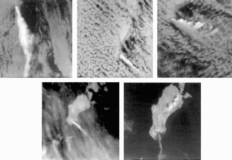 |
Figure 2. NOAA 5 satellite imagery, 5-9 February 1978, showing Unimak Island and vicinity. North orientations (arrow) are the same for each. A: (5 February 1978, 1036, infrared) Plume extends ~230 km S, rising to an estimated 8 km; black summit hot spot. B: (6 February 1978, 1141, infrared) Plume extends ~110 km SE; black summit hot spot. C: (7 February 1978, 1101, infrared) Plume at least 6 km high and ~160 km long, blown primarily SSE but some eastward shearing evident, probably by lower altitude winds. D: (8 February 1978, 1018, infrared) Plume extends 80 km SSE, at lower altitude than in C. E: (8 February 1978, 1018, visible, enlarged ~50% more than A-D) Weak plume curves SW to W about 100 km. Shishaldin is no longer active, 16 hours after its plume was visible in figure 1. The dark triangular area S of Westdahl is fresh ashfall, subtending an angle of about 95° and covering an area of ~300 km2. No ashfall is visible on Shishaldin. Courtesy of Jürgen Kienle and NOAA. |
Information Contacts: J. Kienle, Univ. of Alaska.
Ash emission increases
Peninsula Airways pilots reported unusually strong ash emission during overflights on 14 or 15, and 27 February. Ashfall, usually confined to the summit area, was occurring on the upper half of the volcano.
Information Contacts: G. Morgan, Peninsula Airways.
Plumes accompany eruption at nearby Pavlof
Activity accompanied some of the eruption at Pavlof (about 150 km ENE) [see 6:9 Pavlof; Pavlof and Shishaldin are in different time zones]. At 1315 on 25 September, NOAA weather satellite imagery revealed plumes emerging from both Shishaldin and Pavlof (Pavlof was also emitting a plume 4 hours earlier when weather clouds had last allowed a clear view of the area). By 1445, Shishaldin's plume had reached an altitude estimated at 6-7.5 km based on cloud top temperatures calculated from infrared imagery. The plume remained evident on the imagery until 1845, drifting E.
However, no activity from Shishaldin accompanied the ejection of a new cloud from Pavlof at 1845. Satellite images next showed a plume from Shishaldin at 0830 the next morning, when plumes from both volcanoes could be seen drifting ESE. On the next image with clear visibility, at 1315, no activity could be seen from Shishaldin. Reports from pilots through this period were very sketchy, but Shishaldin was said to be "steaming hard." No unusual activity was observed after 26 September by pilots or on satellite imagery.
Information Contacts: T. Miller and J. Riehle, USGS, Anchorage; S. McNutt and E. Hauksson, LDGO; W. Younker, NOAA/NESS, Anchorage.
Increased steam and ash emission
Anomalously large steam plumes with traces of ash have been noted for the past several months at Shishaldin by airline pilots and passengers. Diffuse ash layers extended from the volcano on 19 and 28 March, and steam and ash emission was seen on 6-7 May. Activity was less intense the next day, and had declined to minor steaming by 10 and 13 May. [See also 11:05].
Information Contacts: J. Reeder, ADGGS.
Steam plumes with some ash
The following supplements the preliminary report in 11:04. Large steam plumes that sometimes contained a little ash have been observed at Shishaldin since mid-March. The most vigorous activity was reported on 7 May, when a gray plume with streaks of dark ash extended 130 km S of the volcano at 3.6 km altitude. Moderate steaming was continuing in early June.
On 19 March at about 1325, James Dickson saw a yellow-brown wispy plume rise about 90 m. A nearly transparent brownish layer that extended SW was visible for more than 50 km. MarkAir captain Jerry Chisum noted another ash layer from Shishaldin on 28 March. He reported that the volcano is usually steaming from the summit, but several times in the past several months he noticed anomalously large steam plumes with traces of ash.
Chisum and several other pilots observed larger-than-normal steam and ash emission from Shishaldin on 6 and 7 May. On both days (at 1320) the plume rose at about a 45° angle to 3,400 m altitude (550 m above the summit) then drifted horizontally for at least 25 km. On 6 May the plume emission was continuous, but on the 7th the plume was puffing roughly every 20 minutes. Reeve Aleutian Airways captain Lee Goch flew within 25 km of the volcano on 6 May at 1350, noting that the plume appeared to contain traces of ash as it was pale gray. His photograph showed that the plume had drifted at least 40 km NE at about 3,600 m altitude. On 7 May at about 1300, Aleutian Air pilot Thomas Madsen observed a plume extending at least 130 km S at about 3,600 m altitude. The plume was distinctly gray with some streaks of dark ash. Less intense activity was reported by both Madsen and Goch on 8 May, when Madsen saw a grayish-white plume that drifted E. On 10 May, Reeve Aleutian captain Edward Livingston observed only minor steaming. Similar activity, with none of the steam rising above the summit, was seen by Goch on 13 May. Two days later, he saw a 90-m plume that drifted ~4 km NE.
On 6 June at 1350, Livingston saw a white steam plume that rose 1100 m above the summit. The next day at the same time, the plume was 1400 m high; both drifted a few kilometers SE. On 9 June at 1340, the plume was only 180 m high but drifted 40 km E. Goch noted only minor summit steaming on 10 June.
Information Contacts: J. Reeder, ADGGS.
Large steam plumes with some ash
Emission of large steam plumes, sometimes containing ash, were observed from aircraft and boats through August 1986. [The following reports describing activity at Shishaldin during 30 June-21 August 1986, were collected by John Reeder. Observers were Capt. Lee Goch (LG), Reeve Aleutian Airways; Capt. Jerry Chisum (JC), MarkAir; Jason Currier (JCu), on MarkAir flight; Theresa Dubber (TD) and Robert Senimore (RS), FAA, Cold Bay; and Tom Kizzia (TK), Anchorage Daily News aboard Alaska state ferry Tustumena.]
30 June (1900): White steam plume, drifting at least 5 km S. (LG)
19 July (1430): White steam plume with minor ash to 550 m above the summit, drifting more than 40 km E. (LG)
Mid-July: Steam with some ash drifted substantial distances. (JC)
20 August (1345): Voluminous steam with traces of ash. (JCu)
21 August (0900): 450-m white plume drifting SSE. (TD and RS)
21 August (afternoon): White plume to at least 450 m above the summit, drifting S at least 16 km. (TK)
Information Contacts: J. Reeder, ADGGS.
Steam and ash emission
Steam plumes that sometimes contained ash were observed by airplane pilots in early October 1986. [The following reports describing activity at Shishaldin during 2-10 October 1986 were collected by John Reeder. Observers were Capts. Jerry Chisum (JC) and Clint Schoenleber (CS), MarkAir; Stephanie Madsen (SM), Aleutian Air; Capts. Harold Black (HB), Lee Goch (LG), and James Fredenhagen (JF), Reeve Aleutian Airways; and John Reeder, ADDGS (JR).]
2 October (AM and PM): Above-average steam explosions with minor ash. (JC)
2 October (1145): Steam plume with minor ash extending at least 15 km SW. (SM)
3 October (1330-1336): Narrow steam plume to 400 m height; thin steam-and-ash plume drifted more than 40 km ESE; anomalous steam puffs with minor ash noted by JR at 1331-1332 and 1336. (HB, JR)
4 October (1520): Steam explosions sent plume to 800 m above the volcano; plume of vapor and minor ash extended about 50 km SSE; small amounts of black ash coated snow on N and NW flanks. (LG, JF, JR)
8 October: Normal 50-m steam plume. (CS)
10 October: Normal 50-m steam plume. (CS)
Information Contacts: J. Reeder, ADGGS.
Vigorous steam ejection
Vigorous steam ejection was observed on 20 December, and weak to moderate steaming was occasionally visible from late October through late December 1986. The 20 December steam ejection was considerably stronger than Shishaldin's typical activity, but significantly weaker in both size and ash content than the 6-7 May steam and ash emission. [The following reports describing activity at Shishaldin during 27 October-26 December 1986 were collected by John Reeder. Observers were Capts. Jerry Chisum (JC), MarkAir; Capts. Harold Black (HB) and Edward Livingston (EL), Reeve Aleutian Airways; Marcia Brown (MB), FAA, Cold Bay; Capt. Harold Wilson (HW), Peninsula Airways; and Rick Cales (RC), Cold Bay.]
27 October: Steam plume and haze to 80 km SW. (HB, EL)
17 November (1200-1400): Small steam plume to 20 km S; haze to 70 km S. (JC, EL)
18 November: Steam plume and haze to 65 km SW. (JC)
25 November: Unusual volume of steam, drifting ENE. (MB)
2 December: Very little steam (30-m plume). (MB)
15 December (1400): 300-m steam plume. (HW)
20 December (1030): Steam puffs to 600 m above the volcano. (HW)
20 December (1230): Steam blast rose to 2 km above summit in 10 minutes, remaining for 1 hour before slowly subsiding. (HW)
26 December (1800): 300-m vertical steam plume, drifting 8 km NE. (RC)
27-29 December: 300-m vertical steam plume. (MB)
Information Contacts: J. Reeder, ADGGS.
Small ash eruption followed by steaming
On 15 February at 1600, Marsha Brown observed a large dark-gray plume rising at least 600 m above the summit, drifting ENE. The plume had not been evident 2 hours earlier and lasted until at least 1830. Larger-than-average steam plumes were later observed on 21 and 26 February and 3 March. [The following reports describing activity at Shishaldin during 15 February-3 March 1987 were collected by John Reeder. Observers were Marsha Brown (MB) and Theresa Dubber (TD), FAA, Cold Bay; and Andy Livingston (AL), Don Munson (DM), and Lee Goch (LG), Reeve Aleutian Airways.]
15 February (1600): 600-m-high plume to the ENE. (MB)
21 February (1314): 150-m-high plume to the NE. (JF, AL)
26 February (0925): 300-m-high plume to the SW. (TD)
2 March (1254): Minor steam to the SW. (JF, DM)
3 March (1240): 300-m-high plume extending 20 km ENE. (LG)
Information Contacts: J. Reeder, ADGGS.
Steam plume observed rising to 1,800 m above the summit
A steam plume up to 1,800 m above the volcano was reported by pilots on 28 October. That same day, observers from Izembeck National Wildlife Refuge reported a steam-and-ash plume that rose to 1,200 m above the summit and drifted SE.
Information Contacts: Alaska Volcano Observatory.
Large steam plume
On 16 May a steam plume rose ~1,500 m above Shishaldin. Although large compared to typical day-to-day emissions, this is not unusual.
Information Contacts: Alaska Volcano Observatory.
Eruption sends ash plume above 10 km altitude
Based on satellite imagery and pilot reports received by the U.S. Federal Aviation Administration, an eruption began at 1830 on 23 December. Between 1830 and 2000 on 23 December, pilots reported an ash plume as high as 10.5 km altitude (35,000 feet); prevailing winds carried the plume primarily N and NW. Analysis of a satellite image from 1912 showed a possible small ash plume extending ~50 km NW. Possible very light ashfall was reported at approximately 0130 on 24 December in Cold Bay, 90 km NE; this ash would have been carried by westerly low-altitude winds.
Information Contacts: Alaska Volcano Observatory.
Steam plumes; thermal anomaly on satellite images
An eruption on 23 December was first reported by pilots who observed an ash plume as high as 10.5 km altitude (BGVN 20:11/12). Possible very light ashfall was reported a few hours later 90 km away. Large steam plumes were reported in early January, and an intermittent "hot spot" was detected on AVHRR satellite imagery during 5-26 January, in the vicinity of the summit crater. This thermal anomaly may reflect unusually high temperatures in the vicinity of the continuously active fumaroles in the summit crater. AVO received no additional pilot reports or other observations of eruptive activity after 26 January.
Information Contacts: Alaska Volcano Observatory.
Small steam-and-ash plume on 2 June
A visual observation of a small steam-and-ash plume was made by the U.S. National Weather Service at 1535 on 2 June from Cold Bay (90 km NE); the plume rose 300-450 m above the summit and drifted ~8 km downwind to the N. Installation of a seismic network of six stations was completed in July; testing and data collection to determine background seismicity is expected to be completed by mid-November.
Information Contacts: Alaska Volcano Observatory.
Steam plumes and thermal activity seen at summit
During the first week of February, National Weather Service personnel in Cold Bay, 93 km ENE of Shishaldin, observed anomalous steaming. On 9 February a vigorous steam plume rose as high as 1,830 m above the vent and a long plume drifted downwind. Satellite imagery taken that day showed a thermal anomaly at the vent in addition to the steam plume. The steam activity decreased during the week, becoming only light puffs rising a few meters above the vent; however, the thermal anomaly at the vent persisted. A newly installed seismic net recorded slightly elevated seismicity beginning at the end of January.
The hazard status was raised to Yellow on 18 February due to the persistence of the thermal anomaly and the identification of low-level seismic tremor. Pilots and ground observers reported a large steam plume rising to 5,800 m on 18 February. No ash was detected on satellite imagery. Cloudy weather precluded ground observations for most of the following week.
Shishaldin volcano, located near the center of Unimak Island in the eastern Aleutian Islands, is a spectacular symmetrical cone with a basal diameter of approximately 16 km. A small summit crater typically emits a noticeable steam plume with occasional small amounts of ash. Shishaldin is one of the most active volcanoes in the Aleutian volcanic arc, situated near that part of the arc where the maximum rate of subduction occurs. It has erupted at least 27 times since 1775. Major explosive eruptions occurred in 1830 and 1932, and eight historical eruptions have produced lava flows. Steam and minor ash emission began in March 1986 and continued intermittently through mid-February, 1987. A poorly documented short-lived eruption of steam and ash, perhaps as high as 10 km, occurred in December 1995 (BGVN 21:01). Fresh ash was noted on the upper flanks and crater rim but no specific eruptive event was identified for the deposits.
Information Contacts: Alaska Volcano Observatory, a cooperative program of a) U.S. Geological Survey, 4200 University Drive, Anchorage, AK 99508-4667, USA (URL: http://www.avo.alaska.edu/), b) Geophysical Institute, University of Alaska, PO Box 757320, Fairbanks, AK 99775-7320, USA, and c) Alaska Division of Geological & Geophysical Surveys, 794 University Ave., Suite 200, Fairbanks, AK 99709, USA.
Increased shallow seismicity precede April Strombolian eruptions
Low-level seismicity and a thermal anomaly visible in satellite imagery continued at Shishaldin during March, preceding Strombolian eruptions on 17 April. On many days no observations were obtained due to bad weather.
A new seismic net at Shishaldin recorded elevated seismicity beginning near the end of January. On 9 February a thermal anomaly appeared on satellite imagery and vigorous steam plumes were reported through the next week (BGVN 24:02). No ash was detected on the satellite imagery. Low-level tremor prompted the Alaska Volcano Observatory (AVO) to raise the Level of Concern Color Code to Yellow on 18 February. The tremor subsequently diminished, but seismicity remained above normal.
National Weather Service observers in Cold Bay, 90 km NE, reported that no steam plume was present during the first week of March, but that the upper summit was snow-free. Apparently, heating in the summit area caused the snow to melt. A shallow M 5.0 earthquake ~14 km SW of Shishaldin on 4 March was followed by hundreds of small aftershocks that persisted until late in the month.
Seismic activity, chiefly strong tremor, substantially increased above previous levels at 0800 on 7 April, causing AVO to raise the hazard status to Orange. Weather in the area was overcast with haze, preventing views of the summit area. The strong tremor declined by the afternoon and returned to previous levels. Tremor remained steady from 8 April without significant changes through 12 April, when the hazard status was decreased to Yellow. The thermal anomaly observed in satellite imagery persisted.
On 12 April a M 4.5 earthquake struck W of the volcano; aftershocks followed. Tremor increased markedly late on 13 April. This tremor episode lasted over one day and decreased somewhat for the next three days. AVO again raised the hazard status to Orange on 14 April.
AVO staff flying with Alaska State Troopers saw a minor Strombolian eruption at 1700 on 17 April. Incandescent blocks and spatter rose as high as 200 m above the vent, but at that time no lava had come over the crater rim. On the morning of 18 April, National Weather Service observers NW of the volcano both in Cold Bay and on a ship saw incandescent lava at the summit and snow melt running down the NW flank. A small steam plume with little or no ash developed as hot lava contacted snow at the summit. Tremor remained elevated.
On 19 April at 1145 a pilot saw a steam-and-ash plume that reached ~9 km altitude. In accord with this observation, tremor amplitudes increased dramatically after 1133 in the wake of a steady, two-day tremor increase. Observers interpreted these as signs of a significant eruption and raised the hazard status to Red. By early afternoon the eruption column reached at least 13.7 km altitude. The eruption lasted about 7 hours with one ash plume at higher elevations moving N and another, at lower elevations, S. Aviation warnings ("Graphic Volcanic Meteorological Impact Statements") for 0410-1610 on 19 April indicated two separate areas to avoid; one area spread ~300 km N over an elliptically shaped zone and the other, ~500 km S over a broadly spreading pattern that also included a lobe reaching ~375 km NW of Shishaldin (to Chignik). Late on the night of 19 April seismic tremor decreased substantially, but the Strombolian eruption continued at moderate levels.
On 20 April at about 0345, seismicity abruptly and significantly declined, indicating that explosive activity had subsided; still, satellite imagery after 0650 (1450 GMT) revealed a summit-crater thermal anomaly. Authorities decreased the hazard status to Orange. Seismic activity increased again about 1600. The increase in seismicity strengthened at about 2300 and on the morning of 21 April reached levels similar to those recorded in the hours before the explosive eruption on 19 April, and the hazard status returned to Red. Moderate Strombolian eruptions were thought to be occurring, though at the time satellite imagery failed to show a major ash cloud.
A moderate Strombolian eruption occurred through the night of 21 April. Seismicity became elevated and a very large thermal anomaly became visible on satellite imagery. Lava fountains shot tens of meters above the summit and satellite imagery indicated occasional steam and clouds of sparse ash extending for less than 50 km at altitudes under 5,000 m.
Information Contacts: Alaska Volcano Observatory (AVO), a cooperative program of a) U.S. Geological Survey, 4200 University Drive, Anchorage, AK 99508-4667, USA (URL: http://www.avo.alaska.edu/), b) Geophysical Institute, University of Alaska, PO Box 757320, Fairbanks, AK 99775-7320, USA, and c) Alaska Division of Geological & Geophysical Surveys, 794 University Ave., Suite 200, Fairbanks, AK 99709, USA.
Steam-and-ash plume on 19 April rose to 15-20 km and was carried to great distances
Strombolian eruptions, including forceful steam-and-ash plumes, peaked at Shishaldin on 19 April (BGVN 24:03) and continued well into May. The 19 April plume rose to 15-20 km and various components were carried in different directions (figure 3). As discussed further in the Atmospheric Effects section below, scientists studying atmospheric aerosols with a variety of satellite-based instruments as well as ground-based lidar detected atmospheric anomalies through at least late May; some at great distances from the volcano. The initial anomalies seen by satellite were clearly linked to the 19 April eruption, but at longer time intervals after the eruption and at greater distances from the source, this became less certain.
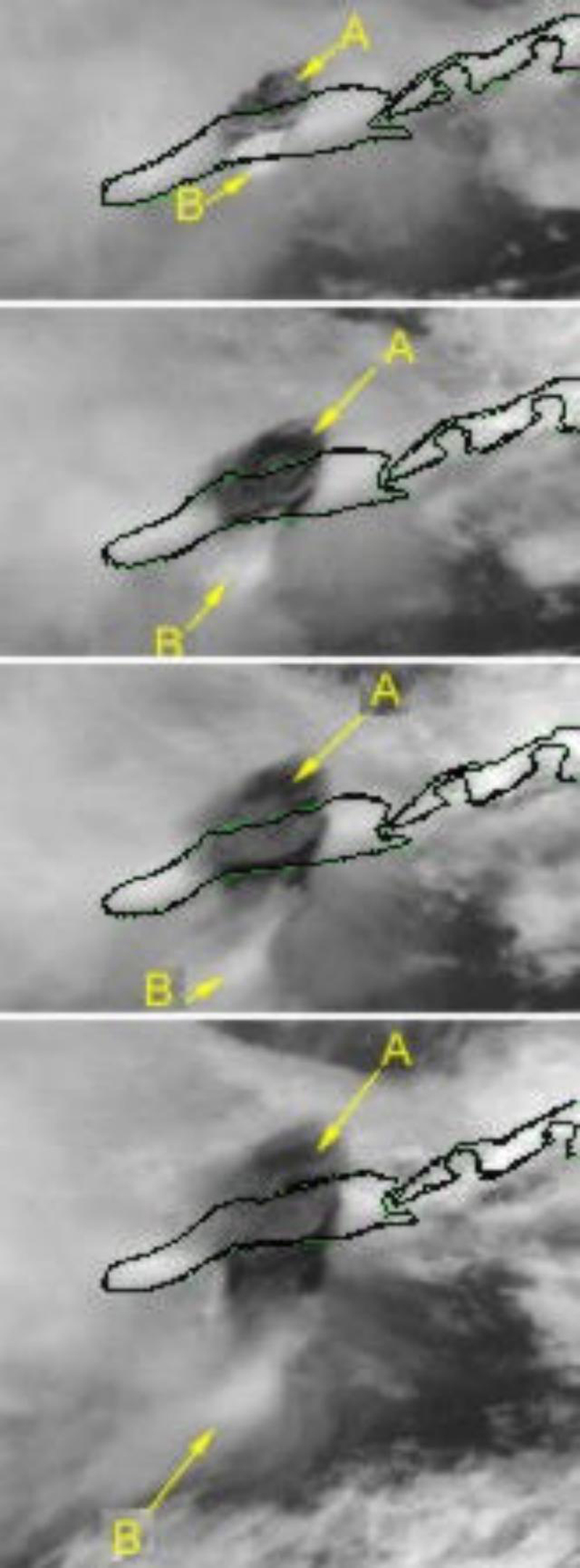 |
Figure 3. Detailed view of the spreading eruption cloud from Shishaldin on 19 April, taken from a series of images taken by the GOES 10 satellite (channel 1). Unimak Island is outlined. The top frame was imaged at 1200; the following frames at subsequent half-hour increments. The cloud labeled "A" was at higher altitude and moved N; cloud "B" was at lower altitude and moved S. Courtesy of NOAA/NESDIS. |
Moderate Strombolian eruptions and elevated seismicity continued following the initial forceful eruption and through the night of 22 April, . Lava fountaining to about 150 m above the summit coincided with satellite images of occasional steam and sparse ash clouds. These clouds extended ~48 km at altitudes less than 4.6 km. Satellite data during the first week of May showed a few small ash-poor plumes, but no thermal anomalies or other indicators of significant eruptive activity were seen.
The next significant reported event, on 13 May, occurred after a night with a small thermal anomaly in satellite imagery and weak tremor. The crew of a National Weather Service boat at the N end of False Pass, 30 km NE from the volcano, saw three puffs at ~1025. A plume rose 300 m above the summit. A pilot's report at 1155 confirmed the activity. Poor weather conditions may have thwarted observers' ability to see eruptive activity the following week and none was reported. At 2311 on 24 May a pilot reported a plume that rose to 6.1 km. Ash-rich steam in a plume was visible in satellite imagery at 1459 on 25 May, extending 160 km S from Shishaldin at an estimated altitude of ~4.6 km.
One of the most active volcanoes of the Aleutian Islands, the glacier-covered Shishaldin lies at the westernmost end of three large stratovolcanoes on the eastern half of Unimak Island. The volcano's frequent explosive activity has primarily consisted of Strombolian ash eruptions vented from its small summit crater, and occasional lava flows. The historical record of such events goes back to the 18th century.
Information Contacts: Alaska Volcano Observatory (AVO), a cooperative program of a) U.S. Geological Survey, 4200 University Drive, Anchorage, AK 99508-4667, USA (URL: http://www.avo.alaska.edu/), b) Geophysical Institute, University of Alaska, PO Box 757320, Fairbanks, AK 99775-7320, USA, and c) Alaska Division of Geological & Geophysical Surveys, 794 University Ave., Suite 200, Fairbanks, AK 99709, USA; NOAA/NESDIS Operational Significant Event Imagery Support Team, Interactive Processing Branch E/SP22, 5200 Auth Road, Camp Springs, MD 20746, USA (URL: https://www.nnvl.noaa.gov/).
Eruption ends after long ash plumes are emitted in late May
The eruption that began in mid-April (BGVN 24:03 and 24:04) ended in late May following blasts that sent ash plumes to 6 km altitude. No eruptive activity was observed or reported the week of 15-21 May, but the hazard status remained at Yellow due to persistent low-level seismicity and a summit thermal anomaly. A pilot report at 2311 on 24 May indicated an eruption plume up to 6 km altitude. A narrow ash-rich plume was seen in satellite imagery at 0659 on 25 May, extending about 160 km S from Shishaldin at an estimated altitude of 4.5 km. Following these observations the hazard status was raised to Orange, indicating that the volcano was in eruption. The plume continued to be seen on imagery at 1530, extending 175 km S, with low to moderate levels of seismicity being recorded.
Satellite imagery at 1000 on 26 May indicated that a narrow ash-rich plume continued to be emitted from the volcano, extending ~110 km SE at altitudes of up to 6 km; a pilot report at 1603 on 25 May indicated an ash-rich plume at ~5.5 km altitude. The plume seen on satellite imagery at 1645 extended at least 160 km ESE. Seismicity was at low to moderate levels beneath the volcano. Satellite imagery during the night of 26-27 May showed a continuous narrow ash-rich plume extending ~800 km ESE from the volcano at altitudes of 4.5-6 km until about 0100 on 27 May. After that time the plume became detached from the volcano and had diminished significantly by 0300. A small thermal anomaly in the summit crater was visible in a satellite image at 0908. A ground crew from AVO on the N flank of the volcano reported only white steam from the summit crater during 28 May.
Seismicity remained low through 1 June, and although the top of the volcano was visible no ash plume or thermal anomaly was seen in satellite imagery. The Level of Concern Color Code was therefore downgraded to Yellow. Although low-level seismicity continued, on 18 June AVO lowered the Level of Concern Color Code to Green based on the decline in activity over the previous month.
Information Contacts: Alaska Volcano Observatory (AVO), a cooperative program of a) U.S. Geological Survey, 4200 University Drive, Anchorage, AK 99508-4667, USA (URL: http://www.avo.alaska.edu/), b) Geophysical Institute, University of Alaska, PO Box 757320, Fairbanks, AK 99775-7320, USA, and c) Alaska Division of Geological & Geophysical Surveys, 794 University Ave., Suite 200, Fairbanks, AK 99709, USA.
Small phreatic explosions during September 1999-January 2000
The Alaska Volcano Observatory (AVO) reported on 21 January 2000 that investigations of recent seismic data had revealed evidence for small explosions at Shishaldin. Later detailed study of the seismic records showed that the activity may have begun in as early as late September. The numbers of explosions varied from several to over 200/day, but no steam or ash plumes were observed by airborne or ground observers. Also, no thermal anomaly was observed in satellite imagery, indicating that lava had not reached the surface. It was thought that the explosions were phreatic, caused by the flashing of water to steam; these events may represent a local hazard within a few hundred meters of the vent but do not pose a hazard to aircraft. Small explosions continued at a similar rate through 28 January.
Small low-frequency seismic events, present at Shishaldin since June 1999, gradually increased in amplitude after 28 January, with a noticeable increase during 2-3 February. Seismic data continued to show the presence of small phreatic explosions. Reports of steam plumes were received during the week ending on 2 February, with heights reaching as high as ~900 m above the summit. However, no thermal anomaly was observed in satellite imagery and no seismic tremor was identified; both were seen prior to the last eruptive episode in April and May 1999 (BGVN 24:03, 24:04, 24:08). Due to the increased activity, AVO raised the Level of Concern Color Code to Yellow on 3 February, indicating that the volcano is restless and an eruption may occur.
No appreciable number of seismic events were detected after 4 February; that was also the last day that small explosions were observed. Small low-frequency seismic events continued through 11 February, but at a slower rate and slightly lower amplitude. By 18 February seismic activity had declined significantly with no thermal anomalies or observations of unusual activity, so the hazard status was changed back to Green, indicating normal seismicity and surface activity.
Small low-frequency seismic events and very low-level tremor was recorded through 3 March, although at or below the levels observed in the months prior to the 19 April 1999 eruption. Low-level seismicity continued through the end of March. Vigorous steaming was reported in the second half of March, but no thermal anomaly observed in satellite imagery.
Information Contacts: Alaska Volcano Observatory (AVO), a cooperative program of a) U.S. Geological Survey, 4200 University Drive, Anchorage, AK 99508-4667, USA (URL: http://www.avo.alaska.edu/), b) Geophysical Institute, University of Alaska, PO Box 757320, Fairbanks, AK 99775-7320, USA, and c) Alaska Division of Geological & Geophysical Surveys, 794 University Ave., Suite 200, Fairbanks, AK 99709, USA.
Thermal anomaly and small explosions on 11 August
The Alaska Volcano Observatory (AVO) reported on 11 August that recent satellite data indicated a weak thermal anomaly at Shishaldin's summit, although no known seismic activity occurred above background levels in the area. Pilot reports did not disclose any noticeable change in steam emission from the summit crater. Accordingly, the AVO decided to keep the Level of Concern Color Code for Shishaldin at Green.
After 11 August, clear days allowed unobstructed remote sensing, and satellite observations, which suggested no further thermal anomaly. On 18 August, AVO issued an update stating that new seismic data analysis showed several small explosions occurring coeval with the thermal anomaly reported on 11 August. These explosions were similar to those observed throughout 1999 and in early 2000 (BGVN 24:02-24:04, 24:08, and 25:02). The thermal anomaly and seismic disturbances did not recur in the remainder of August, however, so the hazard status remained Green.
Information Contacts: Alaska Volcano Observatory (AVO), a cooperative program of a) U.S. Geological Survey, 4200 University Drive, Anchorage, AK 99508-4667, USA (URL: http://www.avo.alaska.edu/), b) Geophysical Institute, University of Alaska, PO Box 757320, Fairbanks, AK 99775-7320, USA, and c) Alaska Division of Geological & Geophysical Surveys, 794 University Ave., Suite 200, Fairbanks, AK 99709, USA.
Seismicity increases briefly during mid-May 2002
During mid-May 2002, the Alaska Volcano Observatory (AVO) detected an increase in background seismicity at Shishaldin that lasted for about one week. There was an increase in the number of located shallow low-frequency earthquakes and several 2-3-minute-long tremor-like signals that were inferred to be from a deep source. No thermal anomalies were visible on satellite imagery and there were no eyewitness reports of anomalous volcanic activity. Shishaldin remained at Concern Color Code Green ("volcano is in quiet, "dormant" state"). The last reported activity at Shishaldin included a thermal anomaly and small explosions during August 2000 (BGVN 25:08).
Information Contacts: Alaska Volcano Observatory (AVO), a cooperative program of a) U.S. Geological Survey, 4200 University Drive, Anchorage, AK 99508-4667, USA (URL: http://www.avo.alaska.edu/), b) Geophysical Institute, University of Alaska, PO Box 757320, Fairbanks, AK 99775-7320, USA, and c) Alaska Division of Geological & Geophysical Surveys, 794 University Ave., Suite 200, Fairbanks, AK 99709, USA.
Seismic unrest and modest ash plumes in 2004
The last report on Shishaldin (BGVN 27:05) described an increase in backround seismicity in mid-May 2002. Specifically, there was an increase in shallow low-frequency earthquakes and several tremor-like signals. However, because there were no thermal anomolies visible on satellite imagery, and no reports of anomalous volcanic activity, Shishaldin remained at Concern Color Code Green.
Activity during August 2002. On 16 August 2002, the Alaska Volcano Observatory (AVO) received notification of a pilot report, via the National Weather Service (NWS) Alaska Aviation Weather Unit (AAWU), of volcanic activity. The pilot report indicated that Shishaldin appeared to be erupting, producing steam and dark clouds to 3.2 km altitude that moved to the NW-SE. A NWS observer in Cold Bay, ~ 100 km E of the volcano, reported a steam-rich plume coming from Shishaldin. As per operating policy, the AAWU issued an "eruption SIGMET" advising the aviation community of the possibility of airborne volcanic ash. Upon receiving the pilot report, the AVO immediately analyzed seismic and satellite data and determined that Shishaldin was at a normal background state and had not erupted. Further discussions with the observer in Cold Bay indicated that the steam plume was not uncommon. The last significant ash-producing eruptions of Shishaldin occurred during April-May 1999. Since that time, low-frequency seismic events and occasional steam plumes have characterized activity at the volcano. Shishaldin remained at Concern Color Code Green.
Activity during April-May 2004. The AVO raised the Concern Color Code at Shishaldin from Green to Yellow on 3 May due to unusual seismicity during the previous week. Seismicity changed from discrete earthquakes to more continuous ones, and tremor was observed for the first time since the most recent eruption ended in May 1999. Airwaves (acoustical waves traveling in air) accompanying earthquakes were recorded by the seismic network, suggesting that the source of seismicity had become more shallow. Satellite data showed no significant increase in ground temperature, nor had there been reports of increased steaming. However, AVO warned that activity at Shishaldin could increase rapidly and increased the frequency of their seismic-data analysis.
Seismic unrest continued during 30 April to 7 May, and was characterized by sequences of volcanic earthquakes and seismic tremor. The number of airwaves recorded by the seismic network diminished in comparison to the previous week, with weaker signals recorded.
Thermal anomalies at the summit were observed on satellite imagery under optimal viewing conditions. Retrospective analysis confirmed that these data, as well as similar signals observed in January 2004, were the first observed since August 2000. AVO saw no signs that an eruption was imminent. Shishaldin remained at Concern Color Code Yellow throughout the month.
During 8-14 May seismic unrest continued, characterized by sequences of volcanic earthquakes, small explosions, and seismic tremor. A weak thermal anomaly observed at the summit on 11 May was similar to those detected occasionally since January 2004. On 16 May, a pilot reported an ash plume that rose ~ 300 m above the volcano's summit. Satellite imagery from 17 May (figure 4) showed a vigorous plume, possibly containing small amounts of ash, emanating from the summit. Seismic unrest during 14-21 May was characterized by weak seismic tremor and small explosions, and during 21-28 May also included occasional discrete low-frequency earthquakes. In addition, small explosion signals were recorded by a pressure sensor. Meteorological clouds obscured views of the volcano. Satellite data acquired at 0823 UTC (0023 ADT) on 29 May showed that the crater to continue to be warmer than background temperatures.
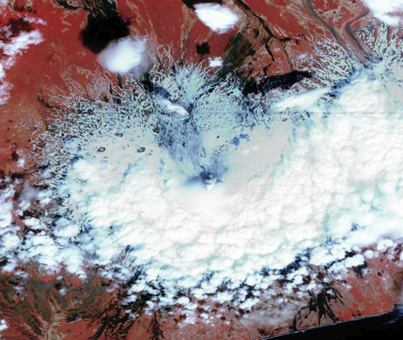 |
Figure 4. Shishaldin as depicted by an ASTER false color (image with bands 3, 2, and 1 as RGB and cloud/plume detail added with a semi-transparent band 4) taken 17 May 2004. The summit crater is shrouded by clouds, but a small plume that appears to contain ash is blowing toward the N. Dark streaks on the northern flanks may be partly from a light dusting of ash; however, other dark streaks appear as darker features melting through the snow. Courtesy of AVO. |
Activity during June-July 2004. Seismic unrest continued during 18 June-2 July, characterized by weak seismic tremor and occasional discrete low-frequency earthquakes. At roughly 0800 ADT on 24 June, pilots reported steam rising at least 100 m above Shishaldin's cone. Around that time, a possible weak thermal anomaly was visible on satellite imagery. Shishaldin remained at Concern Color Code Yellow.
Information Contacts: Alaska Volcano Observatory (AVO), a cooperative program of a) U.S. Geological Survey, 4200 University Drive, Anchorage, AK 99508-4667, USA (URL: http://www.avo.alaska.edu/), b) Geophysical Institute, University of Alaska, PO Box 757320, Fairbanks, AK 99775-7320, USA, and c) Alaska Division of Geological & Geophysical Surveys, 794 University Ave., Suite 200, Fairbanks, AK 99709, USA.
Pilot report of ash plume in February 2008
Previously reported activity at Shishaldin included the onset of tremor and some unusual earthquakes. For at least one day in July 2004 small ash plumes rose above the summit (BGVN 29:06).
In 2008, only one instance of an ash plume was reported. According to the Anchorage VAAC a pilot reported a small ash plume at an altitude of 3 km on 12 February. The ash plume was not confirmed by satellite imagery or ground observations. AVO did not report any unusual activity during this time. Shishaldin typically emits a relatively steady steam plume, as seen on 2 September 2008 (figure 5).
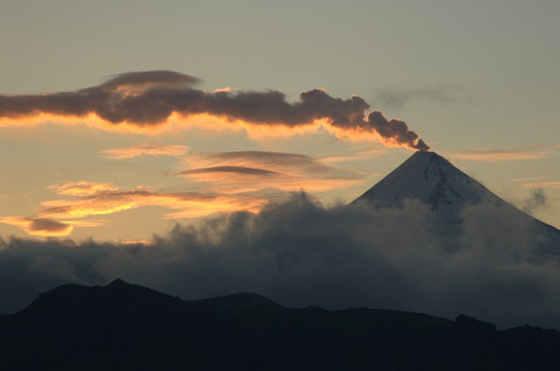 |
Figure 5. Shishaldin and a steam plume at sunset taken from a helicopter on 2 September 2008. Image courtesy of Cyrus Read and Alaska Volcano Observatory / U.S. Geological Survey. |
Information Contacts: Alaska Volcano Observatory (AVO), a cooperative program of the U.S. Geological Survey, 4200 University Drive, Anchorage, AK 99508-4667, USA (URL: http://www.avo.alaska.edu/), the Geophysical Institute, University of Alaska, PO Box 757320, Fairbanks, AK 99775-7320, USA, and the Alaska Division of Geological and Geophysical Surveys, 794 University Ave., Suite 200, Fairbanks, AK 99709, USA; Anchorage Volcanic Ash Advisory Center (VAAC), Alaska Aviation Weather Unit, NWS NOAA US Dept of Commerce, 6930 Sand Lake Road, Anchorage, AK 99502-1845, USA (URL: http://www.ssd.noaa.gov/).
Start of a low-level eruption in January 2014
Shishaldin, located on Unimak Island, is one of the most active volcanoes within the Aleutian Islands (figure 6). [Our last Bulletin report (BGVN 33:08) discussed activity at Shishaldin in February 2008, when a pilot reported a 3 km altitude ash plume. This report summarizes activity] from January to December 2009 and from January 2014 to March 2015. During 2009, Shishaldin emitted steam plumes, generated thermal anomalies, and underwent several episodes of tremor[; information for 2009 drew heavily on McGimsey and others (2014)]. From 2014 through March 2015, Shishaldin experienced elevated surface temperatures, steam emissions, and starting in March 2014, an ongoing low-level lava eruption within the summit crater that occasionally deposited ash on the upper flanks. As of March 2015, this low-level eruption continued. Considerable information in this report was found in material released by the Alaska Volcano Observatory (AVO).
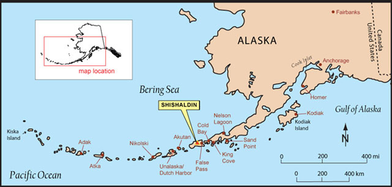 |
Figure 6. Map showing the location of Shishaldin. The volcano is located near the center of Unimak Island, and is the tallest peak and one of the most active volcanoes within the Aleutians Islands. False Pass, located 38 km to the NE, is the closest town. Map is courtesy of Alaska Volcano Observatory and Alaska Division of Geological & Geophysical Surveys. |
Activity during January-December 2009. According to AVO, activity began on 5 January (± 1 month) and ended on 16 August, and was characterized as a questionable eruption. According to McGimsey and others (2014), increased seismicity, small steam plumes as well as thermal anomalies characterized activity during 2009. Steam plumes are considered normal at Shishaldin according to McGimsey and others (2014).
McGimsey and others (2014), stated that there was an increase in observed thermal anomalies at Shishaldin in early January 2009. On 5-6 January, an AVHRR satellite image of Unimak Island showed a thermal anomaly centered on Shishaldin's summit crater. The anomaly reached a 2-pixel size on 6 January. There was also a slight increase in seismicity. These observations indicated a clear departure from background conditions. On 6 January, AVO increased Shishaldin's Aviation Color Code (ACC) from Green to Yellow and the Volcano Alert Level from Normal to Advisory. That day, pilots and ground observers reported a constant steam plume rising ~300 m above the summit and drifting 16-25 km SE (McGimsey and others, 2014).
Over the next few days, AVO continued observing a thermal anomaly in satellite images. On 7 January 2009, AVO received both a pilot report and observations from Cold Bay (93 km to the NE, figure 6) noting a vigorous steam plume rising from Shishaldin. On 8 January, satellite images showed a steam-filled crater with no ash on the flanks (McGimsey and others, 2014). AVO's 9 January 2009 Weekly Update stated "Although detection of a thermal anomaly is rare at this volcano, it is not certain that this unrest will lead to an eruption. A thermal anomaly was observed in the months leading up to the last significant eruption at Shishaldin [that occurred] in 1999; this fact, combined with the likelihood that an eruption at Shishaldin could occur with little or no seismic precursors, drove AVO's decision to raise the Color Code and Alert Level."
On 11 January 2009, a photo captured by a pilot showed pulsing steam plumes. Two days later, AVO seismologists identified a minor, low-amplitude tremor that persisted for a few weeks. According to McGimsey and others (2014), during the next few weeks, seismicity remained low, a few thermal anomalies were detected, and steaming was observed.
According to AVO's 13 February 2009 Weekly Update, a very weak thermal anomaly was detected on 3 February. The Update went onto say that on 11 February, the ACC was downgraded to Green and the Volcano Alert Level lowered to Normal, due to Shishaldin's return to background conditions. That Update also mentioned that seismic activity had remained low, since decreasing to background levels in late December 2008.
McGimsey and others (2014) reported that over the next seven weeks (mid-February to early April 2009) occasional thermal anomalies were observed along with continuous low-level tremor, which was not considered unusual. On 7 April, a pilot reported that he saw Shishaldin steaming more vigorously than he had previously observed during his weekly flights past Shishaldin over the last 16 months. That day, a thermal anomaly was also observed in satellite imagery (McGimsey and others, 2014).
On 20 April 2009, thermal activity at Shishaldin's summit spiked based on multiple thermal anomalies containing saturated pixels observed in satellite imagery (McGimsey and others, 2014). According to McGimsey and others (2014), these anomalies indicated high ground temperatures (greater than 300°C). This level of thermal activity was last seen before Shishaldin's eruption in 1999. On 5 May, a pilot reported steaming from Shishaldin and a passenger on a different flight reported dark-colored linear features on the N side of the summit. According to McGimsey and others (2014), these linear features were later interpreted as minor streams of dirty water trailing downslope.
McGimsey and others (2014) reported that throughout June 2009, thermal anomalies were detected on about one third of days, with a particularly strong anomaly being recorded on 9 June. No unusual seismic activity was noted. On the night of 25 June, an ASTER thermal infrared satellite image captured a thermal anomaly and a 22 km-long steam plume extending E-NE from Shishaldin. Then on 29 June, an observer in Cold Bay (93 km NE) reported increased steaming at Shishaldin over the past few days.
In the first week of July 2009, thermal anomalies at Shishaldin increased in intensity, with a return of saturated pixels, indicating high ground temperatures. On 10 July, AVO increased the ACC from Green to Yellow and the Volcano Alert Level from Normal to Advisory, due to the increase and continued presence of thermal anomalies. Seismicity and deformation did not change significantly during this time and satellite data did not show any noteworthy SO2 emissions. On 13 July, emissions were detected in satellite imagery and a pilot reported a steam plume rising 600 m above Shishaldin and moving NW. On 15 July, the satellite-based Ozone Monitoring Instrument (OMI) detected a small cloud rich in SO2 that originated from Shishaldin. For the rest of July and the first half of August 2009, steaming was observed from Shishaldin's summit, when weather permitted. Thermal anomalies were also detected in satellite images during August; one example was on 16 August.
In mid-September 2009, pressure sensors at Shishaldin detected anomalous airwaves. According to McGimsey and others (2014), the airwaves could be indicative of minor explosions; however, in retrospective analysis of the data collected by the pressure sensors, the airwaves were found to be a common occurrence and linked to episodic gas bursts (examples of which were seen during 2003-2004). On 19 October 2009, due to the continued absence of thermal anomalies, a decrease in steam emissions and seismicity considered within background levels, AVO lowered the ACC to Green and the Volcano Alert Level to Normal. Besides a weak thermal anomaly detected on 2 November, Shishaldin remained quiet for the remainder of 2009.
Non-eruptive interval during 2010-2013. AVO reported no unusual activity at Shishaldin between the years 2010 and 2013. In 2010, 2012 and 2013, AVO uploaded photos of Shishaldin, some of which showed the volcano emitting steam (figure 7).
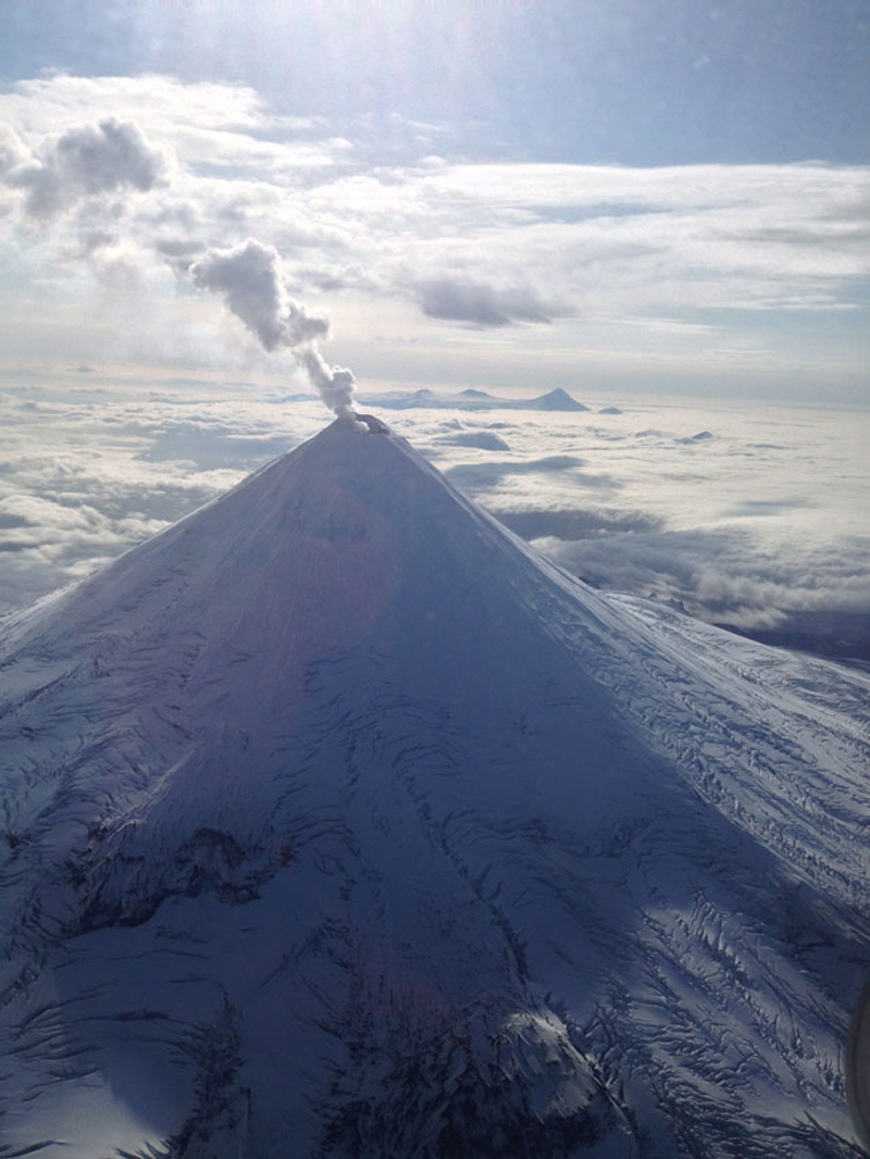 |
Figure 7. Photograph of Shishaldin emitting a steam plume on 14 September 2013. The photograph was taken from Korpiewski (2013). |
Activity during January 2014-March 2015. [AVO reported increased activity] on 28 January 2014 at Shishaldin. A low-level lava eruption within the summit crater then began in March 2014 and continued through March 2015. In addition to the ongoing eruption, there were also instances of heightened activity, one such example occurring around 28 October 2014, after AVO noted several days of elevated tremor and stronger thermal anomalies. AVO provides a description that synthesizes Shishaldin activity from late January 2014 through March 2015 on their website (as accessed on 1 May 2015). What follows is a quote of that description. For greater detail on activity during this interval, please see AVO's Weekly and Daily reports. Any information added to the quote by Bulletin editors has been [bracketed]. Bulletin editors also included pictures, depicting certain events that were described in the quote.
"On January 30, 2014, the Alaska Volcano Observatory raised the Volcano Alert Level to ADVISORY and the Aviation Color Code to YELLOW for Shishaldin, based on satellite observations of the previous days [figure 8]. Satellite observations included increased surface temperatures in the summit crater, as well as increased emissions of steam. Similar levels of unrest were last observed during 2009, and did not result in an eruption.
 |
Figure 8. Satellite image of Shishaldin on Unimak Island captured at 0838 UTC on 30 January 2014. The image shows the elevated surface temperatures in the summit crater of Shishaldin. According to the AVO caption for this image, "This mid-infrared image is scaled so that warm values are bright white and cold values (like high clouds are dark). The elevated surface temperatures are visible as the white pixels within the yellow circle that indicates the location of Shishaldin." Image was created by Dave Schneider and is courtesy of Alaska Volcano Observatory/ U.S. Geological Survey. |
"For the next week, persistent elevated surface temperatures were visible in satellite imagery of the summit crater during clear-weather intervals. On February 7, a possible volcanic cloud was observed in satellite images beginning around 1545 UTC (6:45 AKST). This cloud may have resulted from a small explosive event at the volcano. The event was small enough that it was not detected by the one working seismic station near the volcano, but it appears to coincide with a signal recorded by a nearby tiltmeter. Satellite images suggest that the cloud may have reached as high as [7.6 km above sea level], was ash-poor, and short-lived. There was no evidence of elevated surface temperatures observed in satellite data immediately following this event, suggesting it was primarily a gas event and very little to no hot material was produced or deposited on the flanks of the volcano.
"On March 19, elevated surface temperatures were again detected in satellite data, accompanied by ground-coupled airwaves seen in the seismic data. On March 28, after seeing persistent elevated surface temperatures since March 19, and continuing ground-couple airwaves, AVO data analysis showed temperatures in satellite images consistent with the eruption of lava within the summit crater. [The 28 March 2014 Volcanic Activity Notification (VAN) stated, 'The current activity appears to be confined to the deep summit crater and there have been no observations of lava on the flanks of the volcano or surrounding the summit crater.']
"During the week of April 11, minor ash deposits extending several hundreds of meters from the summit crater were observed in satellite imagery. Infrasound signals from Shishaldin were occasionally detected at sensors located at Dillingham [585 km to the NE] and Akutan Island [145 km to the SW].
"Throughout April, May, June, and July, elevated surface temperatures consistent with low-level eruptive activity in the summit crater were observed in satellite data, and small explosion signals were detected in seismic data. Occasional clear webcam views often showed minor steaming. An AVO overflight on August 10 showed hot, glowing material in the crater [figure 9]. On August 13, AVO received a pilot report of a low-level plume. [On 23 August, a pilot reported a steam-and-ash plume rose ~300 m above the summit and drifted NE.] Similar levels of activity continued throughout August, September, and October.
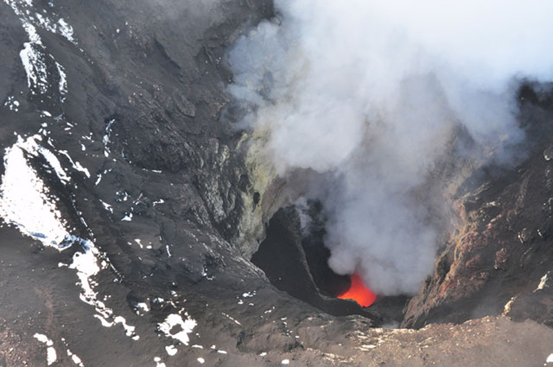 |
Figure 9. Photograph of incandescent material within Shishaldin's steaming summit crater and steam being emitted. This aerial photograph was captured on 10 August 2014 and shows ash deposited on the snow (in the left of the photo). Photo was captured by Cyrus Read and is courtesy Alaska Volcano Observatory/ U.S. Geological Survey. |
"On October 28, 2014, AVO noted an increase in intensity over the past several days, including elevated seismic tremor and stronger thermal anomalies. New deposits of ash and ballistics darkened the summit area, and the activity was also recorded on infrasound stations at Akutan and Dillingham. [On 26 October, clear webcam images revealed tephra deposits at the summit. The 28 October 2014 VAN stated that these new deposits indicated, '…the activity was energetic enough to eject material from a depth of several hundred meters (~600 ft) within the summit crater.'] This period of increased tremor lasted for several further days.
"On November 24, seismic activity at Shishaldin again increased.... This increased seismicity declined by November 27, but remained above background. [AVO's 28 November 2014 Weekly Update said, 'Although the level of seismic activity has declined during the week, it is likely that a low-level lava eruption is ongoing within the summit crater of the volcano.'] Weak, but above background seismicity, along with weakly elevated crater surface temperatures, continued in December 2014 and January 2015.
"In late January 2015, strongly elevated temperatures were observed in satellite images, consistent with active lava within the crater. [AVO's 23 January 2015 Weekly Update stated, 'Activity [over the past week was] consistent with what we have observed at Shishaldin during the past several months, which includes lava effusion in the crater with occasional production of small amounts of ash restricted to the volcano's upper flanks.'] A wispy, low-level ash emission was observed in webcam images on February 2, 2015.
"Throughout February and March 2015, clear satellite views often show elevated surface temperatures at the crater, seismicity remained above background, and low-level steam emissions were frequently seen in webcam images. It is likely that low-level eruptive activity continued within the summit crater."
References.
Alaska Volcano Observatory (AVO), Shishaldin reported activity, URL: https://www.avo.alaska.edu/volcanoes/volcact.php?volcname=Shishaldin, date accessed: 1 May 2015
Alaska Volcano Observatory (AVO), Shishaldin reported activity, Event specific information [for 2009], URL: https://www.avo.alaska.edu/volcanoes/activity.php?volcname=Shishaldin&page=basic&eruptionid=76, date accessed: 1 May 2015
Alaska Volcano Observatory (AVO), Shishaldin reported activity, Event specific information [for 2014], URL: https://www.avo.alaska.edu/volcanoes/activity.php?volcname=Shishaldin&page=basic&eruptionid=77, date accessed: 1 May 2015
Alaska Volcano Observatory/Alaska Division of Geological & Geophysical Surveys, 2009, URL: http://www.avo.alaska.edu/images/image.php?id=16190, date accessed: 1 May 2015
Korpiewski, J., U.S. Coast Guard, 2013, URL: http://www.avo.alaska.edu/images/image.php?id=57087, date accessed: 13 May 2015
McGimsey, R.G., Neal, C.A., Girina, O.A., Chibisova, Marina, and Rybin, Alexander, 2014, 2009 Volcanic activity in Alaska, Kamchatka, and the Kurile Islands - summary of events and response of the Alaska Volcano Observatory: U.S. Geological Survey Scientific Investigations Report 2013-5213, 125 p., URL: http://pubs.usgs.gov/sir/2013/5213/
Read, C., Alaska Volcano Observatory/U.S. Geological Survey, 2014, URL: http://www.avo.alaska.edu/images/image.php?id=66771, date accessed: 13 May 2015
Schneider, D., Alaska Volcano Observatory/U.S. Geological Survey, 2014, URL: http://www.avo.alaska.edu/images/image.php?id=57691, date accessed: 13 May 2015.
Information Contacts: Alaska Volcano Observatory (AVO), a cooperative program of the U.S. Geological Survey, 4200 University Drive, Anchorage, AK 99508-4667, USA (URL: http://www.avo.alaska.edu/), the Geophysical Institute, University of Alaska, PO Box 757320, Fairbanks, AK 99775-7320, USA, and the Alaska Division of Geological and Geophysical Surveys, 794 University Ave., Suite 200, Fairbanks, AK 99709, USA; Anchorage Volcanic Ash Advisory Center (VAAC), Alaska Aviation Weather Unit, and NWS NOAA US Dept of Commerce, 6930 Sand Lake Road, Anchorage, AK 99502-1845, USA (URL: http://vaac.arh.noaa.gov/).
Intermittent steam-and-ash plumes and thermal anomalies observed through October 2015
An eruption at Shishaldin that began in January 2014 was continuing as of March 2015 (BGVN 40:01). The Alaska Volcano Observatory reported increased activity on 28 January 2014 and a low-level lava eruption in the summit crater in mid-March. Thermal anomalies detected by MODIS (Moderate Resolution Imaging Spectroradiometer) satellite sensors first appeared on 30 January, but became more frequent after 4 May 2014.
Thermal data processed by MODVOLC detected anomalies up to 12 May 2015 (figure 10), but none after that through March 2016. Anomalies determined by MIROVA (Middle InfroRed Observation of Volcanic Activity) showed continuing activity through late August 2015 (figure 11).
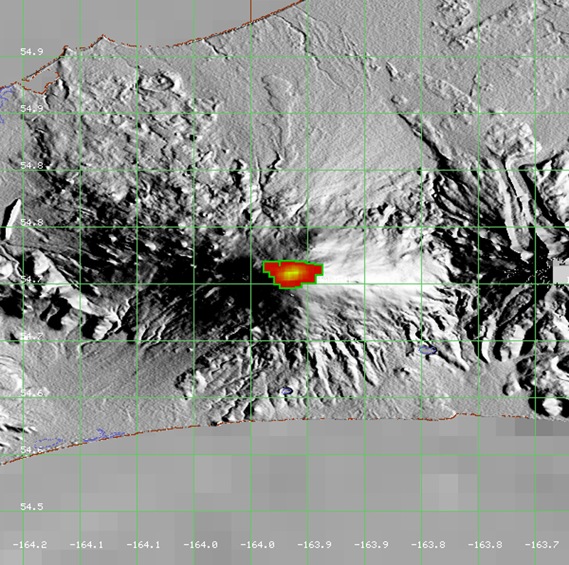 |
Figure 10. MODVOLC Thermal Alerts measured over Shishaldin volcano on Unimak Island, 30 January 2014-24 January 2015. Over this time there were 47 anomalies, with the most occurring in July (10), October (9), and November (8) 2014. Similar activity at the summit area continued to generate alerts through 12 May 2015. Each pixel represents a measured thermal alert for an area slightly larger than 1.5 km2. Courtesy of HIGP MODVOLC Thermal Alerts System. |
 |
Figure 11. Measured volcano radiative power for Shishaldin volcano for the year April 2015 through March 2016. The discontinuous nature of the anomalies may be due to atmospheric conditions rather than intermittent activity at the volcano. The data points in November 2015 are not at the summit; the source of those in December are unknown. Courtesy of MIROVA. |
The Alaska Volcano Observatory (AVO) reported that from January to November 2015, seismicity continued to be slightly elevated over background levels, indicating that low-level eruptive activity confined to the summit crater continued. Minor steaming from the summit was often observed, and on several dates steam and ash plumes were observed over the summit. During this time, the Aviation Color Code was at Orange and the volcanic Alert Level was at Watch.
No anomalous activity was observed in satellite data after weakly elevated surface temperatures were detected on 16 October 2015. In addition, low-amplitude seismic tremor continued but was likely not indicative of a continuing eruption. The Aviation Color Code was lowered to Yellow and the Volcano Alert Level was lowered to Advisory.
On 10 March 2016, AVO reported that there had been a continual decrease in thermal activity over the past several months; no anomalous activity had been observed in several clear satellite images since 13 January, when moderately elevated surface temperatures were detected. Airwaves generated by low-level explosive degassing had not been detected in infrasound data since 7 February. Low-amplitude seismic tremor was at background levels. In March 2016 the Color Code was lowered to Green and the Alert Level was lowered to Normal.
Information Contacts: Alaska Volcano Observatory (AVO), a cooperative program of a) U.S. Geological Survey, 4200 University Drive, Anchorage, AK 99508-4667 USA (URL: http://www.avo.alaska.edu/), b) Geophysical Institute, University of Alaska, PO Box 757320, Fairbanks, AK 99775-7320, USA, and c) Alaska Division of Geological & Geophysical Surveys, 794 University Ave., Suite 200, Fairbanks, AK 99709, USA (URL: http://www.dggs.alaska.gov/); Anchorage Volcanic Ash Advisory Center (VAAC), Alaska Aviation Weather Unit, NWS NOAA US Dept of Commerce, 6930 Sand Lake Road, Anchorage, AK 99502-1845(URL: http://vaac.arh.noaa.gov/); MIROVA (Middle InfraRed Observation of Volcanic Activity), a collaborative project between the Universities of Turin and Florence (Italy) supported by the Centre for Volcanic Risk of the Italian Civil Protection Department (URL: http://www.mirovaweb.it/); Hawai'i Institute of Geophysics and Planetology (HIGP), MODVOLC Thermal Alerts System, School of Ocean and Earth Science and Technology (SOEST), Univ. of Hawai'i, 2525 Correa Road, Honolulu, HI 96822, USA (URL: http://modis.higp.hawaii.edu/, http://modis.higp.hawaii.edu/)
Active lava lake and spattering on 23 July 2019; minor explosions and lava fountaining on 17 August
Recent activity at Shishaldin, located on Unimak Island within the Aleutian Islands, has included a lava eruption in the summit crater, thermal anomalies, elevated seismicity, and gas-and-steam and ash plumes (BGVN 41:11). This report describes minor gas-and-steam emissions, increased seismicity, thermal anomalies, lava fountaining accompanied by minor explosive activity, and a spatter cone. The primary source of information is the Alaska Volcano Observatory (AVO). This report updates activity through September 2019.
Volcanism was relatively low between March 2016 and early July 2019; increased seismicity and steam emissions were detected in December 2017, but the activity declined in February 2018. Elevated seismicity and some thermal anomalies accompanied by incandescence observed in satellite imagery (when not obscured by clouds) returned in mid-July 2019 (figure 12).
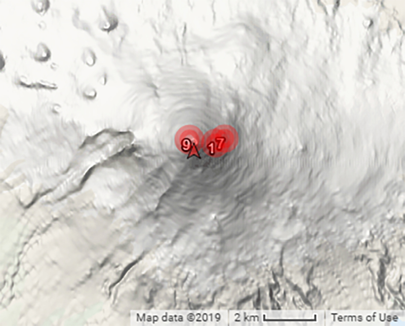 |
Figure 12. Summary graphic of MODVOLC thermal alerts measured over Shishaldin during July-September 2019. Courtesy of HIGP - MODVOLC Thermal Alerts System. |
Elevated surface temperatures and low-level seismic tremors remained elevated through September 2019 (figure 13). Field crews reported an active lava lake and minor spattering within the summit crater on 23 July 2019 (figures 14 and 15). Satellite imagery showed the presence of a small spatter cone and some lava flows within the summit crater on 28 July. A small steam plume was observed in satellite imagery and webcam images on 29 July, 20 August, and 30 September.
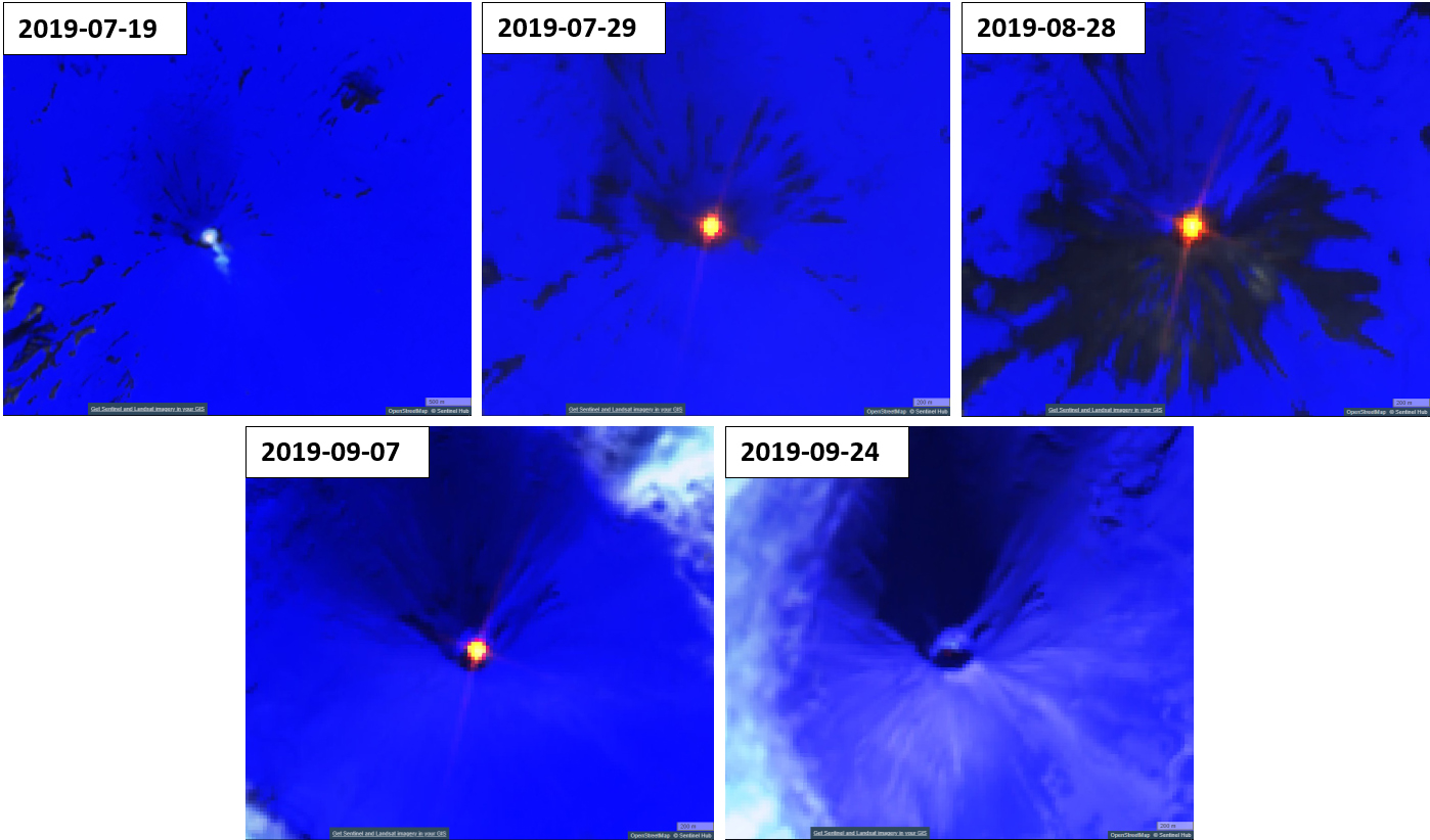 |
Figure 13. Sentinel-2 satellite imagery of Shishaldin showing detected thermal anomalies between the months of July and September 2019. Top left: Satellite image on 19 July showing a gas-and-steam plume. Top center: On 29 July a thermal anomaly is detected in the summit crater. Top right: On 28 August, the thermal anomaly is still present. Bottom left: On 7 September, the thermal anomaly continues. Bottom right: On 24 September, the power of the thermal anomaly significantly decreases. Atmospheric penetration satellite image (bands 12, 11, 8A) courtesy of Sentinel Hub Playground. |
 |
Figure 14. Photo of surface lava within the summit crater at Shishaldin taken on 23 July 2019. Photo by David Fee (color corrected); courtesy of Alaska Volcano Observatory (AVO). |
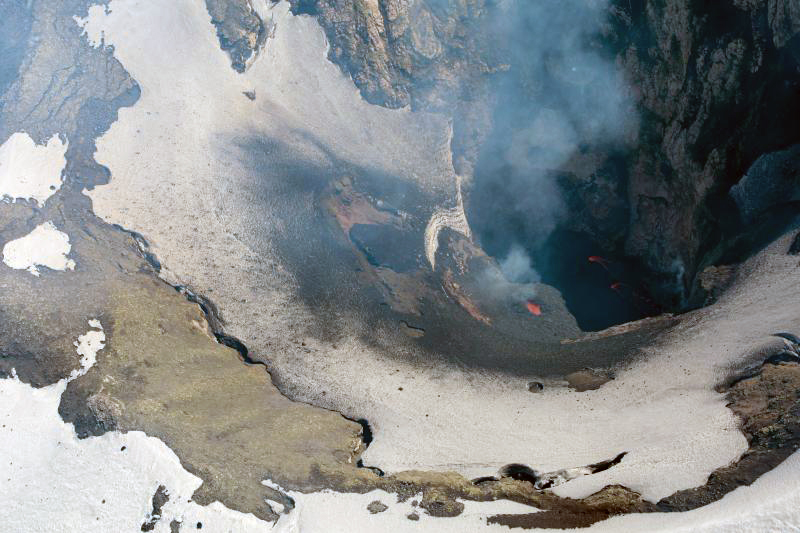 |
Figure 15. Photo of lava and a slightly growing spatter cone within the summit crater at Shishaldin taken on 23 July 2019. Photo by Dane Ketner (color corrected); courtesy of Alaska Volcano Observatory (AVO). |
On 17 August 2019, a video taken by NOAA during an overflight showed repetitive minor explosive activity and low-level lava fountaining within the summit crater. This activity may have continued through 24 September, according to AVO. The spatter cone grew slightly in August and September, partially filling the summit crater. Accompanying lava flows also grew slightly during this time.
Satellite data from 3 September showed SO2 emissions and elevated surface temperatures. Satellite imagery and tiltmeter data recorded a collapse and slumping of the summit crater floor, which may have occurred on 19 September. In the last few weeks of September, seismicity and surface temperatures decreased to slightly above background levels.
According to MIROVA (Middle InfraRed Observation of Volcanic Activity) data from MODIS satellite instruments, more frequent thermal anomalies were detected in mid-July 2019 and remained elevated through early September (figure 16).
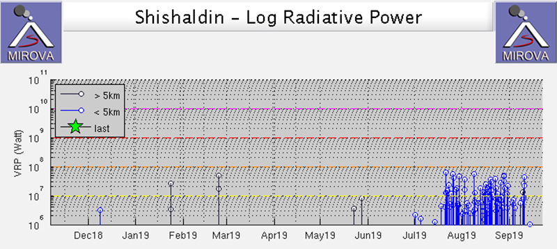 |
Figure 16. Thermal anomalies increased at Shishaldin from mid-July 2019 through early September and then abruptly stopped as recorded by MIROVA (log radiative power). Courtesy of MIROVA. |
Information Contacts: Alaska Volcano Observatory (AVO), a cooperative program of a) U.S. Geological Survey, 4200 University Drive, Anchorage, AK 99508-4667 USA (URL: https://avo.alaska.edu/), b) Geophysical Institute, University of Alaska, PO Box 757320, Fairbanks, AK 99775-7320, USA, and c) Alaska Division of Geological & Geophysical Surveys, 794 University Ave., Suite 200, Fairbanks, AK 99709, USA (URL: http://dggs.alaska.gov/); MIROVA (Middle InfraRed Observation of Volcanic Activity), a collaborative project between the Universities of Turin and Florence (Italy) supported by the Centre for Volcanic Risk of the Italian Civil Protection Department (URL: http://www.mirovaweb.it/); Hawai'i Institute of Geophysics and Planetology (HIGP) - MODVOLC Thermal Alerts System, School of Ocean and Earth Science and Technology (SOEST), Univ. of Hawai'i, 2525 Correa Road, Honolulu, HI 96822, USA (URL: http://modis.higp.hawaii.edu/); Sentinel Hub Playground (URL: https://www.sentinel-hub.com/explore/sentinel-playground).
Multiple lava flows, pyroclastic flows, lahars, and ashfall events during October 2019 through January 2020
Shishaldin is located near the center of Unimak Island in Alaska and has been frequently active in recent times. Activity includes steam plumes, ash plumes, lava flows, lava fountaining, pyroclastic flows, and lahars. The current eruption phase began on 23 July 2019 and through September included lava fountaining, explosions, and a lava lake in the summit crater. Continuing activity during October 2019 through January 2020 is described in this report based largely on Alaska Volcano Observatory (AVO) reports, photographs, and satellite data.
Minor steam emissions were observed on 30 September 2019, but no activity was observed through the following week. Activity at that time was slightly above background levels with the Volcano Alert Level at Advisory and the Aviation Color Code at Yellow (figure 17). In the first few days of October weak tremor continued but no eruptive activity was observed. Weakly elevated temperatures were noted in clear satellite images during 4-9 October and weak tremor continued. Elevated temperatures were recorded again on the 14th with low-level tremor.
 |
Figure 17. Alaska Volcano Observatory hazard status definitions for Aviation Color Codes and Volcanic Activity Alert Levels used for Shishaldin and other volcanoes in Alaska. Courtesy of AVO. |
New lava extrusion was observed on 13 October, prompting AVO to raise the Aviation Color Code to Orange and the Volcano Alert Level to Watch. Elevated surface temperatures were detected by satellite during the 13th and 17-20th, and a steam plume was observed on the 19th. A change from small explosions to continuous tremor that morning suggested a change in eruptive behavior. Low-level Strombolian activity was observed during 21-22 October, accompanied by a persistent steam plume. Lava had filled the crater by the 23rd and began to overflow at two places. One lava flow to the north reached a distance of 200 m on the 24th and melted snow to form a 2.9-km-long lahar down the N flank. The second smaller lava flow resulted in a 1-km-long lahar down the NE flank. Additional snowmelt was produced by spatter accumulating around the crater rim. By 25 October the northern flow reached 800 m, there was minor explosive activity with periodic lava fountaining, and lahar deposits reached 3 km to the NW with shorter lahars to the N and E (figure 18). Trace amounts of ashfall extended at least 8.5 km SE. There was a pause in activity on the 29th, but beginning at 1839 on the 31st seismic and infrasound monitoring detected multiple small explosions.
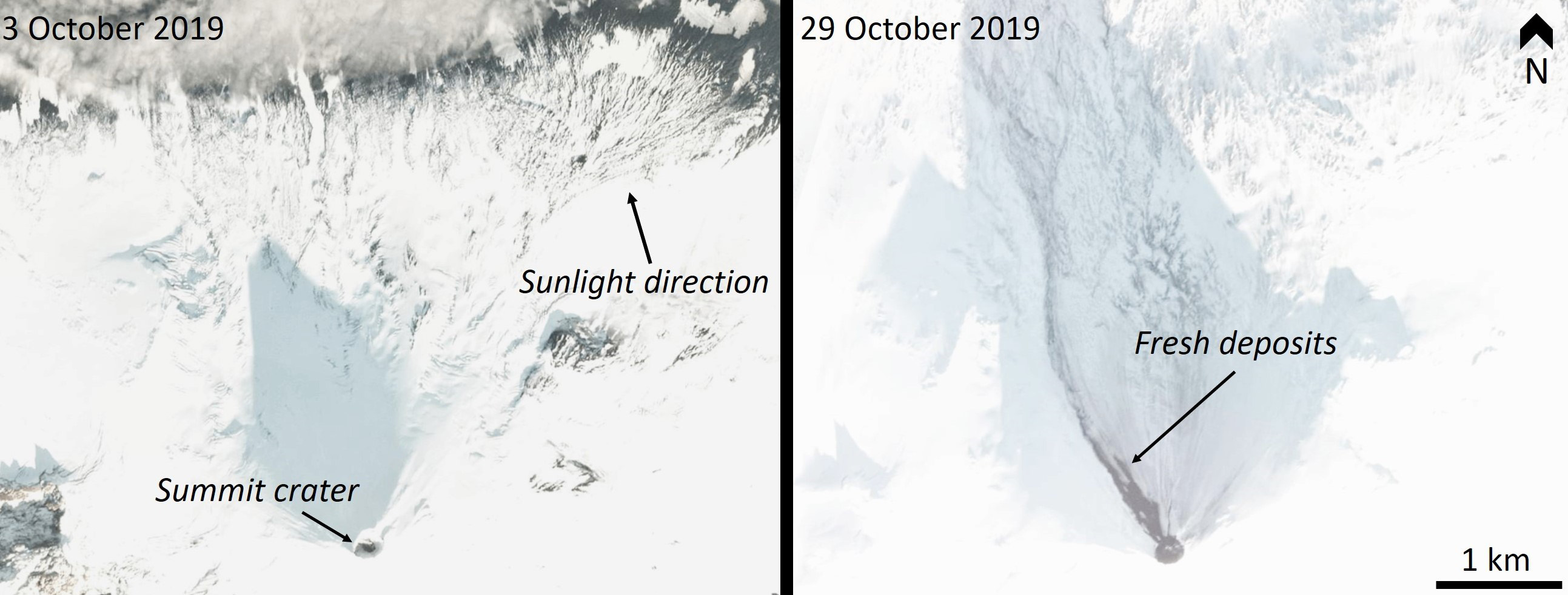 |
Figure 18. PlanetScope satellite images of Shishaldin on 3 and 29 October 2019 show the summit crater and N flank before and after emplacement of lava flows, lahars, and ashfall. Copyright PlanetLabs 2019. |
Elevated activity continued through November with multiple lava flows on the northern flanks (figure 19). By 1 November the two lava flows had stalled after extending 1.8 km down the NW flank. Lahars had reached at least 4 km NW and trace amounts of ash were deposited on the north flank. Elevated seismicity on 2 November indicated that lava was likely flowing beyond the summit crater, supported by a local pilot observation. The next day an active lava flow moved 400 m down the NW flank while a smaller flow was active SE of the summit. Minor explosive activity and/or lava fountaining at the summit was indicated by incandescence during the night. Small explosions were recorded in seismic and infrasound data. On 5 November the longer lava flow had developed two lobes, reaching 1 km in length. The lahars had also increased in length, reaching 2 km on the N and S flanks. Incandescence continued and hot spatter was accumulating around the summit vent. Activity continued, other than a 10-hour pause on 4-5 November, and another pause on the 7th. The lava flow length had reached 1.3 km on the 8th and lahar deposits reached 5 km.
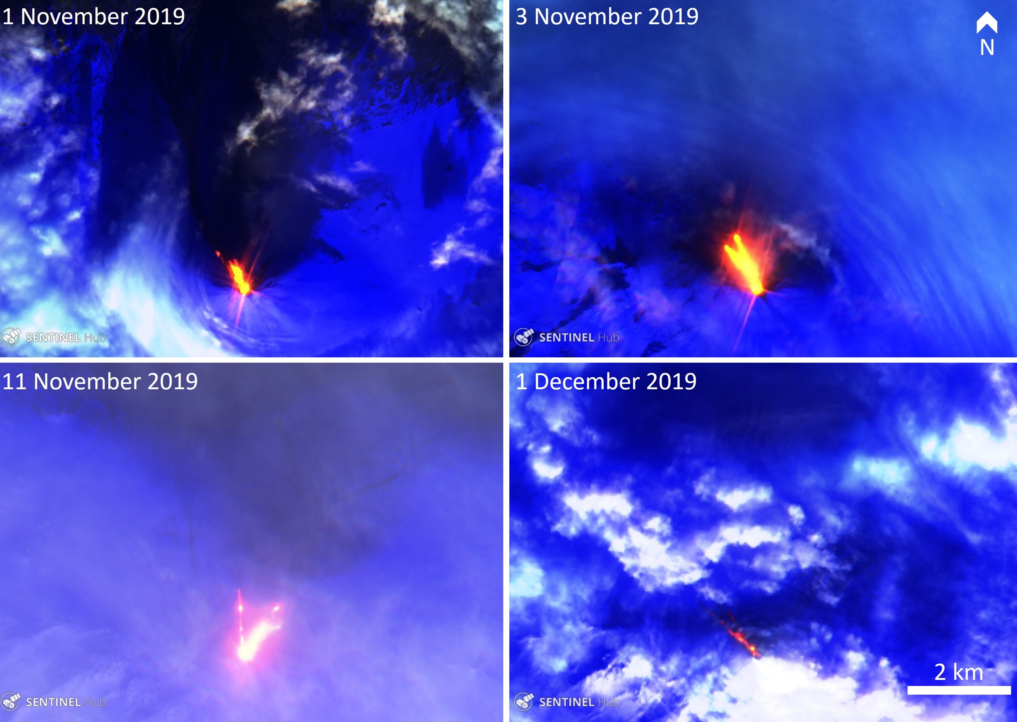 |
Figure 19. Sentinel-2 thermal satellite images show multiple lava flows (orange) on the upper northern flanks of Shishaldin between 1 November and 1 December 2019. Blue is snow and ice in these images, and partial cloud cover is visible in all of them. Sentinel-2 Urban rendering (bands 21, 11, 4) courtesy of Sentinel Hub Playground. |
After variable levels of activity for a few days, there was a significant increase on 10-11 November with lava fountaining through the evening and night. This was accompanied by minor to moderate ash emissions up to around 3.7 km altitude and drifting northwards, and a significant increase in seismicity. Activity decreased again during the 11-12th while minor steam and ash emissions continued. On 14 November minor ash plumes were visible on the flanks, likely caused by the collapse of accumulated spatter. By 15 November a large network of debris flows consisting of snowmelt and fresh deposits extended 5.5 km NE and the collapse of spatter mounds continued. Ashfall from ash plumes reaching as high as 3.7 km altitude produced thin deposits to the NE, S, and SE. Activity paused during the 17-18th and resumed again on the 19th; intermittent clear views showed either a lava flow or lahar descending the SE flank. Activity sharply declined at 0340 on the 20th.
Seismicity began increasing again on 24 November and small explosions were detected on the 23rd. A small collapse of spatter that had accumulated at the summit occurred at 2330 on the 24th, producing a pyroclastic flow that reached 3 km in length down the NW flank. A new lava flow had also reached several hundred meters down the same flank. Variable but elevated activity continued over 27 November into early December, with a 1.5-km-long lava flow observed in satellite imagery acquired on the 1st. On 5 December minor steam or ash emissions were observed at the summit and on the north flank, and Strombolian explosions were detected. Activity from that day produced fresh ash deposits on the northern side of the volcano and a new lava flow extended 1.4 km down the NW flank. Three small explosions were detected on the 11th.
At 0710 on 12 December a 3-minute-long explosion produced an ash plume up to 6-7.6 km altitude that dispersed predominantly towards the W to NW and three lightning strokes were detected. Ash samples were collected on the SE flank by AVO field crews on 20 December and analysis showed variable crystal contents in a glassy matrix (figure 20). A new ash deposit was emplaced out to 10 km SE, and a 3.5-km-long pyroclastic flow had been emplaced to the north, containing blocks as large as 3 m in diameter. The pyroclastic flow was likely a result from collapse of the summit spatter cone and lava flows. A new narrow lava flow had reached 3 km to the NW and lahars continued out to the northern coast of Unimak island (figure 21). The incandescent lava flow was visible from Cold Bay on the evening of the 12th and a thick steam plume continued through the next day.
 |
Figure 20. An example of a volcanic ash grain that was erupted at Shishaldin on 12 December 2019 and collected on the SE flank by the Alaska Volcano Observatory staff. This Scanning Electron Microscope images shows the different crystals represented by different colors: dark gray crystals are plagioclase, the light gray crystals are olivine, and the white ones are Fe-Ti oxides. The groundmass in this grain is nearly completely crystallized. Courtesy of AVO. |
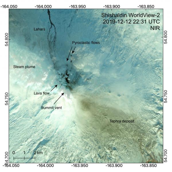 |
Figure 21. A WorldView-2 satellite image of Shishaldin with the summit vent and eruption deposits on 12 December 2019. The tephra deposit extends around 10 km SE, a new lava flow reaching 3 km NW with lahars continuing to the N coast of Unimak island. Pyroclastic flow deposits reach 3.5 km to the N and contain blocks as large as 3 m. Courtesy of Hannah Dietterich, AVO. |
A new lava flow was reported by a pilot on the night of 16 December. Thermal satellite data showed that this flow reached 2 km to the NW. High-resolution radar satellite images over the 15-17th showed that the lava flow had advanced out to 2.5 km and had developed levees along the margins (figure 22). The lava channel was 5-15 m wide and was originating from a crater at the base of the summit scoria cone, which had been rebuilt since the collapse the previous week. Minor ash emissions drifted to the south on the 19tt and 20th (figure 23).
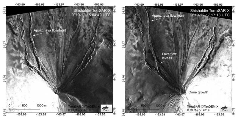 |
Figure 22. TerraSAR-X radar satellite images of Shishaldin on 15 and 17 December 2019 show the new lava flow on the NW flank and growth of a scoria cone at the summit. The lava flow had reached around 2.5 km at this point and was 5-15 m wide with levees visible along the flow margins. Pyroclastic flow deposits from a scoria cone collapse event on 12 December are on the N flank. Figure courtesy of Simon Plank (German Aerospace Center, DLR) and Hannah Dietterich (AVO). |
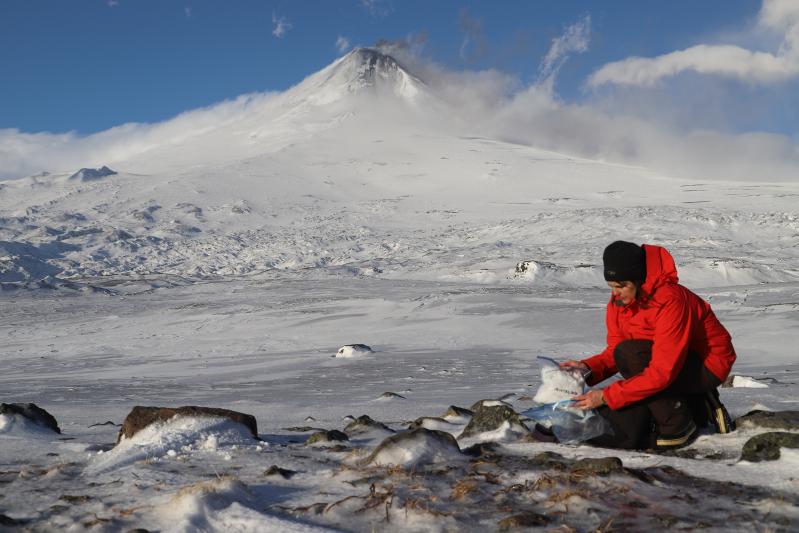 |
Figure 23. Geologist Janet Schaefer (AVO/DGGS) collects ash samples within ice and snow on the southern flanks of Shishaldin on 20 December 2019. A weak ash plume is rising from the summit crater. Photo courtesy of Wyatt Mayo, AVO. |
On 21 December a new lava flow commenced, traveling down the northern slope and accompanied by minor ash emissions. Continued lava extrusion was indicated by thermal data on the 25th and two lava flows reaching 1.5 km and 100 m were observed in satellite data on the 26th, as well as ash deposits on the upper flanks (figure 24). Weak explosions were detected by the regional infrasound network the following day. A satellite image acquired on the 30th showed a thick steam plume obscuring the summit and snow cover on the flanks indicating a pause in ash emissions.
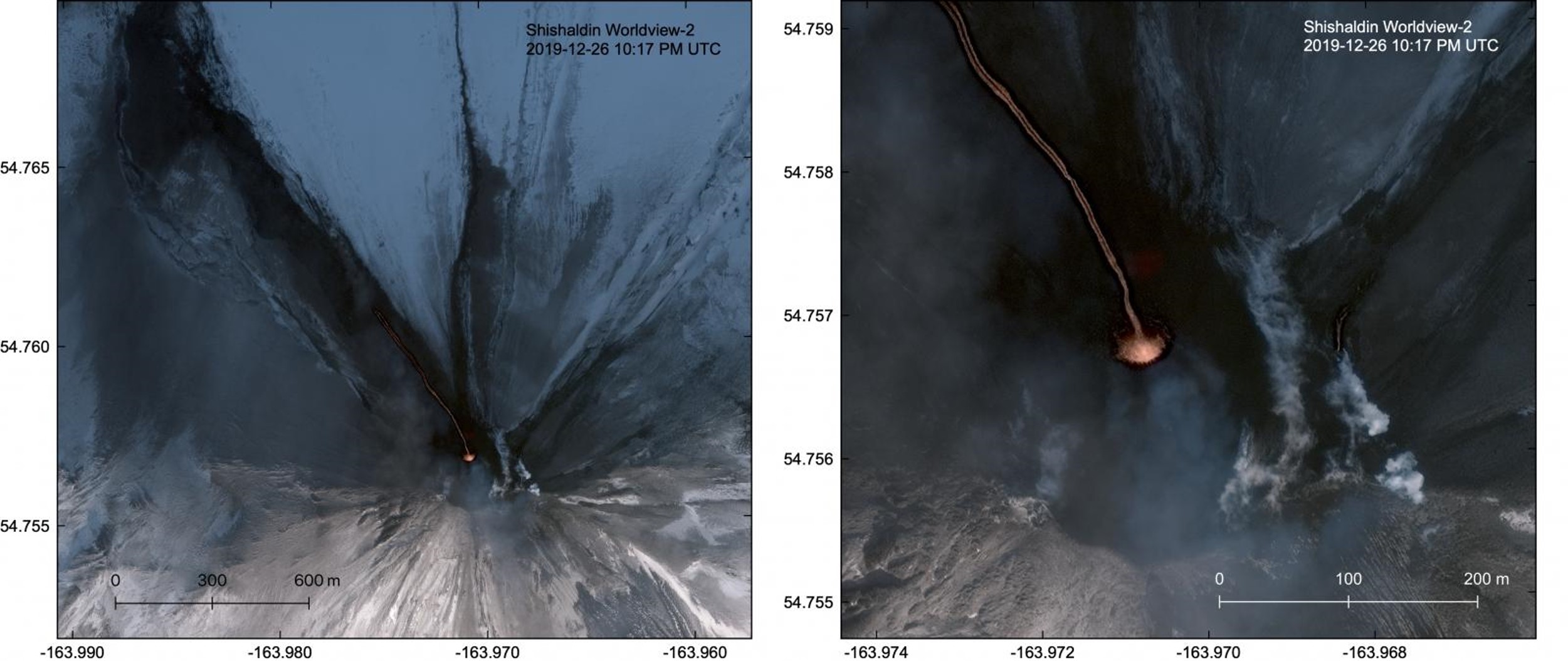 |
Figure 24. This 26 December 2019 WorldView-2 satellite image with a close-up of the Shishaldin summit area to the right shows a lava flow extending nearly 1.5 km down the NW flank and a smaller 100-m-long lava flow to the NE. Volcanic ash was deposited around the summit, coating snow and ice. Courtesy of Matt Loewen, AVO. |
In early January satellite data indicated slow lava extrusion or cooling lava flows (or both) near the summit. On the morning of the 3rd an ash plume rose to 6-7 km altitude and drifted 120 km E to SE, producing minor amounts of volcanic lightning. Elevated surface temperatures the previous week indicated continued lava extrusion. A satellite image acquired on 3 January showed lava flows extending to 1.6 km NW, pyroclastic flows moving 2.6 km down the western and southern flanks, and ashfall on the flanks (figure 25).
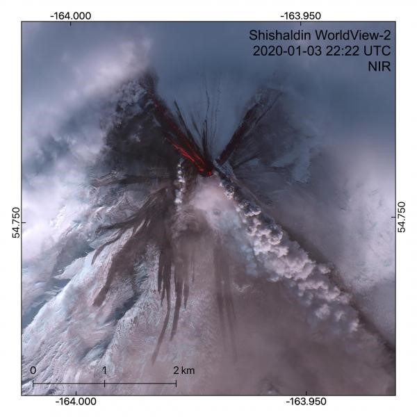 |
Figure 25. This WorldView-2 multispectral satellite image of Shishaldin, acquired on 3 January 2019, shows the lava flows reaching 1.6 km down the NW flank and an ash plume erupting from the summit dispersing to the SE. Ash deposits cover snow on the flanks. Courtesy of Hannah Dietterich, AVO. |
On 7 January the most sustained explosive episode for this eruption period occurred. An ash plume rose to 7 km altitude at 0500 and drifted east to northeast then intensified reaching 7.6 km altitude with increased ash content, prompting an increase of the Aviation Color Code to Red and Volcano Alert Level to Warning. The plume traveled over 200 km to the E to NE (figure 26). Lava flows were produced on the northern flanks and trace amounts of ashfall was reported in communities to the NE, resulting in several flight cancellations. Thermal satellite images showed active lava flows extruding from the summit vent (figure 27). Seismicity significantly decreased around 1200 and the alert levels were lowered to Orange and Watch that evening. Through the following week no notable eruptive activity occurred. An intermittent steam plume was observed in webcam views.
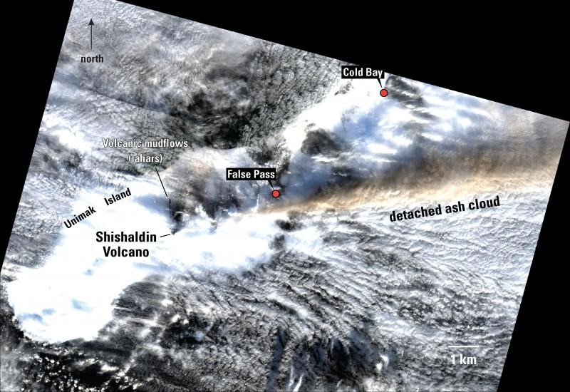 |
Figure 26. This Landsat 8 satellite image shows a detached ash plume drifts to the NE from an explosive eruption at Shishaldin on 7 January 2020. Courtesy of Chris Waythomas, AVO. |
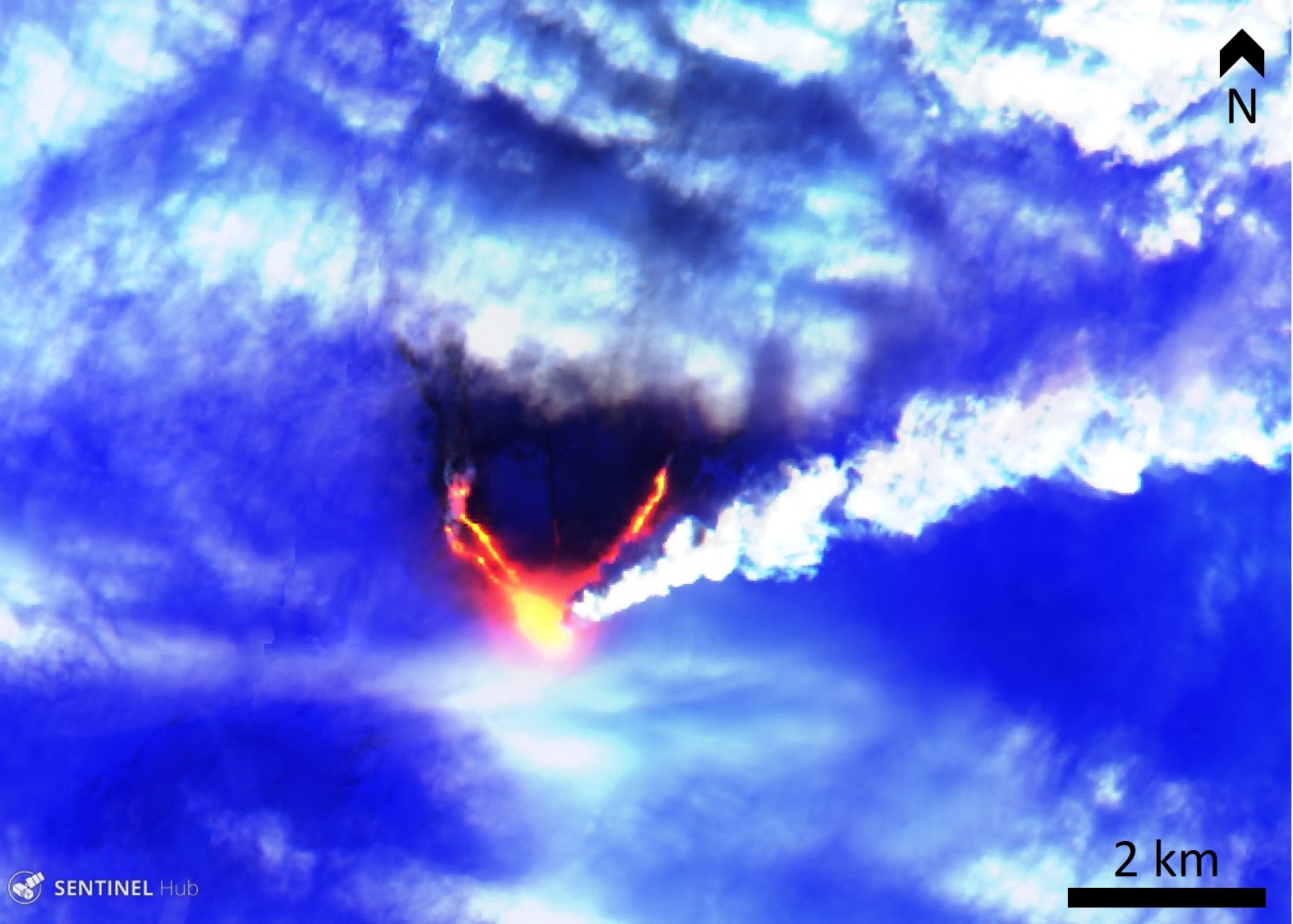 |
Figure 27. This 7 January 2019 Sentinel-2 thermal satellite image shows several lava flows on the NE and NW flanks of Shishaldin, as well as a steam plume from the summit dispersing to the NE. Blue is snow and ice in this false color image (bands 12, 11, 4). Courtesy of Sentinel-Hub playground. |
Eruptive activity resumed on 18 January with lava flows traveling 2 km down the NE flank accompanied by a weak plume with possible ash content dispersing to the SW (figure 28). A steam plume was produced at the front of the lava flow and lahar deposits continued to the north (figures 29 to 32). Activity intensified from 0030 on the 19th, generating a more ash-rich plume that extended over 150 km E and SE and reached up to 6 km altitude; activity increased again at around 1500 with ash emissions reaching 9 km altitude. AVO increased the alert levels to Red/Warning. Lava flows traveled down the NE and N flanks producing meltwater lahars, accompanied by elevated seismicity (figures 33). Activity continued through the day and trace amounts of ashfall were reported in False Pass (figure 34). Activity declined to small explosions over the next few days and the alert levels were lowered to Orange/watch shortly after midnight. The next morning weak steam emissions were observed at the summit and there was a thin ash deposit across the entire area. Satellite data acquired on 23 January showed pyroclastic flow deposits and cooling lava flows on the northern flank, and meltwater reaching the northern coast (figure 35).
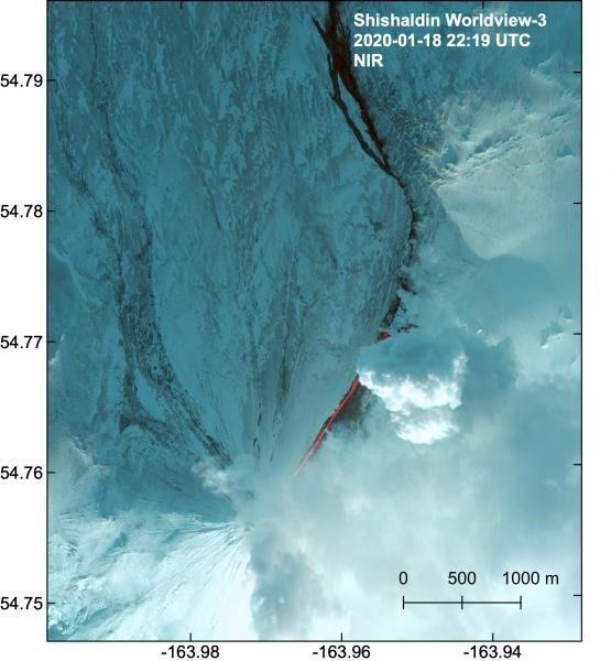 |
Figure 28. This Worldview-3 multispectral near-infrared satellite image acquired on 18 January 2020 shows a lava flow down the NE flank of Shishaldin. A steam plume rises from the end of the flow and lahar deposits from snowmelt travel further north. Courtesy of Matt Loewen, AVO. |
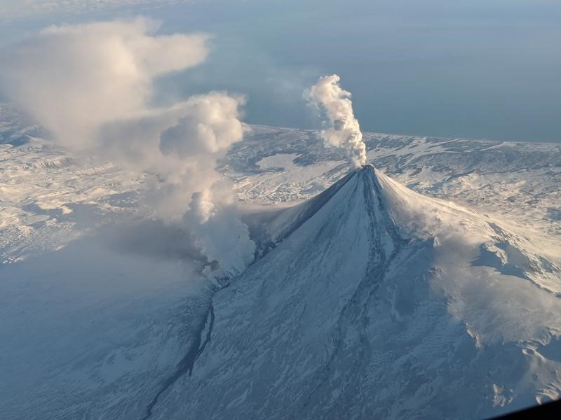 |
Figure 29. Steam plumes from the summit of Shishaldin and from the lava flow down the NE flank on 18 January 2020. Lahar deposits extend from the lava flow front and towards the north. Photo courtesy of Matt Brekke, via AVO. |
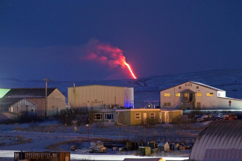 |
Figure 30. A lava flow traveling down the NE flank of Shishaldin on 18 January 2020, seen from Cold Bay. Photo courtesy of Aaron Merculief, via AVO. |
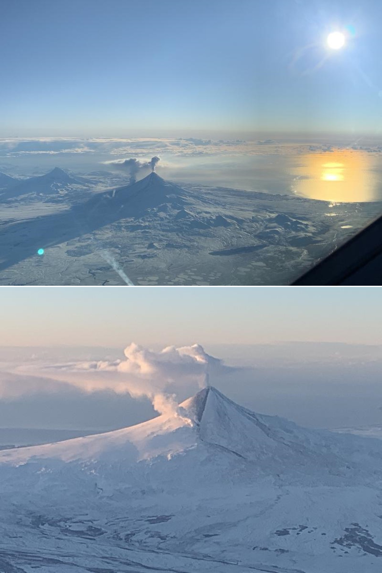 |
Figure 31. Two plumes rise from Shishaldin on 18 January 2020, one from the summit crater and the other from the lava flow descending the NE Flank. Photos courtesy of Woodsen Saunders, via AVO. |
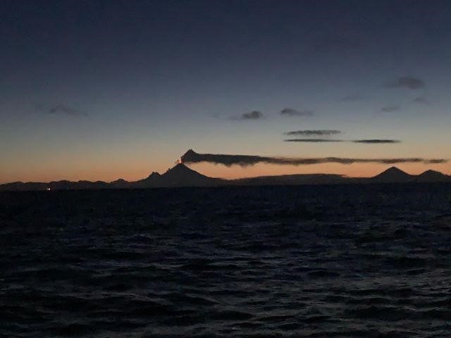 |
Figure 32. A low-altitude plume from Shishaldin on the evening of 18 January 2020, seen from King Cove. Photo courtesy of Savannah Yatchmeneff, via AVO. |
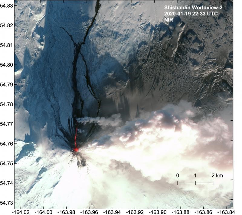 |
Figure 33. This WorldView-2 near-infrared satellite image shows a lava flow reaching 1.8 km down the N flank and lahar deposits filling drainages out to the Bering Sea coast (not shown here) on 19 January 2020. Ash deposits coat snow to the NE and E. Courtesy of Matt Loewen, AVO. |
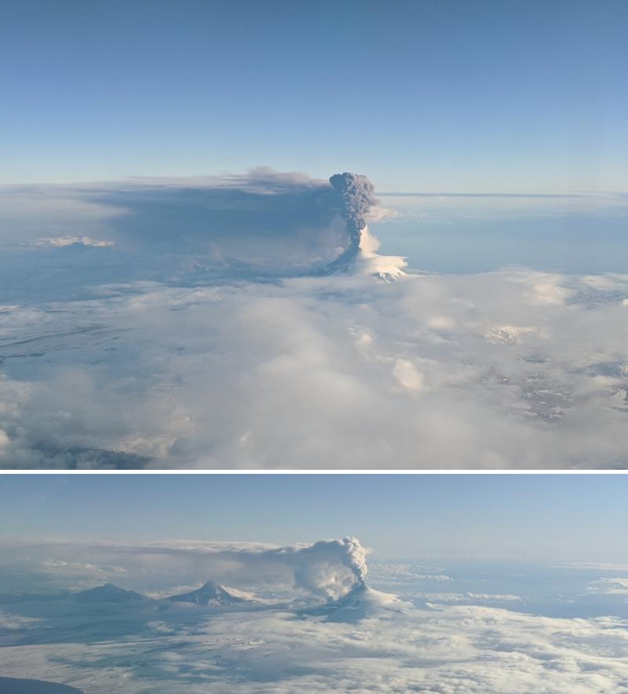 |
Figure 34. An ash plume (top) and gas-and-steam plumes (bottom) at Shishaldin on 19 January 2020. Courtesy of Matt Brekke, via AVO. |
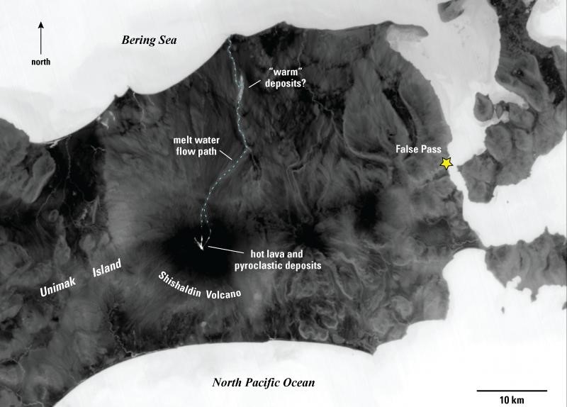 |
Figure 35. A Landsat 8 thermal satellite image (band 11) acquired on 23 January 2019 showing hot lava flows and pyroclastic flow deposits on the flanks of Shishaldin and the meltwater flow path to the Bering Sea. Figure courtesy of Christ Waythomas, AVO. |
Activity remained low in late January with some ash resuspension (due to winds) near the summit and continued elevated temperatures. Seismicity remained above background levels. Infrasound data indicated minor explosive activity during 22-23 January and small steam plumes were visible on 22, 23, and 26 January. MIROVA thermal data showed the rapid reduction in activity following activity in late-January (figure 36).
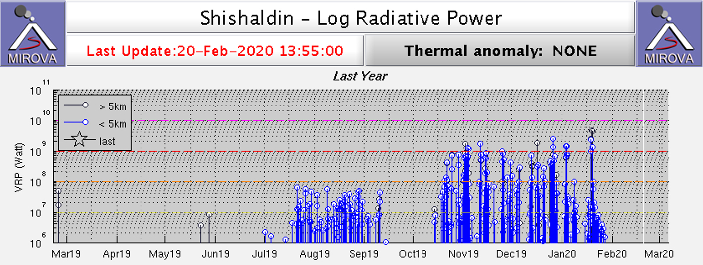 |
Figure 36. MIROVA thermal data showing increased activity at Shishaldin during August-September, and an even higher thermal output during late-October 2019 to late January 2020. Courtesy of MIROVA. |
Information Contacts: Alaska Volcano Observatory (AVO), a cooperative program of a) U.S. Geological Survey, 4200 University Drive, Anchorage, AK 99508-4667 USA (URL: https://avo.alaska.edu/), b) Geophysical Institute, University of Alaska, PO Box 757320, Fairbanks, AK 99775-7320, USA, and c) Alaska Division of Geological & Geophysical Surveys, 794 University Ave., Suite 200, Fairbanks, AK 99709, USA (URL: http://dggs.alaska.gov/); Simon Plank, German Aerospace Center (DLR) German Remote Sensing Data Center, Geo-Risks and Civil Security, Oberpfaffenhofen, 82234 Weßling (URL: https://www.dlr.de/eoc/en/desktopdefault.aspx/tabid-5242/8788_read-28554/sortby-lastname/); MIROVA (Middle InfraRed Observation of Volcanic Activity), a collaborative project between the Universities of Turin and Florence (Italy) supported by the Centre for Volcanic Risk of the Italian Civil Protection Department (URL: http://www.mirovaweb.it/); Planet Labs, Inc. (URL: https://www.planet.com/); Sentinel Hub Playground (URL: https://www.sentinel-hub.com/explore/sentinel-playground).
Intermittent thermal activity and a possible new cone at the summit crater during February-May 2020
Shishaldin is located near the center of Unimak Island in Alaska, with the current eruption phase beginning in July 2019 and characterized by ash plumes, lava flows, lava fountaining, pyroclastic flows, and lahars. More recently, in late 2019 and into January 2020, activity consisted of multiple lava flows, pyroclastic flows, lahars, and ashfall events (BGVN 45:02). This report summarizes activity from February through May 2020, including gas-and-steam emissions, brief thermal activity in mid-March, and a possible new cone within the summit crater. The primary source of information comes from the Alaska Volcano Observatory (AVO) reports and various satellite data.
Volcanism during February 2020 was relatively low, consisting of weakly to moderately elevated surface temperatures during 1-4 February and occasional small gas-and-steam plumes (figure 37). By 6 February both seismicity and surface temperatures had decreased. Seismicity and surface temperatures increased slightly again on 8 March and remained elevated through the rest of the reporting period. Intermittent gas-and-steam emissions were also visible from mid-March (figure 38) through May. Minor ash deposits visible on the upper SE flank may have been due to ash resuspension or a small collapse event at the summit, according to AVO.
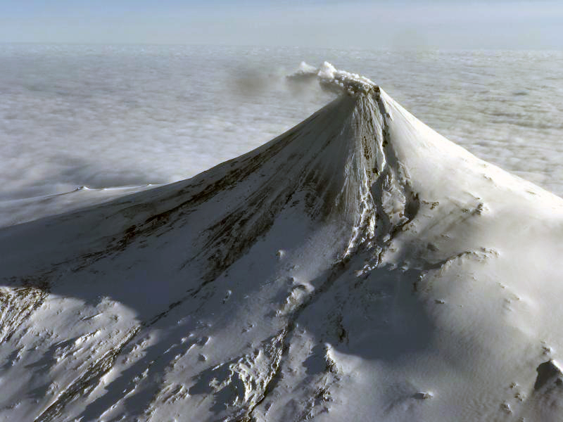 |
Figure 37. Photo of a gas-and-steam plume rising from the summit crater at Shishaldin on 22 February 2020. Photo courtesy of Ben David Jacob via AVO. |
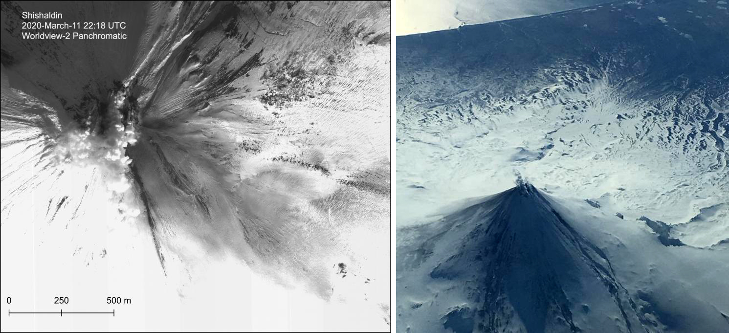 |
Figure 38. A Worldview-2 panchromatic satellite image on 11 March 2020 showing a gas-and-steam plume rising from the summit of Shishaldin and minor ash deposits on the SE flank (left). Aerial photo showing minor gas-and-steam emissions rising from the summit crater on 11 March (right). Some erosion of the snow and ice on the upper flanks is a result of the lava flows from the activity in late 2019 and early 2020. Photo courtesy of Matt Loewen (left) and Ed Fischer (right) via AVO. |
On 14 March, lava and a possible new cone were visible in the summit crater using satellite imagery, accompanied by small explosion signals. Strong thermal signatures due to the lava were also seen in Sentinel-2 satellite data and continued strongly through the month (figure 39). The lava reported by AVO in the summit crater was also reflected in satellite-based MODIS thermal anomalies recorded by the MIROVA system (figure 40). Seismic and infrasound data identified small explosions signals within the summit crater during 14-19 March.
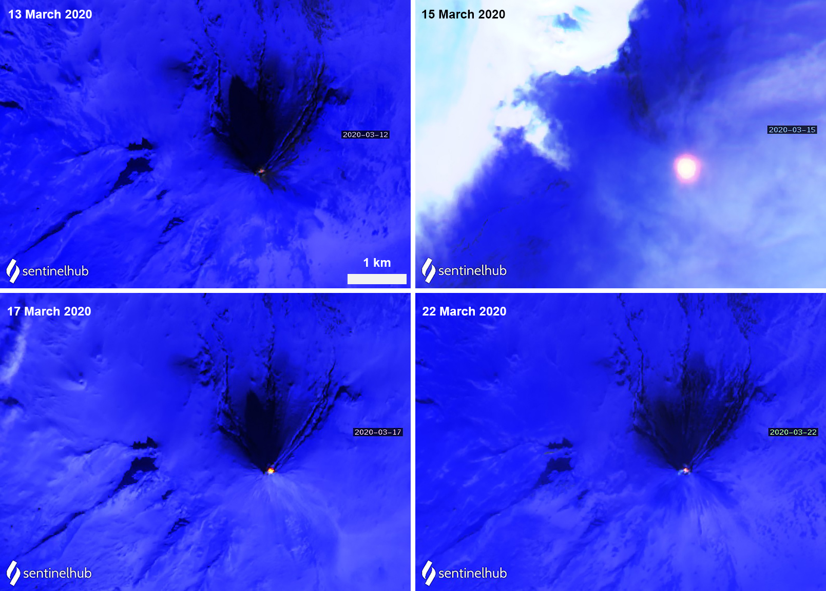 |
Figure 39. Sentinel-2 thermal satellite images (bands 12, 11, 8A) show a bright hotspot (yellow-orange) at the summit crater of Shishaldin during mid-March 2020 that decreases in intensity by late March. Courtesy of Sentinel Hub Playground. |
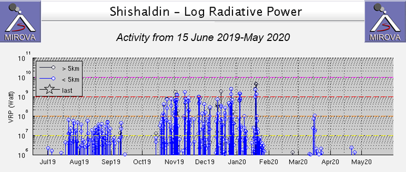 |
Figure 40. MIROVA thermal data showing a brief increase in thermal anomalies during late March 2020 and on two days in late April between periods of little to no activity. Courtesy of MIROVA. |
AVO released a Volcano Observatory Notice for Aviation (VONA) stating that seismicity had decreased by 16 April and that satellite data no longer showed lava or additional changes in the crater since the start of April. Sentinel-2 thermal satellite imagery continued to show a weak hotspot in the crater summit through May (figure 41), which was also detected by the MIROVA system on two days. A daily report on 6 May reported a visible ash deposit extending a short distance SE from the summit, which had likely been present since 29 April. AVO noted that the timing of the deposit corresponds to an increase in the summit crater diameter and depth, further supporting a possible small collapse. Small gas-and-steam emissions continued intermittently and were accompanied by weak tremors and occasional low-frequency earthquakes through May (figure 42). Minor amounts of sulfur dioxide were detected in the gas-and-steam emissions during 20 and 29 April, and 2, 16, and 28 May.
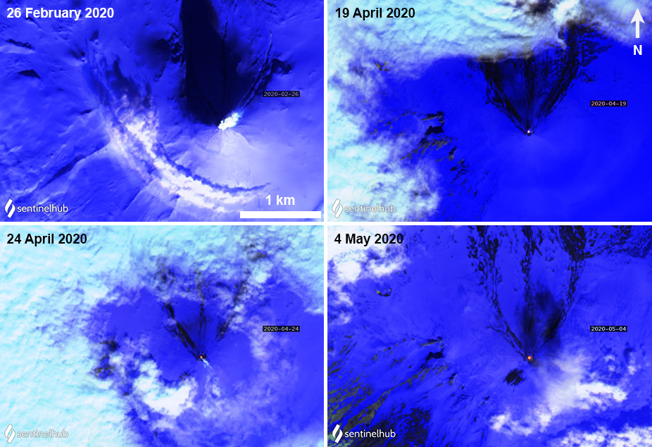 |
Figure 41. Sentinel-2 thermal satellite images (bands 12, 11, 8A) show occasional gas-and-steam emissions rising from Shishaldin on 26 February (top left) and 24 April 2020 (bottom left) and a weak hotspot (yellow-orange) persisting at the summit crater during April and early May 2020. Courtesy of Sentinel Hub Playground. |
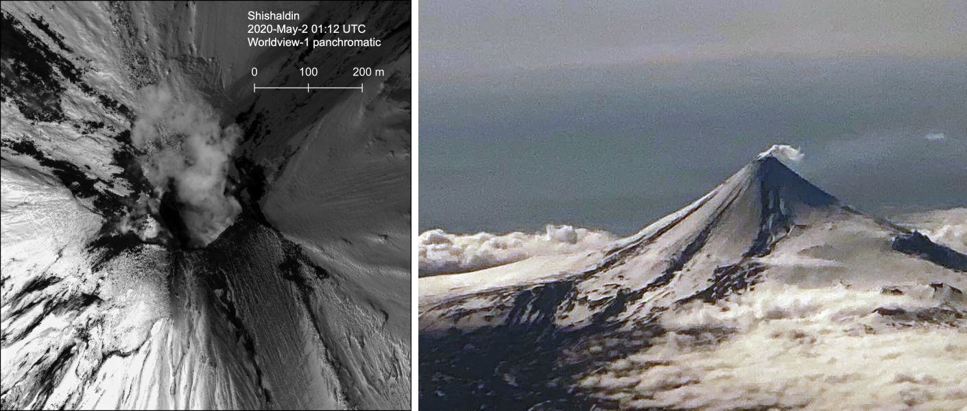 |
Figure 42. A Worldview-1 panchromatic satellite image showing gas-and-steam emissions rising from the summit of Shishaldin on 1 May 2020 (local time) (left). Aerial photo of the N flank of Shishaldin with minor gas-and-steam emissions rising from the summit on 8 May (right). Photo courtesy of Matt Loewen (left) and Levi Musselwhite (right) via AVO. |
Information Contacts: Alaska Volcano Observatory (AVO), a cooperative program of a) U.S. Geological Survey, 4200 University Drive, Anchorage, AK 99508-4667 USA (URL: https://avo.alaska.edu/), b) Geophysical Institute, University of Alaska, PO Box 757320, Fairbanks, AK 99775-7320, USA, and c) Alaska Division of Geological & Geophysical Surveys, 794 University Ave., Suite 200, Fairbanks, AK 99709, USA (URL: http://dggs.alaska.gov/); MIROVA (Middle InfraRed Observation of Volcanic Activity), a collaborative project between the Universities of Turin and Florence (Italy) supported by the Centre for Volcanic Risk of the Italian Civil Protection Department (URL: http://www.mirovaweb.it/); Sentinel Hub Playground (URL: https://www.sentinel-hub.com/explore/sentinel-playground).
New eruption with significant Strombolian explosions, ash plumes, and ashfall
Shishaldin is located on the eastern half of Unimak Island, one of the Aleutian Islands. Frequent explosive activity, primarily consisting of Strombolian ash eruptions from the small summit crater, but sometimes producing lava flows, has been recorded since the 18th century. The previous eruption ended in May 2020 and was characterized by intermittent thermal activity, increased seismicity and surface temperatures, ash plumes, and ash deposits (BGVN 45:06). This report covers a new eruption during July through November 2023, which consisted of significant explosions, ash plumes, ashfall, and lava fountaining. Information comes from daily, weekly, and special reports from the Alaska Volcano Observatory (AVO) and various satellite data. AVO monitors the volcano using local seismic and infrasound sensors, satellite data, web cameras, and remote infrasound and lightning networks.
AVO reported that intermittent tremor and low-frequency earthquakes had gradually become more regular and consistent during 10-13 July. Strongly elevated surface temperatures at the summit were identified in satellite images during 10-13 July. On 11 July AVO raised the Aviation Color Code (ACC) to Yellow (the second color on a four-color scale) and Volcano Alert Level (VAL) to Advisory (the second level on a four-level scale) at 1439. Later in the day on 11 July summit crater incandescence was observed in webcam images. Observations of the summit suggested that lava was likely present at the crater, which prompted AVO to raise the ACC to Orange (the second highest color on a four-color scale) and the VAL to Watch (the second highest level on a four-level scale). The US Coast Guard conducted an overflight on 12 July and confirmed that lava was erupting from the summit. That same day, sulfur dioxide emissions were detected in satellite images.
A significant explosion began at 0109 on 14 July that produced an ash plume that rose to 9-12 km altitude and drifted S over the Pacific Ocean (figure 43). Webcam images and photos taken around 0700 from a ship SW off Unimak Island showed small lahar deposits, which were the result of the interaction of hot pyroclastic material and snow and ice on the flanks. There was also ashfall on the SW and N flanks. A smaller explosion at 0710 generated an ash plume that rose to 4.5 km altitude. Webcam images and pilot reports showed continued low-level ash emissions during the morning, rising to less than 4.6 km altitude; those emissions included a small ash plume near the summit around 1030 resulting from a small explosion.
|
Figure 43. Photo of a strong ash plume that rose to 9-12 km altitude on the morning of 14 July 2023. Lahar deposits were visible on the SW flank (white arrows). Photo has been color corrected. Courtesy of Christopher Waythomas, AVO. |
Seismic tremor amplitude began increasing at around 1700 on 15 July; strongly elevated surface temperatures were also reported. An ash plume rose to 4.6 km altitude and drifted SSE at 2100, based on a satellite image. A continuous ash plume during 2150 through 2330 rose to 5 km altitude and extended 125 km S. At 2357 AVO raised the ACC to Red (the highest color on a four-color scale) and the VAL to Warning (the highest level on a four-level scale), noting that seismicity remained elevated for more than six hours and explosion signals were frequently detected by regional infrasound (pressure sensor) networks. Explosions generated an ash plume that rose to 4.9 km altitude and drifted as far as 500 km SE. Activity throughout the night declined and by 0735 the ACC was lowered to Orange and the VAL to Watch. High-resolution satellite images taken on 16 July showed pyroclastic deposits extending as far as 3 km from the vent; these deposits generated lahars that extended further down the drainages on the flanks. Ash deposits were mainly observed on the SSE flank and extended to the shore of Unimak Island. During 16-17 July lava continued to erupt at the summit, which caused strongly elevated surface temperatures that were visible in satellite imagery.
Lava effusion increased at 0100 on 18 July, as noted in elevated surface temperatures identified in satellite data, increasing seismic tremor, and activity detected on regional infrasound arrays. A significant ash plume at 0700 rose to 7 km altitude and continued until 0830, eventually reaching 9.1 km altitude and drifting SSE (figure 44). As a result, the ACC was raised to Red and the VAL to Warning. By 0930 the main plume detached, but residual low-level ash emissions continued for several hours, remaining below 3 km altitude and drifting S. The eruption gradually declined and by 1208 the ACC was lowered to Orange and the VAL was lowered to Watch. High-resolution satellite images showed ash deposits on the SW flank and pyroclastic deposits on the N, E, and S flanks, extending as far as 3 km from the vent; lahars triggered by the eruption extended farther down the flanks (figure 45). Lava continued to erupt from the summit crater on 19 July.
|
Figure 44. Photo of an ash-rich plume rising above Shishaldin to 9.1 km altitude on 18 July 2023 that drifted SE. View is from the N of the volcano and Isanotski volcano is visible on the left-hand side of the image. Photo has been color corrected. Courtesy of Chris Barnes, AVO. |
|
Figure 45. Near-infrared false-color satellite image of Shishaldin taken on 18 July 2023 showing ash deposits on the N, E, and S flanks extending as far as 3 km from the vent due to recent eruption events. Courtesy of Matthew Loewen, AVO. |
Elevated surface temperatures were detected in satellite images during 19-25 July, despite occasional weather cloud cover, which was consistent with increased lava effusion. During 22-23 July satellite observations acquired after the eruption from 18 July showed pyroclastic flow and lahar deposits extending as far as 3 km down the N, NW, and NE flanks and as far as 1.5 km down the S and SE flanks. Ash deposits covered the SW and NE flanks. No lava flows were observed outside the crater. On 22 July a sulfur dioxide plume was detected in satellite data midday that had an estimated mass of 10 kt. In a special notice issued at 1653 on 22 July AVO noted that eruptive activity had intensified over the previous six hours, which was characterized by an hours-long steady increase in seismic tremor, intermittent infrasound signals consistent with small explosions, and an increase in surface temperatures that were visible in satellite data. Pilots first reported low-level ash plumes at around 1900. At 2320 an ash plume had risen to 9 km altitude based on additional pilot reports and satellite images. The ACC was increased to Red and the VAL to Warning at 2343. Satellite images indicated growth of a significantly higher ash plume that rose to 11 km altitude continued until 0030 and drifted NE. During the early morning hours of 23 July ash plumes had declined to 4.6 k altitude. Seismic tremor peaked at 0030 on 23 July and began to rapidly decline at 0109; active ash emissions were no longer visible in satellite data by 0130. The ACC was lowered to Orange and the VAL to Watch at 0418; bursts of increased seismicity were recorded throughout the morning, but seismicity generally remained at low levels. Elevated surface temperatures were visible in satellite data until about 0600. On 24 July pilots reported seeing vigorous gas-and-steam plumes rising to about 3 km altitude; the plumes may have contained minor amounts of ash.
During 24-25 July low level seismicity and volcanic tremor were detected at low levels following the previous explosion on 23 July. Strongly elevated surface temperatures were observed at the summit crater in satellite data. Around 2200 on 25 July seismicity began to increase, followed by infrasound signals of explosions after 0200 on 26 July. An ash plume rose to 3 km altitude at 0500 and drifted ENE, along with an associated sulfur dioxide plume that drifted NE and had an estimated mass of 22 kt. Diffuse ash emissions were visible in satellite data and rose to 6.1-7.6 km altitude and extended 125 km from the volcano starting around 1130. These ash events were preceded by about seven hours of seismic tremor, infrasound detections of explosions, and five hours of increased surface temperatures visible in satellite data. Activity began to decline around 1327, which included low-frequency earthquakes and decreased volcanic tremor, and infrasound data no longer detected significant explosions. Surface temperatures remained elevated through the end of the month.
Seismicity, volcanic tremor, and ash emissions remained at low levels during early August. Satellite images on 1 August showed that some slumping had occurred on the E crater wall due to the recent explosive activity. Elevated surface temperatures continued, which was consistent with cooling lava. On 2 August small explosive events were detected, consistent with low-level Strombolian activity. Some episodes of volcanic tremor were reported, which reflected low-level ash emissions. Those ash emissions rose to less than 3 km altitude and drifted as far as 92.6 km N. Pilots that were located N of the volcano observed an ash plume that rose to 2.7 km altitude. Seismicity began to increase in intensity around 0900 on 3 August. Seismicity continued to increase throughout the day and through the night with strongly elevated surface temperatures, which suggested that lava was active at the surface.
An ash cloud that rose to 7.6-7.9 km altitude and drifted 60-75 km NE was visible in a satellite image at 0520 on 4 August. Pilots saw and reported the plume at 0836 (figure 46). By 0900 the plume had risen to 9.1 km altitude and extended over 100 km NE. AVO raised the ACC to Red and the VAL to Warning as a result. Seismic tremor levels peaked at 1400 and then sharply declined at 1500 to slightly elevated levels; the plume was sustained during the period of high tremor and drifted N and NE. The ACC was lowered to Orange and the VAL to Watch at 2055. During 5-14 August seismicity remained low and surface temperatures were elevated based on satellite data due to cooling lava. On 9 August a small lava flow was observed that extended from the crater rim to the upper NE flank. It had advanced to 55 m in length and appeared in satellite imagery on 11 August. Occasional gas-and-steam plumes were noted in webcam images. At 1827 AVO noted that seismic tremor had steadily increased during the afternoon and erupting lava was visible at the summit in satellite images.
|
Figure 46. Photo showing an ash plume rising above Shishaldin during the morning of 4 August 2023 taken by a passing aircraft. The view is from the N showing a higher gas-rich plume and a lower gray ash-rich plume and dark tephra deposits on the volcano’s flank. Photo has been color corrected. Courtesy of Chris Barnes, AVO. |
Strong explosion signals were detected at 0200 on 15 August. An ash cloud that was visible in satellite data extended 100 km NE and may have risen as high as 11 km altitude around 0240. By 0335 satellite images showed the ash cloud rising to 7.6 km altitude and drifting NE. Significant seismicity and explosions were detected by the local AVO seismic and infrasound networks, and volcanic lightning was detected by the World Wide Lightning Location Network (WWLLN). A sulfur dioxide plume associated with the eruption drifted over the S Bering Sea and parts of Alaska and western Canada. Seismicity was significantly elevated during the eruption but had declined by 1322. A pilot reported that ash emissions continued, rising as high as 4.9 km altitude. Elevated surface temperatures detected in satellite data were caused by hot, eruptive material (pyroclastic debris and lava) that accumulated around the summit. Eruptive activity declined by 16 August and the associated sulfur dioxide plume had mostly dissipated; remnants continued to be identified in satellite images at least through 18 August. Surface temperatures remained elevated based on satellite images, indicating hot material on the upper parts of the volcano. Small explosions were detected in infrasound data on the morning of 19 August and were consistent with pilot reports of small, short-lived ash plumes that rose to about 4.3 km altitude. Low-level explosive activity was reported during 20-24 August, according to seismic and infrasound data, and weather clouds sometimes prevented views. Elevated surface temperatures were observed in satellite images, which indicated continued hot material on the upper parts of the volcano.
Seismic tremor began to increase at around 0300 on 25 August and was followed by elevated surface temperatures identified in satellite images, consistent with erupting lava. Small explosions were recorded in infrasound data. The ACC was raised to Red and the VAL to Warning at 1204 after a pilot reported an ash plume that rose to 9.1 km altitude. Seismicity peaked at 1630 and began to rapidly decline at around 1730. Ash plumes rose as high as 10 km altitude and drifted as far as 400 km NE. By 2020 the ash plumes had declined to 6.4 km altitude and continued to drift NE. Ash emissions were visible in satellite data until 0000 on 26 August and seismicity was at low levels. AVO lowered the ACC to Orange and the VAL to Watch at 0030. Minor explosive activity within the summit crater was detected during 26-28 August and strongly elevated surface temperatures were still visible in satellite imagery through the rest of the month. An AVO field crew working on Unimak Island observed a mass flow that descended the upper flanks beginning around 1720 on 27 August. The flow produced a short-lived ash cloud that rose to 4.5 km altitude and rapidly dissipated. The mass flow was likely caused by the collapse of spatter that accumulated on the summit crater rim.
Similar variable explosive activity was reported in September, although weather observations sometimes prevented observations. A moderate resolution satellite image from the afternoon of 1 September showed gas-and-steam emissions filling the summit crater and obscuring views of the vent. In addition, hot deposits from the previous 25-26 August explosive event were visible on the NE flank near the summit, based on a 1 September satellite image. On 2 and 4 September seismic and infrasound data showed signals of small, repetitive explosions. Variable gas-and-steam emissions from the summit were visible but there was no evidence of ash. Possible summit crater incandescence was visible in nighttime webcam images during 3-4 September.
Seismicity began to gradually increase at around 0300 on 5 September and activity escalated at around 0830. A pilot reported an ash plume that rose to 7.6 km altitude at 0842 and continued to rise as high as possibly 9.7 km altitude and drifted SSE based on satellite images (figure 47). The ACC was raised to Red and the VAL to Warning at 0900. In addition to strong tremor and sustained explosions, the eruption produced volcanic lightning that was detected by the WWLLN. Around 1100 seismicity decreased and satellite data confirmed that the altitude of the ash emissions had declined to 7.6 km altitude. By 1200 the lower-altitude portion of the ash plume had drifted 125 km E. Significant ash emissions ended by 1330 based on webcam images. The ACC was lowered to Orange and the VAL to Watch at 1440. Satellite images showed extensive pyroclastic debris flows on most of the flanks that extended 1.2-3.3 km from the crater rim.
|
Figure 47. Webcam image taken from the S of Shishaldin showing a vertical ash plume on 5 September 2023. Courtesy of AVO. |
During 6-13 September elevated surface temperatures continued to be observed in satellite data, seismicity remained elevated with weak but steady tremor, and small, low-frequency earthquakes and small explosions were reported, except on 12 September. On 6 September a low-level ash plume rose to 1.5-1.8 km altitude and drifted SSE. Occasional small and diffuse gas-and-steam emissions at the summit were visible in webcam images. Around 1800 on 13 September seismic tremor amplitudes began to increase, and small explosions were detected in seismic and infrasound data. Incandescent lava at the summit was seen in a webcam image taken at 0134 on 14 September during a period of elevated tremor. No ash emissions were reported during the period of elevated seismicity. Lava fountaining began around 0200, based on webcam images. Satellite-based radar observations showed that the lava fountaining activity led to the growth of a cone in the summit crater, which refilled most of the crater. By 0730 seismicity significantly declined and remained at low levels.
Seismic tremor began to increase around 0900 on 15 September and rapidly intensified. An explosive eruption began at around 1710, which prompted AVO to raise the ACC to Red and the VAL to Warning. Within about 30 minutes ash plumes drifted E below a weather cloud at 8.2 km altitude. The National Weather Service estimated that an ash-rich plume rose as high as 12.8 km altitude and produced volcanic lightning. The upper part of the ash plume detached from the vent around 1830 and drifted E, and was observed over the Gulf of Alaska. Around the same time, seismicity dramatically decreased. Trace ashfall was reported in the community of False Pass (38 km ENE) between 1800-2030 and also in King Cove and nearby marine waters. Activity declined at around 1830 although seismicity remained elevated, ash emissions, and ashfall continued until 2100. Lightning was again detected beginning around 1930, which suggested that ash emissions continued. Ongoing explosions were detected in infrasound data, at a lower level than during the most energetic phase of this event. Lightning was last detected at 2048. By 2124 the intensity of the eruption had decreased, and ash emissions were likely rising to less than 6.7 km altitude. Seismicity returned to pre-eruption levels. On 16 September the ACC was lowered to Orange and the VAL to Watch at 1244; the sulfur dioxide plume that was emitted from the previous eruption event was still visible over the northern Pacific Ocean. Elevated surface temperatures, gas-and-steam emissions from the vent, and new, small lahars were reported on the upper flanks based on satellite and webcam images. Minor deposits were reported on the flanks which were likely the result of collapse of previously accumulated lava near the summit crater.
Elevated seismicity with tremor, small earthquakes, and elevated surface temperatures were detected during 17-23 September. Minor gas-and-steam emissions were visible in webcam images. On 20 September small volcanic debris flows were reported on the upper flanks. On 21 September a small ash deposit was observed on the upper flanks extending to the NE based on webcam images. Seismic tremor increased significantly during 22-23 September. Regional infrasound sensors suggested that low-level eruptive activity was occurring within the summit crater by around 1800 on 23 September. Even though seismicity was at high levels, strongly elevated surface temperatures indicating lava at the surface were absent and no ash emissions were detected; weather clouds at 0.6-4.6 km altitude obscured views. At 0025 on 24 September AVO noted that seismicity continued at high levels and nearly continuous small infrasound signals began, likely from low-level eruptive activity. Strongly elevated surface temperatures were identified in satellite images by 0900 and persisted throughout the day; the higher temperatures along with infrasound and seismic data were consistent with lava erupting at the summit. Around 1700 similarly elevated surface temperatures were detected from the summit in satellite data, which suggested that more vigorous lava fountaining had started. Starting around 1800 low-level ash emissions rose to altitudes less than 4.6 km altitude and quickly dissipated.
Beginning at midnight on 25 September, a series of seismic signals consistent with volcanic flows were recorded on the N side of the volcano. A change in seismicity and infrasound signals occurred around 0535 and at 0540 a significant ash cloud formed and quickly reached 14 km altitude and drifted E along the Alaska Peninsula. The cloud generated at least 150 lightning strokes with thunder that could be heard by people in False Pass. Seismicity rapidly declined to near background levels around 0600. AVO increased the ACC to Red and the VAL to Warning at 0602. The ash cloud detached from the volcano at around 0700, rose to 11.6 km altitude, and drifted ESE. Trace to minor amounts of ashfall were reported by the communities of False Pass, King Cove, Cold Bay, and Sand Point around 0700. Ash emissions continued at lower altitudes of 6-7.6 km altitude at 0820. Small explosions at the vent area continued to be detected in infrasound data and likely represented low-level eruptive activity near the vent. Due to the significant decrease in seismicity and ash emissions the ACC was lowered to Orange and the VAL to Watch at 1234. Radar data showed significant collapses of the crater that occurred on 25 September. Satellite data also showed significant hot, degassing pyroclastic and lahar deposits on all flanks, including more extensive flows on the ENE and WSW sections below two new collapse scarps. Following the significant activity during 24-25 September, only low-level activity was observed. Seismicity decreased notably near the end of the strong activity on 25 September and continued to decrease through the end of the month, though tremor and small earthquakes were still reported. No explosive activity was detected in infrasound data through 2 October. Gas-and-steam emissions rose to 3.7 km altitude, as reported by pilots and seen in satellite images. Satellite data from 26 September showed that significant collapses had occurred at the summit crater and hot, steaming deposits from pyroclastic flows and lahars were present on all the flanks, particularly to the ENE and WSW. A small ash cloud was visible in webcam images on 27 September, likely from a collapse at the summit cone. High elevated surface temperatures were observed in satellite imagery during 27-28 September, which were likely the result of hot deposits on the flanks erupted on 25 September. Minor steaming at the summit crater and from an area on the upper flanks was visible in webcam images on 28 September.
During October, explosion events continued between periods of low activity. Seismicity significantly increased starting at around 2100 on 2 October; around the same time satellite images showed an increase in surface temperatures consistent with lava fountaining. Small, hot avalanches of rock and lava descended an unspecified flank. In addition, a distinct increase in infrasound, seismicity, and lightning detections was followed by an ash plume that rose to 12.2 km altitude and drifted S and E at 0520 on 3 October, based on satellite images. Nighttime webcam images showed incandescence due to lava fountaining at the summit and pyroclastic flows descending the NE flank. AVO reported that a notable explosive eruption started at 0547 and lasted until 0900 on 3 October, which prompted a rise in the ACC to Red and the VAL to Warning. Subsequent ash plumes rose to 6-7.6 km altitude by 0931. At 1036 the ACC was lowered back to Orange and the VAL to Watch since both seismic and infrasound data quieted substantially and were slightly above background levels. Gas-and-steam emissions were observed at the summit, based on webcam images. Trace amounts of ashfall were observed in Cold Bay. Resuspended ash was present at several kilometers altitude near the volcano. During the afternoon, low-level ash plumes were visible at the flanks, which appeared to be largely generated by rock avalanches off the summit crater following the explosive activity. These ash plumes rose to 3 km altitude and drifted W. Trace amounts of ashfall were reported by observers in Cold Bay and Unalaska and flights to these communities were disrupted by the ash cloud. Satellite images taken after the eruption showed evidence of pyroclastic flows and lahar deposits in drainages 2 km down the SW flank and about 3.2 km down the NE flank, and continued erosion of the crater rim. Small explosion craters at the end of the pyroclastic flows on the NE flank were noted for the first time, which may have resulted from gas-and-steam explosions when hot deposits interact with underlying ice.
During 4 October seismicity, including frequent small earthquakes, remained elevated, but was gradually declining. Ash plumes were produced for over eight hours until around 1400 that rose to below 3.7 km altitude. These ash plumes were primarily generated off the sides of the volcano where hot rock avalanches from the crater rim had entered drainages to the SW and NE. Two explosion craters were observed at the base of the NE deposits about 3.2 km from the crater rim. Webcam images showed the explosion craters were a source of persistent ash emissions; occasional collapse events also generated ash. Seismicity remained elevated with sulfur dioxide emissions that had a daily average of more than 1,000 tons per day, and frequent small earthquakes through the end of the month. Frequent elevated surface temperatures were identified in satellite images and gas-and-steam plumes were observed in webcam images, although weather conditions occasionally prevented clear views of the summit. Emissions were robust during 14-16 October and were likely generated by the interaction of hot material and snow and ice. During the afternoon of 21 October a strong gas-and-steam plume rose to 3-4.6 km altitude and extended 40 km WSW, based on satellite images and reports from pilots. On 31 October the ACC was lowered to Yellow and the VAL was lowered to Advisory.
Activity in November was characterized by elevated seismicity with ongoing seismic tremor and small, low-frequency earthquakes, elevated surface temperatures, and gas-and-steam emissions. There was an increase in seismic and infrasound tremor amplitudes starting at 1940 on 2 November. As a result, the ACC was again raised to Orange and the VAL was increased to Watch, although ash was not identified in satellite data. An ash cloud rose to 6.1 km altitude and drifted W according to satellite data at 2000. By 0831 on 3 November ash emissions were no longer visible in satellite images. On 6 and 9 November air pressure sensors detected signals consistent with small explosions. Small explosions were detected in infrasound data consistent with weak Strombolian activity on 19 and 21 November. Seismicity started to decrease on 21 November. On 25 November gas-and-steam emissions were emitted from the vent as well as from a scarp on the NE side of the volcano near the summit. A gas-and-steam plume extended about 50 km SSE and was observed in satellite and webcam images on 26 November. On 28 November small explosions were observed in seismic and local infrasound data and gas-and-steam emissions were visible from the summit and from the upper NE collapse scarp based on webcam images. Possible small explosions were observed in infrasound data on 30 November. Weakly elevated surface temperatures and a persistent gas-and-steam plume from the summit and collapse scarps on the upper flanks. A passing aircraft reported the gas-and-steam plume rose to 3-3.4 km altitude on 30 November, but no significant ash emissions were detected.
Satellite data. MODIS thermal anomaly data provided through MIROVA (Middle InfraRed Observation of Volcanic Activity) showed a strong pulse of thermal activity beginning in July 2023 that continued through November 2023 (figure 48). This strong activity was due to Strombolian explosions and lava fountaining events at the summit crater. According to data from MODVOLC thermal alerts, a total of 101 hotspots were detected near the summit crater in July (11-14, 16-19, 23-24 and 26), August (4, 25-26, and 29), September (5, 12, and 17), and October (3, 4, and 8). Infrared satellite data showed large lava flows descending primarily the northern and SE flanks during the reporting period (figure 49). Sulfur dioxide plumes often exceeded two Dobson Units (DUs) and drifted in different directions throughout the reporting period, based on satellite data from the TROPOMI instrument on the Sentinel-5P satellite (figure 50).
|
Figure 48. Graph of Landsat 8 and 9 OLI thermal data from 1 June 2024 showing a strong surge in thermal activity during July through November 2023. During mid-October, the intensity of the hotspots gradually declined. Courtesy of MIROVA. |
|
Figure 49. Infrared (bands B12, B11, B4) satellite images show several strong lava flows (bright yellow-orange) affecting the northern and SE flanks of Shishaldin on 18 July 2023 (top left), 4 June 2023 (top right), 26 September 2023 (bottom left), and 3 October 2023 (bottom right). Courtesy of Copernicus Browser. |
|
Figure 50. Strong sulfur dioxide plumes were detected at Shishaldin and drifted in different directions on 15 August 2023 (top left), 5 September 2023 (top right), 25 September 2023 (bottom left), and 6 October 2023 (bottom right). Courtesy of NASA Global Sulfur Dioxide Monitoring Page. |
Information Contacts: Alaska Volcano Observatory (AVO), a cooperative program of a) U.S. Geological Survey, 4200 University Drive, Anchorage, AK 99508-4667 USA (URL: https://avo.alaska.edu/), b) Geophysical Institute, University of Alaska, PO Box 757320, Fairbanks, AK 99775-7320, USA, and c) Alaska Division of Geological & Geophysical Surveys, 794 University Ave., Suite 200, Fairbanks, AK 99709, USA (URL: http://dggs.alaska.gov/); MIROVA (Middle InfraRed Observation of Volcanic Activity), a collaborative project between the Universities of Turin and Florence (Italy) supported by the Centre for Volcanic Risk of the Italian Civil Protection Department (URL: http://www.mirovaweb.it/); Hawai'i Institute of Geophysics and Planetology (HIGP) - MODVOLC Thermal Alerts System, School of Ocean and Earth Science and Technology (SOEST), Univ. of Hawai'i, 2525 Correa Road, Honolulu, HI 96822, USA (URL: http://modis.higp.hawaii.edu/); NASA Global Sulfur Dioxide Monitoring Page, Atmospheric Chemistry and Dynamics Laboratory, NASA Goddard Space Flight Center (NASA/GSFC), 8800 Greenbelt Road, Goddard, Maryland, USA (URL: https://so2.gsfc.nasa.gov/); Copernicus Browser, Copernicus Data Space Ecosystem, European Space Agency (URL: https://dataspace.copernicus.eu/browser/).
|
|
||||||||||||||||||||||||||||
There is data available for 40 confirmed eruptive periods.
2023 Jul 11 ± 1 days - 2023 Nov 3 Confirmed Eruption (Explosive / Effusive) VEI: 3
| Episode 1 | Eruption (Explosive / Effusive) | |||||||||||||||||||||||||||||||||||||||||||||||||
|---|---|---|---|---|---|---|---|---|---|---|---|---|---|---|---|---|---|---|---|---|---|---|---|---|---|---|---|---|---|---|---|---|---|---|---|---|---|---|---|---|---|---|---|---|---|---|---|---|---|
| 2023 Jul 11 ± 1 days - 2023 Nov 3 | Evidence from Observations: Reported | ||||||||||||||||||||||||||||||||||||||||||||||||
|
List of 8 Events for Episode 1
|
|||||||||||||||||||||||||||||||||||||||||||||||||
2019 Jul 23 - 2020 May 4 Confirmed Eruption (Explosive / Effusive) VEI: 3
| Episode 1 | Eruption (Explosive / Effusive) | Summit crater | |||||||||||||||||||||||||||||||||||||||||||
|---|---|---|---|---|---|---|---|---|---|---|---|---|---|---|---|---|---|---|---|---|---|---|---|---|---|---|---|---|---|---|---|---|---|---|---|---|---|---|---|---|---|---|---|---|
| 2019 Jul 23 - 2020 May 4 | Evidence from Observations: Reported | |||||||||||||||||||||||||||||||||||||||||||
|
List of 7 Events for Episode 1 at Summit crater
|
||||||||||||||||||||||||||||||||||||||||||||
2014 Jan 30 - 2015 Jul 3 Confirmed Eruption (Explosive / Effusive) VEI: 1
| Episode 1 | Eruption (Explosive / Effusive) | Summit crater | |||||||||||||||||||||||||||||||||||||||||||||||||||||||||||||||||||||||||||||||||||||||||||||||||||||||||||||||||||||||||||||||||||||||||||||||||||||||||||||||||||||||||||||||||||||||||||||||||||||||||||||||||||||||||||||||||||||||||||||||||||||||||||||||||||||||||||||||||||||||||||||||||||||||||||||||||||||||||||||||||||||||||||||||||||||||||||||||||||||||||||||||||||||||||||||||||||||||||||||||||||||||||||||||||||||||||||||||||||||||||||||||||||||||||||||||
|---|---|---|---|---|---|---|---|---|---|---|---|---|---|---|---|---|---|---|---|---|---|---|---|---|---|---|---|---|---|---|---|---|---|---|---|---|---|---|---|---|---|---|---|---|---|---|---|---|---|---|---|---|---|---|---|---|---|---|---|---|---|---|---|---|---|---|---|---|---|---|---|---|---|---|---|---|---|---|---|---|---|---|---|---|---|---|---|---|---|---|---|---|---|---|---|---|---|---|---|---|---|---|---|---|---|---|---|---|---|---|---|---|---|---|---|---|---|---|---|---|---|---|---|---|---|---|---|---|---|---|---|---|---|---|---|---|---|---|---|---|---|---|---|---|---|---|---|---|---|---|---|---|---|---|---|---|---|---|---|---|---|---|---|---|---|---|---|---|---|---|---|---|---|---|---|---|---|---|---|---|---|---|---|---|---|---|---|---|---|---|---|---|---|---|---|---|---|---|---|---|---|---|---|---|---|---|---|---|---|---|---|---|---|---|---|---|---|---|---|---|---|---|---|---|---|---|---|---|---|---|---|---|---|---|---|---|---|---|---|---|---|---|---|---|---|---|---|---|---|---|---|---|---|---|---|---|---|---|---|---|---|---|---|---|---|---|---|---|---|---|---|---|---|---|---|---|---|---|---|---|---|---|---|---|---|---|---|---|---|---|---|---|---|---|---|---|---|---|---|---|---|---|---|---|---|---|---|---|---|---|---|---|---|---|---|---|---|---|---|---|---|---|---|---|---|---|---|---|---|---|---|---|---|---|---|---|---|---|---|---|---|---|---|---|---|---|---|---|---|---|---|---|---|---|---|---|---|---|---|---|---|---|---|---|---|---|---|---|---|---|---|---|---|---|---|---|---|---|---|---|---|---|---|---|---|---|---|---|---|---|---|---|---|---|---|---|---|---|---|---|---|---|---|---|---|---|---|---|---|---|---|---|---|---|---|---|---|---|---|---|---|---|---|---|---|---|---|---|---|---|---|---|---|---|---|---|---|---|---|---|---|---|---|---|---|---|---|---|---|---|---|---|---|---|---|---|---|---|---|---|---|---|---|---|
| 2014 Jan 30 - 2015 Jul 3 | Evidence from Observations: Reported | |||||||||||||||||||||||||||||||||||||||||||||||||||||||||||||||||||||||||||||||||||||||||||||||||||||||||||||||||||||||||||||||||||||||||||||||||||||||||||||||||||||||||||||||||||||||||||||||||||||||||||||||||||||||||||||||||||||||||||||||||||||||||||||||||||||||||||||||||||||||||||||||||||||||||||||||||||||||||||||||||||||||||||||||||||||||||||||||||||||||||||||||||||||||||||||||||||||||||||||||||||||||||||||||||||||||||||||||||||||||||||||||||||||||||||||||
|
List of 91 Events for Episode 1 at Summit crater
|
||||||||||||||||||||||||||||||||||||||||||||||||||||||||||||||||||||||||||||||||||||||||||||||||||||||||||||||||||||||||||||||||||||||||||||||||||||||||||||||||||||||||||||||||||||||||||||||||||||||||||||||||||||||||||||||||||||||||||||||||||||||||||||||||||||||||||||||||||||||||||||||||||||||||||||||||||||||||||||||||||||||||||||||||||||||||||||||||||||||||||||||||||||||||||||||||||||||||||||||||||||||||||||||||||||||||||||||||||||||||||||||||||||||||||||||||
[ 2008 Feb 12 - 2008 Feb 12 ] Uncertain Eruption
| Episode 1 | Eruption (Explosive / Effusive) | ||||||||||||||||||||||||
|---|---|---|---|---|---|---|---|---|---|---|---|---|---|---|---|---|---|---|---|---|---|---|---|---|
| 2008 Feb 12 - 2008 Feb 12 | Evidence from Unknown | |||||||||||||||||||||||
|
List of 3 Events for Episode 1
|
||||||||||||||||||||||||
2004 Feb 17 - 2004 Jul 16 (on or after) ± 15 days Confirmed Eruption (Explosive / Effusive) VEI: 2
| Episode 1 | Eruption (Explosive / Effusive) | |||||||||||||||||||||||||||||||||||||||
|---|---|---|---|---|---|---|---|---|---|---|---|---|---|---|---|---|---|---|---|---|---|---|---|---|---|---|---|---|---|---|---|---|---|---|---|---|---|---|---|
| 2004 Feb 17 - 2004 Jul 16 (on or after) ± 15 days | Evidence from Observations: Reported | ||||||||||||||||||||||||||||||||||||||
|
List of 6 Events for Episode 1
|
|||||||||||||||||||||||||||||||||||||||
[ 2000 Aug 11 ] Uncertain Eruption
| Episode 1 | Eruption (Explosive / Effusive) | Summit | |||||||||||||||||||||||
|---|---|---|---|---|---|---|---|---|---|---|---|---|---|---|---|---|---|---|---|---|---|---|---|---|
| 2000 Aug 11 - Unknown | Evidence from Unknown | |||||||||||||||||||||||
|
List of 3 Events for Episode 1 at Summit
|
||||||||||||||||||||||||
[ 1999 Sep 25 ± 5 days - 2000 Feb 4 (?) ] Uncertain Eruption
| Episode 1 | Eruption (Explosive / Effusive) | ||||||||||||||||||||||||
|---|---|---|---|---|---|---|---|---|---|---|---|---|---|---|---|---|---|---|---|---|---|---|---|---|
| 1999 Sep 25 ± 5 days - 2000 Feb 4 (?) | Evidence from Unknown | |||||||||||||||||||||||
|
List of 3 Events for Episode 1
|
||||||||||||||||||||||||
1999 Mar 13 - 1999 May 27 Confirmed Eruption (Explosive / Effusive) VEI: 3
| Episode 1 | Eruption (Explosive / Effusive) | ||||||||||||||||||||||||||||||||||||||||||||||||||||||||||||||||
|---|---|---|---|---|---|---|---|---|---|---|---|---|---|---|---|---|---|---|---|---|---|---|---|---|---|---|---|---|---|---|---|---|---|---|---|---|---|---|---|---|---|---|---|---|---|---|---|---|---|---|---|---|---|---|---|---|---|---|---|---|---|---|---|---|
| 1999 Mar 13 - 1999 May 27 | Evidence from Observations: Reported | |||||||||||||||||||||||||||||||||||||||||||||||||||||||||||||||
|
List of 11 Events for Episode 1
|
||||||||||||||||||||||||||||||||||||||||||||||||||||||||||||||||
1998 Nov 4 - 1998 Nov 4 Confirmed Eruption (Explosive / Effusive) VEI: 1
| Episode 1 | Eruption (Explosive / Effusive) | ||||||||||||||||||||||||
|---|---|---|---|---|---|---|---|---|---|---|---|---|---|---|---|---|---|---|---|---|---|---|---|---|
| 1998 Nov 4 - 1998 Nov 4 | Evidence from Observations: Reported | |||||||||||||||||||||||
|
List of 3 Events for Episode 1
|
||||||||||||||||||||||||
1997 Jun 2 - 1997 Jun 2 Confirmed Eruption (Explosive / Effusive) VEI: 1
| Episode 1 | Eruption (Explosive / Effusive) | ||||||||||||||||||||||||
|---|---|---|---|---|---|---|---|---|---|---|---|---|---|---|---|---|---|---|---|---|---|---|---|---|
| 1997 Jun 2 - 1997 Jun 2 | Evidence from Observations: Reported | |||||||||||||||||||||||
|
List of 3 Events for Episode 1
|
||||||||||||||||||||||||
1995 Dec 23 - 1996 May 16 (on or before) Confirmed Eruption (Explosive / Effusive) VEI: 3
| Episode 1 | Eruption (Explosive / Effusive) | ||||||||||||||||||||||||
|---|---|---|---|---|---|---|---|---|---|---|---|---|---|---|---|---|---|---|---|---|---|---|---|---|
| 1995 Dec 23 - 1996 May 16 (on or before) | Evidence from Observations: Reported | |||||||||||||||||||||||
|
List of 3 Events for Episode 1
|
||||||||||||||||||||||||
1993 Sep 4 - 1993 Oct 29 Confirmed Eruption (Explosive / Effusive) VEI: 2
| Episode 1 | Eruption (Explosive / Effusive) | |||||||||||||||||||||||||||||
|---|---|---|---|---|---|---|---|---|---|---|---|---|---|---|---|---|---|---|---|---|---|---|---|---|---|---|---|---|---|
| 1993 Sep 4 - 1993 Oct 29 | Evidence from Observations: Reported | ||||||||||||||||||||||||||||
|
List of 4 Events for Episode 1
|
|||||||||||||||||||||||||||||
1986 Mar 19 - 1987 Feb 15 (?) Confirmed Eruption (Explosive / Effusive) VEI: 2
| Episode 1 | Eruption (Explosive / Effusive) | ||||||||||||||||||||||||
|---|---|---|---|---|---|---|---|---|---|---|---|---|---|---|---|---|---|---|---|---|---|---|---|---|
| 1986 Mar 19 - 1987 Feb 15 (?) | Evidence from Observations: Reported | |||||||||||||||||||||||
|
List of 3 Events for Episode 1
|
||||||||||||||||||||||||
[ 1981 Sep 25 ] Uncertain Eruption
| Episode 1 | Eruption (Explosive / Effusive) | ||||||||||||||
|---|---|---|---|---|---|---|---|---|---|---|---|---|---|---|
| 1981 Sep 25 - Unknown | Evidence from Unknown | |||||||||||||
|
List of 1 Events for Episode 1
|
||||||||||||||
1979 Feb 16 ± 15 days Confirmed Eruption (Explosive / Effusive) VEI: 2
| Episode 1 | Eruption (Explosive / Effusive) | ||||||||||||||||||||||||
|---|---|---|---|---|---|---|---|---|---|---|---|---|---|---|---|---|---|---|---|---|---|---|---|---|
| 1979 Feb 16 ± 15 days - Unknown | Evidence from Observations: Reported | |||||||||||||||||||||||
|
List of 3 Events for Episode 1
|
||||||||||||||||||||||||
1978 Feb 8 - 1978 Feb 9 (?) Confirmed Eruption (Explosive / Effusive) VEI: 2
| Episode 1 | Eruption (Explosive / Effusive) | ||||||||||||||||||||||||
|---|---|---|---|---|---|---|---|---|---|---|---|---|---|---|---|---|---|---|---|---|---|---|---|---|
| 1978 Feb 8 - 1978 Feb 9 (?) | Evidence from Observations: Reported | |||||||||||||||||||||||
|
List of 3 Events for Episode 1
|
||||||||||||||||||||||||
1976 Jan 16 ± 15 days - 1976 Sep 28 Confirmed Eruption (Explosive / Effusive) VEI: 2
| Episode 1 | Eruption (Explosive / Effusive) | |||||||||||||||||||||||||||||||||||||||
|---|---|---|---|---|---|---|---|---|---|---|---|---|---|---|---|---|---|---|---|---|---|---|---|---|---|---|---|---|---|---|---|---|---|---|---|---|---|---|---|
| 1976 Jan 16 ± 15 days - 1976 Sep 28 | Evidence from Observations: Reported | ||||||||||||||||||||||||||||||||||||||
|
List of 6 Events for Episode 1
|
|||||||||||||||||||||||||||||||||||||||
1975 Sep 13 - 1975 Oct 26 ± 5 days Confirmed Eruption (Explosive / Effusive) VEI: 2
| Episode 1 | Eruption (Explosive / Effusive) | ||||||||||||||||||||||||||||||||||
|---|---|---|---|---|---|---|---|---|---|---|---|---|---|---|---|---|---|---|---|---|---|---|---|---|---|---|---|---|---|---|---|---|---|---|
| 1975 Sep 13 - 1975 Oct 26 ± 5 days | Evidence from Observations: Reported | |||||||||||||||||||||||||||||||||
|
List of 5 Events for Episode 1
|
||||||||||||||||||||||||||||||||||
1967 Jan 28 Confirmed Eruption (Explosive / Effusive) VEI: 2
| Episode 1 | Eruption (Explosive / Effusive) | |||||||||||||||||||||||||||||
|---|---|---|---|---|---|---|---|---|---|---|---|---|---|---|---|---|---|---|---|---|---|---|---|---|---|---|---|---|---|
| 1967 Jan 28 - Unknown | Evidence from Observations: Reported | ||||||||||||||||||||||||||||
|
List of 4 Events for Episode 1
|
|||||||||||||||||||||||||||||
1963 Dec 28 Confirmed Eruption (Explosive / Effusive) VEI: 2
| Episode 1 | Eruption (Explosive / Effusive) | |||||||||||||||||||
|---|---|---|---|---|---|---|---|---|---|---|---|---|---|---|---|---|---|---|---|
| 1963 Dec 28 - Unknown | Evidence from Observations: Reported | ||||||||||||||||||
|
List of 2 Events for Episode 1
|
|||||||||||||||||||
1955 Jul 16 ± 15 days Confirmed Eruption (Explosive / Effusive) VEI: 2
| Episode 1 | Eruption (Explosive / Effusive) | ||||||||||||||||||||||||
|---|---|---|---|---|---|---|---|---|---|---|---|---|---|---|---|---|---|---|---|---|---|---|---|---|
| 1955 Jul 16 ± 15 days - Unknown | Evidence from Observations: Reported | |||||||||||||||||||||||
|
List of 3 Events for Episode 1
|
||||||||||||||||||||||||
1953 Oct 4 ± 3 days Confirmed Eruption (Explosive / Effusive) VEI: 2
| Episode 1 | Eruption (Explosive / Effusive) | |||||||||||||||||||
|---|---|---|---|---|---|---|---|---|---|---|---|---|---|---|---|---|---|---|---|
| 1953 Oct 4 ± 3 days - Unknown | Evidence from Observations: Reported | ||||||||||||||||||
|
List of 2 Events for Episode 1
|
|||||||||||||||||||
1951 Apr 16 ± 15 days - 1951 Oct 5 ± 4 days Confirmed Eruption (Explosive / Effusive) VEI: 2
| Episode 1 | Eruption (Explosive / Effusive) | ||||||||||||||||||||||||||||||||||
|---|---|---|---|---|---|---|---|---|---|---|---|---|---|---|---|---|---|---|---|---|---|---|---|---|---|---|---|---|---|---|---|---|---|---|
| 1951 Apr 16 ± 15 days - 1951 Oct 5 ± 4 days | Evidence from Observations: Reported | |||||||||||||||||||||||||||||||||
|
List of 5 Events for Episode 1
|
||||||||||||||||||||||||||||||||||
1948 Confirmed Eruption (Explosive / Effusive) VEI: 2
| Episode 1 | Eruption (Explosive / Effusive) | |||||||||||||||||||
|---|---|---|---|---|---|---|---|---|---|---|---|---|---|---|---|---|---|---|---|
| 1948 - Unknown | Evidence from Observations: Reported | ||||||||||||||||||
|
List of 2 Events for Episode 1
|
|||||||||||||||||||
1946 Aug - 1947 Jan Confirmed Eruption (Explosive / Effusive) VEI: 2
| Episode 1 | Eruption (Explosive / Effusive) | ||||||||||||||||||||||||
|---|---|---|---|---|---|---|---|---|---|---|---|---|---|---|---|---|---|---|---|---|---|---|---|---|
| 1946 Aug - 1947 Jan | Evidence from Observations: Reported | |||||||||||||||||||||||
|
List of 3 Events for Episode 1
|
||||||||||||||||||||||||
1932 Feb 1 - 1932 May 21 Confirmed Eruption (Explosive / Effusive) VEI: 2
| Episode 1 | Eruption (Explosive / Effusive) | |||||||||||||||||||||||||||||||||||||||
|---|---|---|---|---|---|---|---|---|---|---|---|---|---|---|---|---|---|---|---|---|---|---|---|---|---|---|---|---|---|---|---|---|---|---|---|---|---|---|---|
| 1932 Feb 1 - 1932 May 21 | Evidence from Observations: Reported | ||||||||||||||||||||||||||||||||||||||
|
List of 6 Events for Episode 1
|
|||||||||||||||||||||||||||||||||||||||
1929 May 28 - 1929 Jun 23 (on or after) Confirmed Eruption (Explosive / Effusive) VEI: 2
| Episode 1 | Eruption (Explosive / Effusive) | Summit and north flank | |||||||||||||||||||||||||||||||||
|---|---|---|---|---|---|---|---|---|---|---|---|---|---|---|---|---|---|---|---|---|---|---|---|---|---|---|---|---|---|---|---|---|---|---|
| 1929 May 28 - 1929 Jun 23 (on or after) | Evidence from Observations: Reported | |||||||||||||||||||||||||||||||||
|
List of 5 Events for Episode 1 at Summit and north flank
|
||||||||||||||||||||||||||||||||||
1928 Aug Confirmed Eruption (Explosive / Effusive) VEI: 2
| Episode 1 | Eruption (Explosive / Effusive) | ||||||||||||||||||||||||
|---|---|---|---|---|---|---|---|---|---|---|---|---|---|---|---|---|---|---|---|---|---|---|---|---|
| 1928 Aug - Unknown | Evidence from Observations: Reported | |||||||||||||||||||||||
|
List of 3 Events for Episode 1
|
||||||||||||||||||||||||
1927 Confirmed Eruption (Explosive / Effusive)
| Episode 1 | Eruption (Explosive / Effusive) | ||||
|---|---|---|---|---|
| 1927 - Unknown | Evidence from Observations: Reported | |||
1925 Confirmed Eruption (Explosive / Effusive)
| Episode 1 | Eruption (Explosive / Effusive) | ||||
|---|---|---|---|---|
| 1925 - Unknown | Evidence from Observations: Reported | |||
1922 Oct 15 ± 45 days Confirmed Eruption (Explosive / Effusive) VEI: 2
| Episode 1 | Eruption (Explosive / Effusive) | |||||||||||||||||||||||||||||
|---|---|---|---|---|---|---|---|---|---|---|---|---|---|---|---|---|---|---|---|---|---|---|---|---|---|---|---|---|---|
| 1922 Oct 15 ± 45 days - Unknown | Evidence from Observations: Reported | ||||||||||||||||||||||||||||
|
List of 4 Events for Episode 1
|
|||||||||||||||||||||||||||||
[ 1912 ] Uncertain Eruption
| Episode 1 | Eruption (Explosive / Effusive) | ||||||||||||||
|---|---|---|---|---|---|---|---|---|---|---|---|---|---|---|
| 1912 - Unknown | Evidence from Unknown | |||||||||||||
|
List of 1 Events for Episode 1
|
||||||||||||||
1901 Confirmed Eruption (Explosive / Effusive)
| Episode 1 | Eruption (Explosive / Effusive) | ||||
|---|---|---|---|---|
| 1901 - Unknown | Evidence from Observations: Reported | |||
[ 1899 ] Uncertain Eruption
| Episode 1 | Eruption (Explosive / Effusive) | ||||||||||||||
|---|---|---|---|---|---|---|---|---|---|---|---|---|---|---|
| 1899 - Unknown | Evidence from Unknown | |||||||||||||
|
List of 1 Events for Episode 1
|
||||||||||||||
1898 Confirmed Eruption (Explosive / Effusive) VEI: 2
| Episode 1 | Eruption (Explosive / Effusive) | ||||||||||||||||||||||||
|---|---|---|---|---|---|---|---|---|---|---|---|---|---|---|---|---|---|---|---|---|---|---|---|---|
| 1898 - Unknown | Evidence from Observations: Reported | |||||||||||||||||||||||
|
List of 3 Events for Episode 1
|
||||||||||||||||||||||||
[ 1897 ] Uncertain Eruption
| Episode 1 | Eruption (Explosive / Effusive) | ||||||||||||||
|---|---|---|---|---|---|---|---|---|---|---|---|---|---|---|
| 1897 - Unknown | Evidence from Unknown | |||||||||||||
|
List of 1 Events for Episode 1
|
||||||||||||||
1883 Confirmed Eruption (Explosive / Effusive) VEI: 2
| Episode 1 | Eruption (Explosive / Effusive) | ||||||||||||||||||||||||
|---|---|---|---|---|---|---|---|---|---|---|---|---|---|---|---|---|---|---|---|---|---|---|---|---|
| 1883 - Unknown | Evidence from Observations: Reported | |||||||||||||||||||||||
|
List of 3 Events for Episode 1
|
||||||||||||||||||||||||
[ 1880 - 1881 ] Uncertain Eruption
| Episode 1 | Eruption (Explosive / Effusive) | ||||||||||||||
|---|---|---|---|---|---|---|---|---|---|---|---|---|---|---|
| 1880 - 1881 | Evidence from Unknown | |||||||||||||
|
List of 1 Events for Episode 1
|
||||||||||||||
[ 1865 ] Uncertain Eruption
| Episode 1 | Eruption (Explosive / Effusive) | ||||||||||||||
|---|---|---|---|---|---|---|---|---|---|---|---|---|---|---|
| 1865 - Unknown | Evidence from Unknown | |||||||||||||
|
List of 1 Events for Episode 1
|
||||||||||||||
1842 Confirmed Eruption (Explosive / Effusive) VEI: 2
| Episode 1 | Eruption (Explosive / Effusive) | ||||||||||||||||||||||||
|---|---|---|---|---|---|---|---|---|---|---|---|---|---|---|---|---|---|---|---|---|---|---|---|---|
| 1842 - Unknown | Evidence from Observations: Reported | |||||||||||||||||||||||
|
List of 3 Events for Episode 1
|
||||||||||||||||||||||||
1838 Confirmed Eruption (Explosive / Effusive) VEI: 2
| Episode 1 | Eruption (Explosive / Effusive) | ||||||||||||||||||||||||
|---|---|---|---|---|---|---|---|---|---|---|---|---|---|---|---|---|---|---|---|---|---|---|---|---|
| 1838 - Unknown | Evidence from Observations: Reported | |||||||||||||||||||||||
|
List of 3 Events for Episode 1
|
||||||||||||||||||||||||
1830 Nov 16 ± 15 days - 1831 Mar 16 ± 15 days Confirmed Eruption (Explosive / Effusive) VEI: 3
| Episode 1 | Eruption (Explosive / Effusive) | ||||||||||||||||||||||||
|---|---|---|---|---|---|---|---|---|---|---|---|---|---|---|---|---|---|---|---|---|---|---|---|---|
| 1830 Nov 16 ± 15 days - 1830 Dec 16 ± 15 days | Evidence from Observations: Reported | |||||||||||||||||||||||
|
List of 3 Events for Episode 1
|
||||||||||||||||||||||||
| Episode 2 | Eruption (Explosive / Effusive) | ||||||||||||||
|---|---|---|---|---|---|---|---|---|---|---|---|---|---|---|
| 1831 Mar 16 ± 15 days - 1831 Mar 16 ± 15 days | Evidence from Observations: Reported | |||||||||||||
|
List of 1 Events for Episode 2
|
||||||||||||||
1827 - 1829 Confirmed Eruption (Explosive / Effusive) VEI: 2
| Episode 1 | Eruption (Explosive / Effusive) | |||||||||||||||||||
|---|---|---|---|---|---|---|---|---|---|---|---|---|---|---|---|---|---|---|---|
| 1827 - 1829 | Evidence from Observations: Reported | ||||||||||||||||||
|
List of 2 Events for Episode 1
|
|||||||||||||||||||
1826 Confirmed Eruption (Explosive / Effusive) VEI: 0
| Episode 1 | Eruption (Explosive / Effusive) | |||||||||||||||||||
|---|---|---|---|---|---|---|---|---|---|---|---|---|---|---|---|---|---|---|---|
| 1826 - Unknown | Evidence from Observations: Reported | ||||||||||||||||||
|
List of 2 Events for Episode 1
|
|||||||||||||||||||
1825 Confirmed Eruption (Explosive / Effusive) VEI: 2
| Episode 1 | Eruption (Explosive / Effusive) | NE flank (1300 m) | |||||||||||||||||||||||||||||||||
|---|---|---|---|---|---|---|---|---|---|---|---|---|---|---|---|---|---|---|---|---|---|---|---|---|---|---|---|---|---|---|---|---|---|---|
| 1825 - Unknown | Evidence from Observations: Reported | |||||||||||||||||||||||||||||||||
|
List of 5 Events for Episode 1 at NE flank (1300 m)
|
||||||||||||||||||||||||||||||||||
1824 Confirmed Eruption (Explosive / Effusive) VEI: 3
| Episode 1 | Eruption (Explosive / Effusive) | ||||||||||||||||||||||||||||||||||
|---|---|---|---|---|---|---|---|---|---|---|---|---|---|---|---|---|---|---|---|---|---|---|---|---|---|---|---|---|---|---|---|---|---|---|
| 1824 - Unknown | Evidence from Observations: Reported | |||||||||||||||||||||||||||||||||
|
List of 5 Events for Episode 1
|
||||||||||||||||||||||||||||||||||
[ 1790 ] Uncertain Eruption
| Episode 1 | Eruption (Explosive / Effusive) | ||||||||||||||
|---|---|---|---|---|---|---|---|---|---|---|---|---|---|---|
| 1790 - Unknown | Evidence from Unknown | |||||||||||||
|
List of 1 Events for Episode 1
|
||||||||||||||
[ 1775 - 1778 ] Uncertain Eruption
| Episode 1 | Eruption (Explosive / Effusive) | ||||||||||||||
|---|---|---|---|---|---|---|---|---|---|---|---|---|---|---|
| 1775 - 1778 | Evidence from Unknown | |||||||||||||
|
List of 1 Events for Episode 1
|
||||||||||||||
0950 (?) Confirmed Eruption (Explosive / Effusive)
| Episode 1 | Eruption (Explosive / Effusive) | ||||||||||||||
|---|---|---|---|---|---|---|---|---|---|---|---|---|---|---|
| 0950 (?) - Unknown | Evidence from Isotopic: 14C (uncalibrated) | |||||||||||||
|
List of 1 Events for Episode 1
|
||||||||||||||
7050 BCE (?) Confirmed Eruption (Explosive / Effusive)
| Episode 1 | Eruption (Explosive / Effusive) | ||||||||||||||||||||||||
|---|---|---|---|---|---|---|---|---|---|---|---|---|---|---|---|---|---|---|---|---|---|---|---|---|
| 7050 BCE (?) - Unknown | Evidence from Isotopic: 14C (uncalibrated) | |||||||||||||||||||||||
|
List of 3 Events for Episode 1
|
||||||||||||||||||||||||
7550 BCE (?) Confirmed Eruption (Explosive / Effusive)
| Episode 1 | Eruption (Explosive / Effusive) | |||||||||||||||||||||||||||||
|---|---|---|---|---|---|---|---|---|---|---|---|---|---|---|---|---|---|---|---|---|---|---|---|---|---|---|---|---|---|
| 7550 BCE (?) - Unknown | Evidence from Isotopic: 14C (uncalibrated) | ||||||||||||||||||||||||||||
|
List of 4 Events for Episode 1
|
|||||||||||||||||||||||||||||
This compilation of synonyms and subsidiary features may not be comprehensive. Features are organized into four major categories: Cones, Craters, Domes, and Thermal Features. Synonyms of features appear indented below the primary name. In some cases additional feature type, elevation, or location details are provided.
Synonyms |
||||
| Agajedan | Sisquk | Chichaldinskoi | Shushaldinskaya | Sisaguk | Fernandez, Volcano de | Caroli (?) | Smoking Moses | Moses | Sissagjuk | ||||
Cones |
||||
| Feature Name | Feature Type | Elevation | Latitude | Longitude |
| Olive, Mount | Cone | |||
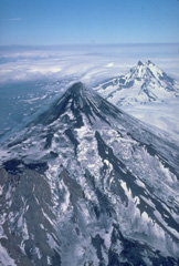 Despite its extensive glacial cover, Shishaldin volcano maintains its symmetrical profile because of frequent eruptions. Aa lava flows, erupted from summit and satellitic vents, spread over the NW flank, the location of more than 2 dozen pyroclastic cones. The dominantly basaltic volcano is the highest peak in the Aleutian Islands. The rugged, dissected Isanotski volcano rises to the east behind Shishaldin.
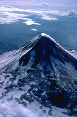 An almost constant steam plumes pours down the north flank of Shishaldin volcano, the highest in the Aleutian Islands. The symmetrical volcano is the most prominent landmark on Unimak Island and is referred to by the Aleut Indians as Sisquk, meaning "mountain which points the way when I am lost." A large monogenetic cinder cone field is found on the NW flank of the basaltic volcano. The two large lakes in the distance are within Fisher caldera, a low-lying volcanic structure to the SW.
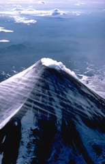 The small summit crater of symmetrical Shishaldin volcano produces an almost constant steam plume. Strong winds in this 1978 view from the east also sweep streams of linear atmospheric clouds across the flanks of the volcano. The dominantly basaltic volcano is built atop an older volcano, remnants of which can be seen on the west and NE sides.
 The effects of differential erosion are dramatically seen in this aerial view of two Alaskan volcanoes. Isanotski volcano in the foreground, sometimes referred to as "Ragged Jack," has been extensively dissected by glaciers that have excavated steep walls separated by narrow ridges. The symmetrical Shishaldin volcano in the background is sometimes referred to as the Mount Fuji of the Aleutians. In contrast to Isanotski, Shishaldin is one of Alaska's most active volcanoes. Frequent eruptions maintain the young, constructional profile of the volcano.
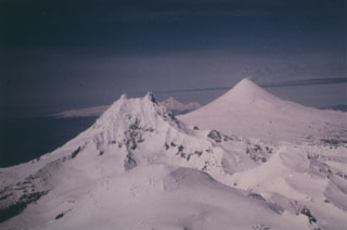 Three volcanoes are constructed along an E-W trend on the eastern half of Unimak Island. Roundtop in the foreground is glacially eroded and has Holocene pyroclastic flow deposits and a group of lava domes to the south. Isanotski is in the background and Shishaldin is in the midground.
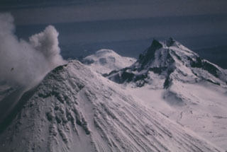 Unimak Island has three volcanoes constructed along an E-W line. Shishaldin is in the foreground and is the highest of the three in this 1987 photo. Isanotski is to the right and Roundtop is in the far distance.
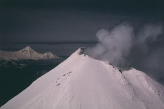 This view of the summit of Shishaldin shows its near- constant crater plume, with its high point on the south rim. Pogromni volcano, part of the Westdahl volcanic complex at the western end of Unimak Island, forms the peak in the distance.
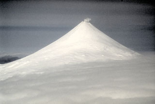 Shishaldin, located on central Unimak Island in the Aleutians, has a summit crater that emits a nearly continuous plume. It is the highest and one of the most active volcanoes of the Aleutian Islands. There have been frequent Strombolian eruptions, sometimes with lava flows, since the 18th century.
There are no samples for Shishaldin in the Smithsonian's NMNH Department of Mineral Sciences Rock and Ore collection.
| Alaska Volcano Observatory (Link to Shishaldin) | The Alaska Volcano Observatory (AVO) is a joint program of the U.S. Geological Survey (USGS), the Geophysical Institute of the University of Alaska Fairbanks (UAFGI), and the State of Alaska Division of Geological and Geophysical Surveys (ADGGS). AVO was formed in 1988, and uses federal, state, and university resources to monitor and study Alaska's hazardous volcanoes, to predict and record eruptive activity, and to mitigate volcanic hazards to life and property. |
| Copernicus Browser | The Copernicus Browser replaced the Sentinel Hub Playground browser in 2023, to provide access to Earth observation archives from the Copernicus Data Space Ecosystem, the main distribution platform for data from the EU Copernicus missions. |
| MIROVA | Middle InfraRed Observation of Volcanic Activity (MIROVA) is a near real time volcanic hot-spot detection system based on the analysis of MODIS (Moderate Resolution Imaging Spectroradiometer) data. In particular, MIROVA uses the Middle InfraRed Radiation (MIR), measured over target volcanoes, in order to detect, locate and measure the heat radiation sourced from volcanic activity. |
| MODVOLC Thermal Alerts | Using infrared satellite Moderate Resolution Imaging Spectroradiometer (MODIS) data, scientists at the Hawai'i Institute of Geophysics and Planetology, University of Hawai'i, developed an automated system called MODVOLC to map thermal hot-spots in near real time. For each MODIS image, the algorithm automatically scans each 1 km pixel within it to check for high-temperature hot-spots. When one is found the date, time, location, and intensity are recorded. MODIS looks at every square km of the Earth every 48 hours, once during the day and once during the night, and the presence of two MODIS sensors in space allows at least four hot-spot observations every two days. Each day updated global maps are compiled to display the locations of all hot spots detected in the previous 24 hours. There is a drop-down list with volcano names which allow users to 'zoom-in' and examine the distribution of hot-spots at a variety of spatial scales. |
|
WOVOdat
Single Volcano View Temporal Evolution of Unrest Side by Side Volcanoes |
WOVOdat is a database of volcanic unrest; instrumentally and visually recorded changes in seismicity, ground deformation, gas emission, and other parameters from their normal baselines. It is sponsored by the World Organization of Volcano Observatories (WOVO) and presently hosted at the Earth Observatory of Singapore.
GVMID Data on Volcano Monitoring Infrastructure The Global Volcano Monitoring Infrastructure Database GVMID, is aimed at documenting and improving capabilities of volcano monitoring from the ground and space. GVMID should provide a snapshot and baseline view of the techniques and instrumentation that are in place at various volcanoes, which can be use by volcano observatories as reference to setup new monitoring system or improving networks at a specific volcano. These data will allow identification of what monitoring gaps exist, which can be then targeted by remote sensing infrastructure and future instrument deployments. |
| Volcanic Hazard Maps | The IAVCEI Commission on Volcanic Hazards and Risk has a Volcanic Hazard Maps database designed to serve as a resource for hazard mappers (or other interested parties) to explore how common issues in hazard map development have been addressed at different volcanoes, in different countries, for different hazards, and for different intended audiences. In addition to the comprehensive, searchable Volcanic Hazard Maps Database, this website contains information about diversity of volcanic hazard maps, illustrated using examples from the database. This site is for educational purposes related to volcanic hazard maps. Hazard maps found on this website should not be used for emergency purposes. For the most recent, official hazard map for a particular volcano, please seek out the proper institutional authorities on the matter. |
| IRIS seismic stations/networks | Incorporated Research Institutions for Seismology (IRIS) Data Services map showing the location of seismic stations from all available networks (permanent or temporary) within a radius of 0.18° (about 20 km at mid-latitudes) from the given location of Shishaldin. Users can customize a variety of filters and options in the left panel. Note that if there are no stations are known the map will default to show the entire world with a "No data matched request" error notice. |
| UNAVCO GPS/GNSS stations | Geodetic Data Services map from UNAVCO showing the location of GPS/GNSS stations from all available networks (permanent or temporary) within a radius of 20 km from the given location of Shishaldin. Users can customize the data search based on station or network names, location, and time window. Requires Adobe Flash Player. |
| DECADE Data | The DECADE portal, still in the developmental stage, serves as an example of the proposed interoperability between The Smithsonian Institution's Global Volcanism Program, the Mapping Gas Emissions (MaGa) Database, and the EarthChem Geochemical Portal. The Deep Earth Carbon Degassing (DECADE) initiative seeks to use new and established technologies to determine accurate global fluxes of volcanic CO2 to the atmosphere, but installing CO2 monitoring networks on 20 of the world's 150 most actively degassing volcanoes. The group uses related laboratory-based studies (direct gas sampling and analysis, melt inclusions) to provide new data for direct degassing of deep earth carbon to the atmosphere. |
| Large Eruptions of Shishaldin | Information about large Quaternary eruptions (VEI >= 4) is cataloged in the Large Magnitude Explosive Volcanic Eruptions (LaMEVE) database of the Volcano Global Risk Identification and Analysis Project (VOGRIPA). |
| EarthChem | EarthChem develops and maintains databases, software, and services that support the preservation, discovery, access and analysis of geochemical data, and facilitate their integration with the broad array of other available earth science parameters. EarthChem is operated by a joint team of disciplinary scientists, data scientists, data managers and information technology developers who are part of the NSF-funded data facility Integrated Earth Data Applications (IEDA). IEDA is a collaborative effort of EarthChem and the Marine Geoscience Data System (MGDS). |