Report on Momotombo (Nicaragua) — June 2000
Bulletin of the Global Volcanism Network, vol. 25, no. 6 (June 2000)
Managing Editor: Richard Wunderman.
Momotombo (Nicaragua) Increased seismic activity in June
Please cite this report as:
Global Volcanism Program, 2000. Report on Momotombo (Nicaragua) (Wunderman, R., ed.). Bulletin of the Global Volcanism Network, 25:6. Smithsonian Institution. https://doi.org/10.5479/si.GVP.BGVN200006-344090
Momotombo
Nicaragua
12.423°N, 86.539°W; summit elev. 1270 m
All times are local (unless otherwise noted)
Seismicity remained stable between November 1999 and April 2000. In May 2000 a seismic swarm began near the volcano, and in June there was heightened seismicity.
During 9-11 June the INETER seismic network registered over 500 earthquakes near Momotombo, 100 of which were located. Many of the earthquakes were between M 3.4 and 4.1 (figure 8), and occurred at depths less than 5 km. The small epicentral area was directly under a geothermal plant on the S slope of the volcano, between Momotombo's crater and the coast of Lake Managua. A similar area was the site of seismic swarms in past years, with the most recent occurrence in May 2000. Some of the earthquakes on 9 June were felt by the personnel of the geothermal plant 5 km SW of the crater and one was felt by several people in the town of Nagarote. INETER stated that an eruption could affect the geothermal plant's 96 employees, as well as residents of towns bordering the volcano. Continuous seismic tremor was also observed at the volcano, which was attributed to volcanic processes rather than movements at tectonic faults. The number of seismic events began to decrease on 11 June. From 12 to 13 June, 60 earthquakes occurred with seven epicenters located. In comparison, 150 earthquakes occurred from 9 to 10 June with 38 epicenters located. After 13 June the number of earthquakes gradually decreased to normal levels.
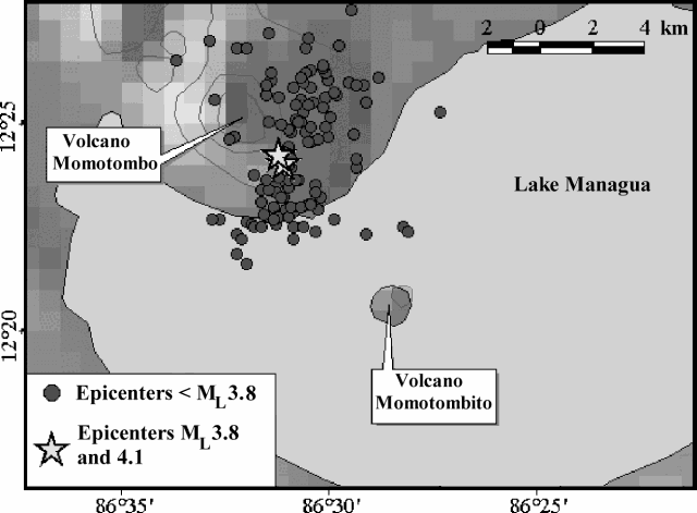 |
Figure 8. Locations of earthquake epicenters at Momotombo with magnitudes less than 3.8 (circles), and magnitudes between 3.8 and 4.1 (stars) from 9 to 16 June 2000. Courtesy of INETER. |
Julio Alvarez, Jorge Cross, Arming Saballos (all INETER/Vulcanología), and Eduardo Mayorga visited the volcano on 15 June to measure the temperature of fumaroles in the crater zone. Temperature measurements conducted at fumaroles in the volcano's dome yielded values between 255 and 933 °C (figure 9). The highest temperature was found near the N edge of the crater.
 |
Figure 9. Sketch of Momotombo's active crater showing fumarole temperatures on 15 June 2000. Areas of fumarolic activity are gray. View is towards the S; the crater is ~ 150 m wide. Courtesy of INETER. |
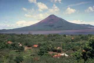
Geological Summary. Momotombo is a young stratovolcano that rises prominently above the NW shore of Lake Managua, forming one of Nicaragua's most familiar landmarks. Momotombo began growing about 4500 years ago at the SE end of the Marrabios Range and consists of a somma from an older edifice that is surmounted by a symmetrical younger cone with a 150 x 250 m wide summit crater. Young lava flows extend down the NW flank into the 4-km-wide Monte Galán caldera. The youthful cone of Momotombito forms an island offshore in Lake Managua. Momotombo has a long record of Strombolian eruptions, punctuated by occasional stronger explosive activity. The latest eruption, in 1905, produced a lava flow that traveled from the summit to the lower NE base. A small black plume was seen above the crater after a 10 April 1996 earthquake, but later observations noted no significant changes in the crater. A major geothermal field is located on the south flank.
Information Contacts: Wilfried Strauch and Virginia Tenorio, Dirección General de Geofísica, Instituto Nicaragüense de Estudios Territoriales (INETER), Apartado 1761, Managua, Nicaragua (URL: http://www.ineter.gob.ni/).