Report on Ioto (Japan) — September 2001
Bulletin of the Global Volcanism Network, vol. 26, no. 9 (September 2001)
Managing Editor: Richard Wunderman.
Ioto (Japan) In September, a submarine eruption; in October, a phreatic eruption pierces beach
Please cite this report as:
Global Volcanism Program, 2001. Report on Ioto (Japan) (Wunderman, R., ed.). Bulletin of the Global Volcanism Network, 26:9. Smithsonian Institution. https://doi.org/10.5479/si.GVP.BGVN200109-284120
Ioto
Japan
24.751°N, 141.289°E; summit elev. 169 m
All times are local (unless otherwise noted)
A submarine eruption at Iwo-jima, off of the island's SE coast, on 21 September was the first reported volcanic activity since November 1982 when an earthquake swarm and weak steam explosions occurred at Asodai Crater (SEAN 08:04). Approximately 1 month after the submarine eruption on the SE side of the island, a small phreatic eruption occurred at Idogahama, a beach on the NW coast of the island.
At 1015 on 21 September a submarine eruption began off of the SE coast of Iwo-jima, an island inhabited by U.S. and Japanese military personnel approximately 1,250 km S of Tokyo. The Japan Maritime Self Defense Force stationed on Iwo-jima observed the eruption, which was preceded by isolated and continuous tremor beginning on 20 September at 2000. Visible evidence of the eruption consisted of seawater gushing several meters above sea level near the island's SE coast. In addition, the eruption was accompanied by an area of discolored seawater extending 300-400 m in length. During 1000-1100 approximately 30 earthquakes occurred in the active area; the typical rate is one or two earthquakes per hour.
The climax of the eruption occurred during 1300-1500. At about 1300 water gushed ~40 m above sea level and accompanying steam rose to 100-300 m. During 1515-1715, Japan Meteorological Agency (JMA) personnel observed seawater rising intermittently in two small dark-gray colored areas 50 m apart and 150-200 m from the island's SE coast (Okinahama beach). The two areas were surrounded by zones of bubbling, white-colored water. The water outside the bubbling zone was emerald green in color. A plume of water rose every few to ten minutes in the western-most area. Measurements with an infrared thermometer revealed that the temperatures in these two areas were 33-34°C and 50°C, while the surrounding water was at 27°C. An approximately 8-km-long and 500-m-wide area of discolored water stretched away from the two areas. By 1500 the number of earthquakes decreased from 30 per hour to about ten. During 1600-1700 three eruption sites were visible; at one a pyroclastic cone was slightly above the sea surface (figures 1 and 2).
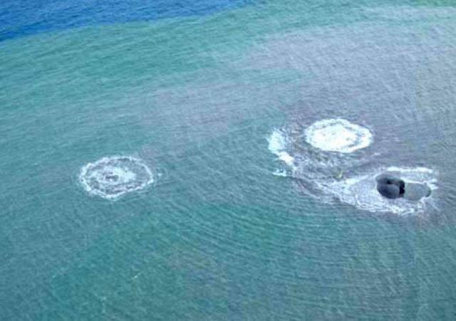 |
Figure 1. Photograph showing three activity sites off the SE coast of Iwo-jima on 21 September 2001 during 1600-1700. Water depth in this area is less than 10 m. A pyroclastic cone that rose above the sea surface is visible at the site furthest to the right; at sea level the diameter of the cone was ~10 m. The coast (Okinahama beach) is approximately 150-200 m to the W (right on the photo). Photo courtesy of Mr. Odai, JMA. |
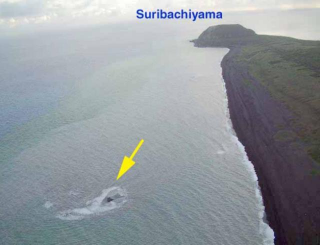 |
Figure 2. Submarine eruption off the SE coast of Iwo-jima on 21 September 2001 during 1600-1700. The arrow indicates the location of the bubbling water shown in figure 1. The photo was taken facing towards the SW coast of the island. Okinahama beach is visible to the right. Photo courtesy of Mr. Odai, JMA. |
JMA reported that the day after the eruption, 22 September, volcanic and seismic activity returned to usual levels, with no water plumes observed and 0-4 earthquakes per hour. In addition, the isolated and continuous tremor events that were recorded during the night of 20 September to the morning of 22 September temporarily ceased. After 21 September areas of discolored water were still visible (figure 3). Until about 28 September many earthquakes and tremor were detected. Results are pending from the analysis of floating pumice that was collected along Iwo-jima's coast after the eruption. Until at least 10 October areas of discolored water were occasionally seen; these were smaller than when the submarine eruption began on 21 September.
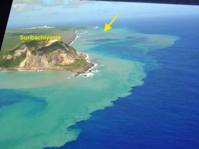 |
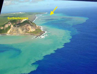
Figure 3. View of the SE side of Iwo-jima on 22 September during 1300-1400, about 27 hours after the start of a submarine eruption. The arrow indicates the location of bubbling water seen the day before. An area of green and tan discolored water (light water near the coast on the photo) is visible extending an unstated distance along and beyond the SE coast. Photo courtesy of Mr. Nakahori, JMA. |
After 21 September there was no volcanic activity at Iwo-jima until 19 October. On the morning of 19 October a small phreatic eruption was observed at Idogahama, a beach on the NW coast of the island. The last reported volcanic activity at Idogahama occurred in March 1982 and consisted of a small phreatic eruptions (SEAN 07:09). The Japan Maritime Self Defense Force observed a grayish-white colored plume rising to 200-300 m above the beach surface for 2-3 minutes starting at about 0725. Another similarly sized plume was observed for 10 minutes starting at 0806. JMA, with support from the Japan Maritime Self Defense Force and the Japan Air Self Defense Force, observed the eruption from a helicopter soon after it began.
JMA personnel observed the eruption during 1602-1715 and measured the temperature of the eruption site with an infrared camera. They estimated that the main crater formed during the eruption was about 10 m long and 2-3 m deep. Inside the crater, every 10 minutes intermittent gushing of black water and entrained debris was observed (figure 4). An accompanying white steam plume reached a maximum height of 600 m above the beach during the observations. The temperature inside the crater was 56°C.
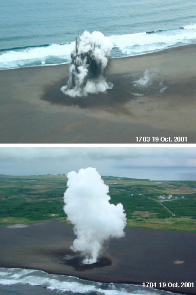 |
Figure 4. Small phreatic eruption at Idogahama, a beach on the NW coast of Iwo-jima, at 1703 (top) and 1704 (bottom) on 19 October 2001. The crater is about 10 m long and 2-3 m deep. The steam cloud rose to a maximum height of 600 m above the beach. Photo courtesy of Mr. Odai and Mr. Nakahori, JMA. |
Geological Summary. Ioto, in the Volcano Islands of Japan, lies within a 9-km-wide submarine caldera. The volcano is also known as Ogasawara-Iojima to distinguish it from several other "Sulfur Island" volcanoes in Japan. The triangular, low-elevation, 8-km-long island narrows toward its SW tip and has produced trachyandesitic and trachytic rocks that are more alkalic than those of other volcanoes in this arc. The island has undergone uplift for at least the past 700 years, accompanying resurgent doming of the caldera; a shoreline landed upon by Captain Cook's surveying crew in 1779 is now 40 m above sea level. The Motoyama plateau on the NE half of the island consists of submarine tuffs overlain by coral deposits and forms the island's high point. Many fumaroles are oriented along a NE-SW zone cutting through Motoyama. Numerous recorded phreatic eruptions, many from vents on the W and NW sides of the island, have accompanied the uplift.
Information Contacts: Setsuya Nakada, Volcano Research Center, Earthquake Research Institute, University of Tokyo, Yayoi 1-1-1, Bunkyo-ku, Tokyo 113-0032, Japan (URL: http://www.eri.u-tokyo.ac.jp/VRC/index_E.html); Mr. Odai, Mr. Nakahori, and Tomoyuki Kanno, Volcanological Division, Seismological and Volcanological Department, Japan Meteorological Agency (JMA), 1-3-4 Ote-machi, Chiyoda-ku, Tokyo 100 Japan (URL: http://www.jma.go.jp/).