Report on Nyiragongo (DR Congo) — April 2002

Bulletin of the Global Volcanism Network, vol. 27, no. 4 (April 2002)
Managing Editor: Richard Wunderman.
Nyiragongo (DR Congo) French-British scientific team field work report on the 17-18 January eruption
Please cite this report as:
Global Volcanism Program, 2002. Report on Nyiragongo (DR Congo) (Wunderman, R., ed.). Bulletin of the Global Volcanism Network, 27:4. Smithsonian Institution. https://doi.org/10.5479/si.GVP.BGVN200204-223030
Nyiragongo
DR Congo
1.52°S, 29.25°E; summit elev. 3470 m
All times are local (unless otherwise noted)
The following was extracted from the 8 March final report of the French-British Scientific Team on the January 2002 Nyiragongo eruption (Allard and others, 2002). On 22 January the team, comprised of Patrick Allard, Peter Baxter, Michel Halbwachs, and Jean-Christophe Komorowski, joined local scientists of the Goma Volcano Observatory (GVO), and the UN-OCHA team (Jacques Durieux, Paolo Papale, Dario Tedesco, and Orlando Vaselli) in Goma.
Precursory signals. The January 2002 eruption of Nyiragongo volcano was heralded by precursory phenomena detected since March 2001 by volcanologists of the GVO. Anomalous seismicity occurred. It included both type-C long-period (LP) events and tremor, which persisted after the February-March 2001 eruption of Nyamuragira (BGVN 26:03), 15 km NW of Nyiragongo, and had increased gently over the rest of the year. LP events and volcanic tremor were mainly registered at the Bulengo seismic station (15 km W of Goma) and were minimal, or absent, at the more remote (40 km) Katale station, located closer to Nyamuragira (Akumbi Mbiligi, GVO, pers. comm.). This observation supported the idea of seismo-magmatic processes occurring at, or closer to, Nyiragongo. This was later confirmed by the registration of earthquake swarms (presumed fracturing events) in the Nyiragongo area: first in October 2001 and then on 4 January 2002, 13 days prior to the eruption's onset. The 4 January earthquakes were accompanied by a darkened plume and rumbling sounds at the summit of Nyiragongo (Akumbi and Kasareka, GVO, pers. comm.).
A fracture from the 1977 eruption runs above Shaheru crater (2,700 m elevation and ~2 km S of the summit, figure 15). A fumarolic vent formed at ~2,800 m elevation along this fracture in October 2001. New cracks and increased fumarolic activity were also detected on the southern inner wall of the summit crater, upslope of Shaheru crater. In November 2001, new fumaroles appeared on the N floor of Shaheru crater itself.
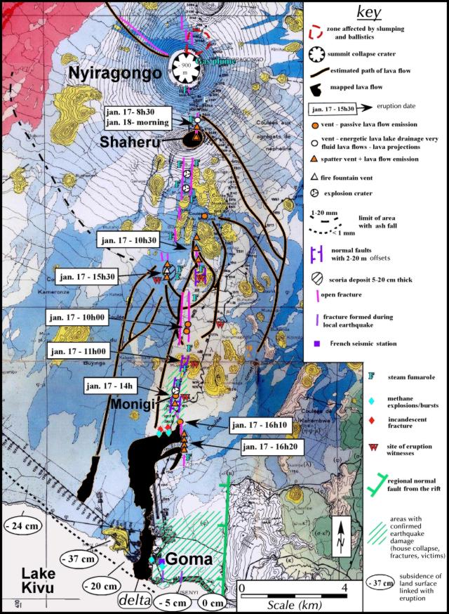 |
Figure 15. Map showing the eruptive chronology, the lava flow field, and phenomena associated with the 17-18 January 2002 eruption of Nyiragongo (geologic base map taken from Thonnard and others, 1965). The map compiles observations of the French-British scientific team, together with the UN volcano surveillance team, the Goma Volcano Observatory, Minerena (Rwanda), UN-OCHA mapping, and includes contributions by D. Garcin and collaborators from the UN, and observers in Goma (subsidence and eyewitness data). Information was preliminary as of 9 February 2002 and subject to change. Courtesy of the French-British team. |
An increase in seismicity during 4-17 January included several felt earthquakes and volcanic tremor. On 16 January, a few hours before the eruption onset, an abnormally strong smell of sulfur dioxide was also noticed by the pilot of a small private aircraft flying N of Nyiragongo (Ted Hoaru, pers. comm.).
Chronology of the eruption. According to GVO, Nyiragongo started erupting at 0825 on 17 January. Earthquakes caused the 1977 fracture system running from 2,800 m elevation into Shaheru crater to open and drain the lava stored in the summit crater. The height and energy of the discharging lava during this initial phase is demonstrated by lava boulders that were perched 6-8 m high in trees at distances up to 30 m from the eruptive fracture above Shaheru. Very fluid lava flows, only 10-15 cm thick at their source, moved across the forested SE slopes of Nyiragongo and rapidly cut the road going N from Goma. The outpouring lava left high-stand marks on trees up to a height of 1.5 m upslope of, and within, Shaheru. The 800-m-wide Shaheru crater was filled with a 3-m-thick lava pond.
Two sets of parallel eruptive fractures, ~300 m apart, further propagated through the S flank of Shaheru cone and extended downslope forming a series of grabens (~5-10 m wide) cutting across banana groves, villages, and older volcanic cones. Between 1000 and 1100, lava flows issued from a series of eruptive vents at ~2,300-1,800 m elevation along this system (figure 16), devastating several villages. Between 1400 and 1620 fractures approached the outskirts of Goma and began to form a line of vents SE of Monigi village only 1.5 km NE of Goma airport (see figure 15, including points labeled 1610 and 1620). These lowest fractures produced intense spattering. This led to the voluminous lava flow that ran through the airport and the heart of Goma, finally entering Lake Kivu during the night. Other eruptive vents that opened higher on the volcano produced voluminous lava flows that also reached Goma. Most of these flows were of aa-type, less fluid, black, and 1-3 m thick. Visible fracturing occurred simultaneously with the onset of lava effusions.
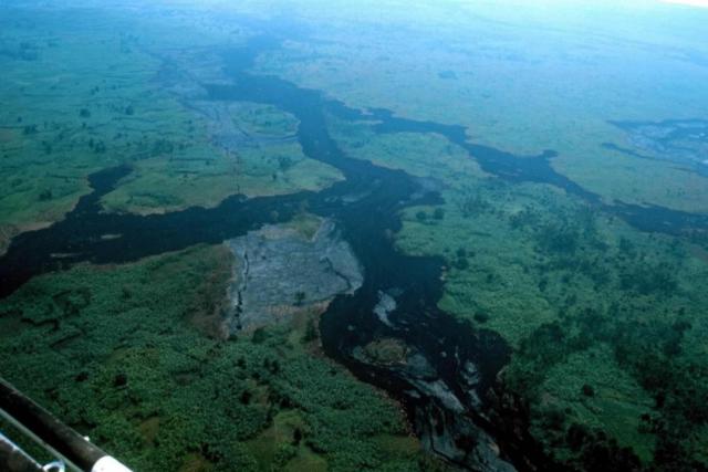 |
Figure 16. Aerial view at Nyiragongo after the January 2002 eruption, showing part of the lava flow field S of Lemera hill and N of Mugara hill. Notice the system of parallel fractures that runs from N (bottom of photo) to S (top of photo), a fissure-vent system that in this instance produced very fluid, pahoehoe lava flows (under 1 m thick). Photo by Jean-Christophe Komorowski. Courtesy of the French-British team. |
Another eruptive fissure opened at 1530 at 2,250 m elevation (figure 15) (2 km W of Kibati). Eyewitnesses reported that this western fissure initially produced passively effusive activity feeding pahoehoe lava flows. However, the presence of a scoria-fall deposit extending over 500 m around the vent indicated at least momentary lava fountaining. Lava flows there were voluminous, aa-type, and 1-2 m thick, that cascaded down a significant sector of the volcano (figure 17). These fed a flow advancing towards Monigi and formed the second main flow that reached Goma on the W, stopping a few kilometers from Lake Kivu.
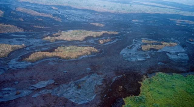 |
Figure 17. Detail of the large pahoehoe and aa lava flows emitted by Nyiragongo during January 2002 from the W vent, which fed a large flow that reached Goma but not Lake Kivu. The two types of lavas were emitted simultaneously and did not exceed 2 m thick. Photo by Jean-Christophe Komorowski. Courtesy of the French-British team. |
From helicopter and ground-based studies of the lava flows the team estimated a total erupted volume of between 20 and 30 x 106 m3, including the lava that flowed into Lake Kivu. First analyses of bulk rock samples (table 3) revealed that lavas erupted from the highest and lowest fractures had very similar compositions, implying their derivation from a single magma batch. These otherwise degassed lavas still contained very high bulk amounts of S, F, and Cl, with slightly higher contents in the products of spattering activity along the Monigi fracture zone. Moreover, the 2002 Nyiragongo lavas are similar to the leucite-bearing nephelinite lavas produced during the 1977 eruption.
Table 3. Chemical analyses of lavas from the January 2002 and January 1977 Nyiragongo eruptions. Analysis at CRPG, CNRS, Vandoeuvre-Les-Nancy, France. All values in wt % (P. Allard, unpublished data, 2002). Courtesy of the French-British team.
| Sample | PA-2 | PA-4 | PA-1 | PA-0 |
| Date | 17 Jan 2002 | 17 Jan 2002 | 17 Jan 2002 | 10 Jan 1977 |
| Site | Upper lava flow | Spatter cone | Main lava flow | 1977 eruption |
| Elev (m) | Shaheru: 2,760 | Munigi: 1,680 | Goma center: 1,540 | Kibati: 2,000 |
| SiO2 | 39.27 | 39.38 | 39.37 | 39.30 |
| Al2O3 | 14.99 | 14.96 | 15.05 | 15.02 |
| Fe2O3 | 13.44 | 13.21 | 13.48 | 13.89 |
| MnO | 0.29 | 0.29 | 0.29 | 0.30 |
| MgO | 4.06 | 4.05 | 4.11 | 4.05 |
| CaO | 12.49 | 12.61 | 12.60 | 12.19 |
| Na2O | 5.94 | 6.10 | 6.01 | 5.57 |
| K2O | 5.69 | 5.72 | 5.70 | 5.65 |
| TiO2 | 2.74 | 2.68 | 2.73 | 2.83 |
| P2O5 | 1.29 | 1.25 | 1.29 | 1.30 |
| Total | 99.79 | 99.83 | 100.17 | 99.69 |
| S tot | 0.18 | 0.22 | 0.19 | 0.15 |
| F | 0.27 | 0.29 | 0.28 | 0.25 |
| Cl | 0.095 | 0.118 | 0.103 | 0.063 |
The UN reported 147 deaths (of whom 60-100 died in an explosion of the Goma central petrol station on 21 January), 30,000 people displaced, and 14,000 homes destroyed by the eruption. Around 470 injured people reportedly suffered burns, fractures, and gas intoxication. However, Peter Baxter reviewed health aspects of the eruption during a visit to Goma in March, and found no evidence for a large number of people injured or killed. He places the number of deaths at about 70, of which 20 occurred as a result of the petrol station explosion; only a few burn injuries needed hospital treatment, and none of those were serious.
As many as 350,000 people fled from the advancing lava, principally towards nearby Rwanda to the E. After two days the majority returned to Goma, despite hazards from hot lava and burning materials. Despite the lack of observers on the scene at the time, it seems that lava emission stopped during the early morning of 18 January, indicating that the entire flank eruption lasted ~24 hours. However, molten lava continued to flow in tunnels and tubes along the main flow that had reached Lake Kivu and spilled into it for a few more days. This created a new fan-shaped lava delta ~800 m across at its widest point along the previous shoreline. Lava flows destroyed part of the airport and Goma's business and commercial center.
Crater collapse and explosive activity. According to Jacques Durieux (UN-OCHA), the solidified lava floor of Nyiragongo summit crater, lying at 320 m below the rim since 1996, was still in place on 21 January, three days after the end of the eruption, but was cut by a N-S steaming graben. It is most likely that this chilled crater floor, although thick enough to initially resist falling, had been weakened by the lava drainage during 17-18 January. Its broad-scale collapse occurred during the night of 22-23 January. A detailed report by eyewitnesses in Rusaya (8 km SW of the summit) indicated that collapse started at 2051 on 22 January, coinciding with a series of felt earthquakes. It was accompanied by roaring sounds and glow above the crater and followed soon after by hot ashfall over Rusaya, that reportedly formed a layer 10 cm thick. GVO registered intense and continuous seismic tremor over the next four hours. Light ashfall also took place over Goma and Gisenyi that night. A helicopter flight on 24 January allowed the team to observe the ash cover on the forested SW flank. They found Nyiragongo's new crater floor ~700 m (instead of 320 m) below the rim, with a blocky and fuming narrow bottom partly covered by remnants of the former crater floor.
Changes in crater morphology correspond to an estimated bulk volume of ~30 x 106 m3 removed during previous lava drainage and subsequent (unquantified but likely secondary) ash emission. This figure compares well with the bulk volume of lava flows, suggesting that these mainly derived from the lava stored in the crater and upper conduit of the volcano. This conclusion is consistent with the identical composition of bulk lava flow samples from the upper and lower fissure vents (table 3).
Intermittent phreatomagmatic explosive activity inside Nyiragongo crater persisted after the collapse. At 0910 on 24 January a dense cloud was visible above the volcano. On 27 January fresh impacts and fresh tree-destructions were discovered in the forest on the upper N flank. Phreatomagmatic activity in the crater was observed directly on 3 February by GVO volcanologist M. Kasareka who had climbed to the summit.
Fracture system. A large fracture system cut the volcano over an elevation range of 1,100 m and extendeed 20 km from N to S, reaching to within 1 km of Goma (figure 15). In some places along the fractures eruptive vents and phreatic (explosion-caused) craters formed. Field observations, combined with eyewitness accounts confirmed the opening of fractures and emission of lava flows either simultaneously or in close succession during the eruption. The overall fissure propagation velocity averaged 2 km/hour. However, massive post-eruptive fracturing was also observed in some places, correlated with intense post-eruptive seismicity. Two weeks after the eruption strong steaming persisted in several sections of the fracture system.
The system of fractures was spectacularly developed in the Monigi area (1,700 m elevation) where it consists of a down-dropped zone ~25-50 m wide with up to 20 m of vertical downward displacement along vertical walls that extend across the topography for ~2 km (figures 18-20). Several fractures opened 1-3 m and ran parallel on either side of the main fault system; they extended out to a distance of 100-300 m from the axis. The fault system passed through several villages (Kasenyi, Buganra). Continuous steaming (60-80°C) was occurring along the faults. Locally, steam vents formed craters 10-15 m deep.
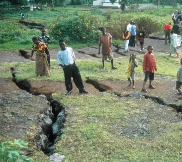 |
Figure 18. Fracture and fault system developed at Nyiragongo on 17 January 2002 in Monigi village. Continuing, strongly felt, post-eruptive seismicity further opened the fractures. Some openings in fissures reached up to 2 m wide and 5-10 m deep. Photo by Jean-Christophe Komorowski. Courtesy French-British team. |
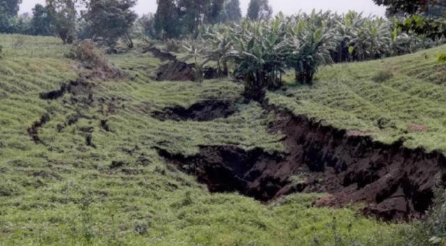 |
Figure 19. Fracture system N of Monigi village at Nyiragongo following the January 2002 eruption. The area between the fractures had dropped by ~ 2 m to form a graben (note leaning trees). Steam vented locally from deep pits (5-10 m). Earth cracks parallel to the main depression extend out to ~ 20-30 m. Photo by Jean-Christophe Komorowski. Courtesy French-British team. |
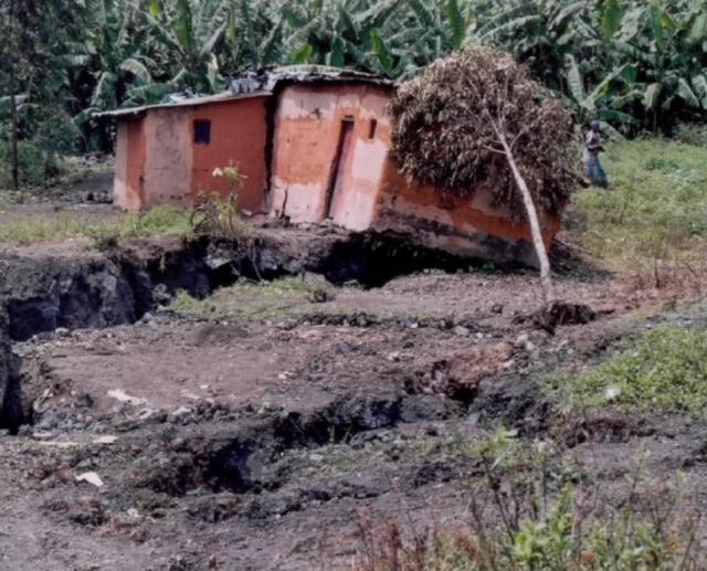 |
Figure 20. A displaced mud-brick house located on the main fracture in Monigi village following the January 2002 eruption of Nyiragongo. The fracture here behaved as a normal fault, with vertical displacement of ~ 0.5 m. Photo by Jean-Christophe Komorowski. Courtesy French-British team. |
A 50- to 80-cm-wide fracture at Monigi village also channeled lava to the surface where it formed a thin chilled margin (figure 21). Withdrawal of magma during the fracture's southward propagation, as confirmed by eyewitness accounts, left a drained lava tube. In a few locations lava spatter was ejected up to 15 m away from the fracture indicating short-lived gas-rich lava venting.
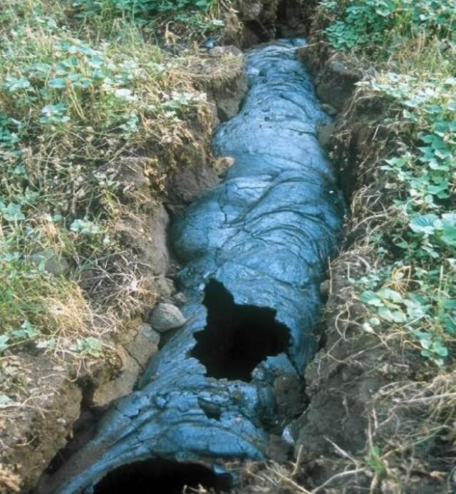 |
Figure 21. The 17-18 January 2002 eruption of Nyiragongo produced this fissure or dike, found near the village of Monigi (figure 15). The dike is ~ 0.6-0.8 m wide and contains a glassy outer envelope of chilled lava (a shell somewhat like a small lava tube). The still-fluid portion of lava drained away southward through the dike conduit towards Goma. Photo by Jean-Christophe Komorowski. Courtesy of the French-British team. |
Fracturing occurred over a short time between 1000 and 1300 from N to S, cutting through thick scoria-cone deposits (figure 22) as well as lava flows several meters thick. Fractures left openings 5-10 m deep. The system transected the W flanks of the Mubara cinder cone, where fractures spread over an area of 100-200 m forming several sub-parallel strands with 0.2-3 m of vertical displacement. This area could present future slope stability problems.
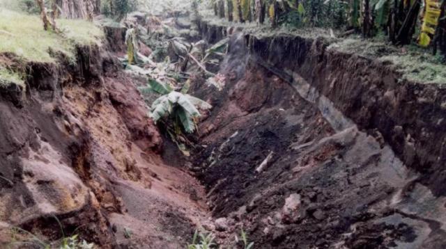 |
Figure 22. Photo following the January 2002 Nyiragongo eruption of the central depression in the Monigi fracture-graben system through old scoria fall deposits from Mugara cinder cone located just N. Width is about 25 m and depth 10-15 m. Local steaming indicated that a dike was near the surface and was involved in the formation of this feature. Photo by Jean-Christophe Komorowski. Courtesy French-British team. |
Seismicity. Intense felt seismic activity occurred during but mainly after the eruption, including tectonic earthquakes M 3.5 or larger. The number of earthquakes gradually declined with time but has remained abnormally high. As of early March 2002, earthquakes were still felt intermittently.
The seismic network that operated during the eruption and up until 30 January did not allow an accurate assessment of the location and depth of earthquakes. However, the short time intervals between the arrival of P and S waves as measured on seismograms indicated local sources. The persistence of numerous LP events and sequences of tremor after the eruption raised concerns about the possibility of continuing magma intrusions and phreato-magmatic eruptions inside the summit crater. This intense post-eruptive seismicity, combined with widespread ground subsidence in the Kivu rift (BGVN 27:03), as well as the synchronism of the eruption with 20-km-long fractures and the broadly consistent volumes of bulk lava flows and summit crater collapse, led the team to propose that the 2002 Nyiragongo eruption was most likely triggered by tectonic spreading of the Kivu rift.
Gas emanations. During and after the eruption people in Goma confronted a variety of gas emissions. Abnormal odors of hydrocarbons were reported in many parts of the city, prompting the use of a portable infrared spectrometer allowing in-situ gas analysis. The team found that the smells were due to hydrocarbon-bearing methane- and CO2-rich gas emanations from the ground, which occurred in areas separated by 300-800 m from the lava flows and which, therefore, had no relationship with organic matter fired or heated by the flows. These emanations, with methane concentrations of a few percent and sometimes approaching the 5% flammability threshold in air were found both outdoors diffusing up through pavements along streets, in gardens, and in buildings. At a school, methane measured under 1%. Near a drain system for rainwater ~200 m from a lava flow's edge methane was found in the air along the ground but at less than 1%. However, at a nearby concrete roof over a drain the methane content was 2%, together with 2% CO2.
A long fissure passed under a church in the center of Goma. CO2 emissions caused two women cleaning the church to faint. According to GVO, similar fractures are scattered throughout the area. Heat from engulfing lava flows led to the combustion of both plants and a wide variety of dissimilar materials (houses, cars, petrol tanks, etc.).
Flames of burning gas and vegetation were observed and analyzed in different parts of the flows, both inside and outside the city. On 23 January the team measured a temperature of 500°C for blue flames burning on a still-hot lava flow. The air in cracks near the flames contained about 2% methane, the smell of which was readily detectable in the area. According to witnesses, on the previous day these flames had been orange in color and 1.5 m high, suggesting that the fire was originally caused by the burning of organic matter inside the flow and that the flames resulted from the combustion of distillates of vegetation. Slow combustion of vegetation and organic matter was widespread after the eruption in all the areas affected by Nyiragongo lava flows.
Numerous gas bursts were reported to have occurred during-but mostly after-the eruption, principally during 20-22 January when the most intense seismicity occurred. No one was injured by the explosions. Eyewitnesses to these events saw that the gas bursts shortly followed strongly felt earthquakes and were accompanied by strong smells of hydrocarbon gas. In several places 300-400 m distant from lava flows, these gas bursts ripped through cement and stone pavement in Goma's houses and streets. Gas concentrations stood at 5% CO2 and 3-4% methane in one case, and at 1% CO2 and 2.6% methane in an office. Not far away in a garage a 21 January explosion had blown apart a concrete floor 10 cm thick. But when visited 4 days later, a measurable gas anomaly was absent.
Most of the gas bursts occurred at places or in areas that are broadly aligned with the N-S fracture system cutting the volcano and where ground gas emanations were persisting. Although these explosions occurred at the time of felt earthquakes, the associated seismically induced ground movement was not severe enough to have been responsible for the observed localized type of damages. The strong gas smells and the elevated methane concentrations were taken as evidence of a methane-driven origin for the explosions. Sub-surface methane concentrations must have been locally high enough to allow spontaneous ignition of the methane upon contact with oxygen during and following seismic loading. Further study will be necessary to elucidate the origin of that methane. The team emphasized that methane is weakly abundant in permanent gas vents (locally called "mazukus") that occur in the area, emanating through old lava flows, such as those to the W of Goma (CO2: 93.2 %; methane, CH4: 0.07% by volume).
The team witnessed a small methane burst on 27 January while inspecting ground fractures in Monigi that displayed persistent incandescence and very high temperatures (970°C on 24 January). These sites are located in the middle of a small village and constitute a major attraction for cooking and for children who play nearby. The fracture, through which no lava had erupted, was formed parallel to the main eruptive fractures but there crosses through thick old lava flows. The team inferred that incandescence was caused by the presence at depth of relict heat from the magma body (dike) that fed the nearby lava flows that covered Goma (within 1 km). The gas burst occurred at ~2 m from the site where maximum incandescence had persisted for a week and where scientists were measuring temperatures and collecting gases. Most likely, the scientific fieldwork brought air in contact with a pocket of methane, which then spontaneously burst. A few fist-sized blocks of old lava were popped up to a distance under 1 m, without causing any injuries to the numerous bystanders. At another site, minor bursts occured every few minutes as wind blew through the fractures.
In contrast, minor explosions of phreatic origin also occasionally occurred in different places. For example, at the lava delta, when molten lava entered Lake Kivu, and at Goma when bulldozing the lava flows suddenly depressurized steam produced by the high temperature of lava flows along the ground.
Gas hazard of Lake Kivu. Lake Kivu (485 m deep) is known to contain an immense amount of both CO2 (1,000 times that in Lake Nyos, Cameroon) and methane stored in solution in its waters. In the case of a major disturbance of the density stratification of gas-charged water in this lake, a huge gas release could occur. Concerns about such a hazard were raised when the lava flowed into the lake, together with the opening of new fractures, strong seismicity, and the poorly understood possibility of an underwater extension of the eruption.
A variety of manifestations were observed at the surface of the lake after the eruption. During 20-21 January, coincident with felt earthquakes, the lake water was seen uprising along the shore 9 km to the W of Goma and, in three separate areas, the water became dark and warm, with gas bubbles and an associated odor (hydrogen sulfide). Many dead fish were seen in and around these areas. Similar phenomena were reported along other sectors of the lake's shore. Additionally, yellow flames were reported to have been seen on occasion at the surface of Lake Kivu well away from the lava flows, suggesting methane burning. Unpleasant odors and experiences were reported by swimmers in Lake Kivu before the eruption, again ascribed to gas emissions. These reports need to be followed up by a survey of gas concentrations at the lake surface.
The hazard of lava flows entering and disturbing the lake waters has not been extensively studied previously. The hot lava could disturb the lake stability by starting lake-water convection. This might trigger a gas burst resulting in a lethal cloud of CO2 and methane flowing over an unknown area around the lake. In order to assess the problem, Halbwachs organized underwater investigations, first with the help of scuba divers from UN-OCHA and, in a second stage (7-10 February), using a submersible sent from France with the support of EC-ECHO.
Local divers reported the presence of hot water (40-60°C) surrounding the lava delta. Gas bubbling could be observed locally, but its limited extent suggested that neither the gases, nor the solidified lava presented a risk for the local water supplies. In contrast, potential hazard from submarine lava tubes required investigations at greater depth. Despite the poor visibility due to abundant particles in suspension, the surveys with the submersible revealed that the lava flow and tubes had descended to ~80 m depth in the lake by the shore at Goma. Fortunately, such a depth is much smaller than the critical depths of 200-300 m at which Lake Kivu's waters contain more abundant dissolved carbon dioxide, closer to the saturation limit.
In order to evaluate the influence of the hot mass of lava that entered into Lake Kivu on its physico-chemical stratification, during early February a series of samples were collected at varying depths, and 40 vertical lake soundings were undertaken. In collaboration with Halbwachs, these measurements were performed by two limnologists: Klaus Tietze (PDT GmbH, Celle, Germany) and Andreas Lorke (EAWAG Laboratory, Lucerne, Switzerland). They measured depth, temperature, pH, electrical conductivity, turbidity (transparency to white light), and dissolved-oxygen content. Preliminary results suggested a change in the water stratification since the last measurements by Klaus Tietze 20 years ago. A new homogenous water layer was found at depths between 200 and 250 m. Near the lava delta the temperature and turbidity profiles showed some perturbations between 50 and 120 m depth. Away from the delta, a thin (3 m) layer of slightly warmer water lay at ~80 m depth. The turbidity was rather low close to the lava flows but increased rapidly away from it. More synthesis and analytical work continues in order to assess fundamental questions on the stability of Lake Kivu stratification.
References. Allard, P., Baxter, P., Halbwachs, M., and Komorowski, J-C, 2002, Final report of the French-British scientific team: submitted to the Ministry for Foreign Affairs, Paris, France, Foreign Office, London, United Kingdom and respective Embassies in Democratic Republic of Congo and Republic of Rwanda, 24 p.
Thonnard, R.L.G., Denaeyer, M-E., and Antun, P., 1965, Carte volcanologique des Virunga (1/50000), Afrique Central, Feuile No. 1: Centre National de Volcanologie (Belgique), Missions Gèologiques et Gèophysiques aux Virunga, Ministère de L'Education et de la Culture, Bruxelles, Belgium.
Geological Summary. The Nyiragongo stratovolcano contained a lava lake in its deep summit crater that was active for half a century before draining catastrophically through its outer flanks in 1977. The steep slopes contrast to the low profile of its neighboring shield volcano, Nyamuragira. Benches in the steep-walled, 1.2-km-wide summit crater mark levels of former lava lakes, which have been observed since the late-19th century. Two older stratovolcanoes, Baruta and Shaheru, are partially overlapped by Nyiragongo on the north and south. About 100 cones are located primarily along radial fissures south of Shaheru, east of the summit, and along a NE-SW zone extending as far as Lake Kivu. Many cones are buried by voluminous lava flows that extend long distances down the flanks, which is characterized by the eruption of foiditic rocks. The extremely fluid 1977 lava flows caused many fatalities, as did lava flows that inundated portions of the major city of Goma in January 2002.
Information Contacts: Patrick Allard, Laboratoire Pierre Süe, CNRS-CEA, Saclay, France; Peter Baxter, University of Cambridge, United Kingdom; Michel Halbwachs, Université de Savoie, Chambéry, France; Jean-Christophe Komorowski, Institut de Physique du Globe de Paris, France.