Report on Santa Maria (Guatemala) — May 2002

Bulletin of the Global Volcanism Network, vol. 27, no. 5 (May 2002)
Managing Editor: Richard Wunderman.
Santa Maria (Guatemala) Active lava flow front continues to generate ash plumes through early 2002
Please cite this report as:
Global Volcanism Program, 2002. Report on Santa Maria (Guatemala) (Wunderman, R., ed.). Bulletin of the Global Volcanism Network, 27:5. Smithsonian Institution. https://doi.org/10.5479/si.GVP.BGVN200205-342030
Santa Maria
Guatemala
14.757°N, 91.552°W; summit elev. 3745 m
All times are local (unless otherwise noted)
During early 2002 the block lava flow that began to extend S from the Caliente vent of Santa María during July 1999 (BGVN 25:06) remained active. As of 19 January 2002 the active flow front was in approximately the same location as during January 2001, ~3.4 km from the vent. The active flow front was ~40 m high and extended over an older, now inactive unit. This inactive unit extends 420 m farther down the narrow ravine of the Río Nimá II (figure 31). The flow front was ~315 m wide and was extremely active, being the source of frequent collapse events generating ash plumes that rose ten's to hundred's of meters.
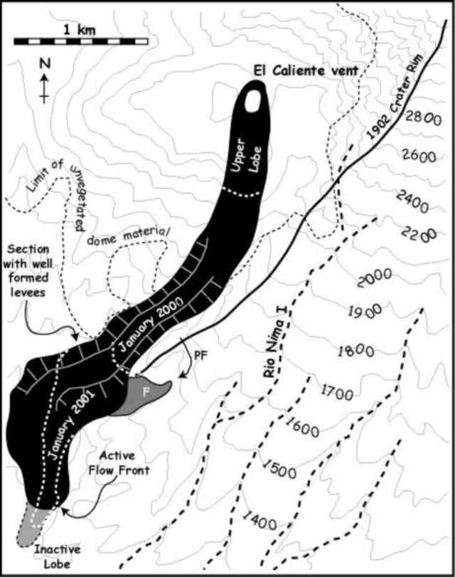 |
Figure 31. Map of the dome of Santa María obtained using a 19 January 2002 Landsat 7 Enhanced Thematic Mapper Plus image. The area shown in black is the extent of the main block lava flow field, along the Río Nimá II ravine, including active and inactive portions. "PF" marks the course of pyroclastic flows from the block-lava flow medial section, and "F" denotes valley fill observed during ground-based observations of this medial section. Courtesy Otoniel Matías, Gustavo Chigna, Yvonne Branan, Lizzette Rodriguez, Gregg Bluth, Matt Watson, Elly Bunzendahl, Janelle Byman, and William I. Rose. |
During a 7.5-hour-long observation period on 10 January, flow front collapses generated ash plumes that reached altitudes sufficient to be observed from 5 km away on 63 occasions. The medial section of the block-lava flow displayed well-formed levees, defining a ~100 m wide channel with typical outer levee heights of 40-75 m. Maximum levee heights of 95-110 m (measured using a laser range finder and using shadows on a Landsat 7 ETM+ image) occurred in the vicinity of the January 2000 flow front location (figure 31). Within the channel, the flow surface was 20-30 m below the levees. The channelized section fed a 300-400 m-wide zone of dispersed flow that extended from the channel mouth to the flow front. This zone consisted of multiple lobes of inactive units, with a central active stream. The distal section was being resurfaced by a new flow lobe. This lobe began extending from the vent around 29 December 2001 and by 19 January 2002 it had extended ~780 m from the vent (advancing at a rate of 65 m per day). The extrusion of this new unit was coincident with a significant explosive/collapse event that generated a small pyroclastic flow down the E flank of the Caliente vent.
As in January 2000 (BGVN, 25:06), the Caliente vent was filled to the brim and the vent area was marked by a low dome-like feature. During 0710-1436 on 10 January, 38 ash eruptions occurred (~5 per hour). Eruptions typically occurred every 30 minutes. However, 10 of these events were paired consisting of two or three emissions separated by 1-5 minutes. Observations from the Santa Maria summit allowed measurements of a ring-shaped (diameter 143 ± 20 m) vent defined by ash-and-gas emissions in the early seconds of brief explosions (figure 32). SO2 flux measurements of the Caliente vent emissions gave large ranges of 15-180 metric tons/day. The larger emission rates are similar to those for the previous two years.
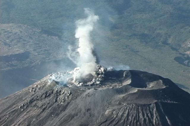 |
Figure 32. View of the Caliente Vent (2,500 m elevation) as seen from Santa María summit (3,772 m elevation) at 0801 on 11 January 2002. The image is part of a digital video sequence at the beginning of an explosive event. The ring-like feature scales to ~ 140 m in diameter. Courtesy Otoniel Matías, Gustavo Chigna, Yvonne Branan, Lizzette Rodriguez, Gregg Bluth, Matt Watson, Elly Bunzendahl, Janelle Byman, and William I. Rose. |
A news article reported that staff from Instituto Nacional de Sismologia, Vulcanologia, Meteorologia e Hidrologia (INSIVUMEH) stated that volcanic activity increased at the Santiaguito dome complex beginning on 11 March 2002. Until at least 14 March near-constant explosions opened fractures on the volcano and emitted ash. Ash rose to 600-900 m above the volcano and fell in the towns of Retalhuleu (25 km SSE of the volcano) and San Marcos, and towards the Mexican border.
Based on information from INSIVUMEH, the Washington VAAC reported that light ash fell near Santa Maria's summit on 13 May and an ash cloud was visible on satellite imagery drifting SW during the morning and more towards the W later in the day. The thickest ash was located very close to the summit, with light ash extending SW.
Geological Summary. Symmetrical, forest-covered Santa María volcano is part of a chain of large stratovolcanoes that rise above the Pacific coastal plain of Guatemala. The sharp-topped, conical profile is cut on the SW flank by a 1.5-km-wide crater. The oval-shaped crater extends from just below the summit to the lower flank, and was formed during a catastrophic eruption in 1902. The renowned Plinian eruption of 1902 that devastated much of SW Guatemala followed a long repose period after construction of the large basaltic andesite stratovolcano. The massive dacitic Santiaguito lava-dome complex has been growing at the base of the 1902 crater since 1922. Compound dome growth at Santiaguito has occurred episodically from four vents, with activity progressing E towards the most recent, Caliente. Dome growth has been accompanied by almost continuous minor explosions, with periodic lava extrusion, larger explosions, pyroclastic flows, and lahars.
Information Contacts: Andy Harris, Luke Flynn, and Mark Davies, HIGP/SOEST, University of Hawai'i, 2525 Correa Road, Honolulu, HI 96822, USA (URL: http://modis.higp.hawaii.edu/); Otoniel Matías and Gustavo Chigna, INSIVUMEH, 7a Av. 14-57, Zona 13, Guatemala City, Guatemala; Yvonne Branan, Lizzette Rodriguez, Gregg Bluth, Matt Watson, Elly Bunzendahl, Janelle Byman, William I. Rose, Department of Geological Engineering and Sciences, Michigan Technological University, Houghton, MI 49931, USA; Simon Carn UMBC, Baltimore, MD USA; Washington VAAC, Satellite Analysis Branch (SAB), NOAA/NESDIS E/SP23, NOAA Science Center Room 401, 5200 Auth Road, Camp Springs, MD 20746, USA (URL: http://www.ssd.noaa.gov/); Prensa Libre (URL: http://www.prensalibre.com/).