Report on Asamayama (Japan) — June 2002
Bulletin of the Global Volcanism Network, vol. 27, no. 6 (June 2002)
Managing Editor: Richard Wunderman.
Asamayama (Japan) Periods of heightened seismicity during September 2000 and June 2002
Please cite this report as:
Global Volcanism Program, 2002. Report on Asamayama (Japan) (Wunderman, R., ed.). Bulletin of the Global Volcanism Network, 27:6. Smithsonian Institution. https://doi.org/10.5479/si.GVP.BGVN200206-283110
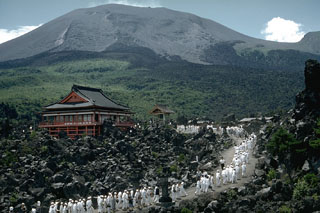
Asamayama
Japan
36.406°N, 138.523°E; summit elev. 2568 m
All times are local (unless otherwise noted)
Asama has a history of periodic heightened seismicity; the last reported seismicity increase occurred in September 1996 (BGVN 21:11). A previously unreported seismic increase began on 18 September 2000. During 18-24 September the Japan Meteorological Agency (JMA) recorded 138, 431, 310, 243, 96, 33, and 14 earthquakes per day, respectively.
During 22-23 June 2002 another period of heightened seismicity occurred at Asama that was similar to the September 2000 activity (figure 15). The earthquakes began at 0100 on 22 June and at 0900 JMA issued a Volcanic Advisory stating that 210 volcanic tremor events had occurred during 0100-0800. The report also stated that the temperature of the crater floor had increased since May 2002; on 19 June the floor was at 180°C. Prior to the heightened seismicity, on 2 and 4 June plumes rose 700 and 1,000 m above Asama's summit, respectively.
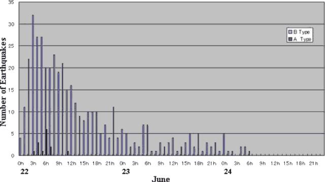 |
Figure 15. Plot showing volcanic earthquakes registered at Asama during 22-24 June 2002. The number of earthquakes peaked on 22 June around 0300 and gradually decreased, reaching background levels on 24 June. Courtesy of Asama Volcano Observatory, ERI-University of Tokyo. |
The Asama Volcano Observatory (ERI, University of Tokyo) reported that the number of B-type earthquakes peaked around 0300 on 22 June, with more than 30 earthquakes recorded per hour at a station located on the middle of Asama's eastern slope. Several A-type earthquakes, with a maximum magnitude of 2.1, occurred during 0300-0700. The B- and A-type earthquakes occurred 1.5 and 3.5 km beneath the volcano, respectively.
The restricted area surrounding Asama's summit was increased from 2 km to a 4-km radius on 22 June. After the 22nd, seismicity gradually decreased and JMA reported that by the afternoon of 24 June neither volcanic tremor nor notable changes in ground deformation had been recorded.
Geological Summary. Asamayama, Honshu's most active volcano, overlooks the resort town of Karuizawa, 140 km NW of Tokyo. The volcano is located at the junction of the Izu-Marianas and NE Japan volcanic arcs. The modern Maekake cone forms the summit and is situated east of the remnant of an older andesitic volcano, Kurofuyama, which was destroyed by a late-Pleistocene landslide about 20,000 years before present (BP). Growth of a dacitic shield volcano was accompanied by pumiceous pyroclastic flows, the largest of which occurred about 14,000-11,000 BP, and by growth of the Ko-Asamayama lava dome on the east flank. Maekake, capped by the Kamayama pyroclastic cone that forms the present summit, is probably only a few thousand years old and has observed activity dating back at least to the 11th century CE. Maekake has had several major Plinian eruptions, the last two of which occurred in 1108 (Asamayama's largest Holocene eruption) and 1783 CE.
Information Contacts: Tsuneomi Kagiyama, Earthquake Research Institute, University of Tokyo; Yukio Hayakawa, Gunma University, Japan (URL: http://www.hayakawayukio.jp/).