Report on Iliwerung (Indonesia) — June 2003
Bulletin of the Global Volcanism Network, vol. 28, no. 6 (June 2003)
Managing Editor: Edward Venzke.
Iliwerung (Indonesia) Increase in felt earthquakes during October 2001
Please cite this report as:
Global Volcanism Program, 2003. Report on Iliwerung (Indonesia) (Venzke, E., ed.). Bulletin of the Global Volcanism Network, 28:6. Smithsonian Institution. https://doi.org/10.5479/si.GVP.BGVN200306-264250
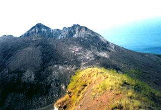
Iliwerung
Indonesia
8.532°S, 123.573°E; summit elev. 583 m
All times are local (unless otherwise noted)
During 17-26 October 2001 the Volcanological Survey of Indonesia reported an increase in felt earthquakes. A total of 2-11 events occurred per day, with Mercalli magnitudes of I-II. The earthquakes S and P wave arrival times differed by between 1 and 35 seconds. Visual and instrumental monitoring revealed a lack of significant changes. The Alert Level was increased from 1 to 2 (on a scale of 1-4). No further reports were issued through at least May 2003.
Geological Summary. Constructed on the southern rim of the Lerek caldera, Iliwerung forms a prominent south-facing peninsula on Lembata (formerly Lomblen) Island. Craters and lava domes have formed along N-S and NW-SE lines on the complex volcano; activity has been observed at vents from the summit to the submarine SE flank. The summit lava dome was formed during an eruption in 1870. In 1948 the Iligripe lava dome grew on the E flank at 120 m elevation. Beginning in 1973-74, when three ephemeral islands were formed, submarine eruptions began on the lower ESE flank at a vent named Hobal; several other eruptions have since taken place at this vent.
Information Contacts: Dali Ahmad, Volcanological Survey of Indonesia (VSI), Jalan Diponegoro No. 57, Bandung 40122, Indonesia (URL: http://www.vsi.esdm.go.id/).