Report on Reventador (Ecuador) — June 2003

Bulletin of the Global Volcanism Network, vol. 28, no. 6 (June 2003)
Managing Editor: Edward Venzke.
Reventador (Ecuador) Lahars, mudflows, and steam emissions continue through mid-July
Please cite this report as:
Global Volcanism Program, 2003. Report on Reventador (Ecuador) (Venzke, E., ed.). Bulletin of the Global Volcanism Network, 28:6. Smithsonian Institution. https://doi.org/10.5479/si.GVP.BGVN200306-352010
Reventador
Ecuador
0.077°S, 77.656°W; summit elev. 3562 m
All times are local (unless otherwise noted)
After a 26-year repose without signs of unusual activity, Reventador burst unexpectedly into a VEI 4 eruption on 3 November 2002 (BGVN 27:11). A preliminary evaluation indicated that this was one of Ecuador's most powerful eruptions of the past 100 years. The following report provides an update on activity since March 2003 (BGVN 28:02) through mid-July 2003. Available seismic records are incomplete for this period (table 3). However, by late April all types of recorded seismic events had declined to very low levels.
Table 3. Summary of seismic activity at Reventador, 8 March-13 July 2003. Note that data are incomplete. Courtesy of the Instituto Geofísico.
| Date | Long-period | Hybrid | Volcano-tectonic |
| 08-14 Mar 2003 | 120 avg./day | -- | 15 avg./day |
| 24-31 Mar 2003 | 50-60/day | -- | 20-30/day |
| 01-06 Apr 2003 | 42-98/day | 26-65/day | 5-13/day |
| 07-12 Apr 2003 | 63.5 avg./day | 30 avg./day | 2.33 avg./day |
| 13 Apr 2003 | 58 | -- | 6 |
| 14 Apr 2003 | 29 | -- | 3 |
| 15 Apr 2003 | 35 | -- | 8 |
| 16 Apr 2003 | 37 | -- | 6 |
| 17 Apr 2003 | 31 | -- | 8 |
| 18 Apr 2003 | 22 | -- | 8 |
| 19 Apr 2003 | 20 | -- | 6 |
| 28 Apr-02 May 2003 | 0 | -- | 0 |
| 03 May 2003 | 1 | -- | 1 |
| 04 May 2003 | 0 | -- | 0 |
| 30 Jun-06 Jul 2003 | 1 | -- | 4 |
| 07-13 Jul 2003 | 2 | -- | 2 |
Heavy rains in March 2003 mixed with ash on Reventador's flanks, causing mudflows and lahars that disrupted traffic along routes crossing rivers draining the volcano (figure 12). A gas column reached 300-500 m above the summit early in the month. Low-level seismicity was characterized by bands of harmonic tremor and a few isolated earthquakes; long-period (LP) seismic events were possibly associated with gas discharges. The seismic station in Copete registered high-frequency signals associated with lahars; however, only a few lahars were observed. Activity during the last week of March was characterized by persistent low-energy emissions of white steam and yellowish gases. Seismicity was also low during this time. The reference seismic station was moved nearer to the volcano, allowing detection of smaller magnitude earthquakes.
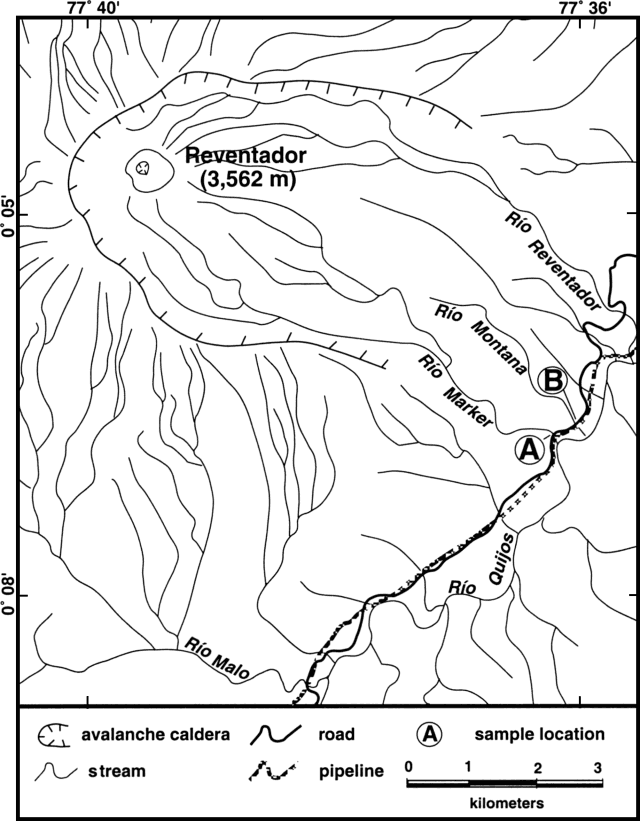 |
Figure 12. Map showing drainages from Reventador and the location of roads and pipelines SE of the volcano. Courtesy of the Instituto Geofisico. |
When the weather permitted in April and May 2003, observers saw continuous low-level emissions of white steam and yellow gases rising several hundreds of meters above the volcano's cone. This was corroborated by the seismicity recorded at station LAVA2 (inside the caldera near the lava front). Rains have been frequent, generally of short duration, and accompanied by some lahars. Low-frequency tremor on 12 April was recorded at LAVA2 (0.9 Hz) and CONE (1.3 Hz), in the caldera NE of the cone near the head of the Rio Reventador. During April, rivers swelled with water and mud that blocked river crossings. Seismicity was characterized by a fairly constant number of long-period (LP)/hybrid and volcano-tectonic (VT) events, with a slight diminution in the number of LPs (table 1). Lahars on 18-19 April produced significant flooding in Rio Reventador and Rio Marker. Seismic activity stayed at very low levels.
On 1 May strong rains in the area of the volcano generated mud flows or lahars that destroyed the highway in the Rio Reventador sector. Heavy rainfall of up to 200 mm in less than 24 hours on 6 May led to the remobilization of ash from the November 2002 eruption. Lahars traveled down the SE flank via the Rio Marker and Rio Reventador gorges. Seismic signals indicated that lahars occurred in seven main pulses, with the longest pulse lasting ~2 hours. Lahars crushed a portion of the petroleum pipeline on the SE flank and dragged it 22 m. Lahars also destroyed a bridge and blocked a highway. On 8 May, satellite images showed a plume that extended ~50 km NW.
During much of June and July 2003, the volcano was not visible due to cloudiness. Seismic activity during June was characterized by bands of continuous tremor, some related to increased volume of the rivers and/or mud flows. On 19 June, a steam plume reached a height of ~300 m. Seismic tremor was associated with flowing gas and observed emissions. Small seismic events (magnitudes less than 3.4) occurred on 23 and 25 June. During 30 June-1 July a gas column was observed that rose ~200 m and drifted W. Seismicity was at low levels in early July, but continuous tremor occurred associated with degassing.
Geological Summary. Volcán El Reventador is the most frequently active of a chain of Ecuadorian volcanoes in the Cordillera Real, well east of the principal volcanic axis. The forested, dominantly andesitic stratovolcano has 4-km-wide avalanche scarp open to the E formed by edifice collapse. A young, unvegetated, cone rises from the amphitheater floor to a height comparable to the rim. It has been the source of numerous lava flows as well as explosive eruptions visible from Quito, about 90 km ESE. Frequent lahars in this region of heavy rainfall have left extensive deposits on the scarp slope. The largest recorded eruption took place in 2002, producing a 17-km-high eruption column, pyroclastic flows that traveled up to 8 km, and lava flows from summit and flank vents.
Information Contacts: Geophysical Institute, National Polytechnical School, Campamento, San Rafael, Ecuador (URL: http://www.igepn.edu.ec/).