Report on Ulawun (Papua New Guinea) — July 2004

Bulletin of the Global Volcanism Network, vol. 29, no. 7 (July 2004)
Managing Editor: Richard Wunderman.
Ulawun (Papua New Guinea) Thin white-and-blue vapor emissions but otherwise quiet during July
Please cite this report as:
Global Volcanism Program, 2004. Report on Ulawun (Papua New Guinea) (Wunderman, R., ed.). Bulletin of the Global Volcanism Network, 29:7. Smithsonian Institution. https://doi.org/10.5479/si.GVP.BGVN200407-252120
Ulawun
Papua New Guinea
5.05°S, 151.33°E; summit elev. 2334 m
All times are local (unless otherwise noted)
Ulawun remained quiet during July 2004. Emissions from the main vent consisted of white vapor being released at moderate rates. Wisps of blue vapor were reported on 4-5, 7, and 12-14 July. No noise or night-time glow was reported during the month. Emission of thin white vapor from the two N-valley vents was reported during 4-6 July. Seismic activity was at a low level. Ground deformation continued to show a steady uplift that began late last year.
Air Niugini pilot David Innes noted on 23 August that he had flown past Uluwan early the previous week and noted what appeared to be steam and light 'smoke,' but did not note any ash.
The Darwin Volcanic Ash Advisory Center posted two reports on Ulawun. The initial 22 August report noted "thin plume to FL 100 [~ 3 km altitude] extends 60 NM [~ 110 km] to SW on NOAA 15 [image of 2038 UTC on 22 August] . . .. At 0330 UTC on 23 August ash was not identifiable from satellite data."
Andrew Tupper reported that on the morning of 23 August satellite imagery showed a plume ~ 50 km long escaping from Ulawun (figure 9). He went on to comment that the light at that time and the meteorological conditions were perfect for creating and seeing plumes. Discussion with RVO suggested that Ulawun often steams in roughly the same manner, but that atmospheric conditions are only sometime advantageous for seeing the plume. Tupper noted that "In stagnant and/or unstable air, the plume might rise higher above the volcano, but be less visible to satellites (and be obscured by convective clouds); fresh dry-season airflow is by far the best for creating and spotting plumes."
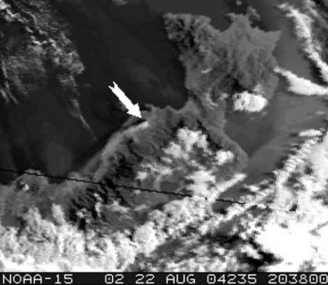 |
Figure 9. NOAA satellite image of plume from Ulawun taken on 22 August. Arrow points to Ulawun; the plume was ~ 50-60 km long. Courtesy of Andrew Tupper. |
Geological Summary. The symmetrical basaltic-to-andesitic Ulawun stratovolcano is the highest volcano of the Bismarck arc, and one of Papua New Guinea's most frequently active. The volcano, also known as the Father, rises above the N coast of the island of New Britain across a low saddle NE of Bamus volcano, the South Son. The upper 1,000 m is unvegetated. A prominent E-W escarpment on the south may be the result of large-scale slumping. Satellitic cones occupy the NW and E flanks. A steep-walled valley cuts the NW side, and a flank lava-flow complex lies to the south of this valley. Historical eruptions date back to the beginning of the 18th century. Twentieth-century eruptions were mildly explosive until 1967, but after 1970 several larger eruptions produced lava flows and basaltic pyroclastic flows, greatly modifying the summit crater.
Information Contacts: Ima Itikarai and Herman Patia, Rabaul Volcano Observatory (RVO), P. O. Box 386, Rabaul, Papua New Guinea; David Innes, Air Niugini, PO Box 7186, Boroko, Port Moresby, National Capital District, Papua New Guinea (URL: http://www.airniugini.com.pg/); Andrew Tupper, Darwin Volcanic Ash Advisory Centre (VAAC), Commonwealth Bureau of Meteorology, Northern Territory Regional Office, PO Box 40050, Casuarina, NT 0811, Australia (URL: http://www.bom.gov.au/info/vaac/).