Report on Soputan (Indonesia) — August 2005

Bulletin of the Global Volcanism Network, vol. 30, no. 8 (August 2005)
Managing Editor: Richard Wunderman.
Soputan (Indonesia) Sporadic explosions into mid-2005; photo of 18 July pyroclastic flow
Please cite this report as:
Global Volcanism Program, 2005. Report on Soputan (Indonesia) (Wunderman, R., ed.). Bulletin of the Global Volcanism Network, 30:8. Smithsonian Institution. https://doi.org/10.5479/si.GVP.BGVN200508-266030
Soputan
Indonesia
1.112°N, 124.737°E; summit elev. 1785 m
All times are local (unless otherwise noted)
On 18 October 2004 Soputan exploded, releasing a column of white-to-gray ash floating as high as 600 m above the crater rim and drifting E (BGVN 29:12).
On 12 December an eruption around 0050 produced an E-drifting ash cloud to ~ 1 km above the volcano. It was followed by a "hot cloud" that traveled about 200 m E towards Aeseput and a lava flow that traveled SW. The eruption was preceded by increased tremor on 11 December and visible incandescence in the crater. The Directorate of Volcanology and Geological Hazard Mitigation increased the Alert Level to 2 (on a scale of 1-4). According to the Darwin Volcanic Ash Advisory Centre an eruption cloud was visible on satellite imagery on 12 December at 0925 at an altitude of ~ 10.7 km.
On 1 February 2005 white vapor rose 50-75 m above the summit. Soputan began to erupt again at 0630 on 20 April, with a plume reaching ~ 1 km above the summit and drifting SE. In addition, lava fountains rose ~ 200 m above the volcano. From 1720 on 20 April until 0900 on 21 April, lava fountains rose 75-100 m. Rapid dome growth occurred and by 21 April the lava dome had spread about 250 m E and 200 m SW. On 22 April a "white ash plume" rose ~ 100 m, and on 23 April a dark gray ash plume rose to ~ 150 m and drifted NE. Ash eruptions through 24 April produced plumes to ~ 300 m above the volcano.
On 9 May a plume of white vapor rose 75 m above the summit. Soputan remained at Alert Level 2 through 9 May.
Further activities came to light as a result of a photograph taken during a violent eruption (figure 2). According to Syamsul Rizal, the photo was taken from Soputan volcano observatory, Maliku, ~ 12 km NW, on 18 July 2005. The eruption initially vented at the usual source on the NE flank. The pyroclastic flow that resulted was described from visible observations as less dense than those from collapses at Merapi and similar to those from Karangetang.
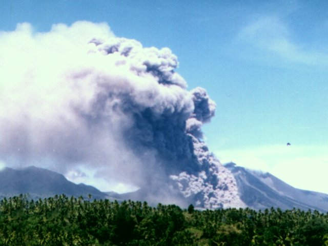 |
Figure 2. A photo of Soputan on 18 July 2005 showing the pyroclastic flow that occurred as a result of dome collapse. Photo courtesy of DVGHM and taken by Farid Bina. |
Geological Summary. The Soputan stratovolcano on the southern rim of the Quaternary Tondano caldera on the northern arm of Sulawesi Island is one of Sulawesi's most active volcanoes. The youthful, largely unvegetated volcano is the only active cone in the Sempu-Soputan volcanic complex, which includes the Soputan caldera, Rindengan, and Manimporok (3.5 km ESE). Kawah Masem maar was formed in the W part of the caldera and contains a crater lake; sulfur has been extracted from fumarolic areas in the maar since 1938. Recent eruptions have originated at both the summit crater and Aeseput, a prominent NE-flank vent that formed in 1906 and was the source of intermittent major lava flows until 1924.
Information Contacts: Directorate of Volcanology and Geological Hazard Mitigation (DVGHM), Jalan Diponegoro 57, Bandung 40122, Indonesia (URL: http://www.vsi.esdm.go.id/); Andrew Tupper, Darwin Volcanic Ash Advisory Centre (VAAC), Bureau of Meteorology, Northern Territory Regional Office, PO Box 40050, Casuarina, Northern Territory 0811, Australia (URL: http://www.bom.gov.au/info/vaac/soputan.shtml).