Report on Reventador (Ecuador) — August 2005

Bulletin of the Global Volcanism Network, vol. 30, no. 8 (August 2005)
Managing Editor: Richard Wunderman.
Reventador (Ecuador) Generally, activity shifting from effusive towards explosive
Please cite this report as:
Global Volcanism Program, 2005. Report on Reventador (Ecuador) (Wunderman, R., ed.). Bulletin of the Global Volcanism Network, 30:8. Smithsonian Institution. https://doi.org/10.5479/si.GVP.BGVN200508-352010
Reventador
Ecuador
0.077°S, 77.656°W; summit elev. 3562 m
All times are local (unless otherwise noted)
Reventador ceased extruding significant new lava flows in early July 2005. Subsequent activity through this report interval, late September, was manifested as intermittent explosive eruptions. These were characterized alternately as Strombolian activity and short-duration Vulcanian events.
After the post-effusive phase and during the explosive phase a significant Vulcanian event took place at 2058 on 12 September, producing an ash column more than 5 km above the summit. Large bombs were ejected more than 2 km from the vent and small pyroclastic flows were evident in gullies descending from the cone. This event was preceded by more than a week of relative quiescence, indicating that future Vulcanian eruptions may occur with little warning.
This report was submitted by Jeffrey B. Johnson (University of New Hampshire), who collaborated with colleagues including Patricio Ramón, Liliana Troncoso, Guillermo Viracucha, Jaime Lozada, Daniel Andrade, David Rivero, Gorky Ruiz, Pete Hall, and Wilson Enriquez (Geophysical Institute, Escuela Politécnica Nacional, IG-EPN). They adhered to the practice of numerically naming lava flows, for example Lava ##5.
End of significant lava effusions. BGVN 30:05 provided a detailed overview of recent active lavas erupted by Reventador between April 2005 and the end of June 2005. Visits to the caldera on 1 July revealed dramatic diminution in the advance rate of Lava ##5 along the southern caldera margin. Within the first few days of July, Lava ##5 had stagnated. Its furthest extent was ~ 4.5 km from the vent and about 50 m short of the furthest extent of Lava ##4 (erupted in May 2005), which it was overriding.
Since the first few days in July, major lava extrusion had terminated. Despite intermittent MODIS thermal alerts (~ 1 per week from University of Hawaii (HIGP)), no significant lava flows have been directly observed by IG-EPN personnel or reported by the local populace. During July, it is likely that small lava flow(s) (under 1 km in length) were extruded from the southern breach of the cone during short-lived events lasting a few days or less. For instance, a photo taken on 1 August (figure 23) indicates a short, fresh lobe (named Lava ##6), which was no longer incandescent during a night-time visit on 3 August.
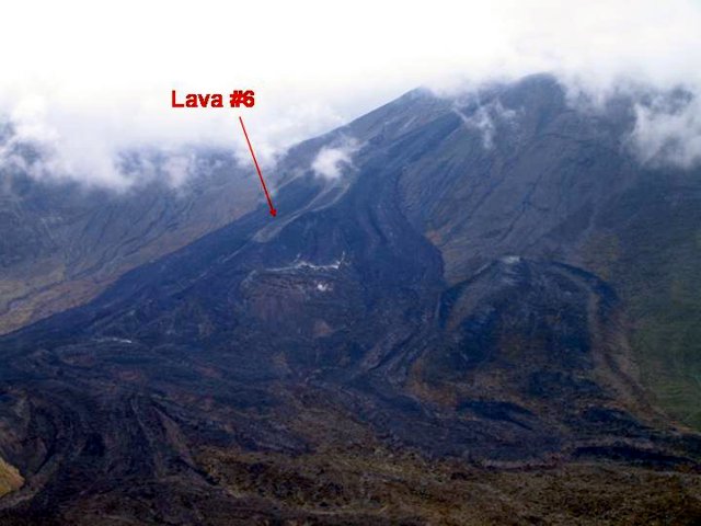 |
Figure 23. Photograph of a fresh lava flow at Reventador on 1 August 2005. The flow, which appears as a white lobe, was stagnant. Courtesy of J. Johnson and the Geophysical Institute. |
Explosive activity. Pyroclastic explosions, which first occurred in early June 2005, continued intermittently until 25 September 2005. Significant Strombolian activity was noted at night by the local populace in the first few days of July, coincident with the decline of Lava ##5 extrusion. In mid-July, explosive activity was minimal, but increased towards the end of the month and during August. Between explosions, voluminous vapor plumes were often observed and loud degassing sounds were often audible, but at times the volcano was also completely silent. Incandescence was also often visible in the cone, suggesting an open-vent configuration. Periods of quiescence separated explosive activity and generally lasted hours to days. Typical eruptive events, which occurred as many as 26 times a day (i.e., on 15 September), are identified clearly by seismic records. These emissions tend to alternate between discrete pyroclastic-laden, ash-rich explosions and extended-duration Strombolian-type fountaining (figure 24). Both types of events were capable of erupting large blocks up and over the crater rim (~ 200 m above the vent), which were often sufficiently massive to be visible from the highway ~ 7.5 km distant.
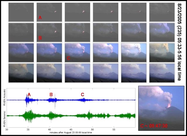 |
Figure 24. Strombolian activity at Reventador depicted in a sequence of still images taken at one-minute intervals along with accompanying infrasonic and seismic traces (signals recorded ~ 1.8 km from the vent). Courtesy of J. Johnson and the Geophysical Institute. |
A period of relative quiescence, marked by an absence of large ash-generating plumes, was evident at the end of August and during first days of September. Vent incandescence was also notably absent during several days up until the large explosion at ~ 2058 on 12 September.
Preceded by a swarm of small volcano-tectonic events, the explosion was manifested by very short-duration transient signals, with arriving infrasonic and seismic waves lasting less than ~ 1 minute. However, peak-to-peak amplitudes the respective signals (~ 211 Pa and 4.9 mm/s) were substantially greater than other explosive events occurring at the volcano during recent months.
As previously mentioned, this short-duration explosion generated a more than 5 km-high ash-cloud and ejected large bombs aerially to more than 2 km. Small pyroclastic flows were confined to gullies on the cone and reached at least 1.5 km from the vent (figure 25).
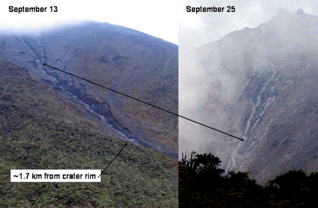 |
Figure 25. Photos of Reventador cone taken 12 days apart (13 and 25 September 2005, from different angles) show the channels and deposits of small pyroclastic flows. Arrow connects same location on cone in both frames. Courtesy of J. Johnson and the Geophysical Institute. |
Since this large event, incandescence has been routinely present in the crater and explosions have occurred with greater frequency (figure 26). Further large explosions occurring in the morning of 24 September were likely responsible for more pyroclastic deposits evident on the upper cone and in upper-flank gullies (figure 25, right-hand photo).
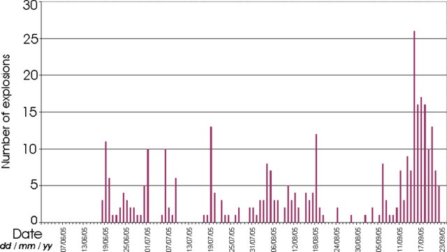 |
Figure 26. Summary of explosion counts at Reventador as identified by the IG-EPN seismic network between 1 June and 23 September 2005. Courtesy of J. Johnson and the Geophysical Institute. |
Monitoring. Reventador continues to be closely monitored by the IG-EPN (figure 27). A telemetered seismic network, consisting of three local short-period seismometers, is used to quantify the eruptive chronology of the volcano, including the quantities of volcano-tectonic events (VT), long-period events (LP), hybrid events, and harmonic and spasmodic tremor, and explosion events. Three temporary stand-alone dataloggers with broad-band seismometers and infrasonic microphones, installed with collaboration from the University of New Hampshire and the University of North Carolina, have supplemented this network throughout the summer.
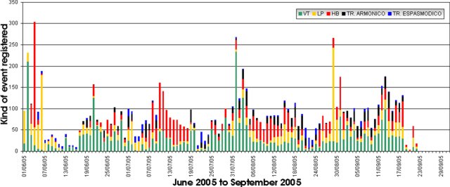 |
Figure 27. Summary of Reventador seismicity since 1 June 2005. Many of the tremor events were associated with vigorous degassing at the vent. Courtesy of J. Johnson and the Geophysical Institute. |
Additionally, field visits by IG-EPN personnel have been conducted regularly. During an expedition on August 28, Differential Optical Absorption Spectroscopy (DOAS) and Forward Looking Infrared (FLIR) measurements were made to assess gas and thermal flux, respectively. DOAS measurements revealed a continuing flux of SO2 estimated at ~ 850 tons/day. The FLIR measurements confirmed near-magmatic temperatures at the vent. It also confirmed stagnation of all lava flows on the volcano since their maximum surface temperatures had cooled into the range of ~ 50°C.
Geological Summary. Volcán El Reventador is the most frequently active of a chain of Ecuadorian volcanoes in the Cordillera Real, well east of the principal volcanic axis. The forested, dominantly andesitic stratovolcano has 4-km-wide avalanche scarp open to the E formed by edifice collapse. A young, unvegetated, cone rises from the amphitheater floor to a height comparable to the rim. It has been the source of numerous lava flows as well as explosive eruptions visible from Quito, about 90 km ESE. Frequent lahars in this region of heavy rainfall have left extensive deposits on the scarp slope. The largest recorded eruption took place in 2002, producing a 17-km-high eruption column, pyroclastic flows that traveled up to 8 km, and lava flows from summit and flank vents.
Information Contacts: Jeffrey B. Johnson, Dept. of Earth Sciences, University of New Hampshire, Durham, NH 03824, USA; Patricio Ramón, Liliana Troncoso, Guillermo Viracucha, Jaime Lozada, Daniel Andrade, David Rivero, Gorky Ruiz, Pete Hall, and Wilson Enriquez, Geophysical Institute (IG), Escuela Politécnica Nacional, Apartado 17-01-2759, Quito, Ecuador (URL: http://www.igepn.edu.ec/).