Report on Nyiragongo (DR Congo) — December 2006

Bulletin of the Global Volcanism Network, vol. 31, no. 12 (December 2006)
Managing Editor: Richard Wunderman.
Nyiragongo (DR Congo) Activity within the crater lake due to lava bubbles and fountain
Please cite this report as:
Global Volcanism Program, 2006. Report on Nyiragongo (DR Congo) (Wunderman, R., ed.). Bulletin of the Global Volcanism Network, 31:12. Smithsonian Institution. https://doi.org/10.5479/si.GVP.BGVN200612-223030
Nyiragongo
DR Congo
1.52°S, 29.25°E; summit elev. 3470 m
All times are local (unless otherwise noted)
Due to political turmoil and civil unrest, expeditions to Nyiragongo's summit lava lake are rare. Two expeditions to the summit were successful in January and July 2006. Photos of the lava lake provided by expedition leader Marco Fulle and crew are posted on the Stromboli Online website. These photos document the changes in the lake over a six-month period. Thermal anomalies measured with the MODIS satellite and associated with this volcano were nearly continuous at this time due to the lava lake within the summit crater.
Two terraces created from a 1977 (upper) lake and a 2002 (lower) lake are evident in photos from January 2006. Closer views of the lava lake showed bubbles breaking through the very dynamic lake surface. Bubbles continuously bursted through the lake's surface. Near the SW shore line, white sulfur deposits and fumaroles were observed. Lava from fountains at the N shoreline splashed on the E lake shore. By July 2006, the lava lake was smaller and seemingly more crusted over. A large fountain was continuously active on the lake's N shore, generating waves up to 10 m high (figure 35).
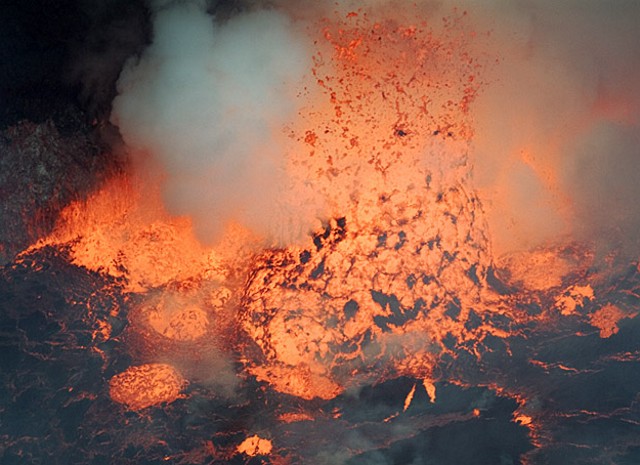 |
Figure 35. Photo of the Nyiragongo lava lake showing a chimney-like fountain agitating the surface and generating waves on the shore at left, 23 July 2006. Courtesy of Stromboli Online. |
Geological Summary. The Nyiragongo stratovolcano contained a lava lake in its deep summit crater that was active for half a century before draining catastrophically through its outer flanks in 1977. The steep slopes contrast to the low profile of its neighboring shield volcano, Nyamuragira. Benches in the steep-walled, 1.2-km-wide summit crater mark levels of former lava lakes, which have been observed since the late-19th century. Two older stratovolcanoes, Baruta and Shaheru, are partially overlapped by Nyiragongo on the north and south. About 100 cones are located primarily along radial fissures south of Shaheru, east of the summit, and along a NE-SW zone extending as far as Lake Kivu. Many cones are buried by voluminous lava flows that extend long distances down the flanks, which is characterized by the eruption of foiditic rocks. The extremely fluid 1977 lava flows caused many fatalities, as did lava flows that inundated portions of the major city of Goma in January 2002.
Information Contacts: Marco Fulle, Stromboli Online and Department of Astronomy, Triste University, Trieste, Italy (URL: http://www.swisseduc.ch/stromboli/perm/nyiragongo/lake-en.html).