Report on Ulawun (Papua New Guinea) — February 2007

Bulletin of the Global Volcanism Network, vol. 32, no. 2 (February 2007)
Managing Editor: Richard Wunderman.
Ulawun (Papua New Guinea) Frequent ash plumes
Please cite this report as:
Global Volcanism Program, 2007. Report on Ulawun (Papua New Guinea) (Wunderman, R., ed.). Bulletin of the Global Volcanism Network, 32:2. Smithsonian Institution. https://doi.org/10.5479/si.GVP.BGVN200702-252120
Ulawun
Papua New Guinea
5.05°S, 151.33°E; summit elev. 2334 m
All times are local (unless otherwise noted)
A previous report (BGVN 31:02) described small earthquakes on 1-2 March 2006, accompanied by "gray-blue emissions." Subsequent ongoing eruptions continued at Ulawun through 18 January 2007, generating almost daily aviation reports describing plumes blowing W to NW and of generally modest height (table 3). The tallest plume of the reporting interval rose to 4.6 km altitude.
Table 3. A summary of key events at Ulawun observed during the reporting interval 22 March 2006-18 January 2007. Reported plumes did not attain an altitude of over 4 km except on 12 November, when they reached an altitude of 4.6 km. Information based primarily on satellite data and pilot reports from the Darwin VAAC and in a few cases, the US Air Force Weather Agency (AFWA).
| Date | Comments |
| 22-28 Mar 2006 | Ash visible at an altitude of ~3 km (pilot report). |
| 09 Apr 2006 | Small low-level plume extending W. |
| 14 May 2006 | An ash plume of unknown height. |
| 25 May 2006 | Thin steam-and-ash plume. |
| 31 May 2006 | A thin steam-and-ash plume reached an altitude of below 3 km. |
| 15 Aug 2006 | Ash-and-steam plume to an altitude of ~3.7 km. |
| 25 Aug 2006 | Steam-and-ash plumes reached altitudes of 3.7 km and drifted NW. |
| 27 Aug 2006 | Steam-and-ash plumes reached altitudes of 3.7 km and drifted W. |
| 28 Aug 2006 | Steam-and-ash plumes reached altitudes of 3.7 km and drifted SW. |
| 30 Aug 2006 | Ash-and-steam plumes drifting SW. |
| 02 Sep 2006 | Ash-and-steam plumes drifting S visible on satellite imagery. |
| 12 Nov 2006 | Diffuse plume to altitude of 4.6 km drifted NW. |
| 16-18 Nov 2006 | Diffuse plumes drifting N and NW. Ash-and-steam plume visible on 18 November. |
| 22 Nov 2006 | Diffuse plume. |
| 28 Nov 2006 | Ash-and-steam plume. |
| 29 Nov 2006 | Diffuse ash-and-steam plume. The altitudes and drift directions were not reported. |
| 04 Dec 2006 | Ash plume. Altitudes and drift directions not reported. |
| 09 Dec 2006 | Diffuse plumes reaching altitudes of 4 km. |
| 11 Dec 2006 | Plumes reached unreported altitudes. |
| 21 Dec 2006 | Ash plumes drifting ENE. |
| 22 Dec 2006 | Ash plumes drifting NW. |
| 25 Dec 2006 | Ash plumes drifting SW. |
| 04 Jan 2007 | Diffuse steam-and-ash plumes drifting SW. |
| 18 Jan 2007 | Pilot report noted an ash plume to an altitude of 2.4 km drifting SW. |
No MODIS thermal alerts were identified between March 2006 and January 2007 on the Hawai'i Institute of Geophysics and Planetology MODIS Thermal Alert System web site. The lack of thermal anomalies may indicate explosive eruptions, and not lava emissions. However, such activity has occurred at the summit in the past. One such episode, in November 1985, generated Strombolian activity and pyroclastic flows (figure 11).
 |
Figure 11. Photograph of Ulawun taken from a helicopter on 25 November 1985. The view from the NE shows emission of large clots of molten lava into the air above the vent and pyroclastic flows (right). The other large stratovolcano in the background is 2,248-m-tall Bamus. Photographs were taken and provided by James Mori, Disaster Prevention Research Institute, Kyoto University. |
Four Volcanic Ash Advisory Centers (VAAC): Tokyo, Washington, Darwin, and Wellington, have an interest in this volcano, because plumes may enter their areas of responsibility (figure 12). The VAACs came into existence to keep aviators informed of volcanic hazards. A key player in their development was the International Civil Aviation Organization (ICAO), a United Nations Related Agency that is the recognized international authority regarding a large number of aviation isses. Nine VAAC were created, in Anchorage (Alaska), Buenos Aires (Argentina), Darwin (Australia), London (England), Montreal (Canada), Tokyo (Japan), Toulouse (France), Washington (United States), and Wellington (New Zealand). These centers are tasked with monitoring volcanic ash plumes and providing Volcanic Ash Advisories (VAA) whenever those plumes enter their assigned airspace. The VAACs are often integrated with aviation weather centers; many have developed back-up sites. For example, the Washington VAAC is backed-up by the US Air Force Weather Agency; the Tokyo by Japan Meteorological Association Headquarters, and Darwin by the National Meteorological & Oceanographic Centre.
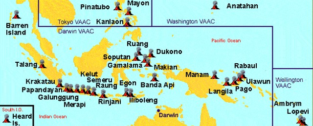 |
Figure 12. Map of Indonesia and Papua New Guinea showing selected volcanoes, including Ulawun on New Britain (right center), with areas of responsibility for local VAACs. Courtesy of Darwin VAAC. |
Geological Summary. The symmetrical basaltic-to-andesitic Ulawun stratovolcano is the highest volcano of the Bismarck arc, and one of Papua New Guinea's most frequently active. The volcano, also known as the Father, rises above the N coast of the island of New Britain across a low saddle NE of Bamus volcano, the South Son. The upper 1,000 m is unvegetated. A prominent E-W escarpment on the south may be the result of large-scale slumping. Satellitic cones occupy the NW and E flanks. A steep-walled valley cuts the NW side, and a flank lava-flow complex lies to the south of this valley. Historical eruptions date back to the beginning of the 18th century. Twentieth-century eruptions were mildly explosive until 1967, but after 1970 several larger eruptions produced lava flows and basaltic pyroclastic flows, greatly modifying the summit crater.
Information Contacts: Rabaul Volcano Observatory (RVO), P. O. Box 386, Rabaul, Papua New Guinea; Darwin Volcanic Ash Advisory Centre (VAAC), Bureau of Meteorology, Northern Territory Regional Office, PO Box 40050, Casuarina, NT 0811, Australia (URL: http://www.bom.gov.au/info/vaac/); US Air Force Weather Agency (AFWA), Satellite Applications Branch, Offutt AFB, NE 68113-4039, USA; Hawai'i Institute of Geophysics and Planetology (HIGP) Thermal Alerts System, School of Ocean and Earth Science and Technology (SOEST), Univ. of Hawai'i, 2525 Correa Road, Honolulu, HI 96822, USA (URL: http://modis.higp.hawaii.edu/); James Mori, Disaster Prevention Research Institute, Kyoto University, Uji, Kyoto 611-0011, Japan (URL: http://eqh.dpri.kyoto-u.ac.jp/~mori/).