Report on Nyiragongo (DR Congo) — March 2007

Bulletin of the Global Volcanism Network, vol. 32, no. 3 (March 2007)
Managing Editor: Richard Wunderman.
Nyiragongo (DR Congo) Summit lava lake persists; studies on volcano, and Lake Kivu gases
Please cite this report as:
Global Volcanism Program, 2007. Report on Nyiragongo (DR Congo) (Wunderman, R., ed.). Bulletin of the Global Volcanism Network, 32:3. Smithsonian Institution. https://doi.org/10.5479/si.GVP.BGVN200703-223030
Nyiragongo
DR Congo
1.52°S, 29.25°E; summit elev. 3470 m
All times are local (unless otherwise noted)
Nearly daily thermal anomalies seen from satellites over the crater of Nyiragongo through early 2007 confirm the presence of the lava lake there. These anomalies were acquired from MODIS satellites and are available on the University of Hawai'i Institute of Geophysics and Planetology (HIGP) MODIS Hotspot Alert website. A separate report in this issue discusses MODIS thermal anomalies measured during the 27 November 2006 eruption of Nyamuragira (BGVN 32:01), located about 10 km NW of Nyiragongo.
The consistent anomalies from the Nyiragongo crater are the result of the lava lake that formed in May 2002 within the volcano's main crater after the January 2002 eruption (BGVN 31:12; Tedesco and others, 2007). Below are brief discussions of several recent articles relevant to risks associated with new efforts in risk monitoring and mitigation at Nyiragongo that have come to our attention.
Giordano and others (2007) describe a multi-disciplinary study involving textural and rheological measurements and numerical simulations of heat transfer during magma ascent for the January 2002 eruption. This study attempted to understand the different behavior of lava flows and their threat to the local population.
Tedesco and others (2007) described activities for monitoring both volcanoes to enhance the capabilities of the Goma Volcanological Observatory (GVO). Owing to difficult security conditions caused by ongoing conflict within the Democratic Republic of Congo, scientists could only install the instruments in seven 'safe havens' that had been established by GVO. To obtain a suitable seismic network geometry (figure 36), three sites (Katale-KTL, Kibumba-KBB, and Kibati-KBT) were located on the eastern side of Nyiragongo. The array of sites allows scientists to distinguish seismic activity at Nyiragongo and Nyamuragira.
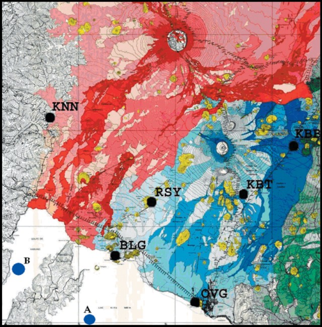 |
Figure 36. Geologic map of Nyiragongo and Nyamuragira, with respective lava flows shaded. Seven seismic stations are shown (KTL, KNN, RSY, KBB, KBT, BLG, and OVG). The points labeled A and B in Lake Kivu indicate the locations of profiles used to monitor the dissolved methane and carbon dioxide found at depth in the lake. According to Schmid and others (2005) the release of a fraction of these gases, which could be triggered by a magma eruption within the lake, would have catastrophic consequences for the two million people living on its shore. Courtesy of Tedesco and others, 2007. |
In detail, the seismic network incorporates a 24-bit analog-to-digital converting unit, GPS synchronization at the remote station, a radio-modem link on the 444-447 megahertz frequency band, solar panels, and batteries. The network uses broadband seismometers manufactured by Lennartz and Nanometrics. Seismic stations can transmit a 19.2 kilobits per second flow using 25 kHz of bandwidth.
Another article, by Chirico and others (2007), reported on a systematic study of the mitigating effects of the construction of artificial barriers to protect Goma and nearby Gisenyi, Rwanda, based on the Nyiragongo lava flow of 17 January 2002. That eruption stands as a prime example of lava flows impacting a large town (BGVN 26:12, 27:03, 27:04, and 31:12). Major lava flows on the S flank entered the town of Goma and devastated a significant portion of it, leaving more than 50,000 homeless and forcing the spontaneous exodus of nearly all of the residents, mainly into neighboring Rwanda. The study included a computer simulation of the effects of such barriers and found that, depending on the size, shape and orientation of the barriers, their protective effects can be optimized, and the local probability of lava flow invasion into the town can be reduced. The study further indicated that barriers will fail to protect the Goma international airport, an area of maximum flow hazard because of its vulnerable location with respect to the peculiar characteristics of the morphology of the terrain.
References. Chirico, G.D., Favalli, M., Papale, P., and Pareschi, M.T., 2007, Lava flow hazard map and mitigation from artificial barriers at Nyiragongo volcano through numerical simulations of lava flow paths: Geophysical Research Abstracts, European Geosciences Union, v. 9, 02238, SRef-ID: 1607-7962/gra/EGU2007-A-02238.
Giordano, D., Polacci, M., Longo, A., Papale, P., Dingwell, D.B., Boschi, E., and Kasereka, M., 2007, Thermo-rheological magma control on the impact of highly fluid lava flows at Mt. Nyiragongo: Geophysical Research Letters, American Geophysical Union, v. 34, L06301, doi:10.1029/2006GL028459.
Schmid, M., Halbwachs, M., Wehrli, B., and W?est, A., 2005, Weak mixing in Lake Kivu: New insights indicate increasing risk of uncontrolled gas eruption: Geochemistry, Geophysics, Geosystems, v. 6, Q07009, doi:10.1029/2004GC000892.
Tedesco, D., Badiali, L., Boschi, E., Papale, P., Tassi, F., Vaselli, O., Kasereka, C., Durieux, J., Denatale, G., Amato, A., Cattaneo, M., Ciraba, H., Chirico, G., Delladio, A., Demartin, M., Favalli, G., Franceschi, D., Lauciani, V., Mavonga, G., Onachesi, G., Pagliuca, N.M., Sorrentino, D., and Yalire, M., 2007, Cooperation on Congo Volcanic and Environmental Risks, Eos, Transactions, American Geophysical Union, v. 88, no. 16, p. 177, 181.
Geological Summary. The Nyiragongo stratovolcano contained a lava lake in its deep summit crater that was active for half a century before draining catastrophically through its outer flanks in 1977. The steep slopes contrast to the low profile of its neighboring shield volcano, Nyamuragira. Benches in the steep-walled, 1.2-km-wide summit crater mark levels of former lava lakes, which have been observed since the late-19th century. Two older stratovolcanoes, Baruta and Shaheru, are partially overlapped by Nyiragongo on the north and south. About 100 cones are located primarily along radial fissures south of Shaheru, east of the summit, and along a NE-SW zone extending as far as Lake Kivu. Many cones are buried by voluminous lava flows that extend long distances down the flanks, which is characterized by the eruption of foiditic rocks. The extremely fluid 1977 lava flows caused many fatalities, as did lava flows that inundated portions of the major city of Goma in January 2002.
Information Contacts: Hawai'i Institute of Geophysics and Planetology, MODIS Thermal Alert System, School of Ocean and Earth Sciences and Technology (SOEST), University of Hawai'i, 2525 Correa Road, Honolulu, HI, USA (URL: http://modis.higp.hawaii.edu/).