Report on Santa Ana (El Salvador) — July 2007

Bulletin of the Global Volcanism Network, vol. 32, no. 7 (July 2007)
Managing Editor: Richard Wunderman.
Santa Ana (El Salvador) Two days visiting the crater lake and fumaroles during mid-2007
Please cite this report as:
Global Volcanism Program, 2007. Report on Santa Ana (El Salvador) (Wunderman, R., ed.). Bulletin of the Global Volcanism Network, 32:7. Smithsonian Institution. https://doi.org/10.5479/si.GVP.BGVN200707-343020
Santa Ana
El Salvador
13.853°N, 89.63°W; summit elev. 2381 m
All times are local (unless otherwise noted)
Researchers from Michigan Technological University (MTU) and Servicio Nacional de Estudios Territoriales (SNET) visited the crater of Santa Ana on 28 June and 5 July 2007 to measure crater lake and fumarole temperatures, and to carry out routine water sampling.
Crater lake. The crater lake appeared yellowish-green and had a maximum temperature of 57.5°C, measured by a thermocouple at the northern shore. The crater lake was observed to have shifted westward in position since the 1 October 2005 eruption, drowning the main pre-eruption fumarole field to the W and receding from its eastern border (figure 13). A subaqueous hot spring was observed in the center of the lake at the end of a peninsula of exposed sediments (figure 14). The hot spring exhibited episodic pulses of bubbling water about every 5 minutes.
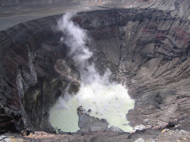 |
Figure 13. The yellowish-green acid crater lake of Santa Ana volcano as seen when viewed on 28 June 2007 looking towards the N. Photo taken by Anna Colvin. |
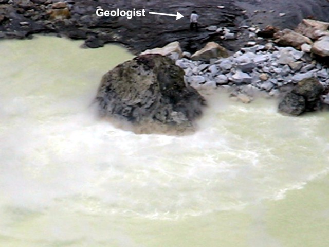 |
Figure 14. Hot spring emerging in the acid lake at Santa Ana as seen 5 July 2007. Episodic upwelling of whitish fluid radiated out from the base of the large rock in the center of the photo. View is towards the SW; note geologist for scale. Photo taken by Matt Patrick. |
Fumaroles. Crater fumaroles were observed to the W and S of the crater lake, and weak fumaroles were also observed on the upper wall above the flat area and below the SW crater rim. The southern crater fumaroles and the upper fumaroles were measured by thermocouple and radiometer (Extech 42545) (figure 15). Fumaroles to the W were not measured due to limited accessibility.
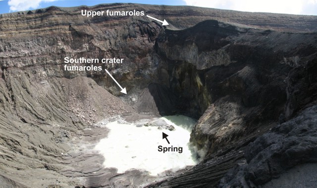 |
Figure 15. At Santa Ana, the location of fumarole measurements and the hot spring shown in the previous figure. View is towards the SW. Photo mosaic taken 5 July 2007 by Matt Patrick. |
The seven largest southern crater fumaroles were measured along an E-W transect. The lower fumaroles emitted mainly water vapor, though some sulfur crystals and a weak sulfurous smell were present. Lower fumaroles temperatures ranged from 92.0 to 95.2°C, and thermocouple and radiometer measurements agreed very well (to within 3%). The upper fumaroles were diffuse and relatively weak, occurring in loosely consolidated tephra. The upper fumaroles emitted mainly water vapor and lacked sulfur deposits or sulfurous smell. Upper fumaroles temperatures ranged from 70.0 to 79.0°C, and thermocouple and radiometer measurements agreed well (to within 6%).
Geological Summary. Santa Ana (also known as Ilamatepec), is a massive, dominantly andesitic-to-trachyandesitic stratovolcano in El Salvador immediately W of Coatepeque Caldera. Collapse during the late Pleistocene produced a voluminous debris avalanche that swept into the Pacific Ocean, forming the Acajutla Peninsula. Reconstruction of the volcano subsequently filled most of the collapse scarp. The broad summit is cut by several crescentic craters, and a series of vents and cones have formed along a 20-km-long fissure system that extends from near the town of Chalchuapa NNW of the volcano to the San Marcelino and Cerro la Olla cinder cones on the SE flank. Small to moderate explosive eruptions from both summit and flank vents have been documented since the 16th century. The San Marcelino cinder cone on the SE flank produced a lava flow in 1722 that traveled 13 km E.
Information Contacts: Demetrio Escobar and Francisco Montalvo, Servicio Nacional de Estudios Territoriales, SNET, Km. 5 1/2 carretera a Santa Tecla y Calle las Mercedes, contiguo a Parque de Pelota, Edificio SNET, Apartado Postal ##27, Centro de Gobierno, El Salvador 2283-2246 (URL: http://www.snet.gob.sv/); Matthew Patrick and Anna Colvin, Dept. of Geological and Mining Engineering and Sciences, Michigan Technological University, 1400 Townsend Drive, Houghton, MI 49931, USA.