Report on San Miguel (El Salvador) — September 2007
Bulletin of the Global Volcanism Network, vol. 32, no. 9 (September 2007)
Managing Editor: Richard Wunderman.
San Miguel (El Salvador) Background seismicity since October 2006; crater visit in July 2007
Please cite this report as:
Global Volcanism Program, 2007. Report on San Miguel (El Salvador) (Wunderman, R., ed.). Bulletin of the Global Volcanism Network, 32:9. Smithsonian Institution. https://doi.org/10.5479/si.GVP.BGVN200709-343100
San Miguel
El Salvador
13.434°N, 88.269°W; summit elev. 2130 m
All times are local (unless otherwise noted)
A sudden increase in seismicity occurred on 9 October 2006 but no landslides or rock falls were associated with the event and it was attributed to gas emissions in the crater (BGVN 31:10). This report carries on from 9 October 2006.
During the morning of 10 October 2006, seismic activity declined to a continuous vibration with an amplitude that oscillated between 50 and 75 RSAM (real-time seismic amplitude measurement) units. This condition continued until 0600 on 11 October, when the seismicity increased to 125 continuous RSAM units.
The responsible authorities issued an alert that encompassed an area within 4 km from the center of the crater. Because of the elevated energy level of seismicity relative to the previous activity, the National Service of Territorial Studies elected to monitor the volcano and report developments to the National System of Civil Defense.
As of 15 October 2006, the level of activity at San Miguel was considered to be moderate, implying the possibility of an eruption sometime in the next several months. The civil defense authorities established a Yellow alert level (phase 3) for the area within 4 km of the crater center but later reduced it to Green. Around 15 October the RSAM continued to vary from 8 units to 45 units. During the preceding 24 hours, 55 earthquakes were registered; however, none were noticed by the local population. Sulfur dioxide (SO2) fluxes reached 150-250 metric tons per day, which was considered a low level. On 16 October, tremor fluctuated between 45 and 50 units, and 25 earthquakes were recorded but not felt by residents.
The period from the October 2006 activity through July 2007 was essentially devoid of any abnormal variations in seismicity, volcanism, or elevated gas emissions.
On 4 July 2007, volcanologists from Servicio Nacional de Estudios Territoriales (SNET) and Michigan Technological University climbed San Miguel to make observations and take fumarole temperatures. The volcano remained at a low level of activity. The crater morphology and the intensity and location of fumaroles within the crater remained similar to that observed in recent visits (e.g., October 2006 BGVN 31:10). The main fumarolic area was near the bottom of the crater on the S wall (figure 8). Other sparse fumaroles were present, with most clustered near the crater bottom and on the crater's W wall.
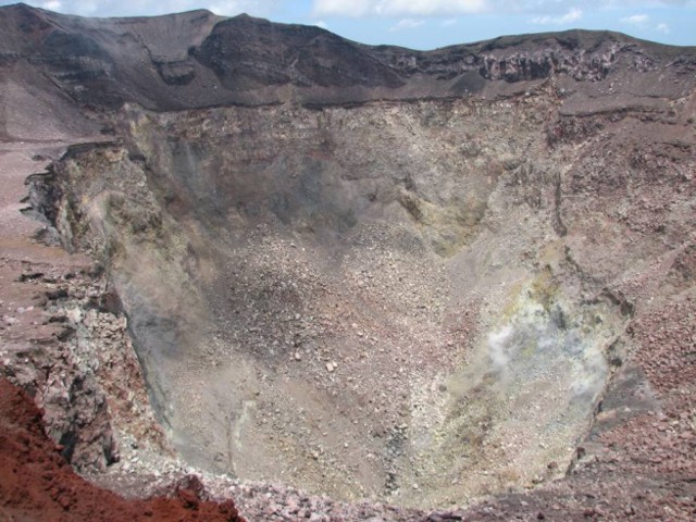 |
Figure 8. View of the crater at San Miguel, looking S on 4 July 2007. The whitish area in the bottom right of the photo reflects steaming from the main fumarole field. Courtesy of Servicio Nacional de Estudios Territoriales (SNET) and Michigan Technological University. |
Fumarole measurements: Temperatures were measured at two fumarolic areas on the upper W crater wall (figure 9). These are visited by SNET on a regular basis and comprise the only fumaroles safely accessible from the rim. Temperatures at fumaroles 1 and 2 were 67°C and 57°C, respectively. The gas lacked any sulfurous smell, suggesting water vapor only. These fumarole temperatures are similar to those measured in recent visits.
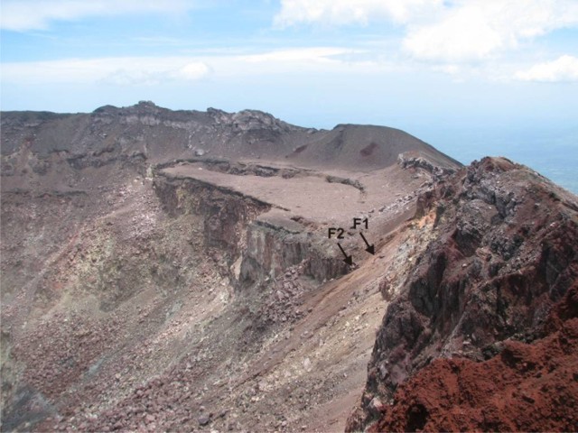 |
Figure 9. View of the W side of San Miguel's crater, taken from the N rim. Fumaroles 1 (F1) and 2 (F2) are in the right central portion of the image. Courtesy of Servicio Nacional de Estudios Territoriales (SNET) and Michigan Tech University. |
References. Chesner, C.A., Pullinger, C., Escobar, C.D., 2003, Physical and chemical evolution of San Miguel Volcano, El Salvador. GSA Special Paper 375.
Escobar, C.D., 2003, San Miguel Volcano and its Volcanic Hazards: MS thesis, Michigan Technological University, December 2003, 163 p.
Major, J.J., Schilling, S.P., Pullinger, C.R., Escobar, C.D., Chesner, C.A, and Howell, M.M., 2001, Lahar-Hazard Zonation for San Miguel Volcano, El Salvador: U.S. Geological Survey Open-File Report 01-395 (Available on-line).
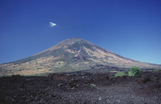
Geological Summary. The symmetrical cone of San Miguel, one of the most active volcanoes in El Salvador, rises from near sea level to form one of the country's most prominent landmarks. A broad, deep, crater complex that has been frequently modified by eruptions recorded since the early 16th century caps the truncated unvegetated summit, also known locally as Chaparrastique. Flanks eruptions of the basaltic-andesitic volcano have produced many lava flows, including several during the 17th-19th centuries that extended to the N, NE, and SE. The SE-flank flows are the largest and form broad, sparsely vegetated lava fields crossed by highways and a railroad skirting the base of the volcano. Flank vent locations have migrated higher on the edifice during historical time, and the most recent activity has consisted of minor ash eruptions from the summit crater.
Information Contacts: Eduardo Gutierrez, Demetrio Escobar, and Francisco Montalvo, Servicio Nacional de Estudios Territoriales (SNET), Km. 5 ½ carretera a Santa Tecla y Calle las Mercedes, contiguo a Parque de Pelota, Edificio SNET, Apartado Postal #27, Centro de Gobierno, El Salvador (URL: http://www.snet.gob.sv/); Matthew Patrick and Anna Colvin, Dept. of Geological and Mining Engineering and Sciences, Michigan Tech University, 1400 Townsend Drive, Houghton, MI 49931, USA.