Report on Reventador (Ecuador) — March 2009

Bulletin of the Global Volcanism Network, vol. 34, no. 3 (March 2009)
Managing Editor: Richard Wunderman.
Reventador (Ecuador) Lava extrudes down two flanks during November 2008-April 2009
Please cite this report as:
Global Volcanism Program, 2009. Report on Reventador (Ecuador) (Wunderman, R., ed.). Bulletin of the Global Volcanism Network, 34:3. Smithsonian Institution. https://doi.org/10.5479/si.GVP.BGVN200903-352010
Reventador
Ecuador
0.077°S, 77.656°W; summit elev. 3562 m
All times are local (unless otherwise noted)
Our previous report covered activity through early August 2008, a period that included extrusions of lava flows (BGVN 33:08). This report continues through late April 2009, including a hiatus for much of August into November 2008. In early November observers saw repeated small eruptions emitting plumes with generally minor ash, Strombolian eruptions, and lava flows down two flanks. What follows summarizes reports from the Instituto Geofísico-Escuela Politécnica Nacional (IG).
The last paragraph of the main section of this report discusses an important temporal and spatial correlation made at the volcano on 23 April 2009. The IG correlated satellite thermal data and ground-based observations with high tremor and acoustical noise.
An IG daily report issued 8 August 2008 noted a lack of movement in the lava flows and the emission of gas plumes without ash. That night, glow was observed from the crater. On 18 August, amid rainy conditions, a possible lahar was noted. Except for ongoing seismicity, relative calm prevailed until early November.
The IG noted glow from the crater the night of 7 November, an observation confirmed in satellite thermal data. At 1900 on 8 November high-amplitude seismic signals saturated the seismic stations. Local observers saw an ash-and-steam column that evening to 2 km above the crater. The ash content was moderate. Another IG report noted that in the settlements of Chaco and Quijos residents could hear strong explosions and see gas plumes with low ash content. A pilot report stated the plume blew NW and reached an approximate estimated altitude of 7.6 km.
Special Report 6 (9 November) included a plot of seismicity since 1 February 2007 (figure 29). Long-period (LP) earthquakes began to dominate in March 2008 and the large spike around 8-9 November 2008 was outstanding compared to the recent pattern. Another larger spike in seismicity had been seen during mid-March 2007, but it was composed of volcano-tectonic (VT) earthquakes.
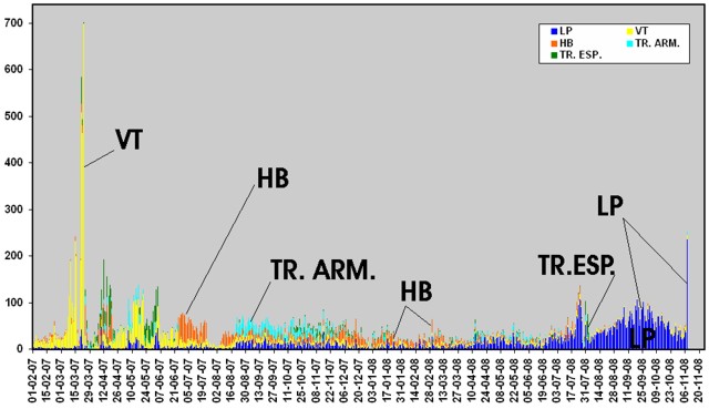 |
Figure 29. A histogram of daily seismicity for Reventador during 1 February 2007 to 8 or 9 November 2008. The plot includes harmonic tremor (TR. ARM.) and special kinds of tremor (TR. ESP.) in addition to more typically plotted event types (LP earthquakes, VT earthquakes, and hybrid (HB) earthquakes). Courtesy of IG (from their Special Report No. 6, issued 9 November 2008). |
A follow up report on 11 November stated that Reventador had discharged moderate strombolian explosions on 9-10 November, with ongoing lava flows on the N and S flanks of the central cone. Both the summit eruptions and the flank flows were conspicuous at night.
SO2 emissions were clear in Aura/OMI imagery of 9 and 10 November (figure 30). About a day later, Reventador calmed considerably (with seismicity dropping strongly after 1000 on 11 November). The escalating activity drove IG to install two more seismometers, two infrasonic sensors, and a monitoring camera.
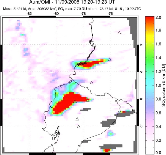 |
Figure 30. Spectroscopic measurements of SO2 taken by the Aura/OMI satellite on 9 November 2009 from eruptions at Reventador. The smaller plume to the N is from Galeras. Courtesy of Simon Carn and the OMI Sulfur Dioxide Group. |
The IG's Special Reports of 10 and 11 November (Numbers 7 and 8) offered further information. Lava flows had descended to below 2,600 m elevation (the summit is at 3,562 m elevation but the vent elevation was not stated). During the night of 9 November incandescent ejecta rose 100 m above the crater, along with continuous roars and canon-shot noises. Although light ash fell in Cayambe on 9 November, other towns in the region had not been affected. Strombolian emissions had calmed some on the night of 10 November. After 1000 on 11 November, both gas emissions and seismicity calmed.
Seismicity increased starting on 15 December 2008, and remained elevated through 8 January 2009. During 3-8 January there were almost constant gas emissions (with ash contents moderate to low), small-to-moderate explosions, and tremor lasting several hours. The tremor was accompanied by roaring noises and the ejection of blocks that landed near the summit. Explosions and emission tremors were of variable intensity, causing windows in nearby towns to vibrate. Ash rose 2 km above the summit and drifted W, causing ashfall in the towns of El Manzano, Choglontus, Palictahua, and Cahuají.
After 8 January 2009, the IG reported the steady decrease of seismic activity. There were a few explosions and water vapor emissions with low ash content reaching heights of 1-1.5 km above the crater. These plumes drifted W and SW, with reported minor ashfall in the towns mentioned above. Associated with these emissions, observers heard sporadic roaring noises. Seismic activity continued to decrease during the latter part of January 2009 and into February 2009. Although in mid-February 2009 there was a mild increase in seismicity, overall the level remained low. A single observation revealed the presence of a small column of steam and gas.
During 16-22 February seismic activity remained low, with few seismic events and signals associated with fluid movements at depth. The number of rockfalls was significant, even compared to that seen during cooling of the lava flow from November 2008. During this week there were various episodes of harmonic tremor and explosions. During 23 February-15 March 2009 there was a slight increase in the number of low-intensity seismic events attributed to fluids at depth. There was a later decrease in seismicity.
IG's 2009 Special Report Number 1 (26 March) noted a seismic increase on 26 March, which they again attributed to fluids moving within the volcanic edifice. After 1000 on the 26th, instruments detected a seismic swarm consisting of both LP and hybrid earthquakes, intercalated with banded tremor, the later of which had a 4-hour duration. From past experience, the IG inferred these signals could reflect the onset of new lava approaching the surface.
Special Report Number 2 (23 April) noted that later on the 26th the signals dropped off and remained low through at least early 23 April. Despite low seismicity, there were both episodes of banded tremor and intercalated LP earthquakes.
The tremor was of variable amplitudes, including some that saturated local seismic stations, particularly between 0500 and 0700 on 23 April 2009. On that day, a low, gas-rich cloud blew W from Reventador. Several residents living near the volcano also heard loud noises. A satellite-detected thermal hotspot on the volcano beginning at 0300 continued, with high intensity, between 0500 and 0700. The presence of the highest intensity thermal anomalies coincided with the highest tremor amplitudes and audible noises. Multiple MODVOLC thermal alerts were detected on 24-25 April and on 8 and 10 May 2009.
Geological Summary. Volcán El Reventador is the most frequently active of a chain of Ecuadorian volcanoes in the Cordillera Real, well east of the principal volcanic axis. The forested, dominantly andesitic stratovolcano has 4-km-wide avalanche scarp open to the E formed by edifice collapse. A young, unvegetated, cone rises from the amphitheater floor to a height comparable to the rim. It has been the source of numerous lava flows as well as explosive eruptions visible from Quito, about 90 km ESE. Frequent lahars in this region of heavy rainfall have left extensive deposits on the scarp slope. The largest recorded eruption took place in 2002, producing a 17-km-high eruption column, pyroclastic flows that traveled up to 8 km, and lava flows from summit and flank vents.
Information Contacts: Geophysical Institute (IG), Escuela Politécnica Nacional, Apartado 17-01-2759, Quito, Ecuador (URL: http://www.igepn.edu.ec/); Simon Carn, Dept of Geological and Mining Engineering and Sciences, Michigan Technological University, 1400 Townsend Dr., Houghton, MI 49931, USA (URL: https://so2.gsfc.nasa.gov/); Hawai'i Institute of Geophysics and Planetology (HIGP) Thermal Alerts System, School of Ocean and Earth Science and Technology (SOEST), Univ. of Hawai'i, 2525 Correa Road, Honolulu, HI 96822, USA (URL: http://modis.higp.hawaii.edu/).