Report on Batu Tara (Indonesia) — October 2009
Bulletin of the Global Volcanism Network, vol. 34, no. 10 (October 2009)
Managing Editor: Richard Wunderman.
Batu Tara (Indonesia) Frequent ash plumes through October 2009
Please cite this report as:
Global Volcanism Program, 2009. Report on Batu Tara (Indonesia) (Wunderman, R., ed.). Bulletin of the Global Volcanism Network, 34:10. Smithsonian Institution. https://doi.org/10.5479/si.GVP.BGVN200910-264260
Batu Tara
Indonesia
7.791°S, 123.585°E; summit elev. 633 m
All times are local (unless otherwise noted)
Batu Tara has been active since January 2007, with thermal anomalies and occasional low-level ash plumes at least through 24 November 2009. This report discusses activity since our previous report (BGVN 34:01), which covered activity through 10 March 2009.
Since 10 March 2009, the eruption of low-level ash plumes has continued at least through 24 November 2009. Many reports of Batu Tara plumes came from the Darwin Volcanic Ash Advisory Centre (table 3).
Table 3. Summary of Volcanic Ash Advisories for Batu Tara reported by the Darwin Volcanic Ash Advisory Centre (VAAC) during 11 March 2009-24 November 2009. Many of these plumes were described as ash plumes. This table continues the table in BGVN 34:01. Courtesy of the Darwin VAAC.
| Date | Plume top altitude (km) | Drift direction(s) and extent |
| 11 Mar 2009 | 2.1 | N, NW |
| 20 Mar 2009 | 2.4 | NW |
| 25-27 Mar 2009 | 2.1 | ~30-110 km NW |
| 05-06 Apr 2009 | 2.4 | 40-210 km W |
| 11-12, 14 Apr 2009 | 1.8-2.4 | 35-90 km W, NW |
| 15-16 Apr 2009 | 1.8-2.4 | 35-75 km W, NW |
| 24-25, 28 Apr 2009 | 3.0 | Up to 110 km in variable directions |
| 29-30 Apr, 03-04 May 2009 | 2.4-3.0 | 45-185 km W, NW |
| 05 May 2009 | 2.4 | 55 km W |
| 14-19 May 2009 | 3.0 | 35-75 km W, NW, N |
| 20 May 2009 | 3.0 | 65 km NW |
| 26 May 2009 | 2.4 | 55 km NW |
| 27 May-02 Jun 2009 | 2.4 | 25-75 km NW, W, SW |
| 03-08 Jun 2009 | 2.4 | 40-75 km NW, W, SW |
| 09 Jun 2009 | -- | 140 km W |
| 10-16 Jun 2009 | 1.5-2.4 | 25-185 km SW, NW, N, NE |
| 25-30 Jun 2009 | 1.5 | 35-130 km SW, W, NW |
| 01-07 Jul 2009 | 1.5-2.4 | 35-110 km W, NW, N |
| 08 Jul 2009 | 2.4 | 55 km W, NW |
| 12-14 Jul 2009 | 1.5 | 25-55 km W, NW, N |
| 15-18 Jul 2009 | 1.5 | 20-55 km in multiple directions |
| 23 Jul 2009 | 2.4 | 55 km W |
| 27-28 Jul 2009 | 1.5 | Up to 150 km NW |
| 29-31 Jul 2009 | 1.5 | Up to 37 km NW, N |
| 04-07 Aug 2009 | 1.5-2.1 | 45-90 km W, NW, N |
| 12-13, 15-17 Aug 2009 | 1.5-3.0 | 5-110 km W, NW, N |
| 19, 21-25 Aug 2009 | 1.5 | 35-150 km W, WNW, NW |
| 26 Aug-01 Sep 2009 | 1.5-2.4 | 15-55 km W, NW, N |
| 02-08 Sep 2009 | 1.5 | 10-55 km W, NW |
| 09-11, 14-15 Sep 2009 | 1.5 | 25-45 km W, NW |
| 16-19, 21-22 Sep 2009 | 1.5 | 20-65 km W, NW, N, NE |
| 23-29 Sep 2009 | 1.5-2.4 | 15-75 km W, NW |
| 30 Sep-03, 05-06 Oct 2009 | 2.4 | 25-75 km W, NW, N |
| 06 Oct 2009 | 2.4 | 65 km W |
| 14-16 Oct 2009 | 1.8 | 25-185 km W, N |
| 27 Oct 2009 | 2.1 | 65 km W, NW |
| 24 Nov 2009 | 2.4 | 90 km NW |
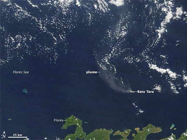
NASA's Earth Observatory described the scene from an image taken on 30 April 2009 (figure 5). "In this true-color picture, Batu Tara looks like a small, smoking speck in the Flores Sea. Initially blowing toward the NW, the volcanic plume changes direction multiple times, forming a large question-mark shape, mingling with clouds in the N. When volcanic gases mingle with oxygen and moisture in the presence of sunlight, vog, or volcanic smog, often results. The off-white color and diffuse shape of the volcanic plume in the N are suggestive of vog." MODVOLC recorded thermal alerts at Batu Tara on 26 and 29 May, and 3 July 2009.
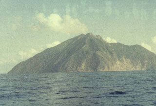
Geological Summary. The small isolated island of Batu Tara in the Flores Sea ~50 km N of Lembata (fomerly Lomblen) Island and the main volcanic arc. A scarp on the eastern side reaches the sea, and vegetation covers the other flanks to within 50 m of the summit. This volcano is noted for its potassic leucite-bearing basanitic and tephritic rocks. The first recorded eruption, during 1847-52, produced explosions and a lava flow.
Information Contacts: Darwin Volcanic Ash Advisory Centre (VAAC), Bureau of Meteorology, Northern Territory Regional Office, PO Box 40050, Casuarina, NT 0811, Australia (URL: http://www.bom.gov.au/info/vaac/); NASA Earth Observatory (URL: http://earthobservatory.nasa.gov/); Hawai'i Institute of Geophysics and Planetology (HIGP) Thermal Alerts System, School of Ocean and Earth Science and Technology (SOEST), University of Hawai'i, 2525 Correa Road, Honolulu, HI 96822, USA (URL: http://modis.higp.hawaii.edu/).


