Report on Ulawun (Papua New Guinea) — May 2011

Bulletin of the Global Volcanism Network, vol. 36, no. 5 (May 2011)
Managing Editor: Richard Wunderman.
Ulawun (Papua New Guinea) Seismicity ongoing with plumes during May 2010-May 2011
Please cite this report as:
Global Volcanism Program, 2011. Report on Ulawun (Papua New Guinea) (Wunderman, R., ed.). Bulletin of the Global Volcanism Network, 36:5. Smithsonian Institution. https://doi.org/10.5479/si.GVP.BGVN201105-252120
Ulawun
Papua New Guinea
5.05°S, 151.33°E; summit elev. 2334 m
All times are local (unless otherwise noted)
This report discusses Ulawun's ongoing mild seismicity, variably colored, though often white plumes, and other observations during May 2010 to late May 2011. The bulk of the reporting came from the Rabaul Volcano Observatory (RVO) with some information on plumes from the Darwin Volcanic Ash Advisory Center (VAAC) and others. Seismicity at Ulawun has generally been low since 2007, with occasional modest increases and steam emission (BGVN 33:03, 34:10, and 35:02).
Activity during 2010. RVO reported that, according to Real-time Seismic Amplitude Measurements (RSAM), seismic activity increased on 18 May 2010. According to RVO, white vapor emitted during 1-20 May 2010 became thicker during 22-28 May. On 22 and 25 May, some plumes were partially gray. According to the Darwin VAAC, plumes on 22-28 May reached an altitude of 3 km and extended as far as 70 NM in variable directions.
People on the S and SE sides of the island heard "low jetting" noises during 24-25 May 2010. Weak and fluctuating incandescence was seen from the S at night during 28-29 May. Emissions became gray in color during 29-31 May, and on 30 May very fine ashfall was reported in areas to the SSW, S, and SSE. On 1 and 2 June only white vapor emissions were noted. RVO recommended a Stage 1 Alert as a result of increasing seismicity and occasional gray plumes, incandescence, and audible noises. According to a news report (Radio Australia), up to 10,000 residents live adjacent to Ulawun.
According to RVO, during 2-12, 16-19, and 23-25 June 2010 residents heard occasional low roaring or rumbling noises daily on the ESE, SE, S, and NW flanks. During 2-19 and 23-26 June, white to gray-brown plumes rose to ~3 km altitude (figure 15). The Darwin VAAC noted that between 3-6 June, the plumes extended up to 315 km W. On 16-17 and 19-20 June, white and gray plumes rose 1 km above the summit. Very fine ash particles fell in Ulamona (~10 km NW) on 3 and 8 June, and then fell daily during 9-19 and 23-25 June on the NW, W, and SW flanks. Throughout June, fluctuating incandescence from the summit crater was seen at night from the S, SW, N, and SE flanks. RVO reported that on 18 and 19 June, seismicity increased to a high level and was dominated by volcanic tremor. Seismicity declined to moderate levels on 20 June and, based on RSAM values, declined further on 26 June 2010.
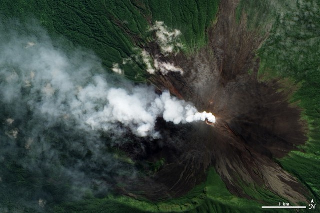 |
Figure 15. Natural-color image of a small white plume venting from Ulawun's summit crater and blowing W on 10 June 2010. Image was taken by the Advanced Land Imager on NASA's Earth Observing-1 (EO-1) satellite. Green vegetation predominates outboard of 1-2 km from the summit. On the upper slopes, bare (unvegetated) volcanic rocks prevail, appearing as charcoal-brown streaks. The plume's pale color suggests that, of the visible components in the plume, steam rather than ash predominates. NASA Earth Observatory image created by Jesse Allen, using EO-1 ALI data provided courtesy of the NASA EO-1 team and the United States Geological Survey. Original (but now slightly revised) caption crafted by Michon Scott. |
According to RVO, white-to-gray plumes rose less than 500 m from Ulawun during 27 June-9 July 2010, and fine ash fell in areas to the SW, W, and NW. The Darwin VAAC reported that during 1-5 July, ash plumes drifted 55-195 km at an altitude of 3 km. On 28 June and during 5-6 July the volcano omitted occasional roaring noises. A slight increase in seismicity (above moderate levels) took place during 5-8 July.
RVO reported diffuse gray plumes that rose 200-500 m above Ulawun during 16-21 July 2010. Plumes were white to light-brown during 21-29 July. During 6-24 August, white and gray-to-brown plumes rose no more than 300 m above Ulawun, and fine ash fell on the NW and W flanks. Tremor continued, but overall seismicity declined slightly. RSAM values remained at a moderate level.
Based on analyses of satellite imagery and information from RVO, the Darwin VAAC reported that on 26 November 2010 an ash plume from Ulawun rose to an altitude of 3.7 km and drifted 55 km NE.
Several videos of Ulawun's plumes as posted on the web in 2010 showed them as white in color (Sabretoothed69, 2010). Other brief video by the same author take viewers to the Ulawun seismic station and its drum recorder, and to witness aspects of local culture such as villagers dancing.
Activity during 2011. According to RVO, the mild activity that began in May 2010 continued during 1 January-28 February 2011. The activity was characterized by brown-to-gray ash plumes that rose less than 500 m and produced fine ashfall to the SE. Sulfur-dioxide plumes drifted SE on 5 and 31 January. During 23-26 February, gray ash plumes occasionally drifted NE, SW, and NW.
RVO reported that during 1-9 May 2011, diffuse white plumes rose from Ulawun and low to modest RSAM values occurred (70-100 units). During 9-10 May, RSAM values distinctly increased, fluctuated, and peaked at 1,300 units before declining back to 100 units. During this time, local residents heard booming.
During 10, 13-14, 17, and 19-27 May, RVO reported gray-to-brown ash plumes rose above Ulawun's summit crater. On 17 May, emissions became briefly forceful and booming noises were reported. Light ashfall deposited between Ubili and Ulamona to the NW and Voluvolu to the NE, as well as on the NW and W flanks. Weak, fluctuating incandescence was observed on 22 May.
Reference. Sabretoothed69, 2010 (uploaded on 7 November 2010), YouTube (URL: http://www.youtube.com/watch?v=UnCSeky3Mes, uploaded by sabretoothed69)
Geological Summary. The symmetrical basaltic-to-andesitic Ulawun stratovolcano is the highest volcano of the Bismarck arc, and one of Papua New Guinea's most frequently active. The volcano, also known as the Father, rises above the N coast of the island of New Britain across a low saddle NE of Bamus volcano, the South Son. The upper 1,000 m is unvegetated. A prominent E-W escarpment on the south may be the result of large-scale slumping. Satellitic cones occupy the NW and E flanks. A steep-walled valley cuts the NW side, and a flank lava-flow complex lies to the south of this valley. Historical eruptions date back to the beginning of the 18th century. Twentieth-century eruptions were mildly explosive until 1967, but after 1970 several larger eruptions produced lava flows and basaltic pyroclastic flows, greatly modifying the summit crater.
Information Contacts: Rabaul Volcano Observatory (RVO), PO Box 386, Rabaul, Papua New Guinea; Darwin Volcanic Ash Advisory Centre (VAAC), Bureau of Meteorology, Northern Territory Regional Office, PO Box 40050, Casuarina, NT 0811, Australia (URL: http://www.bom.gov.au/info/vaac/); NASA Earth Observatory (URL: http://earthobservatory.nasa.gov/); Radio Australia (URL: http://www.radioAustralia.net.au/pacbeat/).